104,99 €
Mehr erfahren.
- Herausgeber: John Wiley & Sons
- Kategorie: Wissenschaft und neue Technologien
- Sprache: Englisch
Explores real-world wireless sensor network development, deployment, and applications
- Presents state-of-the-art protocols and algorithms
- Includes end-of-chapter summaries, exercises, and references
- For students, there are hardware overviews, reading links, programming examples, and tests available at [website]
- For Instructors, there are PowerPoint slides and solutions available at [website]
Sie lesen das E-Book in den Legimi-Apps auf:
Seitenzahl: 306
Veröffentlichungsjahr: 2016
Ähnliche


IEEE Press445 Hoes Lane Piscataway, NJ 08854
IEEE Press Editorial BoardTariq Samad, Editor in Chief
George W. Arnold
Xiaoou Li
Ray Perez
Giancarlo Fortino
Vladimir Lumelsky
Linda Shafer
Dmitry Goldgof
Pui-In Mak
Zidong Wang
Ekram Hossain
Jeffrey Nanzer
MengChu Zhou
Kenneth Moore, Director of IEEE Book and Information Services (BIS)
Technical Reviewer
Marco Zennaro, The Abdus Salam International Centre for Theoretical Physics
INTRODUCTION TO WIRELESS SENSOR NETWORKS
ANNA FӦRSTER
Copyright © 2016 by The Institute of Electrical and Electronics Engineers, Inc.
Published by John Wiley & Sons, Inc., Hoboken, New Jersey. All rights reserved Published simultaneously in Canada
No part of this publication may be reproduced, stored in a retrieval system, or transmitted in any form or by any means, electronic, mechanical, photocopying, recording, scanning, or otherwise, except as permitted under Section 107 or 108 of the 1976 United States Copyright Act, without either the prior written permission of the Publisher, or authorization through payment of the appropriate per-copy fee to the Copyright Clearance Center, Inc., 222 Rosewood Drive, Danvers, MA 01923, (978) 750-8400, fax (978) 750-4470, or on the web at www.copyright.com. Requests to the Publisher for permission should be addressed to the Permissions Department, John Wiley & Sons, Inc., 111 River Street, Hoboken, NJ 07030, (201) 748-6011, fax (201) 748-6008, or online at http://www.wiley.com/go/permission.
Limit of Liability/Disclaimer of Warranty: While the publisher and author have used their best efforts in preparing this book, they make no representations or warranties with respect to the accuracy or completeness of the contents of this book and specifically disclaim any implied warranties of merchantability or fitness for a particular purpose. No warranty may be created or extended by sales representatives or written sales materials. The advice and strategies contained herein may not be suitable for your situation. You should consult with a professional where appropriate. Neither the publisher nor author shall be liable for any loss of profit or any other commercial damages, including but not limited to special, incidental, consequential, or other damages.
For general information on our other products and services or for technical support, please contact our Customer Care Department within the United States at (800) 762-2974, outside the United States at (317) 572-3993 or fax (317) 572-4002.
Wiley also publishes its books in a variety of electronic formats. Some content that appears in print may not be available in electronic formats. For more information about Wiley products, visit our website at www.wiley.com.
Library of Congress Cataloging-in-Publication Data is available.
ISBN: 978-1-118-99351-4
To my parents, Radmila and Alexey, who ignited my love for science and computers.
CONTENTS
HOW TO USE THIS BOOK
Who is this Book For?
How to Read this Book?
What Do You Need to Work with this Book?
Programming Prerequisites
Software Tools and the Contiki Operating System
Sensor Node Hardware
Note
1 WHAT ARE WIRELESS SENSOR NETWORKS?
1.1 Wireless Sensor Networks
1.2 Sample Applications Around the World
1.3 Types of Wireless Sensor Networks
SUMMARY
Further Reading
Notes
2 ANATOMY OF A SENSOR NODE
2.1 Hardware Components
2.2 Power Consumption
2.3 Operating Systems and Concepts
2.4 Simulators
2.5 Communication Stack
Anatomy of a Sensor Node: Summary
Further Reading
Note
3 RADIO COMMUNICATIONS
3.1 Radio Waves and Modulation/Demodulation
3.2 Properties of Wireless Communications
3.3 Medium Access Protocols
Radio Communications: Summary
Questions and Exercises
Further Reading
4 LINK MANAGEMENT
4.1 Wireless Links Introduction
4.2 Properties of Wireless Links
4.3 Error Control
4.4 Naming and Addressing
4.5 Link Estimation Protocols
4.6 Topology Control
Link Management: Summary
Questions and Exercises
Further Reading
5 MULTI-HOP COMMUNICATIONS
5.1 Routing Basics
5.2 Routing Metrics
5.3 Routing Protocols
Multi-Hop Communications: Summary
Questions and Exercises
Further Reading
Note
6 DATA AGGREGATION AND CLUSTERING
6.1 Clustering Techniques
6.2 In-Network Processing and Data Aggregation
6.3 Compressive Sampling
Data Aggregation and Clustering: Summary
Questions and Exercises
Further Reading
7 TIME SYNCHRONIZATION
7.1 Clocks and Delay Sources
7.2 Requirements and Challenges
7.3 Time Synchronization Protocols
Time Synchronization: Summary
Questions and exercises
Further Reading
8 LOCALIZATION TECHNIQUES
8.1 Localization Challenges and Properties
8.2 Pre-Deployment Schemes
8.3 Proximity Schemes
8.4 Ranging Schemes
8.5 Range-Based Localization
8.6 Range-Free Localization
Localization: Summary
Questions and Exercises
Further Reading
9 SENSING TECHNIQUES
9.1 Types of Sensors
9.2 Sensing Coverage
9.3 High-Level Sensors
9.4 Special Case: The Human As a Sensor
9.5 Actuators
9.6 Sensor Calibration
9.7 Detecting Errors
Sensing Techniques: Summary
Questions and Exercises
10 DESIGNING AND DEPLOYING WSN APPLICATIONS
10.1 Early WSN Deployments
10.2 General Problems
10.3 General Testing and Validation
10.4 Requirements Analysis
10.5 The Top-Down Design Process
10.6 Bottom-Up Implementation Process
Designing and Deploying WSN Applications: Summary
Further Reading
11 SUMMARY AND OUTLOOK
Readings
Standards and Specifications
Research
Hardware
Online Help
Acknowledgments
Notes
Index
EULA
List of Tables
Chapter 2
Table 2.1
Chapter 3
Table 3.1
Chapter 9
Table 9.1
Table 9.2
List of Illustrations
Chapter 1
Figure 1.1
A typical sensor network with several sensor nodes and one base station. The sensors are connected to each other via wireless links, whereas the base station is typically more powerful and connected to the outside world. The application areas and environments are endless!
Figure 1.2
A sensor node from SmartVineyard Solutions installed in an organic vineyard in Slovakia. Reproduced with permission from SmartVineyard Solutions, Hungary.
Figure 1.3
The Charilaos Trikoupis bridge in Greece, with a sensor network installed with over 300 sensor nodes. In its first days, it signaled abnormal vibrations, which could be quickly fixed. Source: Guillaume Piolle, Flickr.
Figure 1.4
Virtual fences sensor network for cattle farms in Australia. Source: CSIRO, Australia.
Figure 1.5
A typical example of a cyber-physical system is the smart home application in which various sensors and actuators are combined for the convenience of the users.
Figure 1.6
A body sensor network consists of relatively few sensors on or in the body of a human. Source: Wikipedia.
Chapter 2
Figure 2.1
Z1 sensor node platform. Source: Special thanks to Jens Dede, University of Bremen.
Figure 2.2
A comparison between the data sheet calculated sensor node lifetimes and experimentally confirmed ones.
Figure 2.3
The temperature sensor continues delivering values when the reference voltage drops, but they are faulty. Source: Special thanks to Thomas Menzel for these measurements.
Figure 2.4
A general representation of interactions between the platform hardware, operating system, applications, and the user.
Figure 2.5
A trivial memory management implementation.
Figure 2.6
A shared memory management implementation.
Figure 2.7
A linked list memory management implementation.
Figure 2.8
Waiting for sensor data to arrive without and with interrupts.
Figure 2.9
A screenshot of the Cooja simulator for Contiki based sensor nodes.
Figure 2.10
The simplified OSI model as typically used for sensor network applications.
Chapter 3
Figure 3.1
The full electromagnetic spectrum.
Figure 3.2
The three main parameters of an electromagnetic wave: amplitude A(t), frequency or period f(t) and displacement or phase ϕ(t).
Figure 3.3
By changing the parameters of the radio signal (wave) we can encode information into it. This process of encoding and decoding is called signal modulation/demodulation. In the figure we can see how zeros and ones can be encoded into a radio wave, by using two of three possible parameters – amplitude on the left and phase on the right.
Figure 3.4
Different physical processes that lead to path loss in signal propagation. (a) Attenuation spreads the power of the signal over a larger space. (b) Reflection and refraction changes the trajectory of the wave and generates secondary waves. (c) Diffraction generates secondary waves on sharp edges. (d) Scattering occurs when the signal hits a rough surface and deviates from its original trajectory. (e) Finally, the Doppler effect shifts the frequency of the signal depending on the direction of movement related to the receiver.
Figure 3.5
The hidden terminal problem in wireless communications. Node A tries to send packet X to node B. At the same time, node C decides to send to node D, because it does not hear anything from node A (out of transmission range). The interference of both packets at node B results in packet loss. However, the packet at node D is received.
Figure 3.6
The exposed terminal problem in wireless communications. Node B sends a packet to node A. At the same time, node C wants to send a packet to node D, and as the transmission ranges suggest, both transmissions are possible simultaneously. However, node C is prevented from sending, because it hears the transmission of B but does not know where A is.
Figure 3.7
Rounds and slots in a TDMA schedule. The length of the slot depends on the technology used, clock precision of the sensor nodes, and on the expected length and number of the packets to be sent in one slot.
Figure 3.8
The general TDMA MAC algorithm after schedule setup.
Figure 3.9
TDMA example in a multi hop scenario.
Figure 3.10
Flow diagram of the general CSMA with collision avoidance (CSMA-CA) protocol.
Figure 3.11
RTS/CTS handshake of CSMA-CA in various scenarios. (A) shows the normal, intended operation. (B) shows the hidden terminal scenario. (C) shows another problematic case.
Figure 3.12
Active and sleep periods of a sensor node, also called duty cycle.
Figure 3.13
Sensor MAC general scenario.
Figure 3.14
Berkeley MAC.
Chapter 4
Figure 4.1
Packet reception ratio between a single sender and a receiver with different distances between them. The used dataset was gathered in 2004 at the Massachusetts Institute of Technology at their Intel Lab [2].
Figure 4.2
Asymmetric links caused by irregular transmission ranges. Node B can reach node A, but A cannot reach B.
Figure 4.3
Conditional probability delivery function for an ideal link, linear bursty link and an independent link.
Figure 4.4
Computation of CRC and error detection of a sample.
Figure 4.5
A FEC scheme with repeated individual payload bytes.
Figure 4.6
A FEC interleaving scheme with repeated individual payload bytes. With interleaving, bursty errors are better handled.
Chapter 5
Figure 5.1
The various routing scenarios in a sensor network. Full-network broadcast delivers the message to all nodes in the network. Unicast has one source and one destination, which could be any nodes in the network. Multicast has several destinations. Convergecast is special for sensor networks and refers to the collection of data from all nodes to a dedicated sink.
Figure 5.2
A sample network on a location based grid. While there is a correlation between distance and existing links between nodes, there is also no guarantee that close nodes will be able to communicate.
Figure 5.3
Differently shadowed nodes are at different number of hops away from the destination. Note that the number of hops are correlated with distance, but not always. For example, node 5 is even closer to the destination from a geographic point of view than node 9, but is one hop further away than node 9.
Figure 5.4
The same network as in Figure 5.3 where routing from node 12 to node 1 is performed. The selected route is bold black, while possible other routes are bold dashed. These routes are equivalent from the metric point of view. Which path will be selected depends on the implementation of the routing protocol.
Figure 5.5
The hop-based shortest route is through the shaded nodes 12, 11, 9, 6, and 1. However, provided the TDMA schedule for the nodes in the network (not all are shown for simplicity), this route will take 16 slots for a packet to be delivered. The route in bold through nodes 12, 11, 13, 14, 8, 7, and 1 is one hop longer, but will take only 13 slots. Thus, shorter topological distances are not a guarantee for a shortest route in the network.
Figure 5.6
From left to right: The source initiates flooding by broadcasting a packet to all its neighbors (lightly shaded). In each step, the nodes which have just received the packet for the first time rebroadcast it to their neighbors, etc. Note that most of the nodes receive the packet several times, but broadcast it only once.
Figure 5.7
The general flow diagram for full network broadcast.
Figure 5.8
The left figure presents the typical scenario for location-based routing, where nodes can use the distance between the destination and their direct neighbors to select the next best hop. In this case, the routing will follow the path 3-5-8-6. The right figure instead presents the worst-case scenario, where one of the nodes (ID 5) does not have a neighbor that is closer to the destination than itself. In this case, the so called face routing will be applied to exit the deadend. The final path will be 3-5-8-7-6.
Figure 5.9
General flow diagram of a greedy/face routing algorithm.
Figure 5.10
Greedy/face routing scenario. First, a greedy path is followed until node F, where no neighbor with a positive progress towards the destination is found. Face routing continues until node E, which finally finds a neighbor with a positive progress.
Figure 5.11
Directed diffusion routing phases, at the beginning and the end of each phase.
Figure 5.12
Example of a stable CTP tree, with node costs and link costs. Note how the cost of the nodes represents the sum of the link costs to the sink.
Chapter 6
Figure 6.1
Example of clustering a large sensor network into four clusters. The cluster heads represent local mini-sinks and cluster head S is simultaneously the global sink of the network. The routes from individual nodes to cluster heads are represented, as well as the routes from cluster heads to the global sink.
Figure 6.2
Example of random selection of cluster heads with LEACH. While two of the clusters are large, one (cluster C) is small.
Figure 6.3
Example of geographic clustering with random selection of cluster heads.
Figure 6.4
Comparison between a network without (left) and with compression (right) of individual packets implemented. The number of transmitted packets are given next to the individual links.
Figure 6.5
An example of creating a Huffman code for an imaginary alphabet of 5 characters.
Figure 6.6
An example of cluster-level aggregation of temperature data. Various statistics can be computer at the cluster head and then transferred to the sink.
Figure 6.7
An example of compressive sensing over a signal. Since the signal has some well-defined properties (in this case, repeatability), it can be compressively sensed without information loss. The original signal consists of all dots and the compressively sensed ones are the circles.
Chapter 7
Figure 7.1
The properties of clocks.
Figure 7.2
An example of time ordered events from a sensor network. When the events are correctly timestamped, two people can be correctly detected walking from left to right. When the events are incorrectly timestamped, no meaningful conclusion can be done.
Figure 7.3
A sender-receiver synchronization process with all sources of delay.
Figure 7.4
A receiver-receiver synchronization process. Its critical path is shorter than for sender-receiver synchronization.
Figure 7.5
A multi-hop network with NoTime synchronization protocol running on the nodes. Each node updates a field in each data packet that it forwards with the delay this packet has experienced at this node. The sink can then calculate the real time from this delay.
Chapter 8
Figure 8.1
Different types of location information for outdoor and indoor environments of the University of Bremen's campus in Germany. Some are too coarse while others leave out global information. Adapted from: University of Bremen.
Figure 8.2
From 20 localization measurements, 19 were inside a radius of 15 meters around the true position, while 1 was outside. This results in an accuracy of 15 meters with a precision of 95%.
Figure 8.3
Proximity localization for sensor nodes. Localization anchors are installed in each room. Depending on which one the sensor node “sees,” it simply takes the anchor node symbol or location as its own. However, various problems can occur.
Figure 8.4
The location mule moves around in a sensor network and provides the sensor nodes with proximity-based position information.
Figure 8.5
The two main ranging schemes. For triangulation, we measure the angles to at least two anchors. For trilateration, we measure distances to at least 3 anchors.
Figure 8.6
Time difference of arrival method for measuring the distance to an anchor. The larger is the time difference, the greater is the distance to the anchor.
Figure 8.7
Hop-based localization of sensor nodes, based on mean length of a hop in a network.
Figure 8.8
Point in triangle test (PIT). If the node is moved in any direction and all triangle corners move away/closer, the node is outside. Otherwise, it is inside.
Chapter 9
Figure 9.1
Examples of various sensors. Source: Special thanks to Jens Dede, University of Bremen.
Figure 9.2
An example of how to calibrate a digital sensor with a home thermometer. You need two measurements to draw the dependency between the read voltage measurements and the real temperature. Then, any other new reading can be transferred easily from voltage to degrees.
Figure 9.3
Traffic light example with 8 sensors for each lane in each of the four streets and one actuator.
Chapter 10
Figure 10.1
Topology-related global problems: missing short links, unexpected long links, and partitioning of the network.
Figure 10.2
Typical life cycle of a wireless sensor network application. For each phase, the testing and validation methods are also provided. For example, while the requirements analysis is done mostly on paper, the implementation is tested in simulation and on testbeds.
Figure 10.3
A vineyard with a WSN deployment.
Figure 10.4
The designed vineyard sensor network at network and neighborhood levels.
Figure 10.5
The derived required components for the vineyard application.
Guide
Cover
Table of Contents
Chapter
Pages
xiii
xiv
xv
xvi
1
2
3
4
5
6
7
8
9
10
11
12
13
14
15
16
17
18
19
20
21
22
23
24
25
26
27
28
29
30
31
33
34
35
36
37
38
39
40
41
42
43
44
45
46
47
48
49
50
51
52
53
54
55
57
58
59
60
61
62
63
64
65
66
67
68
69
70
71
72
73
74
75
77
78
79
80
81
82
83
84
85
86
87
88
89
90
91
92
93
94
95
96
97
99
100
101
102
103
104
105
106
107
108
109
110
111
112
113
114
115
116
117
118
119
120
121
123
124
125
126
127
128
129
130
131
132
133
134
135
136
137
138
139
140
141
142
143
144
145
146
147
148
149
150
151
152
153
154
155
156
157
158
159
160
161
163
164
165
167
168
169
HOW TO USE THIS BOOK
Let us begin by exploring how to use this book and what tools and prior knowledge you will need to learn about wireless sensor networks. The following sections discuss the tools, software, and hardware that are needed as well as where to find them. Additionally, your needed level of programming experience is discussed. If you do not yet have programming experience, resources to obtain it are also offered. Some of the resources are listed here in this book but many more are also available online at the official book website:
comnets.uni-bremen.de/wsn-book/
Who is this Book For?
This book assumes that you have more interest in wireless sensor networks (WSNs) than simply buying a ready solution and installing it. Thus, the book is perfect for wireless sensor networks beginners interested in how WSNs work, how to implement them, and how to do research in WSNs. It is also well suited for students both at the undergraduate and graduate levels, programming experts entering the topic of WSNs, as well as hobbyists interested in building their own WSNs.
How to Read this Book?
Reading this book from the beginning to the end is the best choice. Each chapter starts with an overview of what you will learn and ends with a Summary and Further Reading section. Chapters 3 to 10 also include Exercises so you can test your knowledge. If you think a chapter is too easy for you, skip directly to the Summary and Exercises to ensure you have not missed something. If a chapter is too hard, read it carefully, making sure you did not miss anything from previous chapters then take all the chapter's exercises to test yourself.
At the end of each chapter, the Further Reading section lists the most foundational and influential resources. These resources are highly recommended to the interested reader who would like to deepen his or her knowledge in specific areas of WSNs. However, they are not essential for understanding the chapters themselves.
What Do You Need to Work with this Book?
Obviously, you need the book itself. The book does not assume that you have any specialized experience with wireless sensor networks, but it does assume that you have some programming experience and basic hardware knowledge. Furthermore, it is highly advised to buy some sensor hardware, as discussed below. Apart from the hardware, you do not need any further financial investments as all recommended software tools are either open source or free for use.
Experience or knowledge in computer networking (e.g., TCP/IP, ISO model) is useful, but not necessary. Experience with wireless networks and their challenges are even more useful, but also not necessary. This book will teach you everything you need to know about wireless communications for sensor networks. At the same time, even if you are an expert of computer or wireless communications, you need to be aware of the fact that sensor networking is quite different than these.
Programming Prerequisites
To benefit from this book, you need to be able to program in ANSI C (not C++). If you cannot do so, but you can program in another language, such as C++, Java, Python, or Perl, you will not find it difficult to learn ANSI C. If you have never programmed before, you should invest more time in learning C first and then return to this book.
There are many ways to learn or refresh your knowledge of C. There are online tutorials, books, and many mailing lists where you can find customized help. The best books to learn C are Systems Programming with UNIX and C, by Adam Hoover and The C Programming Language, by Brian Kernighan and Dennis Ritchie. Another good option to learn C is to take an online course.
The most important concepts you need from C are pointers and static memory management. This might sound like a step back into the middle ages if you are used to modern concepts such as garbage collectors and dynamic memory management. However, sensor nodes are too memory restricted to provide these functions so you need to allocate the memory often statically and to manage it manually. For this, you need to understand pointers. To find out whether you have sufficient C knowledge, please take the C quiz on the book's website.
Software Tools and the Contiki Operating System
All of the examples in this book and on the corresponding website are written in the Contiki operating system for wireless sensor networks. Contiki is open source and free for use both for non-commercial and commercial solutions. It is well documented and has an extensive community supporting it. For all of these reasons, it is ideal to learn wireless sensor networks, but also offers the possibility to directly use the developed solutions in any environment.
This book's website also provides tutorials to start working with Contiki.
Sensor Node Hardware
I strongly advise you to buy some sensor node hardware, at least two or three sensor nodes. Buying a single sensor node is not an option; it is like buying a single walkie-talkie. With two, you can let them talk to each other. With three or more, you can even build some interesting applications. If possible, try to get five nodes.
The Contiki website maintains an overview of supported hardware at their webpage: http://contiki-os.org/hardware.html.
Whether a specific platform is supported or not depends on the micro-controller and the radio used (see Chapter 2). A good option is the Z1 platform from Zolertia: http://zolertia.io/z1.
Z1 is popular in academia and the industry, and is fully supported by Contiki and its simulator Cooja. You can check this book's website to see whether this recommendation has changed, which other sensor nodes are supported, and where you can buy them.
Of course, sometimes it is not possible to buy sensor nodes. In this case, you have several options and this book will still be quite useful to you.
Borrow from the local university. Almost every university in the world, which has an electrical engineering or computer science department, will also have a research group working in wireless sensor networks. You can typically find it in the computer networking or pervasive computing research areas. Thus you can ask the researchers whether you can borrow them for some time.
Shared testbeds. The favorite testing tool of all WSN researchers is the testbed. A testbed is nothing more than sensor nodes, usually installed in a university building with cables connecting them to a central server and providing them with power. Shared testbeds also provide a web interface to program individual or all sensor nodes and to download experimental data later. An example of such a testbed is INDRYIA in Singapore.
1
If you really cannot find sensor nodes to work with, then a testbed is an option for some more advanced exercises to experience the hands-on feeling and properties of the real-world environment. However, a testbed remains a virtual environment, where you cannot see your application running in real time. Furthermore, it is not trivial to prepare such experiments.
Use a simulator. Contiki has its own simulator called Cooja. While this is a possibility, I do not recommend it because it will not offer you the experience and satisfaction of having something real in your hands. It is a little bit like learning a new language and being forbidden to speak it. However, Cooja makes it possible to use exactly the same programming code as for Contiki itself and is a good companion while debugging and experimenting.
HOW TO USE THIS BOOK: SUMMARY
You need programming experience in ANSI C, especially in concepts of pointers and static memory allocation. Before you start reading this book, you should complete the online quiz and consult the online references.
In terms of software tools, you need the Contiki operating system and its tools. You are also urged to look into the tutorials and installation guides, which are available online at this book's website.
In terms of hardware, you need at least two or three sensor nodes, although five is best. I recommend Z1 from Zolertia but others are listed on the book's website.
All necessary tools, tutorials and examples from this book along with updated information on supported hardware platforms are available on the book's official website:
comnets.uni-bremen.de/wsn-book/
Note
1
indriya.comp.nus.edu.sg/
1WHAT ARE WIRELESS SENSOR NETWORKS?
This chapter introduces wireless sensor networks, what are they as well as what types and applications exist. If you have previously worked with wireless sensor networks and know about their possible application areas, you may want to skip this chapter.
1.1 Wireless Sensor Networks
Wireless sensor network (WSN) is a collective term to specify a rather independent set of tiny computers with the main target of sensing some physical property of their environment such as vibration, humidity, or temperature. They consist of a few to thousands of sensor nodes, often also referred to as nodes or sensors, which are connected to each other via wireless communications. Typically, there is also at least one special node, called the sink or the base station, which connects the sensor network to the outside world. Figure 1.1 provides a general example of a sensor network.
Figure 1.1 A typical sensor network with several sensor nodes and one base station. The sensors are connected to each other via wireless links, whereas the base station is typically more powerful and connected to the outside world. The application areas and environments are endless!
There are several assumptions or general properties of WSNs, which make them different from other types of wireless networks.
The resources of individual sensor nodes are highly limited. In order to cover large areas for monitoring, the individual sensor nodes need to be cheap. In order to be cheap, their components need to be cheap. Thus, the absolute minimum is installed and used on sensor nodes so their hardware resembles more of a PC from the 1980s than a modern device. All the properties and limitations of sensor networks come from this minimal hardware design. For example, this is the reason why not each of the sensor nodes can be equipped with a GPS receiver and a GPRS antenna for communication, but instead only one node can usually afford it (the sink/base station).
The wireless links are spontaneous and not planned. Different from other wireless networks, such as Wi-Fi hotspots, WSNs are not carefully planned to perfectly communicate and enable specific service quality levels. Instead, the assumption is that each of them tries to detect its brothers and sisters, and to exchange some minimally required data with them. Thus, WSNs are deployed (installed) quickly and without much knowledge of the environment. Existing experience with real WSNs and some theoretical foundations help installing more robust and self-sustainable networks than simply spreading them around the environment. However, the original dream of throwing sensor nodes out of an airplane to monitor thousands of square kilometers remains a dream.
The sensor network senses some phenomenon and needs to transfer the data to an external user. There is always something to sense out there: humidity, temperature, vibration, acceleration, sun radiation, rain, chemical substances, and many others. The main target of a sensor network is to sense some phenomenon and to transfer the gathered information to the interested user, typically an application residing somewhere outside the monitored area. The limited resources on the sensor nodes do not allow them to process the information extensively locally.
The main functionalities of a sensor node are sensing and sending.
1.2 Sample Applications Around the World
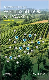
Vineyard monitoring is one of the most classical examples of sensor network monitoring. The goal is to reduce water irrigation and to predict or discover vine sicknesses as soon as possible. This not only minimizes costs of growing the vines through less water usage, but also enables organic growing with low usage of pesticides. Sensors used include air temperature, air humidity, solar radiation, air pressure, soil moisture, leaf moisture, ultraviolet radiation, pluviometer (rain sensor), and anemometer (wind sensor). The sensors are typically spread over a large area of the vineyard and deliver their information to an external database, in which the information is processed by special environmental models. The results are shown to the scientist or to the vineyard farmer and can be automatically connected to the irrigation system. Figure 1.2 shows a typical vine sensor node installed in a vineyard in Slovakia from SmartVineyard Solutions,1 a Hungarian spin-off company.
Figure 1.2 A sensor node from SmartVineyard Solutions installed in an organic vineyard in Slovakia. Reproduced with permission from SmartVineyard Solutions, Hungary.
A similar sensor network scenario is used for many other agricultural applications, often called precision agriculture. Examples are potato monitoring in Egypt [1], crop monitoring in Malawi [2], or a solution for vegetable monitoring on an organic farm in South Spain [3]. All of these systems have one problem in common: the foliage which develops over time. When the systems are first installed, the fields are almost empty or plants are small. However, as the crops grow, their foliage starts interfering with the system's work, particularly with its communications and sensors. Another common problem is that by harvesting time, the sensor nodes are well covered and hidden in the crops so their recovery is challenging. If unrecovered, they will most likely be damaged by the harvesting machines.
Bridge monitoring is a similar application in which the structural integrity of a bridge is monitored. Again, the space is limited, even if communication quality is better because of the outdoor, free-space environment. However, accessibility remains extremely limited.
There are two famous examples of bridges being monitored by sensor networks. The first example is tragic. On August 1, 2007, a bridge spanning the Mississippi river in Minneapolis collapsed suddenly under the weight of the rush hour traffic, killing 13 people and injuring another 145. The bridge was rebuilt shortly thereafter, this time equipped with hundreds of sensors to monitor its health and give early warnings.
The second example is more positive and presents the six-lane Charilaos Trikoupis bridge in Greece, which spans the Gulf of Corinth (Figure 1.3). It opened in 2003, with a monitoring system of more than 300 sensor nodes equipped with 3D accelerometers, tilt meters, tensiomag sensors, and many others. Shortly after opening, the sensor network signaled abnormal vibration of the construction's cables, which forced the engineers to install additional weights for stabilization. Since then the bridge has not had any further problems.
Figure 1.3 The Charilaos Trikoupis bridge in Greece, with a sensor network installed with over 300 sensor nodes. In its first days, it signaled abnormal vibrations, which could be quickly fixed. Source: Guillaume Piolle, Flickr.
Fire detection is crucial to save life and prevent damages. Sensor networks can be efficiently employed to detect fires early and send an alarm with the fire's exact position to fire brigades. This idea has been used worldwide in countries such as Spain, Greece, Australia, and Turkey. The main challenge with this application is the sensor node hardware itself and its resistance to high temperatures. It is quite inefficient if the sensor network designed to detect fires fails on a hot day or at the first sparks of a fire. For these reasons, robustness of the hardware and smart, over-provisioned network design are essential. Furthermore, typically large remote areas have to be covered, which can pose problems for installation, maintenance, and communication.
Tunnel monitoring is another way in which sensor networks are used. Road tunnels are dangerous all over the world. If something happens, such as an accident or a fire, it is essential to know how many people are still inside and exactly where they are located. Even in normal situations, tunnels are a danger by themselves, as the light outside often blinds the driver when exiting the tunnel. The TRITon project2


