Erhalten Sie Zugang zu diesem und mehr als 300000 Büchern ab EUR 5,99 monatlich.
- Herausgeber: BoD - Books on Demand
- Kategorie: Gesellschafts- und Liebesromane
- Sprache: Englisch
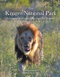
Why is South Africa's most famous reserve called the Kruger National Park? This book begins with that simple question and takes the reader on a captivating journey through history, wilderness and discovery. From the first European settlers at the tip of Africa to the trading days in the Lowveld, the narrative unfolds with the drama and beauty of a land that was once under threat and later transformed into one of the greatest conservation success stories in the world. At the heart of this transformation stands James Stevenson-Hamilton, the first ranger of the Sabie Game Reserve, who in 1902 began a lifelong mission to protect this wild land. His vision and determination led to the official proclamation of the Kruger National Park in 1926, a milestone that changed the future of African wildlife forever. Alongside him, the early rangers - isolated, fearless and deeply connected to the wilderness - shaped the spirit of protection that still defines the park today. But this is not only history. The book takes the reader on a guided safari, travelling northwards from the Crocodile River to the Limpopo. Each region and landscape is brought to life with vivid descriptions of its flora and fauna: lions stalking through golden grasslands, elephants moving silently among mopane trees, and rare antelope finding refuge along hidden watercourses. Ecological connections between rivers, plants and animals are explained with clarity, allowing readers to see the park not only as a collection of species but as a living, breathing system. Rich in detail, alive with atmosphere, and written with deep respect for the passion of rangers and visionaries who shaped it, this book is both a chronicle of the hundred years of Kruger National Park and a celebration of its enduring legacy. It is an invitation to experience the park as a place of wonder, memory and inspiration - where history and wilderness meet, and where the spirit of Africa continues to thrive.
Sie lesen das E-Book in den Legimi-Apps auf:
Seitenzahl: 787
Veröffentlichungsjahr: 2025
Das E-Book (TTS) können Sie hören im Abo „Legimi Premium” in Legimi-Apps auf:
Ähnliche


„I never knew of a morning in Africa when I woke up and was not happy”
Ernest Hemmingway
CONTENTS
INTRODUCTION
FIRST STEPS
SOUTH AFRICAN HISTORY
EARLY COLONISATION
THE CAPE BEFORE TIME
MODERN ARRIVAL
VOORTREKKER MOVEMENT
SCULPTURED HISTORY
THE MONUMENT TODAY
THE ANGLO-BOER WAR
NAMESAKE OF THE NATIONAL PARK
THE LOWVELD
INTRODUCTION
THE BLYDE RIVER CANYON
CONSTANT FORCE OF NATURE
A GOLDEN TIME
VISIT TO THE SUMMIT
GODS WINDOW
KADISHI AND BLYDE RIVER
TRADE TRAILS MEET MOUNTAINS AND SAVANNAH
ENVIROMENT
PRETORIUSKOP
THE VOORTREKKER ROAD
BERG-EN-DAL
MESSAGES ON THE WIND
HORN MEETS TUSK
DAILY LIFE OF GAME RANGERS
CONSERVATION STORYTELLING
PLAYTIME AT THE CROCODILE RIVER
GATEWAY OF RIVERS AND ROUTES
ALONG THE HEIGHTS OF MATJULU
MERCHANTS AND TRAVELLERS
SUNSET DAM - BIRD VIEWING
STALK AND FLIGHT
RAILWAY HISTORY
SELATI - CHALLENGES TO THE RESERVE
SELATI - RELIEF TO THE RESERVE
FORTUNATE GLIMPSE OF GREEN
COMPETITION OF PATIENCE
VIBRANT LIFE
FRUIT OF AFRICA’S SPIRIT
AFTERNOON SUN ON SPOTS AND MUD
HERITAGE AND HEART OF THE PLAINS
SABIE’S WATERS - SATARA’S PLAINS
BIOLOGICAL GUARDIANS
STRONGHOLD OF LIONS AND LEGENDS
THE ROAR OF ROMANCE
BEYOND THE BOUNDARIES
REPUTATION REMAINS INTACT
ECHOS OF THE PAST
ELEGANCE WITH A LONG NECK
PATIENT REPTILE
COLOURFUL EXPERTS
ADVOCATE OF THE PARK
PAINFUL ENCOUNTER
SWENI BY FOOT
RIVERS OF TIME AND WILDERNESS
PLAINS GIVE WAY TO RIVERS
RIVERBANK BLOSSOMS AND CURRENTS
AFRICA’S MAJESTIC TREES
PERCHED ABOVE THE OLIFANTS
FLOW OF A LIVING RIVER
RUSTIC SHORES TO RIVER CREST
CHASE ALONG THE LETABA
LETABA CAMP THROUGH TIME
ARCHITECTS OF THE SAVANNA
IVORY LEGACY
LONG TAILED COOKIE MONSTER
HIDDEN, SUBSTANTIAL WORKERS
BIOTOPE AT THE LETABA RIVER
RIVER OF TRADE AND FLOW
REFRESHMENT WITH A VIEW
EXPLOSIONS FOR A LIVING RIVER
CAPRICORN OVER MOPANE
MAKHADZI THROUGH TIME
LIFE OF A DELICACY
ON THE TSENDZE BANK
MOOIPLAAS - BUFFALO WORLD
TZENDSE BENEATH CAPRICORN SKIES
WHISPERS OF THE MOPANI KOPPIES
DOTS AMONG THE BRANCHES
DUST AND THIRST AT MOOIPLAAS
ALONG FORGOTTEN SURVEY LINES
BREATH OF THE SHINGWEDZI RIVER
RED ROCKS OF THE ANCIENT SHORE
STRIKING ENCOUNTER
GUARDIAN IN THE RIVER CANOPY
SHINGWEDZI - A PRIMEVAL DESERT
APPRENTICES OF THE HUNT
TRAILS OF IVORY, CURRENTS OF WILDERNESS
FOLLOWING THE MPHONGOLO
WATERS GUIDED THE CAMP
INSIDES OF ALIEN PLANT TREATMENT
FLICKERING TONGUES BY THE FIRE
THE IVORY TRAIL
LIFE AT THE LUVUVHU RIVER
A HUNTER'S PLACE FOR WILDLIFE
PAINTED PACK OF DIMBO HILL
SILENT BUILDERS
CLOSING THE GATES
EPILOGUE
APPENDIX
REGISTER
LIST OF BOOKS
FIELD GUIDES
REFERENCES
INTRODUCTION
Some places transcend mere landscapes; they stand as living witnesses to history, nature and the people who have shaped them. At the southern tip of the African continent, in the eastern part of South Africa, lies Kruger National Park. This park is a paradise for animal lovers and a testament to the dedication and PASSION of those who came before us and those who care for it today. It embodies a significant piece of South Africa's history.
This book emerges from a special partnership — a friendship that developed along the roads and trails of Kruger National Park. I have been travelling with Hendrik in southern Africa since 2007. In that year, Hendrik guided a safari that started in Cape Town and ended in Livingstone, Zambia. During this tour we visited the countries of South Africa, Namibia, Botswana and Zambia. After several more safari tours, mainly in Botswana, we took a group of friends from Germany to the Lowveld and the Kruger National Park in South Africa for the first time in 2014. We were eager to share the wonders of Africa with them. In the following years, we returned to the national park multiple times for extensive explorations.
We invite you to embark on an unforgettable safari adventure with us in the stunning Lowveld region. This journey involves the National Park and the surrounding area, which is vital to its wildlife and development. What began as a modest reserve has become one of the largest and most renowned wildlife sanctuaries globally, teeming with life and wonder. Immerse yourself in the rich tapestry of history that defines this captivating area, where every corner tells a story. Together, we will encounter remarkable individuals, passionate about wildlife, and explore the array of animals, majestic trees and vibrant plants that thrive in this breathtaking landscape. Prepare to be enchanted by the beauty and diversity that make the Lowveld and the Kruger National Park truly extraordinary!
FIRST STEPS
The Kruger National Park and its surroundings offer travellers a range of comfortable accommodation tailored to their needs. Outside the national park, various guest lodges are available, typically offering guided tours of the region's attractions and game drives into the park.
Overnight accommodation within the park varies from basic bush camps to larger main camps, offering simple tent stays to chalets. The main camps feature a petrol station, a restaurant, and shops. Guided tours are available in the morning and evening.
The Park and the camp facilities are managed by the South African National Parks (SANParks) SANParks is a public entity under the jurisdiction of the Ministry of Forestry, Fisheries and Environment. According to the National Environmental Management Protected Areas Act, SANParks represents and safeguards South Africa's biodiversity and its natural landscapes and seascapes. The goal is to create destinations for nature-based tourism that do not harm the environment. Currently, SANParks manages 19 protected areas covering a total area of 37,511 km2, which accounts for more than 3 % of the country's total land area. In comparison, national parks in Germany cover only about 2,000 km2or 0.6 % of that country’s area.
The changing seasons can be classified into two main periods throughout the year and influence the visits to Kruger National Park. The summers from November to April are hot and rainy. The game becomes widely lost in the park with increasing water availability in the rivers, natural lakes and higher water levels in the dams. The vegetation thrives during these months, transforming the savannahs into flowering grassland landscapes with dense, lush green forests and bushes along the rivers. The food supply for herd animals such as antelopes, buffalo, zebras, wildebeest and other herbivores is rich and nutritious in these months. It is, therefore, not surprising that the next generation sees the light of day in these months. The hunters of the savannah, such as lions, leopards, hyenas and wild dogs, await this time of abundance to raise their young. Sometimes, it is difficult to spot the cats. They often rest in the tall grass, hidden from us curious visitors.
The dry season from May to October is attractive precisely due to the dry landscape and excellent opportunities to observe large mammals. The water supply is concentrated in the rivers and a few water holes. Accordingly, the animal populations are dense around these sources of the precious resource. At the same time, the grass is lower, which reduces the number of hiding places for the hunters. We aim to explore the park at the climatic transition periods.
During my earlier visits to Africa, I must admit that the Kruger National Park was not my first choice for experiencing Africa's diversity and natural wonders. Initially, I viewed the national park as a symbol of mass tourism, while I sought solitude, intimacy and a personal connection with nature. In this regard, Botswana, particularly the Chobe River and Okavango Delta regions, was my preferred destination. Admittedly, I hadn't studied the history of South Africa and the Kruger National Park enough to make an informed judgement about the area.
There are various ways to explore the eastern part of South Africa. Tour operators offer planned group tours, with local guides accompanying travellers to overnight destinations and attractions. In recent years, the number of self-driving tours has increased. This option allows for a more personalised route, as the organiser helps participants plan their itinerary, including rental car use, accommodation, the number of overnight stays and sometimes guided day trips. Typically, these plans consist of a combination of established and curated travel components. For those who prefer a completely individualised experience, it is possible to assemble transportation, lodging and activities independently, booking each component separately. The internet, along with numerous booking platforms and the websites of rental vehicle and lodge providers, facilitates this kind of trip planning. Additionally, guided tours and excursions can often be organised on-site at short notice.
We plan and book our visits very individually. We choose a suitable vehicle, camping equipment and additional accessories to suit our destination. Therefore, the package is tailored to our destination, ideas and interests. Our visits to the Kruger National Park have varied in terms of our camps and the mix of main and bush camps. We vary the number of overnight stays based on the features and attractions of the respective region, allowing us to explore the areas extensively and discover the flora and fauna in all their complexity and diversity.
SOUTH AFRICAN HISTORY
The story of South Africa is one of movement, conflict, and enduring legacy. From the initial waves of colonisation at the Cape, new encounters and tensions shaped the land and its people. The Voortrekkers’ epic migration inland is honoured in the Voortrekker Monument and its detailed friezes, which depict the struggles and aspirations of the pioneers. Later, the Anglo-Boer War resulted in fierce battles and lasting scars, forging identities that still resonate today. Central to this history stands Paul Kruger, a symbol of resilience and leadership, whose name endures in the Kruger National Park—a tribute to both heritage and nature.
EARLY COLONISATION
Since the 15th century, European explorers, adventurers and merchants have sailed along the West Coast of Africa to establish trade routes to Asia and India. In 1488, the Portuguese explorer Bartolomeu Dias became the first to reach the continent's southern tip, sailing to Algoa Bay, near the present-day city of Gqeberha (formerly known as Port Elizabeth), before returning to Portugal in March of that year. His triumphant return and his reports about the possibility of passing the Cape marked the beginning of subsequent expeditions in the following decades.
In 1596, the first Dutch expedition arrived in the Far East, specifically in the islands that now make up Indonesia. After initial explorations and exchanges with the local populations, the Dutch established ports for sailing ships and trading posts in Sumatra, Java and Borneo. This establishment led to the creation of the colony known as "Dutch India," following the raising of the Dutch flag and the imposition of Dutch rule over the islands. The trade route between the Netherlands and the Far East required significant financial investment to build and maintain a sailing fleet. A single merchant family could not afford this cost, so on March 20, 1602, the East India Trading Company, known as the "Vereenigde Oost-Indische Compagnie" (VOC), was founded. The necessary funds were raised by issuing share certificates, making the VOC shares the first publicly traded shares. With these additional financial resources, the company could build ships, hire sailors, manage trading stations and recruit soldiers for protection. Since 1604, approximately 25 boats set sail for the East each year, trading valuable goods such as spices, coffee, tea, porcelain, carpets, gold and precious stones. Shareholders received dividends on their investments. Until its dissolution in 1798, when the Dutch crown took control of the colonies, the VOC conducted nearly 5,000 voyages from the Netherlands to Asia.1
On long sea voyages, provisions were a decisive factor, as food and water occupied a considerable part of the cargo hold, significantly limiting the amount of trade goods that could be transported. The longer and farther the ships travelled, the greater this tension between supplies and cargo capacity became. A significant relief and expansion of trade came with the establishment of supply stations along the route. They made it possible to set sail with fewer provisions on board and to replenish fresh supplies along the way. As a result, valuable storage space was freed up, which could now be filled with additional goods. In what is today South Africa’s Cape region, one of these supply facilities was established. The ships anchored in the bays of the region, and the crews went ashore in small boats to exchange provisions and fresh water for their journeys. In doing so, they also began to trade with the local population, despite the communication difficulties.
In 1652, the Dutchman, Jan van Riebeeck, established the first settlement at Table Bay on behalf of the VOC. Born in the Netherlands in 1619, he initially served as a ship's doctor on VOC vessels. Van Riebeeck's early travels took him to Indonesia and Japan, where he managed a trading station before being released and returning to the Netherlands. As expedition leader, Jan van Riebeeck reached the bay off Cape Town in 1651 with a crew of less than a hundred people on two sailing ships. At first, there were only a few huts and the first wooden houses. Here, he founded a settlement and had it reinforced with a fort. Today's Cape Town was the first permanent European settlement on South African soil. Fields were laid out to supply the incoming ships, and supplies and drinking water were stored. There were growing disputes between Europeans and locals in the first few years. The settlers increasingly moved into the hinterland and took over land. They crossed the Hottentot Mountains and reached the present-day regions around Stellenbosch, Swellendam and Mossel Bay. To them, the land seemed free, without an owner. But the Khoikhoi and San were nomads. For centuries, they studied the regions' seasons and the types of grass. The land and grasses determined the food supply for the livestock and the seasonal migration routes. Grasses that thrive in areas with fertile soils and higher rainfall are particularly sought. They are nutrient-dense and palatable, providing rich pasture for herds during the rainy seasons. The soft, succulent grasses form the basis of herders' prosperity during this phase of the year. Sedges thrive in drier, less nutrient-rich soils. Although these grasses become increasingly acidic and less nutritious during the dry season, they are essential for the survival of herds when traditional grasses are no longer available. While sedges are less appealing to livestock, they often represent the only available pasture during the drier periods. The nomads had to move their animals to these arid regions.
By the 17th and 18th centuries, nomadic lifestyles had become alien to the European settlers. They were settled and claimed permanent pieces of land. They erected fences and tried to manage the seasonal differences in soil yield by storing feed and fertilisers. This contrast in agricultural traditions can still be observed while travelling through South Africa; in rural areas, cattle graze freely along the sides of the roads, while European-based farms typically confine livestock to fenced pastures or stables. Tensions between the settlers and the Khoikhoi over land and livestock escalated, culminating in the first war in 1659. Although they were significantly outnumbered, the settlers' possession of handguns, rifles, and horses gave them a decisive advantage in the fighting, and they achieved victory. This technological edge influenced the dynamics of power for the next 400 years.
Between 1652 and 1662, Jan van Riebeeck bolstered the supply station and expanded agricultural practices in the region. Some of the plants he introduced continue to shape the agricultural economy in the Cape today. Van Riebeeck was also responsible for the first vineyards planted in the area, which led to the production of red wine known for combating scurvy. Cape wines have since gained international recognition and are exported worldwide today. Van Riebeeck and his family departed from the Cape Colony in 1662, returning to the Dutch East Indies, where he lived until he died in 1677. Many streets and squares in South Africa are still named in his honour today.
Aside from the early Dutch settlers, German and French immigrants settled in the area. The French Huguenots arrived from the Netherlands after fleeing religious persecution in France. Together with the Dutch and Germans, they considered themselves as a newly formed population group. Since the beginning of the 18th century, these immigrants with European roots who reached southern Africa from the 16th century onwards, have called themselves Afrikaners. Another significant group, the British settlers, arrived at the beginning of the 1820s to settle and farm in the Eastern Cape.
It is regrettable to note that the history of settlement in the 18th century is not the most glorious episode in the region and in South Africa. Battles for land and influence between the newcomers and the former natives marked this period. The number of cows and cattle measured the owner's wealth in this period. It was a bitter fight for these animals between the settlers, Khoi and Bushmen, who attacked each other. The climax was the almost complete destruction and expulsion of the Bushmen, also known as San, from what is now the Western Cape. A similar impact on indigenous peoples, known as the Indio tribes or the Aborigines, can be observed in other strongholds of colonisation in North America, South America and Australia during that period.
The Dutch language remained dominant, but mixed with other European languages and those of the indigenous population, a new language, Afrikaans, started to emerge. It increasingly separated itself from the original grammatical Dutch norms and became simplified. It can, therefore, be described as a Creole language that has developed from mixing at least two languages. This language development is often found in colonisation. Like Afrikaans, creole languages are frequently characterised by simple grammar and phonetic spelling. Afrikaans was not recognised as an independent language by the South African Parliament and enshrined in law until 1925, when it was listed as an official language.
To preserve the history of Afrikaans, with its roots in European languages and influences from Malay, Khoikhoi, and other African languages, the Society of "Real Afrikaners" was established in Paarl in 1875. The Society advocated for recognising Afrikaans as a distinct language rather than merely a dialect of Dutch. After a lengthy struggle that lasted 50 years, this classification was finally achieved. Plans for a monument in Paarl were first drafted in 1942, and in 1975, precisely 100 years after the foundation of the society and 50 years after Afrikaans was recognised as a language, the symbolic monument was unveiled during a grand ceremony.2 The monument is a sculptural structure constructed using regional materials that integrate seamlessly into the local granitic landscape. It features various tapering convex and concave forms that symbolise the diverse influences of different languages and cultures on Afrikaans. The ends of the columns and arches are intentionally left open, representing the ongoing evolution of the language. In summary, the Afrikaans Language Museum and Monument centres on Afrikaans but also serves as a platform to celebrate and understand the broader linguistic diversity of South Africa. Today, approximately 7 million people in South Africa speak Afrikaans as their native language, one of the country’s 12 official languages3.
Additionally, the unification of languages occurs in a prominent composition: the national anthem of South Africa. Since its adoption in 1997, it has represented the diversity of languages in the country and carefully combined selected stanzas from the songs "Nkosi Sikelel iAfrika" and "Die Stem" into one song. The first part is drawn from Nkosi Sikelel iAfrika, sung in Xhosa, Zulu and Sesotho, while the latter part incorporates Die Stem, sung in Afrikaans and English.4 Nkosi Sikelel iAfrika, originally a hymn composed by the Xhosa Methodist teacher Enoch Sontonga in 1897, became an anthem of the liberation struggle. The lyrics were widely sung in African languages such as Xhosa and Zulu. In contrast, Die Stem van Suid-Afrika was originally written in Afrikaans by Cornelis Jacobus Langenhoven in 1918 as a poem. M.L. de Villiers composed the melody in 1921. It was later translated into English and served as the official anthem during the apartheid era from 1957 to 1994.
A visual hymn to reconciliation, unity in diversity and the shared journey into a new era flutters in the wind at the official building. The South African flag unfurls in six vibrant hues—black, gold, green, white, red and blue—structured around a bold, horizontal "Y" shape that stretches from the hoist toward the fly. At the flag-pole side, a black isosceles triangle nestles against the staff, from which the green "Y" fans outward, its arms edged first in narrow white bands and then in broader gold stripes. Above the upper arm of the "Y" lies a gleaming red panel, while below its lower arm rests a deep blue field, creating a dynamic, forward-sweeping pattern that draws the eye—and the nation—toward a shared horizon. Born on April 27, 1994—the dawn of South Africa’s first fully democratic elections—the flag’s design, crafted by State Herald Frederick Brownell, bears no rigid official explanation of its colours; rather, its power lies in a tapestry of collective meanings. Black, green and gold echo the palette of the African National Congress, emblematic of the struggle against apartheid and the promise of political liberation. Red, white and blue recall the Dutch and British flags that once flew over the land, as well as the flags of the former Boer republics, acknowledging the threads of colonial and settler history. Above all, the converging "Y" symbolises the coming together of diverse peoples and traditions into a single, unified nation. 5
Constitution of the Republic of South Africa, 1996
National Flag of South Africa
THE CAPE BEFORE TIME
Travelling the Cape of Good Hope and the west coast of South Africa, it is difficult to imagine how wild this territory was in the days when the first settlers arrived. Today, cities like Cape Town and Stellenbosch, along with their suburbs, extend far into the flat hinterland and even up the hills. Leaving these areas further north and east, vast agricultural fields of wheat and maize can be found. Hedges and rows of trees rarely interrupt them. The land is dry, and the wind stirs up the dust. Dams form water reservoirs to irrigate the fields and make them fertile and spread over the country.
It was in March 2024 that I met Pippa while visiting the West Coast Peninsula. The West Coast Fossil Park offers an excellent opportunity to learn more about South Africa's early history. A guided tour and an information centre provide the details. While waiting for the tour to start, Pippa arrived at the open terrace with its view over the area and the excavation site. As we had coffee together, I was fascinated by her passion for the earliest history of southern Africa.
Pippa Haarhoff, Palaeontologist and Manager of the West Coast Fossil Park, can trace her family history back to the early days of the first European settlers in the 17th century. Her great-great-great-grandfather was from Hamm in Westphalia, Germany, and witnessed those times firsthand. If we could speak to him now, he would probably describe the country this way: “When I arrived in the bay in front of what is now Cape Town, the land was a wilderness. Only in a few places did sandy beaches permit landings with the dinghies. On the rest of the coastline, the waves broke on rugged rocks. Bushes, shrubby ericas, proteas and reeds lushly guard the shoreline. This is the coastal fynbos, as it is known today. The dunes were covered with robust, salt-tolerant plant species, including low-growing shrubs and ground cover of the genus Carpobrotus (sour fig). These are succulents with strong leaves. Inland, extensive shoals, strong shrubs and trees of Wild almonds (Brabejum stellatifolium) or Cape beech (Rapanea melanophloeos) line the rivers. Herds of antelopes, zebras, rhinos and elephants roam freely. Their well-trodden paths lead through the vegetation to their watering holes. Hippos frolic here. In addition to the herbivores, hunters such as lions, leopards and hyenas populate the vast plains and make our travels dangerous.”
During her archaeological studies at the University of Cape Town, Pippa Haarhoff developed her interest. She was fascinated by Earth's history from the very beginning. However, she only added palaeontology later when she was employed as a technical assistant in the Caenozoic Palaeontology Department in the South African Museum (now Iziko Museums) in Cape Town. Due to her interest in birds that developed as she grew up on her parents’ farm in Zimbabwe, she became particularly interested in the fossil bird collection from the Langebaanweg, an early Pliocene site in the West Coast Fossil Park. Her studies include the fossil mousebirds, stork, owls, eagles and vultures.
For 26 years, Pippa has been the Managing Director of the West Coast Fossil Park, located 20 km northwest of Langebaan. Declared a National Monument in 1996, the park opened to the public on September 22, 1998. Under Pippa's leadership, a visitor centre was constructed alongside scientific work, offering interested visitors insight into the work and the Earth's history. The excavation site is situated in an open-cast mine that has been extracting phosphate since 1943. Scientists became aware of the mine in the 195s when they were shown some fossil bones and teeth that had been collected by a miner and the first scientific paper was published in 1958 by Ronald Singer from the Anatomy Department of the University of Cape Town. The mining operations closed down in 1993 and the potential for establishing the West Coast Fossil Park was discussed and agreed upon by the South African Museum and Samancor mining company. A new fossil excavation was started in September 1998 by consulting archaeologists, Dave Halkett and Tim Hart, in collaboration with South African Museum palaeontologists, Roger Smith and Pippa Haarhoff. Instead of removing all the fossil material, the bigger specimens were left in situ for the purpose of becoming a site museum. Most of the larger bones in this excavation belong to an extinct species of Sivathere, Sivatherium hendeyi, named in honour of Brett Hendey who headed up the research on the Langebaanweg site during the 196s to the 198s when he was based at the South African Museum.
In addition to the prominent larger bones, the sieved sediments are examined for micro fauna including the remains of fish, frogs, reptiles, birds and small mammals such as golden moles, shrews and mole-rates. Fossil pollen samples have helped establish that the vegetation in this region was sub-tropical 5-7 million years ago. These remarkable scientific discoveries establish the Langebaanweg fossil site in the West Coast Fossil Park as a world-class excavation site. Palaeontologists use the fossil finds to reconstruct the palaeo-climate and ecosystems of ancient times to understand how the fauna and flora lived, evolved and died. The findings on the West Coast indicate that sea level, in relation to the Earth's land mass, has undergone significant fluctuations on multiple occasions over millions of years. Ice and warm periods alternated, and the amount of water trapped in ice surfaces at the polar caps varies considerably. This influenced the climate; erosive forces from the tides reshaped coastlines and shore zones, and rivers emerged, carving their way through the landscape. The flora and fauna adapted to these changes or perished as a result. This process also occurred in the Cape region. The fossil findings enable conclusions to be drawn about landscape development and provide an insight into the biodiversity of earlier times.
Currently, at the excavation site and in the new museum, fossil remains of ocean dwellers, land animals and species from transitional zones are on display, including an extinct African bear (Agriotherium africanum), a wolverine, as well as birds, amphibians and reptiles. The site is actually rated as one of the richest Miocene/Pliocene sites in the world with over 300 species so far recorded.
On land in the region today, you might still see a small antelope or a fox but no longer the larger wild animals that were present when the early European colonists arrived in the 1600s, unless you visit a protected area that has introduced some of the large mammals. Sadly, hunting has exterminated all these animals in the wild, with the last hippo being shot in the Berg River in 1869. As already alluded to, the fossil finds suggest that the vegetation was vastly different around 5 million years ago, and a greater variety of animal species lived here. It is of significant interest that all three different members of the giraffe family co-existed here. These include possible ancestors of the modern giraffe and okapi and the extinct Sivatherium hendeyi. In addition, the mega fauna included three species of elephant, rhinos, giant pigs, various species of antelope and dozens of smaller animals, such as aardvarks, foxes, mongooses, rodents and reptiles.6
The West Coast Fossil Park and the excavation site cover only a small area in South Africa and can be seen as a small window into the past that reveals part of the bigger puzzle of the history of South Africa. We are indebted to the dedicated researchers who devote much of their lives to improve our understanding of how life changes through time on this fascinating planet called Earth.
I am most appreciative of scientists, like Pippa, who not only offer a warm welcome during our visit to the park but also willingly share insight into her work and her passion for this remarkable site.
West Coast National Park,
fossilpark.org.za/gallery
MODERN ARRIVAL
OR Tambo International Airport, built on appropriated farmland, was established in 1944, in the Kempton Park area, east of Johannesburg. The site previously hosted a dairy farm and an eucalyptus plantation. Flight operations at the international airport began in 1952, initially named Jan Smuts International Airport. Jan Christian Smuts, born on May 24, 1870, in Riebeek West on the West Coast, was a South African statesman, philosopher, Boer general and British field marshal. He served as Prime Minister of the Union of South Africa during two terms: from 1919 to 1924 and from 1939 to 1948. Forty-two years after its original naming, the airport was renamed in 1994 to eliminate the political reference. Since then, it has been known simply as Johannesburg Airport. However, in 2006, the airport was renamed again to honour Oliver Reginald Kaizana Tambo (1917-1993), a prominent anti-apartheid activist and a key figure in the African National Congress (ANC).7
Depending on the departure point, European airlines arrive in Johannesburg early every morning after a flight of approximately ten hours. As the aircraft descends, the roofs of logistics companies in the Kempton Park industrial estate come into view, followed by the barrier fence and the asphalt runway. After landing, the distance from the runway to the terminal building is short, and passengers can soon exit the aircraft via the gangway. A staircase leads down from the gateway level. A queue forms at passport control in Terminal 1, but with many counters and immigration officials, the process moves quickly. Entry with a German passport is straightforward due to existing agreements, and a residence permit is issued for three months without needing a visa. While passengers handle the formalities at passport control, baggage service employees remove luggage from the aircraft and transport it to the terminal. The baggage belts at Tambo International are located directly behind passport control, where suitcases, bags and backpacks of various types and designs circulate on different belts, sorted by their airport of origin. Passengers arriving on the flight from Frankfurt gather at the designated belt and wait. Impatient and filled with anticipation, travellers assess each piece of luggage as it comes around, eager to identify their own. There is always a degree of tension until the question is answered: Did my luggage arrive intact and undamaged? I once experienced a delay in baggage claim on an early trip to southern Africa. It was in 2014 that our group of five travellers had four pieces of luggage left behind in Germany. Since we had planned a camping tour, the missing equipment posed a challenge. We had to change our plans at the last minute and opted to rent a bungalow for our first few days instead of pitching tents. This time, however, my luggage, a travel bag, arrived in South Africa on time. As usual, the customs checkpoint on the way to the exit was either unmanned or the officials were working discreetly in the background, avoiding attention. I exit straight into the airport's spacious central lobby, which features an open design and four floors. Drivers and tour guides stand ready to greet their guests, holding name and company signs. Hendrik will be in the lobby.
While his guests are going through the migration process, Hendrik prepares their pick as he explains his routine: “Today, I find myself in the expansive central lobby of Johannesburg Airport, a bustling hub that extends over four floors and accommodates a steady flow of travellers. Stefan will arrive this morning after a night flight from Frankfurt, Germany. The Johannesburg airport is divided into two main terminals, each serving distinct functions. Terminal 2 caters for domestic flights, allowing passengers a variety of journeys to cities such as Upington, Cape Town, Gqeberha or Durban without the need for passport control. The process of checking in is streamlined. Travellers quickly pass through security and make their way to the gates, thanks to the numerous daily connections that ensure a constant ebb and flow of aircraft and domestic passengers. In contrast, the International Terminal 1 is considerably more spacious and vibrant. Here, an impressive array of over 120 check-in counters awaits travellers who bustle about, handing over their luggage to airlines while collecting boarding passes and essential information for their upcoming journeys. Among the many shops and restaurants lining the terminal, travellers can leisurely pass the time, indulging in last-minute shopping for souvenirs or grabbing a bite to eat before their flight departs.
However, for my friend and guest, Stefan, the departure is still a few weeks off, allowing us time to embark on an adventure together. I am excited to explore the eastern region of my home country with him and expose him to South Africa's stunning natural beauty and rich, varied history.
As I glance around the lobby, I notice a flurry of drivers and tour guides assembling, eagerly scanning the crowd for their guests. They hold aloft signs displaying their tour company names or the names of the arriving passengers they are meant to meet. Fortunately, Stefan and I no longer require such signage. After numerous trips together, we have developed an unspoken routine, easily navigating the enormous hall. We instinctively head towards a quiet, secluded area in the rear of the lobby, from where we make our way to the parking garage. The airport has both a long-term parking garage and short-term parking spaces. Given the unpredictability of the immigration process, we prefer the parking garage for its convenience.
Together, we exit the airport grounds and set off towards the north, leaving the eastern outskirts of Johannesburg behind. As we drive, the landscape gradually transforms. Approaching the city centre of Pretoria, South Africa's capital, we catch sight of a striking, large building perched atop a hill just south of the city limits. Its impressive stature commands attention from a distance, setting the stage for our upcoming exploration. We will go and have a closer look at it.”
Terminal 1 Entrance, OR Tambo International Airport Johannesburg
VOORTREKKER MOVEMENT
The road leads to the foot of Monument Hill, named after the Voortrekker Monument, which sits on top of it. After registering as visitors at the gate, we follow the friendly security guard's directions to the visitor parking lot and information centre. A footpath leads up the hill. The park and the monument memorialise a significant era of colonisation in South Africa, honouring the Voortrekkers, Boer settlers from the Cape region who ventured inland in the 18th century in search of new settlements. Like many monuments, the Voortrekker Monument was constructed years after the events it commemorates. Paul Kruger first expressed his desire for a memorial in 1888 during the 50th anniversary of the Battle of Blood River, advocating for unity and independence among the Transvaal Republics. However, the decision to build the monument was not made until 1931.
Various designs from architects, sculptors and artists were submitted to the building committee in the following years. Gerhard Moerdijk, a South African architect from Pretoria with Dutch roots who studied in England and France, was awarded the contract to design this memorial. The monument's original design caused discussion in the press because it resembled an Egyptian temple. The architect visited Egypt and liked Egyptian history. He was asked to review his concept. The new design, the current monument, shows continued foreign influences compared with, for example, the Monument to the Battle of the Nations in Leipzig, Germany. The memorial is surrounded by a ring-shaped wall with ornaments on both sides. The decorations represent 64 ox wagons, which the Boers used to build their defensive fortifications during the Battle of Blood River on December 16, 1838. The wall is based on a competition design submitted by EC Pienaar and Ad Bouman. Therefore, the current site combines several designs submitted to the Voortrekker Memorial.8
The monument stands on an impressive square plan with a side length of 40 metres and rises 40 metres high. The central monument is built from granite blocks and reflects the revised design established in 1936. Statues of Andries Pretorius, Hendrik Potgieter, and Piet Retief on the corner pillars of the monument commemorate the prominent leaders of the Voortrekkers. On the fourth corner is an unknown leader sculpted to represent all the others Voortrekker. After construction began in 1937, the foundation stone of the Voortrekker Monument was laid on December 16, 1938, to mark the centenary of the fighting between the Boers and the Zulus. It took another 11 years until the ceremonial inauguration on December 16, 1949, attended by tens of thousands of visitors. Completing the monument with the interior depictions and the exterior with its statues took another 3 years, until 1952.
The Historical Trek Route Garden, redesigned in 2021, is an interactive garden that offers an exciting experience for visitors of all ages, not just children. Guests can follow the journeys of five notable leaders: Louis Trichardt, Hendrik Potgieter, Gerrit Maritz, Piet Retief and Piet Uys. Colour-coded paths wind through the garden, guiding visitors past informative boards and sculptures.9
We walk up a wide staircase to the central monument, pass through the ring-shaped wall and find ourselves on an intermediate level with well-kept lawns, individual trees, sculptures and water basins. We are in the fighting area, protected from arrows and spears by ox carts. Two side staircases take us to the base of the imposing granite structure. The entrance gate to the building is dominated by a buffalo head with curved horns. We enter the building and find ourselves in an open 25 x 25-metre hall covered by a 40-metre-high dome. A 27-panel marble relief frieze, at 92 metres, is on the walls of the Heroes' Hall at the visitor's eye level. The detailed depictions show scenes of daily life, crucial turns and stations of the Voortrekkers on their way from the Cape Colony to the northeast. The scientific study "From Memory to Marble", published in 2019 (Walter de Gruyter GmbH, ISBN 978-3-11-061522-7), discusses the frieze in detail.
The colonisation of today's South Africa began in 1652 when the Dutch East India Company founded the first settlement, Cape Town, on the southwestern tip of the African continent. Over the years, more adventurers came from Europe to find a new home in faraway Africa. By the end of the 18th century, the Dutch Cape Colony stretched along the southern coast beyond the borders of Cape Town.
In the early years of the 19th century, after disputes with the Dutch and the French, the British Empire increased its influence in the Cape Colony and finally gained the political upper hand. The Cape Colony was annexed in 1806. At first, the new British administration left the structures and regulations as they were, but this changed radically when more British settlers reached the Cape in 1820. The British authorities firmly rejected the Boers' ownership of enslaved people and what they considered to be the harsh treatment of the indigenous peoples. The indigenous people were granted the rights of "citizens" concerning security and property on an equal footing with the settlers. Furthermore, English was introduced as the sole official language in the judicial and political systems, even though most Boers spoke little or no English. The Boers felt excluded and disadvantaged, and the colony's white English, Dutch and French populations became alienated.
In the first wave, the Boer families left the initial Cape region and followed the coastline eastwards, identifying the land as a possible new colony; trek fever began to spread. The Cape Colony covered the area south of the Karoo between Cape Town and today’s Port Elizabeth. Dissatisfied with the political development in the Cape Colony, Boer settlers formed in the mid-183s in various places in the east of the colony, such as Graaff-Reinet, Uitenhage and Algoa Bay. Family groups joined the leaders such as Louis Trichardt, Hendrik Potgieter, Gerrit Maritz, Piet Retief and Piet Uys. They set out at different times from 1835 to 1838 and took different routes north and northeast to achieve independence from the British rulers. Their journey was arduous and involved hardship. There were no prepared paths for horse-drawn carriages or ox wagons at this time. Scouts had to find the best options and ways that allowed them to penetrate the dense vegetation, avoid mountains and hills and cross rivers. The paths of roaming animals like elephants served as indicators for possible routes. These did not lead through uninhabited regions. The treks encountered indigenous groups and tribes such as the Matabele and Zulu. Not every encounter was friendly. The presence and land seizure of those wishing to settle were perceived as threatening the indigenous people's way of life and culture, and conflicts and fighting inevitably ensued. The climax of the conflict was the battle on December 16, 1838, on the banks of the Ncome River, a tributary of the Buffalo River in the Zulu language. Subsequently, it became known as Blood River.
After the Zulu King Dingane had more than 500 Voortrekkers attacked and killed in their camp in February 1838, including Pieter Retief and his companions, Andries Pretorius and his followers set out to support the remaining Voortrekkers in the Retief trek. Together, they prepared a retaliatory expedition. At a strategically favourable location on the banks of the Ncome River, they built a wagon fort of 64 covered wagons and barricaded themselves behind it. They managed to provoke the Zulu to such an extent that they attacked the fortification. The Zulu were defeated despite the numerical superiority of over 10,000 warriors compared to 1,000 men on the Boer side. Only 3 Voortrekkers are said to have been wounded, while 3,000 Zulu warriors were killed and the fields and river were drenched in blood. Since then, the Ncome River was also called Blood River. The Zulu King Dingane fled and the Zulu power waned in the region. Pretorius' strategy and the superiority of firearms over shields and spears paid off. It laid the foundation for European settlement in the Natal area, east of the Drakensberg.
December 16th was celebrated as the "Day of the Vow" in South Africa. At the memorial at Blood River, there is a plaque with the words that Pretorius and his comrades are said to have repeated daily until victory. “We stand here before the Holy God of heaven and earth to make a vow to Him: that if He will protect us and deliver our enemy into our hand, we will celebrate this day and date every year as a day of thanksgiving like a Sabbath, and that we will build a house in His honour wherever He pleases, and that we will also tell our children to share in it with us for the remembrance of future generations. The honour of his name is glorified by giving him the glory and honour for the victory.”
Laying of the Voortrekker Monument foundation stone on 16 December 1938 Source:
From Memory to Marble Part 1, page
→
Voortrekker Monument, 03.2024
SCULPTURED HISTORY
The monument’s frieze has been part of Moerdyk 's interior design since the first drafts of the monument. The frieze depicts a selection of scenes from the departure of the pioneers in the Cape Colony, through the journey itself, the murder of Retief, the Battle of Blood River and the arrival on the eastern flank of the Drakensberg. The planning committee agreed on the individual content of the scenes in January 1937, understood to be the result of a letter to the Ministry of the Interior listing the scenes. The task now was to depict the chosen themes and scenes, find the artists to create the relief and involve them in the project.
Standing in front of the marble frieze, one is immediately captivated by the detailed and lifelike depictions of objects, animals and people. These depictions are based on drawings by Willem Hermanus Coetzer10, who was born in Tarkastad in 1900. In 1925, he moved to London to attend art school, funding his education by selling pencil sketches of famous artworks that he had studied in museums and galleries.
When Coetzer returned to South Africa and settled in Pretoria in 1933, he was given a special place to stay. For three weeks, he was welcomed at the home of Jan Christiaan Smuts at Doornkloof on Irene Farm in Pretoria.11 During this time, Coetzer enjoyed the privilege of using the library of the former Boer general and President of South Africa. While there, he began reading about the history of the Voortrekkers through the works of journalist, historian and writer Gustav Preller (1875-1943), which sparked his particular interest in Afrikaner history. After studying these books and writings on the Voortrekkers, Coetzer undertook expeditions along the historical routes, delving even deeper into the development of the nation. Inspired by history and his own experiences, he started depicting his impressions in his paintings and drawings, which may explain why he was able to capture the mood in his work. In early 1937, Coetzer was approached to create designs for selected scenes for the frieze. Several meetings were held with the memorial planning committee, and by February 1938, his pencil drawings illustrating the stories and scenic representations of the Voortrekker movement were finalised.
The invitations to the sculptors, Peter Kirchhoff, Frederik Johannes (Frikkie) Kruger, Laurika Postma and Hennie Potgieter, were sent out in March 1942. (From Memory to Marble Part 1, p. 187). Soon, on the 16th of the month, they were to bring their artistic and manual skills to bear and transform Coetzer's drawn scenes into a three-dimensional history book. (From Memory to Marble Part 1, p. 180). The artists' shared studio for the coming years was created in Harmony Hall, just as the architect Moerdyk wanted. Peter Kirchhoff, an immigrant of German descent, was older and more experienced than his younger Afrikaner colleagues. Under his leadership, the quartet aligned and standardized its working methods and styles to achieve a cohesive outcome. However, Harmony Hall was not always a place of boundless harmony. Ultimately, those involved were aware of their responsibility for this significant project to succeed. As a team, they worked together to fulfil the expectations for a coherent result. Today, the former Harmony Hall is at 137 Moerdyk Street, Tshwane. The outdoor facilities of the building, built in 1903 as a gymnasium by the German Gymnastics Association, provided ample space for creating the drawn scenes in clay and plaster.
Development of a Frieze panel in Harmony Hall, Pretoria, Voortrekker Monument, 11.2023
The project was divided into sections. In the first step, the sculptors created model figures and scenes as individual pieces. They then hired models who took on various poses and positions for the detailed depiction of people and animals. The models wore clothing and held objects or weapons from the time of the migrations. For the animal depictions, animals were borrowed and kept in the garden of Harmony Hall during this period. After producing the single-scene models, the sculptors enlarged the scaled-down models to the dimensions of the wall panels planned by Moerdyk. The enlargement led to countless significant changes in the layout, arrangement of individual scenes and pose and composition of the figures. The artists needed three years (1943–46) to complete this step.
Now, the time had come to bring the ideas to life. First, plaster casts of the reliefs were made. Whenever construction progress on the Voortrekker Monument allowed, the finished sections were transported to the construction site and set up in the Heroes' Hall. Kirchhoff tried to adapt the lighting in the Harmony Hall to the conditions in the Heroes' Hall to determine the overall effect of the scenes. Many photographs were taken.
A sculptor's studio in Florence, Italy, was chosen to create the marble frieze. In Italy, marble of the required quality was available, and the specialised Romano Romanelli workshop was experienced in producing marble sculptures of their own designs or copies of templates. They had developed processes and machines that made the work easier. Over 50 craftsmen were employed to carve the 92-metre-long frieze from South Africa out of the marble blocks. (From Memory to Marble Part 1, p. 259) Work in Italy began based on the photographs taken earlier, but restrictions during the post-war period led to significant delays in transporting the plaster models. The plaster panels took a long journey from Pretoria via the port of by sea to the Mediterranean port of Livorno and overland to Florence. In the meantime, the marble blocks were broken in the mine and cut into suitable slabs. When the raw material arrived at the Romanelli workshops, Postma and Potgieter were present for the start of work in Italy in January 1948. The two South African sculptors watched as their colleagues transferred the shapes to the marble and worked it with a hammer and chisel. In letters, they described how impressed they were by the skills, methodology and cooperation of the many employees in the workshop. The first finished marble panels were packed and sent to South Africa as early as May 1948. However, the production and delivery of the other parts of the frieze were then delayed due to increased costs. A fund raising effort was initiated to cover it. (From Memory to Marble Part 1, p. 268ff)
In the meantime, construction of the monument continued to progress. The building contractors started to plan how to transport the marble panels, which weigh between 2 and 10 tons, to their destination on the walls of the Hall of Heroes and how to place and attach them securely in position. In 1949, additional parts of the frieze were delivered, but they arrived damaged during transport. The transitions between the individual panels had to be reworked. (From Memory to Marble Part 1, p. 268ff) This work took time, and the opening day on December 16th was approaching. In December, the hall was prepared for the celebrations with great effort. The scaffolding and cranes were dismantled, and the Hall of Heroes was cleaned up to the last minute. It was not before April 1950 that the final parts were shipped from Italy, and the gaps in the 92-metre-long wall frieze were filled in. We can still view this work as a single unit today.
The marble frieze has developed from Coetzer's pencil drawings to sculptural art as we see it today in the monument. From small models, enlarged plaster models were created and finally carved representations in marble.
The herringbone pattern of the marble floor tapers towards the middle of the memorial hall. The rays originate from the hall's centre and spread to the sides. The visitor is drawn to the centre to a large round recess in the floor. We look at a sarcophagus-like marble block on the lower level of the monument. It is a cenotaph, a symbolic grave of the Voortrekkers who gave their lives on their way, especially Piet Retief and his followers. An engraving with the words "Ons vir jou Suid Afrika" adorns the capstone. It is a line from the Boer anthem "Die Stem van Suid-Afrika", the South African National Anthem until 1994. The line can be translated as "We for you, South Africa". We look up into the dome and through a recess. There, we see the blue South African sky. The positioning and orientation are designed so that on December 16th every year at precisely 12:00 noon, the sun shines through this hole and casts a beam of light onto the cover plate inside the monument. The beam of light is meant to symbolise God's blessing on the lives and efforts of the Voortrekkers. When the cornerstone was laid on December 16th, 1938, tens of thousands of people came to the hill to attend the ceremony. Even today, many visitors visit the monument every year on December 16th.
We descend into the burial hall using the staircase in one of the corner pillars. The cenotaph stands prominently in the centre of the hall. The walls are decorated with tapestries and paintings depicting the life situations of the Voortrekkers. In addition to life-size ox carts, we find everyday objects in display cases. A lantern has been placed in a niche in the north wall since 1938. The flame was lit at the cornerstone laying ceremony in 1938. Another staircase leads down to an exhibition area dedicated to the construction of the Voortrekker Monument itself. Through photos and videos, we learn more about the construction period and the days of the opening ceremony. The construction drawings are also shown, and you can leaf through them.
It was President Paul Kruger who, during his lifetime, wanted to build a memorial in honour of the pioneers. The handling and design of December 16 as a public holiday had been discussed for many years. In 1995, the day celebrated variously as Dingane’s Day, Day of the Vow and Day of the Covenant over the years, was declared a national holiday in South Africa, celebrated as a Day of Reconciliation to commemorate significant historical events for all peoples of South Africa.12
To conclude our journey back to the 19th century, we go to the viewing platform of the Voortrekker Monument. The path up the stairs leads us into the dome, which gives us a view of the memorial hall and the burial hall from above. The hole in the dome is close enough to touch. We take the opportunity to go out onto the terrace.
Once at the top, we can step out onto the parapet. To the north, we have a breathtaking view of nearby Pretoria. In the distance, to the south, we can see the skyline of the city of Johannesburg with several skyscrapers. Only 150 years ago, the cities of Pretoria and Johannesburg were small settlements. Today, they are the centre of modern South Africa. Settlers came here after an arduous journey on sailing ships and ox carts. Today, we can reach these places from Europe after just 10 hours of flying.
Hall of Heros, Voortrekker Monument, Preoria, 11.2023
Hall of Heros, Voortrekker Monument, Preoria, 11.2023
Cenotaph Hall, Voortrekker Monument, Preoria, 11.2023
THE MONUMENT TODAY
In modern South Africa, the Voortrekker Monument is viewed and interpreted in various ways. For some, particularly descendants of the Voortrekkers and so-called Afrikaners, it remains a proud symbol of their cultural heritage and identity. It celebrates their history and contributions to the country's development. However, for others, predominantly non-white South Africans, the monument represents an era of apartheid and oppression. It is seen as a reminder of the racial segregation and discrimination that deeply affected many lives. As a result, the monument serves as a historical landmark and a place for reflection on South Africa's complex and often painful past. Various initiatives have emerged in recent years to place the Voortrekker Monument within a broader historical context. Efforts are underway to present the monument as part of an integrated cultural heritage site that reflects the complete history of South Africa and the diversity of its people. Educational programmes and exhibitions aim to raise awareness of diverse perspectives and experiences while promoting dialogue about the monument's significance and the country's history. It has also become an important tourist destination for visitors from all over the world.
THE ANGLO - BOER WAR
To understand the current history of South Africa, it's important to glance at the war period for a moment.
The Anglo-Boer War, also known as the Second Boer War, was a pivotal conflict in South African history, fought between the British Empire and the two Boer Republics—the South African Republic (Transvaal) and the Orange Free State. It was rooted in profound political, economic and strategic tensions. At the core of the conflict was the British ambition to consolidate control over all of South Africa, partly to secure imperial dominance and partly to obtain access to the immense gold wealth discovered on the Witwatersrand in the Transvaal in 1886. This discovery transformed the region into one of the most economically valuable in the world and rendered it a strategic target for British expansion. Tensions escalated due to the growing population of English-speaking immigrants—known as "Uitlanders"—who had flocked to the Transvaal in search of fortune but were denied political rights by the Boer government under President Paul Kruger. The British, particularly High Commissioner Alfred Milner, demanded reforms, which the Boers resisted vehemently, perceiving them as a threat to their independence. Diplomatic negotiations, including the 1899 Bloemfontein Conference, failed to establish common ground. Earlier events, such as the 1895 Jameson Raid, a botched attempt by British-backed forces to incite a rebellion among Uitlanders, had already soured relations and foreshadowed the impending conflict.
War broke out in October 1899, with the Boers launching pre-emptive strikes and besieging key British garrisons at Ladysmith, Kimberley and Mafeking. The early months of the conflict were characterised by a series of British defeats, which became known as "Black Week" in December 1899. However, the tide turned in 1900 when Britain dispatched tens of thousands of reinforcements under the new commanders of Lord Roberts and, later, Lord Kitchener. The British relieved the besieged towns and captured the Boer capitals, Bloemfontein and Pretoria. Despite these setbacks, the Boers did not surrender. Instead, they resorted to guerrilla warfare, launching swift, mobile attacks under leaders such as Christiaan de Wet, Louis Botha and Koos de la Rey. In response, the British implemented a severe campaign of pressure to break Boer resistance. This included a scorched-earth policy in which British forces systematically destroyed Boer farms, homes, crops and food supplies. They constructed long lines of blockhouses and barbed-wire fences across the countryside to restrict Boer movement and support networks. Raids on Boer commando units and civilian communities became frequent. Most controversially, the British established concentration camps for Boer women and children, as well as for Black Africans caught in the crossfire. These camps were overcrowded and poorly supplied, resulting in outbreaks of disease and the deaths of tens of thousands, especially children. This brutal strategy succeeded in isolating the Boer fighters and eroding their will to continue the struggle.
Ultimately, with their resources depleted, the Boers agreed to peace. The Treaty of Vereeniging was signed on May 31, 1902, marking the conclusion of the war. The Boer republics were annexed to the British Empire but were promised eventual self-government, which they secured in the subsequent decade.
The flag on the Square June 5,1900,
With the flag to Pretoria Part 2, page 651
Peace Treaty of Vereeniging May, 31, 1902, public domain


