Erhalten Sie Zugang zu diesem und mehr als 300000 Büchern ab EUR 5,99 monatlich.
- Herausgeber: Birlinn
- Kategorie: Gesellschafts- und Liebesromane
- Sprache: Englisch
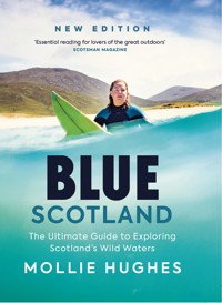
New and updated edition. Scotland is famed for its rugged coastlines, pristine beaches, endless rivers and deep lochs. The whole country is a magnet for outdoor enthusiasts from all over the world. In this unique guide, adventurer Mollie Hughes introduces many of her favourite places to paddleboard, kayak, swim and surf. Mixing world-class surfing breaks with kayaking adventures on the west coast, and urban paddleboarding along the Clyde with invigorating swims in the lochs of the Cairngorms, the book shows us how to access and enjoy these varied blue spaces. Mollie includes her own personal experiences and tips, enabling wild watersports fans of all levels to make the most of the amazing opportunities Scotland has to offer.
Sie lesen das E-Book in den Legimi-Apps auf:
Seitenzahl: 260
Veröffentlichungsjahr: 2022
Das E-Book (TTS) können Sie hören im Abo „Legimi Premium” in Legimi-Apps auf:
Ähnliche


This edition first published in 2025 by
Birlinn Limited
West Newington House
10 Newington Road
Edinburgh EH9 1Qs
www.birlinn.co.uk
Copyright © Mollie Hughes 2022, 2025
Photography copyright © Rachel Connolly 2022, 2025
Map on p. 17 copyright © Helen stirling (www.helenstirling.com) 2025.
Contains ordnance survey data
© Crown Copyright and database right 2025.
The right of Mollie Hughes to be identified as Author of this work has been asserted by her in accordance with the Copyright, Designs and Patents Act 1988.
All rights reserved. No part of this publication may be reproduced, stored or transmitted in any form without the express written permission of the publisher.
Every effort has been made to ensure this book is as up to date as possible. Some details, however, are liable to change.
The activities featured in this book contain an element of risk. The author and publisher cannot accept responsibility for any consequences arising from the use of this book. For more details on safety, see p. 223.
Maps featured in Blue scotland are for illustrative purposes only. For specific locations, please consult the os map, as suggested.
ISBN: 978 1 78027 922 0
ePUB ISBN: 978 1 78885 507 5
British Library Cataloguing-in-Publication Data A catalogue record for this book is available from the British library
Design and typeset by Mark Blackadder
Papers used by Birlinn are from well-managed forests and other responsible sources
Printed and bound by PNB, latvia
CONTENTS
Welcome to Blue Scotland
Blue health
Being a well-rounded adventurer
How to use this guide
Important notice and warning
Map
LOCATIONS
Edinburgh and surrounds
Cramond Island
Wardie Bay
Fidra Island
Belhaven Bay
Coldingham Bay
South Queensferry and the Bridges of the Forth
Kinghorn Loch
Loch Ore
St Andrews
Glasgow and surrounds
The River Clyde
Canals of the Central Belt
The Kelpies
Loch Lomond
Loch Long
Loch Ard
lake of Menteith
Loch Awe and Kilchurn Castle
Grey Mare’s Tail
Loch Ken
Blue Pools, Arran
Lamlash Bay, Arran
West Highlands
Loch Maree
Eilean Donan Castle and the Three Lochs
Loch Shiel and Glenfinnan
Loch Moidart and Castle Tioram
Arisaig Skerries
The Ardnish Peninsula
Loch Morar
Inner Hebrides
Kilnaughton Beach, Islay
Lagavulin Bay, Islay
Claggain Bay, Islay
Lussa Bay, Jura
Slate Quarries, Easdale Island
Fidden Beach, Mull
Eas Fors Waterfall, Mull
Calgary Bay, Mull
Iona
Tiree
Outer Hebrides
Vatersay
Castlebay and Kisimul Castle, Barra
Traigh Eais & Traigh Mhor, Barra
The Prince’s strand, Eriskay
Peter’s Port, Benbecula
Hosta, North Uist
Scolpaig, North Uist
Sollas, North uist
Scarista, Harris
Luskentyre, Harris
Huisinis, Harris
Traigh Mheilein, Harris
Traigh Ghearadha, Lewis
St Kilda
The North
Achmelvich Bay
scourie Bay
Durness
Strathy Bay
Thurso east
Dunnet Beach
Whaligoe Steps
Loch Ness
The North-east
Bow Fiddle Rock
Sandend Bay
Hell’s Lum, Cullykhan Bay
Aberdeen City Beach
Stonehaven and Dunnottar Castle
Lunan Bay
Central Highlands
Loch an Eilein
Loch Morlich
Loch A’an (Avon) – Cairngorms National Park
Linn of Tummel
Soldier’s Leap
Loch Leven, Burial Islands
Adventure planning & safety
Safety basics
Tides
Scotland’s Outdoor Access Code
Responsible and sustainable adventuring
Final thoughts
Acknowledgements
Index
WELCOME
WELCOME TO BLUE SCOTLAND
I grew up almost as far from Scottish blue spaces as you can get on mainland Great Britain. Until I was 18, I lived on the south coast of Devon in the seaside tourist hub of Torbay. But growing up there, with its crescent-shaped bay and its hilltops, from which you can look out to the horizon and the ocean, I was always connected to the bigger picture – to the rest of the world, and the wildlife that inhabits this blue space, its currents and swells.
When I was 13, we moved to a house close to the beach. When the wind blew strongly from the east, huge swells would enter the bay; on days like this, you could hear the roar of the ocean from my garden. The bedroom I shared with my sister overlooked the bay and if you were up early enough you could watch the sunrise over the ocean to the east. I think it was at this point in my life that I truly fell in love with the sea. I would spend hours marvelling at its changing moods – usually whilst I was meant to be doing homework or revising for exams. It was also around this time that I started surfing, heading further down the coast with my brother and dad to a beach called Bantham, or, when time allowed, to the north coast of Cornwall, for the bigger swells.
After I graduated from university, adventure took me far from the ocean, far from my small town in South Devon and far from sea level altogether. When I was 21, I joined an expedition to climb Mount Everest from the south side via Nepal. I had been climbing mountains for almost five years by this point and had spent my student loan on trips to far-flung mountain ranges around the world. I studied the psychology of Everest climbers for my final-year dissertation project at university before quickly deciding I didn’t want to just write about this mountain but experience the whole journey for myself. After a year of agonising training and sponsorship-hunting, a nine-day trek into base camp and six weeks acclimatising on the mountain itself, I finally reached the top of the world on 19 May 2012, alongside my Sherpa guide Lhakpa Wongchu.
When I returned to sea level, it took a while before I wanted to see another mountain again, but at 23 I moved to Scotland and began exploring this wonderful country from the tops of its highest mountains to its countless lochs and paradise-like islands.
Expeditions continued to take me far from Scotland’s shores, but I always returned with a smile, knowing that this rugged and wild country was home. In 2017, having just about forgotten the suffering of my first Everest expedition, I returned to the mountain, this time to climb from its northern Tibetan side. This route felt colder, windier, much more remote and much more technical. After another two months of acclimatising, my small team – consisting again of Lhakpa Wongchu Sherpa, with the addition of British guide Jon Gupta and Nepali Lila Tamang – reached the summit alongside me on 16 May. I became the first English woman to summit Everest from both its north and south routes, as well as, at the time, the youngest woman in the world to achieve this feat, at the age of 26.
A couple of years later, I took on my biggest expedition to date: I set out to ski from the edge of the Antarctic continent to the Geographic South Pole, a distance of over 700 miles. And I wanted to do this solo: no teammates, no guides, and unfortunately no Lhakpa Wongchu! It took me 58 lonely days to complete, during which time I experienced some of the worst weather on our planet, including huge windstorms gusting up to 50 knots, eight days straight of white-out where I couldn’t see more than a metre in front of my face, and temperatures down to minus 45°C with windchill. All the while, I was skiing uphill, pulling my 105-kilo sled, which I nicknamed Boudica.
I finally reached the Geographic South Pole on 10 January 2020 and entered the Guinness World Records by becoming the youngest woman to ski from the edge of the continent to the pole, at the age of 29. During these 58 days alone, I learnt so much about myself and what I am capable of, about the wild spaces on Earth and the fact that we are just visitors to this planet. We need to do everything in our power to enjoy it and preserve it.
I now spend much of my time as a motivational speaker, sharing stories from my expeditions. I am also one of the directors of an ethical adventure company called ocean Vertical. We take folk on adventures into the oceans and mountains of scotland, whilst doing all we can to protect this country’s remarkable wild spaces. I am an Asi paddleboard instructor and love nothing more than teaching people the key paddling skills. in 2020, I was given the honour of being asked to become the first female President of scouts scotland and to support this amazing organisation in preparing young people with skills for life, including a whole lot of adventure.
While researching and collecting photography for Blue Scotland, I had the opportunity to spend a year travelling to every corner of the country, exploring first-hand its mind-blowing blue spaces. The book’s photographer, Rachel Connolly, and i, often alongside our partners and various friends, travelled from the far reaches of scottish territory, such as the incredible st Kilda archipelago, situated in the middle of the Atlantic ocean, to inner-city blue spaces, including a sightseeing tour down Glasgow’s historic River Clyde. The diversity of natural spaces scotland has on offer still feels somewhat incomprehensible to me; the east coast differs so much from the west, even though they are separated by a matter of miles. Both are raw and captivating in their own ways.
Aside from the natural spaces, what inspired me most about this journey was the sheer number of small-scale, unassuming community-led projects dotted across the country, focusing on protecting the natural environment. Projects such as the installation of toilet facilities in beauty spots, funded solely by the efforts of locals; the presence of information boards linking travellers to the local wildlife and history of an area; the presence of waste disposal units to help avoid the littering of our green and blue spaces; and the community initiatives to protect damaged sand dunes and machair across the islands. Local small-scale environmental activism does work, and it is incredibly motivating to see so much of it across scotland.
Please use this book as an inspirational guide to explore some of scotland’s wild blue spaces, please marvel at Rachel Connolly’s stunning photography, and please do get planning your own adventures to embrace all that this incredible country has on offer.
Mollie Hughes
BLUE HEALTH
I am looking out over an endless blue horizon, with the sound of breaking waves on the shore, the rush of adrenaline when the first icy wave breaks over my head . . . I have always needed blue spaces. I am drawn to them when things get tough; they are a place to find some headspace, to be present, to explore and connect with the natural world.
For generations, people who have engaged regularly with blue spaces – be it via swimming, paddleboarding, surfing or simply walking alongside a body of water – believe them to have a psychologically restorative effect on the mind. They are often places of sanctuary and places to unwind.
The concept of ‘blue health’ is an emerging topic of study. There is a growing body of research that suggests outdoor blue spaces, which include the coast, lochs, riverways and canals, can have a huge benefit to people’s health.
Research has now unearthed evidence to support these beliefs – that there are significant benefits of time spent close to and in blue spaces for people’s mental health, general well-being and physical activity levels. The health benefits of time spent in green spaces are now well known and accepted; it is becoming widely accepted that the benefits of blue spaces may even outweigh those, in terms of reducing negativity and stress, as well as inducing a positive mood. It is now proven that bodies of water can have a psychologically restorative effect.
Scotland is famed across the world for its blue spaces: the country has so much to offer in terms of its rugged coastlines and pristine beaches, its endless riverways and deep lochs surrounded by towering mountains.
The Coast
Scotland’s 11,000-mile coastline wraps around the west, north and east of the mainland, as well as circumnavigating Scotland’s countless islands. The west of Scotland is characterised by the scarring of deep inlets up and down the coast. These sea lochs break up this mountainous terrain. The west coast is also home to the majority of Scotland’s outlying islands; the inner and Outer Hebrides are scattered over this far-reaching Atlantic shore.
In comparison, the north coast is shorter, wilder and more remote, open to (and at the mercy of) icy North Atlantic swells. Off Scotland’s frigid north coast lie Orkney, whose extensive sea cliffs are visible on a clear day, and roughly 100 miles to the north-east of the mainland, the remote and wild Shetland isles.
The east coast of Scotland is characterised by towering sea cliffs in constant battle with the power of the North Sea. Along this coastline you’ll experience long open stretches of sandy beach, quaint fishing villages, small towns and three of Scotland’s largest cities, Aberdeen, Dundee and the capital, Edinburgh.
The Lochs
Aside from sea lochs, Scotland is also home to 31,000 freshwater lochs. These range from small lochans to gigantic bodies of water – around 350 of them are of notable size. Freshwater lochs can be found throughout the country, from the southern Borders to the tip of the north coast, with the largest concentration being found in the Highlands. The most internationally recognised must be Loch Ness, which rose to fame in the 1930s after the first alleged photos of the infamous monster hit the newspapers. However, there is a lot more to Scottish lochs than mythical beasts; these vast bodies of water, along with Scotland’s rivers, contain 90 per cent of the UK’s fresh water, an incredibly vital resource for the whole ecosystem.
The Rivers
Snaking across the country, linking bodies of water to one another and the ocean beyond, are the lifeblood of Scotland, its riverways. Covering more than 7,000 miles, Scotland’s rivers and streams range from slow, trickling Highland burns to the vast, fast-flowing rivers of the Lowlands. The longest river in Scotland is the Tay, which flows from its source on Ben Lui for more than 100 miles to the Firth of Tay on the east coast.
The Canals
Scotland is also home to an extensive canal system, which covers more than 130 miles of navigable waterways. This includes the famous Caledonian Canal, which slices Scotland from west to east, providing a navigable channel across the country through the mighty Great Glen, and the Forth & Clyde and union Canals, which connect Edinburgh and Glasgow.
BEING A WELL-ROUNDED ADVENTURER
Scotland is an adventure playground for watersports enthusiasts. With so much variety in its blue spaces, you can literally do it all here. This book covers four main watersports: paddleboarding, kayaking, surfing and wild swimming. Entering blue spaces in Scotland is very much at the will of the weather conditions, the mood of our oceans and the water levels of our rivers. What I suggest is that being a well-rounded adventurer means that more conditions will be right for you to soak up some of Scotland’s blue spaces – there are a multitude of ways to access the water depending on the day. Often if the ocean is too calm for surfing, it could be good for paddleboarding. if it is too windy for paddleboarding, it could be good for sea kayaking. if your location is too inaccessible for carrying a kayak to the water, it could be good for wild swimming.
Paddleboarding
Paddleboarding is the world’s fastest-growing watersport. it has boomed in popularity over recent years. Paddleboarding gives you a new perspective on blue spaces – from your lofty position standing on your board, you can command your waterway, seeing far into the distance and deep into the water beneath your feet. Scotland has a magnitude of great places to paddleboard, from its coastlines to its fresh- and sea-water lochs, its riverways and its canal systems.
Kayaking
Sea kayaking is a wonderful way to cover large distances carrying everything you need for a day trip or even a week’s camping expedition. You can leave the crowds a long way behind and discover the hidden beauty of the Scottish coastline as you move silently through nature, experiencing wildlife up close and undisturbed while exploring hidden coves, cut-off beaches, remote inlets and caves you can only discover from the water.
Surfing
Surfing is one of the purest forms of enjoying a blue space. it involves catching and riding a breaking wave that has travelled across an ocean to crash on our shores. This sport has its origins in ancient Hawaii but began to gain popularity in Scotland during the 1960s along the east coast. There are countless places to surf on the mainland and the islands, from gentle beach breaks to world-renowned reefs.
Wild Swimming
Swimming is potentially the simplest form of engaging in a blue space. Very little equipment is needed, even though wetsuits and tow floats are often recommended. This sport has exploded in popularity during the last few years across the UK -who doesn’t know someone who has taken up wild swimming recently? Scotland is an incredible place to swim, from high-level lochs in the Highlands to stunning beaches along our coastlines, and riverways gently flowing out of the mountains en route to the ocean.
HOW TO USE THIS GUIDE
Blue Scotland is primarily an inspirational guide to some of my favourite blue spaces in scotland. Use this book to help you plan your own adventures – be it surfing, swimming, paddleboarding, kayaking or simply soaking up the blue-health benefits from the shore.
In order to maximise the value you get from this book, I have included definitions for a few of the key phrases that I have used to categorise each experience. You will find these ratings and definitions on each location page.
Activity
The watersport activity that can be undertaken at a location when conditions allow. includes swimming, surfing, paddleboarding and kayaking.
Experience level
A rating out of five to describe the level of experience you will need to undertake a certain route or enter a certain environment. The higher the experience level, the more time you should have spent honing your skill for the specific activity – and for these levels you should have undertaken the appropriate professional course.
Environment
The type of body of water on which an adventure is undertaken.
Carry time
How long it takes to walk from the start point to the water’s edge, based on a moderate pace and carrying a paddleboard, surfboard or kayak.
Public transport
Here will state if public transport is available from the nearest large town or city.
OS map
The Ordnance survey map number for each adventure location.
IMPORTANT NOTICE AND WARNING
Blue Scotland is a guide designed to provide information on watersport locations in Scotland and is not a substitute for your personal skills, knowledge and experience. in any watersport activity, there is an element of personal risk and risk to property.
Before you go out on any of these trips, you need to consider your skill level and have the ability to control your craft and rescue yourself in the environment you choose. it is recommended that you take watersport training classes with qualified organisations and individuals to gain the appropriate knowledge about safety, planning, tides, weather, personal skills, kit and the environment you will be entering.
EDINBURGH AND SURROUNDS
CRAMOND ISLAND
Activities
Paddleboarding, kayaking
Experience level
* * *
Environment
River
Start point
Cramond beachfront
Carry time
10 mins
Public transport
Bus connections from Edinburgh city centre
OS map
350
Cramond island is less than a mile long and consists of 19 acres of uninhabited land. its highest point is 68 metres above sea level and, from this unique 360-degree vantage point, you can look back at the city of Edinburgh, across to the Kingdom of Fife and up the Forth estuary to the famous Forth bridges.
As a tidal island it is only accessible, to most people, by foot at low tide. Tourists and locals alike have a short window to explore the island and walk back to the mainland before the sea rises and they, potentially, get very wet. However, while the landlubbers are restricted to the mainland, us paddleboarders and kayakers have the opportunity for an adventure. Cramond island is waiting for us during the high tide and a circumnavigation is a relatively short trip with the feel of a much bigger adventure.
There is ample parking along the road beside the Boardwalk Beach Club; alternatively, you can park in the Cramond beach car park at the most westerly end. Here you will find public toilets, as well as cafes and ice-cream stalls dotted along the shore.
I would advise starting your paddle to the island an hour or two before high tide. Once the tide turns, water rapidly drains out of this area and leaves behind a whole lot of mud, near impossible to wade through with a board or kayak. Additionally, the tide combined with the natural flow of the Forth can make for a strong current and a challenging paddle against the flow.
If you are in the mood for a little more adventure, you could head further upriver to explore the shoreline of the Dalmeny Estate. From this watery perspective, you get fabulous views of the impressive Dalmeny House and Barnbougle Castle, as well as the opportunity to explore a few quiet sandy beaches.
If for some reason you have ditched the paddleboards for the day and choose to walk over to Cramond island, there is an easy tool for you to check when it is safe to do so. You can text the word CRAMOND to 81400 to get safe crossing information texted directly back to you by the RNLI. Unfortunately, it is all too common for visitors to get stranded on the island with the rising tide, so plan your journey well and avoid any expensive and unnecessary call-outs from the emergency services.
This island paddle is reasonably accessible for competent paddlers who are confident in reading a tide timetable. But this trip gives the feel of a much bigger adventure when you are alone on the island at high tide looking back at the sprawling city of Edinburgh from your quiet island retreat.
WARDIE BAY
Activities
Swimming, paddleboarding, kayaking
Experience level
* *
Environment
River
Start point
Lower Granton Road
Carry time
2 mins
Public transport
Bus connections from Edinburgh city centre
OS map
350
Sitting between the ports of Leith and Granton, to the north of Edinburgh’s city centre, is a small sandy stretch and a wee slice of urban blue space. Wardie Bay is no more than 100 metres wide, and it certainly lacks the seaside holiday vibe of nearby Portobello beach, however this quaint space has its attractions, and is a draw for local paddleboarders and wild swimmers alike.
A long breakwater extends 800 metres around Granton Harbour, where you will often see anglers casting off their fishing rods and walkers strolling along on sunny afternoons. This breakwater creates great protection from the prevailing south-westerly wind at Wardie Bay and in turn creates somewhat calmer conditions for paddling and swimming in the sheltered waters close to the breakwater wall.
In recent years Wardie Bay has become a real hub for wild swimmers from Edinburgh – on a favourable day, you will see dozens of people, young and old, wetsuits and skins, entering the water. Even on a less favourable day you are still likely to spot one or two brave souls taking a dip. Many head in for a quick dunk, while others clad in wetsuits, swim caps and safety floats head out to take a lap of the nearby buoys. There is a wild swimming group that regularly meets here and a very friendly, welcoming vibe both in and out of the water.
In terms of paddleboarding, it can be a great beginner-friendly venue on a calm day. When I bought my first paddleboard, Wardie Bay was in fact the place where I headed to test it out. I pumped up the board on the small grassy area above the beach and to my utter embarrassment I didn’t set the valve correctly and all the air escaped very noisily – we have all been there, right?
From Wardie Bay you can head west up the Forth towards Cramond beach and island (see page 20), on to the Dalmeny Estate and even the Forth Road Bridges (see page 32), if you have the energy. Wardie Bay lies on the Firth of Forth, so do be aware of tides: water moves very fast in and out of the firth with the rise and fall of the tide. Always aim to swim on a rising tide; when paddleboarding, keep a keen eye on the wind speed and direction. Additionally, this can be a busy shipping lane at times, so whilst swimming wear a brightly coloured hat and/or tow float in order to make yourself known to other water users.
Access is very straightforward. Wardie Bay is on Lower Granton Road, where there are bus stops and limited parking outside the colourful cottages that line this stretch. Access is through a gap in the sandstone sea wall opposite the breakwater.
At first glance Wardie Bay may not look like much, but the growing community of enthusiasts who use this small space for their dose of blue health is intriguing and alluring. The local knowledge abounds, and the friendly atmosphere makes for a great urban blue space.
FIDRA ISLAND
Activities
Paddleboarding, kayaking
Experience level
* * * *
Environment
Ocean
Start point
Yellowcraig beach car park
Carry time
10 mins
Public transport
Bus connections from North Berwick to Dirleton
OS map
351
One of my favourite spots on the East Lothian coast is Yellowcraig, which lies 3 miles west of the seaside town of North Berwick. This expansive, sandy beach is a real gem and a popular spot for Edinburgh residents to escape the city on a warm summer’s day. During the training for my 2019 South Pole expedition, I spent countless hours dragging car tyres up and down this beach to replicate the sled I would be pulling in Antarctica – all the while wishing that I was on the water with my paddleboard Instead! However, the real paddleboarding adventure at Yellowcraig lies 300 metres off the shore.
Fidra Island is an RSPB nature reserve and home to several species of nesting seabirds, including puffins, guillemots, razorbills and even a peregrine falcon. It is claimed that Robert Louis Stevenson’s famous book Treasure Island was inspired by Fidra; he visited the island several times, it is thought, with his father, who was involved with the building of Fidra’s iconic lighthouse. For well over a century, this lighthouse has been warning sailors off the treacherous rocks that surround the island.
A circumnavigation of Fidra is an exciting but committing expedition which can be taken on by paddleboarders and kayakers. Conditions need to be near perfect, with minimal wind and swell. With this in mind, this trip should be reserved for those with more experience.
Once the island is reached, you can paddle around it in either a clockwise or anti-clockwise direction, depending on the wind and swell. it is always advisable to reserve the easier paddle for the homeward journey.
On the north side of the island there are several small, sheltered bays, perfect for a short rest or to observe the seabirds and resident seals. Do bear in mind that, as an important nesting site for many seabird colonies, it is advised not to land on the island or get too close to the cliffs where birds are nesting. Keep your distance and simply observe the wildlife in its natural environment.
Once the mainland is hidden from view by the island and the true extent of the bird life on Fidra is revealed, you begin to understand how amazing this wee island is. it feels remote, enchanting and wild.
This is an awesome small expedition with the feel of a big adventure, just a stone’s throw from North Berwick and within easy reach of scotland’s capital.
BELHAVEN BAY
Activities
Surfing, paddleboarding, kayaking, swimming
Experience level
*
Environment
Ocean
Start point
Linkfield car park or Shore Road car park
Carry time
10-15 mins
Public transport
Bus connections from Dunbar town centre
OS map
351
The rugged and rural East Lothian coastline extends from the edge of Edinburgh down to the Scottish Borders. Dotted with quaint seaside towns and villages, hidden coves and extensive sandy beaches, its unspoilt beauty makes it a haven for those seeking a dose of blue health.
When I first moved to Scotland from Devon, I was searching for a surfing beach within easy reach of Edinburgh; somewhere I could surf before work or visit to enjoy the long Scottish summer evenings. Belhaven Bay was the perfect spot. This beach lies about 30 miles east of Edinburgh and is an easy drive down the A1. Belhaven Bay is one of the most consistent surf beaches on the East Lothian coastline, picking up even the smallest of summer swells. it’s a popular spot with locals, tourists and those (like me) wanting to escape the capital. When the swell isn’t rolling in from the North Sea, Belhaven Bay can be a great place for wild swimming on a warm summer’s evening. An awesome paddle-boarding or kayaking journey can be taken between Belhaven Bay and Dunbar harbour, along an area called Long Craig Rocks, where you can weave in and out of the rocks and islands at low tide.
Belhaven Bay sits within the John Muir Country Park, a spectacular wildlife habitat made up of salt marshes, extensive sand dunes, pine woodland and, of course, golden stretches of beach. The park is named after the conservationist and explorer John Muir, who was born in Dunbar in 1838. John Muir lived in this seaside village as a child and no doubt his love for wild spaces began as he explored the beaches, forests and estuaries of Dunbar and its adjacent coastline. At age 11, John Muir and his family emigrated to the United States, where his life’s work protecting wild spaces across the pond began. It is quite humbling to enjoy the glow of his legacy as you walk through the salt marshes and sand dunes with your surfboard tucked under your arm.
There are two main parking areas to access Belhaven Bay. The first is Linkfield car park, adjacent to East Links Family Park. Here you will find a large paid parking area with toilets and even an outdoor shower, perfect for washing off boards and wetsuits after a surf. There is also a very cool-looking kids outdoor play park next to the toilet block. It looks to be the type of place I would have loved as a kid before I was interested in the ocean! From this car park you can follow one of the many faint paths through the salt marshes and sand dunes to reach the beach – wetsuit boots or wellies are advised, unless you like the squelch of mud between your toes.
The second parking area is in Belhaven village itself. It is a smaller paid car park on the ocean side of Shore Road, opposite the Belhaven Surf Centre. From here, you can cross the Biel Water to get to the beach; at low tide, take ‘the Bridge To Nowhere’ across the inlet. This famous bridge gets its name as at high tide only the bridge remains visible above the water, with no access to or from it.


