Erhalten Sie Zugang zu diesem und mehr als 300000 Büchern ab EUR 5,99 monatlich.
- Herausgeber: Luath Press
- Kategorie: Lebensstil
- Sprache: Englisch
Containing practical advice for visitors to what was once termed the 'Forbidden Isle', this comprehensive guide brings to the reader an idea of Rum's history, geography and geology, fauna and flora and culture.
Sie lesen das E-Book in den Legimi-Apps auf:
Seitenzahl: 287
Veröffentlichungsjahr: 2020
Das E-Book (TTS) können Sie hören im Abo „Legimi Premium” in Legimi-Apps auf:
Ähnliche


MAGNUS MAGNUSSON KBE, broadcaster and writer, is chairman of Scottish Natural Heritage, the government’s advisory body on environmental issues, which owns and manages the island of Rum as a National Nature Reserve. A lover of the countryside all his life, he was President of the Royal Society for the Protection of Birds (1985-89), and was chairman of the Nature Conservancy Council for Scotland (1991-92) before its merger with the Countryside Commission for Scotland to form SNH in 1992.
Known to millions as the television quizmaster of Mastermind throughout its highly acclaimed 25-year run, he also presented Tonight, Chronicle and Living Legends. He has written several books on archaeology and history (he was awarded the Medlicott Medal of the Historical Association in 1989), on his native Iceland (including Iceland Saga and Vikings!) and on his adopted country of Scotland (including Treasures of Scotland and The Nature of Scotland). He has also translated many of the classical Icelandic Sagas, and some modern novels by the Icelandic Nobel Prize-winner, Halldór Laxness.
In recognition of his many services to Scotland he was awarded an honorary knighthood (KBE) in 1989. He is also a Knight Commander of the Icelandic Order of the Falcon (1986).
First Edition 1997
eISBN: 978-1-913025-90-8
Reprinted 2006 and Reprinted 2012
The author’s right to be identified as author of this book under the Copyright, Designs and Patents Act 1988 has been asserted.
The paper used in this book is recyclable. It is made from low chlorine pulps produced in a low energy, low emissions manner from renewable forests.
Printed and bound by
Bell & Bain Ltd., Glasgow
© Magnus Magnusson
Contents
PrefaceMagnus Magnusson
IntroductionRoger Crofts
PART ONE: THE PAST
CHAPTER 1 In the Beginning
Rocks of ages
Volcano
From fire to ice
The island today
CHAPTER 2 The Coming of Man
Mesolithic findings
Neolithic and after
CHAPTER 3 Lords of the Isle
Early Christianity
Norse rule
The Macleans of Coll
The people
How they lived then
The Rum Clearances
CHAPTER 4 A Sporting Estate
The Salisbury years
The Campbell years
CHAPTER 5 Enter the Bulloughs
James Bullough (c.1800-68)
John Bullough (1838-91)
Sir George Bullough (1870-1939)
CHAPTER 6 Kinloch Castle
The making of the Castle
George and Monica
Inside the Castle
Edwardian heyday
End of an era
Family aftermath
Exit the Bulloughs
PART TWO: THE PRESENT
CHAPTER 7 A National Nature Reserve
What is an NNR?
The purchase of Rum
Getting to work
Warden/Naturalist
CHAPTER 8 Regeneration of the Woodlands
The restoration programme
CHAPTER 9 Rum in Flower
Flora of the woodlands
Maritime grasslands, heaths and marshes
Alpine flora
Pillwort
CHAPTER 10 Birdlife
Shearwaters: the Manxies of the Mountains
White-tailed (sea) eagles
Moorland birds
Seabirds
Woodland birds
Birds of the shore
CHAPTER 11 Red Deer on Rum
Deer research on Rum
Ageing
Food
Hummels
Life-histories
The cost of sons
Implications for deer management
CHAPTER 12 Ponies, Highland Cattle, Goats and other Mammals
The Rum ponies
Highland cattle
The goats on Rum
Other mammals
CHAPTER 13 Insect Life
Butterflies and moths (Lepidoptera)
Dragonflies (Odonata)
Beetles (Coleopatra)
Ants, wasps, bees, sawflies, ichneumon flies and allied insects (Hymenoptera)
Other insects and arthropods
CHAPTER 14 The Surrounding Seas
The undersea world
Survey
CHAPTER 15 Accommodating Visitors
The Forbidden Isle
Accommodation
Heritage Trails
Walks
The Cuillin Ridge
PART THREE: THE FUTURE
CHAPTER 16 Making it Happen
The Statement of Intent
Kinloch Castle
The cost
The island community
The community of the Small Isles
APPENDICESAIsland chronology
BDesignations
Acknowledgements and Sources
Maps can be found on pages 1, 3, 110 and 121
Preface
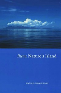
FOR FORTY YEARS NOW, the island of Rum in the Inner Hebrides has been in public ownership and managed as a National Nature Reserve. It is a marvellous national asset, owned and administered by Scottish Natural Heritage on behalf of the people of Scotland. This book tells the story of Rum, from earliest geological time to the present day.
It used to be called ‘Rhum’, not Rum; indeed, until relatively recently it was recorded by the Ordnance Survey as ‘Rhum’. No one now knows what its original name was. The earliest written record is in the seventh century Annals of Ulster, where the name was written as ‘Ruiminn’. There have been suggestions that when the Norsemen arrived in western waters they called the island Rømøy, meaning ‘Roomy Island’, but there is no documentary evidence to support this. A simple shortening of ‘Ruiminn’ to Rum seems more likely
As for the ‘Rhum’ spelling – that was a spurious late Victorian whim. Perhaps ‘Rum’ was felt to be rather a plebeian name for a sporting estate, or that it needed embroidery with some phoney Celticism by adding an ‘h’, on the ground that all Gaelic words seemed to contain an ‘h’ in every second syllable. In fact, Gaelic has no words beginning ‘Rh-’. Nonetheless, the last private owner of Rum, Sir George Bullough, was most insistent on spelling it ‘Rhum’ (perhaps because his wife, Monica, was a lifelong teetotaller!). When the island was ‘inherited’ by Scottish Natural Heritage in 1992, the old spelling was revived to bring it back into line with Gaelic usage, although it should more accurately be shown as ‘Rùm’ and pronounced ‘Room’.
The spellings of all the other Gaelic place-names in this book have been standardised in line with a comprehensive review undertaken on behalf of Scottish Natural Heritage in 1996 by Peadar Morgan of CLI (Comunn an Luchd-Ionnsachaidh), who regularised the orthography and established a correct form for each of the island’s place-names.
This book is a celebration of the 40 years of public ownership of Rum. To that end it tries to place the island’s story into the context of its geological origins and its human inhabitants and owners down the centuries. I can claim little personal credit for it – it is essentially a compilation of the work of others, a formidable array of experts who have laboured for years on the many fascinating aspects of Rum: its history, its natural history, its archaeology, all its life and earth sciences, in fact. They have generously allowed me to make unrestricted use of their published and unpublished endeavours.
I owe a huge debt of gratitude to them all, and their names are duly listed in the Acknowledgements and Sources. Suffice it here to highlight the major contributions, both general and particular, made by Martin Ball, John Baxter, John Morton Boyd, Tim Clutton-Brock, Roger Crofts, Martin Curry, Clive Hollingworth, Ben Leyshon, John Love, Peter Mackay, Alan McKirdy, George Randall, Michael Scott, Chris Smout, Chris Sydes, Des Thompson, Rob Threadgould, Michael B Usher, John Walters, Jeff Watson, Caroline Wickham-Jones and Peter Wormell, with special thanks to Iain Sarjeant for his line-drawings. I am also grateful to Elaine Dunlop, SNH Publications Manager, for her help with the illustrations, to Mary McNab, SNH Secretariat, for her sterling preliminary work on the Index, and to my secretary, Marion Whitelaw, for much patient work in tracking down contacts and checking vital facts and figures.
Magnus MagnussonKBE
August, 1997
Introduction
THE INTRODUCTION to any book on Rum, even by the Chief Executive of the body which owns the island, cannot be written in the dispassionate language of a management plan. For anyone who has visited Rum there is a sense of awe at the grandeur of the landscape, a sense of expectation of the wildlife to be seen and heard, a sense of curiosity about the secrets still locked in its rocks and landforms, a sense of sorrow at the impoverishment of the island and of its indigenous inhabitants before their unseemly clearance to Canada, and a sense of incredulity at the Edwardian transformation of it.
Driving through the native oakwoods of south Morar and Arisaig does not prepare one for the first sight of the Small Isles as one reaches the coast at Arisaig village. On a clear day the sentinel-like Sgurr of Eigg and the jagged peaks of the Rum Cuillin dominate the seascape and dwarf the rest of these islands; on a less clear day the helm clouds on the Rum Cuillin could easily be mistaken for the effusion from the great volcano which dominated the landscape some 60 million years ago. Mystery and allusions to past times abound. Passing through the Sound of Rum, with Eigg to starboard and Rum to port, the eastern flank of the Rum Cuillin towers above you and the coast looks severe and inhospitable. Turning into the haven of Loch Scresort, however, one enters another world: tree-clad slopes (the result of inspired initiatives by former owners) and the turrets of an incongruous castle built of alien stone.
As a geomorphologist by training, for me the real Rum is found in the very heart of the island. Standing on the Cuillin ridge one can see the island in its proper setting, with the Long Island hazy to the west and the other volcanic remnants looming to the north (the Skye Cuillin) and south (Ardnamurchan and Ben More, Mull). Close at hand are the magnificent exposures of banded stone which have stimulated the interest of so many geologists. On the western hills one marvels at the strange landforms for which Rum is rightly renowned.
Harris is an extraordinarily evocative place: a raised beach created by ancient waves which shaped large pebbles and dumped them high above the shore; the vestiges of the community of forty households of two centuries ago, eking out a subsistence living from the land; the vivid remains of one of the most extensive series of ‘lazybeds’ in Scotland; and the utter incongruity, in the setting of this abandoned crofting township, of the burial mausoleum of the Bulloughs, owners of the island for a mere 70 years. It symbolises the island’s long cultural history: the first recorded settlement in Scotland (at Kinloch), the changes of ownership, the development of crofting and its clearance in favour of sheep and then sport, and ultimately its acquisition by a Government nature conservation agency.
Similarly, the woodlands at the head of Kilmory Glen are symptomatic of a new, or at least a revived, world of humid West Coast woodland, with native trees and an abundant woodland flora and fauna. Walking through them now is an unforgettable experience.
The combination of cultural and natural history is one which has attracted visitors for years, despite the island’s former reputation of being ‘the Forbidden Isle’. Those who come to this Hebridean gem, whether scientists, climbers or tourists, seldom fail to come again, and again.
But despite all the efforts of our colleagues over the past 40 years, the ecology of the island is not what it should be: the gem is tarnished and has had some bits knocked off. On Rum we see the effects of millennia of misuse: the removal of trees and shrubs for fuel and for other domestic uses; the burning of the vegetation to increase its palatability (only to find that it was done far too frequently and probably too harshly, so that it left the soil impoverished); the effects of grazing and browsing by sheep, goats and deer to a point well beyond the carrying capacity of the land, and certainly to the detriment of the islanders who depended upon its produce. The gradually worsening climate over the last few millennia, with increased precipitation and lower temperatures, has certainly exacerbated the damage, further reducing the quality of the soils and the carrying capacity of the land.
No less significant for Scottish Natural Heritage as the owners of Rum is the poor state of the properties which survive from the Bullough era, particularly Kinloch Castle itself (see CHAPTER 6). Looking after historic buildings is no part of our natural heritage remit. Having failed to transfer these onerous responsibilities to a more appropriate guardian (see CHAPTER 16), we have been able only to keep the castle wind- and -water-tight; we have not yet been able to make any real progress towards making lasting improvements for the future.
Our legacy
This book rightly salutes the pioneers who made possible the acquisition of Rum, like Max Nicholson (then Director-General of the Nature Conservancy), John Arbuthnott (now the Viscount of Arbuthnott, who was the NC’s Land Agent for Scotland), and the late Joe Eggeling, the Nature Conservancy’s Conservation Officer (Scotland). It pays merited tribute, too, to the work of those who saw to the early implementation of the vision for Rum: Peter Wormell, the first Warden/Naturalist, and the late George McNaughton, the first Warden and, later, Chief Warden (CHAPTER 7).
The responsibility placed on the Nature Conservancy, the first of SNH’s predecessor bodies, was immense. The early Management Plans outline the primary objectives of ‘research aimed at recreating the natural characteristics of a Hebridean island’ (1960-64) and ‘to bring the island to a higher level of biological production than at present and one that can be sustained naturally by the environment’ (1965-69). The Plan for 1970-74 specified the objectives much more closely, gave scientific research a lower priority and heralded the importance of grazing by both domestic and native animals. The 1977-82 Plan, by the newly established Nature Conservancy Council (NCC), implied a broadening of the objectives to include education and public access.
The final revision of the management objectives for the Reserve by the Nature Conservancy Council for the period 1987/96 again summarised the guiding principles of restoration through management and manipulation of nature:
to allow natural development of the island ecosystem under the minimum management necessary to maintain and enhance nature conservation interests, the latter by habitat and species manipulation and restoration, to encourage use of the reserve by outside organisations for research (both applied and strategic) and for education, and to maintain the current level of public access.
Over the past 40 years some very significant achievements have been made:
· The successful establishment of 1050 hectares of woodland through the planting of more than a million trees, the vast majority grown in the tree nursery and latterly using seed from Rum sources (CHAPTER 8);
· the reintroduction of the white-tailed (sea) eagle (CHAPTER 10);
· the recording of the flora and fauna so that Rum is the best documented of all of the islands (CHAPTER 9);
· the successful undertaking of critical research on the volcanic complex (CHAPTER 1) and on the biology of red deer (CHAPTER 11);
· the encouragement of visitors both to learn about and enjoy the island (CHAPTER 15).
So the gem is on the road to recovery, and anyone arriving in Loch Scresort or walking the Heritage Trail on the north side of Kinloch Glen (CHAPTER 15) can see the beginnings of the transformation. Not only is the growth of trees and the arrival of woodland ground cover evident but also the birds and insects characteristic of woodlands have arrived.
SNH’s vision
SNH’s vision for Rum is in one sense simple: to improve the biological productivity and biological diversity of the island so that it contains the whole range of habitats and species which would naturally occur at the present time on a humid West Coast Hebridean island. That is a legitimate vision in its own right; and it will result in an increase in the carrying capacity of the island, so that we and our successors will be able to make choices about the level and type of human activity on Rum without ever again undermining its natural capacity. To achieve this vision is very challenging and very resource-intensive; it will take many decades, and require input from many others. The key words are the three Ps: productiveness, protection and people.
Productiveness
Our predecessors have demonstrated that the island’s biological productivity and diversity can be increased with the planting of trees to develop a woodland ecosystem. We have identified other areas where the remnants of a woodland flora are still present; this will help to inform our decisions on where to direct our future efforts at regeneration through planting, which in time will become self-sustaining. However, we are not concerned solely with woodland environments. Rum is of European significance for its wet heaths and its high montane habitats; we shall consider what is required in order to maintain and, where possible, improve their status.
One thing is abundantly clear: grazing and browsing pressure must be reduced. It is our intention to reduce progressively the number of red deer, probably by a half. This reduction will not undermine opportunities for studying the impact of herbivores on the habitats, nor for drawing out lessons from current research for application elsewhere in Scotland.
We are also considering increasing the size of our fold of Highland cattle. Their reintroduction in 1971 has been entirely positive in terms of habitat management of the herb-rich grasses of the Harris machair and in Kilmory Glen. With increased numbers we shall be able to ensure greater continuity of grazing in these areas and at other sites, such as Guirdil and Kilmory.
Rum’s herd of some 200 wild goats is a rather different issue. Goats are undoubtedly voracious browsers and can get to places, especially rocky ledges, which no other large herbivore can reach. SNH has to determine the balance between their impact on vegetation generation and the maintenance of semi-native animal communities.
With the progressive reduction in grazing pressure we shall start removing the fencing around the plantation enclosures. We believe that on Rum we should be able to demonstrate habitat regeneration through grazing management without the use of fencing.
Protection
SNH sees ‘protection’ as a positive concept. To us, protection means that the way in which the island is managed and used not only does not damage its natural interests but also, wherever possible, enhances their chances of development and the benefits they can bring to people. On Rum, as the chapters which follow admirably demonstrate, we have features of international and European significance, foremost among them being the Tertiary volcanic rocks of the main Rum Cuillin complex and of the western area, the periglacial landforms of the western hills, and the plants and birds of the wet heaths and the high hills. This collection of interests is protected through the island being designated as an SSSI for biological and geological reasons, as a Special Protection Area under the Birds Directive for its numbers of nesting seabirds (most notably the Manx shearwater populations and the breeding red-throated divers), and potentially as a Special Area of Conservation under the EU Habitats and Species Directive (most notably for its extensive Atlantic wet heath and a range of sub-montane and sub-maritime heaths and grasslands).
But perhaps the best way of indicating the importance of the island is to log its wildlife: 590 higher plant species, 374 mosses and liverworts, 352 lichens, 889 fungi, 202 birds, 12 other vertebrates, 64 crustaceans, 72 spiders and 2,158 insects of 17 orders have all been recorded in published checklists. All of these factors make protection of the natural heritage of Rum an imperative. Truly Rum is ‘Nature’s Island’; but it will never again become ‘the Forbidden Isle’.
People
We shall continue to encourage people to come to the island to study, to apply new thinking and new theories to what they observe and measure on Rum, to develop new ways of managing land with both people and the environment as beneficiaries. We want people to be able to learn from what the experts are discovering and thereby to become more knowledgeable themselves. We want people to enjoy to the full the experience of Rum: its natural and human history, its landscapes and its wildlife.
People should visit Rum to enjoy and to reflect, to walk and to climb, to paint and to photograph, to study and to research, to learn and to educate; but all these activities and many others must be compatible with the protection of nature and the achievement of greater biological productivity. The island must be managed within an ethic of environmental sustainability. This means that the vital assets of Rum – its rocks, soils, plants, animals and scenery – should be protected now so that they can continue to be used, studied and enjoyed by future generations in perpetuity. People should therefore look after Rum.
And people should live on Rum. For many years, nearly all the residents of Rum have been the employees, and their families, of SNH and its predecessor bodies. It is our intention to continue to have staff based permanently on Rum. We certainly do not intend to become an absentee landowner; but we would like the human community of Rum to be enabled to develop on its own. We recognise that many people see Rum, along with the other Hebridean islands and the adjacent mainland, as ‘the lost land’ whose indigenous population was sent overseas against its will. We anticipate that one of the outcomes of increasing the productivity of the land will be to create opportunities for others who are not in SNH’s employment to live and work on the island, and also for staff to be able to stay on and enjoy their retirement there (see CHAPTER 16).
We recognise that we must find a means of securing the cultural heritage of the island, especially Kinloch Castle and its contents. While this is not the statutory purpose of SNH, we recognise a responsibility to establish mechanisms which will protect that heritage, make it available for research and study, and make it available for the accommodation and enjoyment of visitors. We must also ensure that it is actively used, as we intend Rum to be a living island and not a museum.
Finally, we want the island and its people to develop closer relations with the other Small Isles, in step with the exciting developments on Eigg now that it is in community ownership. It is not our intention to compete with or mimic the activities on Canna, Muck and Eigg; but together we can promote new Hebridean initiatives which demonstrate that people and the environment can be interdependent for the benefits of both in the longer term.
Roger Crofts,
Chief Executive, Scottish Natural Heritage
PART ONE: THE PAST
CHAPTER 1
In the Beginning
Rocks of ages
THE ISLAND OF RUM is a volcano which died about 60 million years ago. That is an over-simplified way of putting it, but the ruin of that ancient volcano is what has given the island its unmistakably dominant profile among the Small Isles of the Inner Hebrides. The underlying story of Rum began long before the death of the volcano, however – some three billion years ago, in fact – and involves a remarkable journey across the face of the Earth.
For most of its life, much of what we now call Rum formed part of one of the many differently-sized plates which move slowly around the globe, part of a continent known to geologists as Laurentia; like many parts of the Highlands and Islands west of the major divide of the Moine Thrust, the ‘basement’ rocks of Rum are the hard crystalline Lewisian gneisses and associated rocks, formed almost 3 billion years ago. Some 800 million years ago it was lying in the centre of another supercontinent 30 degrees south of the present position of the equator. magmas welled up to make the land surface bulge into a dome shape, some 2,000 metres high. Subsequent reduction of magma pressure caused the dome to collapse, creating a huge central depression known as a caldera. This process, which caused a subsidence of some 2,000 metres, set off paroxysms of explosions and eruptions of hot ash and gas.
The ‘Parish of the Small Isles’
The escape of gases, and the catastrophic collapse of the caldera walls, generated rocks known as breccias. Made up of massive blocks, these now form the northern rim of the Rum Cuillin, including Coire Dubh, and much of the Ainshval and Sgùrr nan Gillean hills in the South Cuillin. The ash flows (perhaps similar in nature to those formed in more recent times on the island of Montserrat) settled in the caldera.
The intrusion of granitic bodies followed. They now form the western surface of Rum south of Fionchra and Bloodstone Hill. On Ard Nev the older Lewisian gneiss rocks are seen over the younger volcanic rocks, testifying that the latter cooled below the surface. The final episode of this stage was renewed uplift (of around 2,000 metres), which explains the position of rocks within the Main Ring Zone at Allt nam Bà. The boundary of this movement is a fault, known as the Main Ring Fault, encircling the Rum Cuillin.
The second stage in the volcano’s development was the formation of the spectacular layers of rocks which now form the heart of the Rum Cuillin and are especially prominent on Hallival and Askival. Sixteen alternating layers, each tens of metres thick, interleaved with thinner layers of only a few centimetres, created a remarkable rock sequence some 700 metres thick; the minerals in the rock were probably deposited by gravity, rather like sediments descending on to the floor of a lake. The very particular type found in the south-west, with a coral-like structure of a crystal called olivine, has been termed ‘harrisite’ after the old crofting township on Rum.
Taken together, all these activities created a broad and shallow-sided volcano (what geologists call a ‘shield volcano’) which is thought to have been 100 km wide and 2,000m high.
The remnants of the final stage of volcanic activity are best seen on the western hills. Here we find the only example in Britain (from this geological era) where the lavas are obviously younger than the central volcano; these are seen on Bloodstone Hill, Fionchra and Orval, where there are four lava flows which probably originated somewhere to the west of Rum. In the sub-tropical climate (as seen from soil horizons in some of the sedimentary rocks of the period) the main volcano lost its top and was quickly eroded by water. The rivers were strong enough to erode channels in the volcanic rocks to the west of the Cuillin, and in those valleys were dumped the rocks from the volcano itself. Here we find the ‘puddingstone’ rocks (rounded boulders set in sands: Over the aeons of time it wandered the southern hemisphere before drifting north across the equator. By the time it had reached its present position, 60 million years or so ago, the huge expanse which is now the North Atlantic Ocean was merely a narrow strait between present-day Greenland and the continent of Europe.
Rum: principal landforms
During its journey Rum experienced many different climates, and many different rocks were deposited. Perhaps the most significant of these periods was that time about 800 million years ago, when Rum formed part of a huge flood-plain crossed by wide shallow rivers. It was in this period that the ancient red-brown pebbly sandstone, named Torridonian after the Torridon area of the mainland, and other sedimentary rocks (notably shales), were formed. These rocks, some 4,500 metres in thickness, now comprise the low hills of the northern part of the island, typified by many benches separated by small escarpments; they also outcrop along the eastern and southern edges of the Cuillin.
There is then a huge gap in the geological story. With the exception of the terrestrial orange-brown sandstones of Monadh Dubh, and small fragments of the sedimentary rocks (seen at Allt nam Bà) laid down when much of Scotland was submerged under the sea, there is little in the visible rocks of Rum to tell us what was happening.
Volcano
A three-million-year volcanic period, some 60 million years ago, was crucial to the formation of present-day Rum. At that time this part of Scotland was an upland area, more than 500 metres high, covered with sub-tropical forests. It was a time of violent volcanic activity as the Earth’s crust began to stretch and the North Atlantic Ocean began to develop. All along the western seaboard of Scotland a string of volcanoes began to erupt – Arran, Mull, Ardnamurchan, Skye, St Kilda and Rum, which was one of the first.
The thinning and rifting of the Earth’s crust reduced the pressure on the solid rocks below and caused parts of them to melt, so that the liquid rock (magma) rose from depths as great as 100 km along cracks and vents in the crust towards the Earth’s surface. Some of the magma poured across the landscape as lava; examples of lava pre-dating the development of the Rum volcano, representing part of the Eigg and Muck lavafields, can be seen in the Allt nam Bà area.
Other magma cooled and solidified in the vents, and was exposed millions of years later as ‘dykes’ and ‘sills’, seen now especially in the northern part of Rum along the coast between Kilmory and Guirdil, and along the south-west coast between A’ Bhrìdeanach and Harris.
Three stages of the volcanic period have been detected on Rum, and each has made a distinctive contribution to the present landscape.
In the first stage in the development of the Rum volcano, granitic conglomerate) in the river valleys, and sandstones and finer-grained rock in the lochs.
The Rum complex of igneous rocks provides one of the best outdoor laboratories in the world for the study of basaltic volcanoes and the processes which form them.
From fire to ice
Over the next 50 million years after the Rum volcano had exhausted itself, its appearance underwent a transformation. In the warm, humid, sub-tropical climate the processes of erosion stripped away the top of the volcano and exposed its now cold, solid innards. In all, about a kilometre-depth of volcanic rock was removed. It was probably during this period that the volcanic rocks were also stripped from the northern part of the island to reveal the underlying Torridonian sandstone.
The next phase of Rum’s history was the Ice Ages. Over the last two million years it is likely that Rum was covered with ice sheets from the mainland on a number of occasions. It also experienced the development of local ice-caps and associated mountain glaciers. In between these ice periods there were periods of warmer climate. As far as we can tell, the erosional landforms reflect the cumulative effects of many glaciations, but the deposits we see today relate only to the last cold period, from about 115,000–10,000 years ago: they represent ice-sheet glaciation, mountain glaciation, higher sea levels than at present, and cold-climate frost weathering.
The ice sheet and its component glacier tongues moved across Rum from the mainland in a westerly and north-westerly direction. They exploited the softer rocks and the fault lines to deepen the main glens, especially Kilmory and Kinloch Glens; they scoured the bedrock, smoothing it and polishing it in places and leaving the landscape strewn with debris, including boulders of rock not found elsewhere on Rum. The effects of the erosion of the rocks by ice is best seen in the Cuillin: the grinding out of large hollows at the head of Glen Harris and Glen Dibidil, and the formation of small hollows or corries such as Coire nan Grunnd on Hallival and Coire Dubh on Barkeval. Deposits from the glaciers and ice caps cover much of the lower ground.
A final period of glacier activity occurred around 11,000 years ago – the time of the Loch Lomond Stadial and Re-advance (so named because the deposits it left were first identified at Loch Lomond). At this stage Rum probably had its own glaciers in the corries of the Cuillin and the western hills of Orval and Sròn an t-Saighdeir. This glacial period lasted for about a millennium and its effects are recognisable on the ground in the form of an outer ridge of moraines with more irregular hummocky moraines inside them, for instance in the corries of Sròn an t-Saighdeir and Orval, at the head of Glen Harris and in Coire nan Grunnd.
At the same time, a series of landforms representing cold-climate (periglacial) frost weathering was formed. Indeed, the western hills of Rum contain some of the most spectacular periglacial forms in the Inner Hebrides. Here we find the classic ‘patterned’ ground characteristic of periglacial areas, with the rock debris of various sizes sorted into regular shapes such as lobes, circles and ‘stripes’. Some of the periglacial landforms are still active.
The continued freezing and thawing in the cooler months, the steepness of the slopes and, particularly, the finer-grained material which makes it more susceptible to frost action, provide the perfect conditions for geomorphological activity today. Blocks of rock move slowly down the slopes until they build up so much soil and vegetation in front of them that they come to a halt; soil and vegetation also creep down the slopes in an irregular fashion and form terraces with banks of turf at their outer margin, while winds scour off the surface material. Not all the forms we see on the slopes today are created by frost action. In its exposed position, Rum has also a great deal of wind erosion, especially on exposed cols; the scars can best be seen on Ruinsival and between Barkeval and Hallival.
During the many periods of glaciation the western seaboard was pressed down under the enormous weight of the ice, and the sea-level at times was higher relative to the land than it is today. On Rum, shorelines were cut and beaches were deposited by wave action at different levels. Several such levels are found: a rock platform at about 20 metres above sea-level shows signs of having been scratched by ice action, and was possibly formed before the last glaciation at a time when the ice lay to the east of Rum; other shorelines formed as the last ice sheet melted (15–14,000 years ago) and also after the last Ice Age, about 7-6,000 years ago. It was at the latter time that the material which forms the present beaches on the island, including those at Loch Scresort and at Kilmory, was brought to the coast. At Kilmory the sand was subsequently fashioned by wind action into dunes and machairs, and at Harris very large shingle bars were thrown up by the waves.
The island today


