Erhalten Sie Zugang zu diesem und mehr als 300000 Büchern ab EUR 5,99 monatlich.
- Herausgeber: The History Press
- Kategorie: Sachliteratur, Reportagen, Biografien
- Sprache: Englisch
The Little Book of Suffolk is a repository of intriguing, fascinating, obscure, strange and entertaining facts and trivia about one of England's most colourful counties. It is an essential to the born and bred Suffolk folk or anyone who knows and loves the county. Armed with this fascinating tome the reader will have such knowledge of the county, its landscape, people, places, pleasures and pursuits they will be entertained and enthralled and never short of some frivolous fact to enhance conversation or quiz! A reference book and a quirky guide, this can be dipped in to time and time again to reveal something new about the people, the heritage, the secrets and the enduring fascination of the county. A remarkably engaging little book, this is essential reading for visitors and locals alike.
Sie lesen das E-Book in den Legimi-Apps auf:
Seitenzahl: 252
Veröffentlichungsjahr: 2013
Das E-Book (TTS) können Sie hören im Abo „Legimi Premium” in Legimi-Apps auf:
Ähnliche


CONTENTS
Title Page
Acknowledgements
Introduction
1. About Suffolk
2. The Military, Battles and War
3. Suffolk People – Famous and Not So Famous
4. That’s Entertainment
5. Suffolk at Work
6. Sense of Place
7. Crime and Punishment
8. Transport
9. Food and Drink
10. Myths, Legends and Curiosities
11. Sports Roundup
12. On This Day
Copyright
ACKNOWLEDGEMENTS
I would like to thank my friends for sharing their knowledge of and suggestions for subjects, and all those kind historians, staff and volunteers in museums, heritage centres and libraries across the county who have kindly helped me with my research. Particular thanks are due to Andrew Selwyn-Crome, Stewart P. Evans, Alan Murdie, Ivan Bunn, Chris Reeve, James Nice, Martin and Pip Faulks, Richard Blake, Sue Tod, Archivist at Felixstowe Museum, the Long Shop Museum, Leiston, Ipswich Museum, Moyse’s Hall Museum, Bury St Edmunds, Ron Carr and Tony Slatter at HMS Ganges Association Museum, Landguard Fort, Dr Stephen Cherry, Alan Kempton, Andy Jennings, Clare Baines, Jenny Phillips, Sophie Dunn, Michelle Bullivant, Robert Green, Treasure Chest Books, JC Books of Watton, the late John Timpson, Joy and all the Suffolk-born branch of clan Storey. And last but certainly not least, my mother Diane, my darling Molly and my son Lawrence.
INTRODUCTION
Suffolk is a very special county with rolling acres of mellow countryside and beautiful coastline, punctuated with many villages and towns of unspoilt charm and heritage. The county’s landscape, history, nature, skies, sunsets and people continue to inspire generations of artists, musicians and writers both born and bred or new to the county. To know Suffolk is to love it; the character of the county immerses both visitor and local alike, but how many people really know the county? This book does not pretend to be a history, concise almanac or guide; instead, it is a collection of the ephemeral, miscellaneous and quirky facts about Suffolk that you didn’t know you wanted to know until now.
Armed with this volume, the intrepid reader will be able to discover such gems of knowledge as:
Who was the man known as Bilious Bale?
What was Oliver Cromwell’s disembodied head doing at Woodbridge?
Where was the last invasion landing by foreign troops in England?
When was the first recorded race run at Newmarket?
How tall is the tower of St Edmundsbury Cathedral?
Why is there a house 60ft in the air at Orford Ness?
The contents of this book will enliven any conversation or quiz. It may even give pause to those who know and love Suffolk to say, ‘Well, fancy that!’
Neil R. Storey, 2013
1
ABOUT SUFFOLK
The name of the county comes from after the Saxons and Anglos divided Britain into kingdoms and the foundation of East Anglia in AD 575. Those in the north of the new kingdom were soon known as the North-folk and those in the south, the South-folk; this was soon corrupted to Suffolk. Although this name for the locality was in use for many years previously, the earliest written reference to Suffolk found to date was in AD 1045.
The administrative county of Suffolk covers 1,466 square miles.
Suffolk shares its borders with Norfolk to the north, Essex to the south, Cambridgeshire to the west and the North Sea to the east.
Suffolk is the most easterly county of England.
According to the Office for National Statistics, in 2011 the population of Suffolk was 730,100 and rated as the thirty-second largest county population in England. It has a population density of 192 per square kilometre and ranks as the thirty-eighth county for population density.
The county of Suffolk covers 1,467 square miles and ranks as the eighth largest ceremonial county of England.
At its greatest length, Suffolk is 52 miles across.
At its greatest breadth, Suffolk measures 48 miles.
Much of Suffolk is low-lying and founded on Pleistocene sand and clays. It is only the west of the county that stands on the more resistant Cretaceous chalk.
The soil of Suffolk varies, but a strong loam on clay marl bottom, ideal for agriculture, predominates throughout the county.
The Red Crag geological deposit reaches a depth of 147ft at Southwold.
The highest point of the county is Great Wood Hill, on the Newmarket Ridge near Rede. It has an elevation of 420ft.
Lowestoft is the most easterly town in the county and therefore the United Kingdom.
Ness Point, also known as Lowestoft Ness, is the most easterly place in the United Kingdom.
The Suffolk coastline is mostly bordered by heathland known as the Sandlings.
The Suffolk Coast and Heaths, an Area of Outstanding Natural Beauty, stretches over 60 miles from Kessingland to the Shotley Peninsula, and encompasses 155 square miles of wetlands, heaths, beaches, towns and villages.
Alton Water Reservoir is the largest area of inland water in the county. Opened in 1987, the construction work and completion took thirteen years. The pumping station and water treatment works below the dam is capable of treating 10 million imperial gallons of water a day.
In 2005, there was a discovery of flint tools in the cliffs at Pakefield, and as a result the human habitation of the Lowestoft area can now be traced back 700,000 years.
When the Orwell Bridge was opened in 1982 it was one of the largest pre-stressed concrete structures in Europe.
The Port of Felixstowe is the largest container port in the United Kingdom.
In 1929, there were a total of 503 civil parishes in the county of Suffolk.
The parish of Dallinghoo Wield, which covered just 34 acres, was claimed as the smallest parish in England until 1980 when it was declared an anachronism by the boundary commissioners and abolished as a parish in its own right.
East Suffolk, West Suffolk and Ipswich were merged to form the unified county of Suffolk on 1 April 1974, under the Local Government Act 1972.
Today, Suffolk is divided into seven districts: Ipswich, Suffolk Coastal, Waveney, Mid Suffolk, Babergh, St Edmundsbury and Forest Heath.
SUFFOLK HUNDREDS
Historically, Suffolk was divided into two divisions, East and West, containing the following hundreds:
Eastern Division: Blything, Bosmere and Claydon, Carlford, Colners, Hoxne, Loes, Mutford and Lothinghland, Plomesgate, Samford, Thredling, Wangford, and Wilford.
Western Division: Babergh, Hartismere, Stow, Blackbourn, Cosford, Hartismere, Lackford, Risbridge, Stow, Thedwestry, and Thingoe.
THE RIVERS OF SUFFOLK
The River Alde has its source at Lawfield, near that of the River Blyth. It becomes tidal at the village of Snape and runs to the east of Aldeburgh, after which this part of the river takes its name.
The River Alde becomes known as the River Ore as it approaches Orford, where it once entered the sea. The mouth of the river is now a further 5 miles south.
The River Blythe has its source at Laxfield and a tidal estuary between Southwold and Walberswick. The Blyth Navigation canal was opened in 1761 and ran a total of 7 miles from Halesworth to the Blyth estuary. It became insolvent in 1884, was used occasionally until 1911 and was formally abandoned in 1934.
The River Deben rises in Debenham, runs through Woodbridge and turns into a tidal estuary before entering the North Sea at Felixstowe Ferry.
The River Dove is a tributary of the River Waveney, which starts at Horham and runs through the market town of Eye to the Waveney.
The River Gipping rises near Mendlesham Green and flows through Stowmarket, Needham Market and on to Ipswich, where it becomes the River Orwell. The old Ipswich and Stowmarket Navigation canal, opened in 1793, was achieved by the construction of some fifteen locks. It closed in 1922.
The River Kennett rises to the south of Dalham, flows through Moulton and Kennett, and joins Lee Brook, a tributary of the River Lark, south of Freckenham. The River Kennett usually runs dry in the summertime.
The River Lark is a tributary of the River Great Ouse. It rises at Bradfield Combust near Bury St Edmunds and flows through Bury, Mildenhall and across the Cambridgeshire border into Prickwillow and on to join the River Great Ouse south of Littleport.
The Little Ouse is a tributary of the River Great Ouse, and rises near Thelnetham and flows through Rushford, Thetford, Brandon and Hockwold before it joins the Great Ouse north of Littleport. The Little Ouse is also used to delineate part of the border between Norfolk and Suffolk.
The Minsmere river is formed out of the River Yox at Yoxford and flows through Middleton, Eastbridge and on to the Minsmere New Cut (built in 1812) and reaches the sea at Minsmere Sluice.
The Butley river, otherwise known as Butley Creek, has its source in Rendlesham Forest and is tidal from its confluence with the Ore at Boyton, and goes as far inland as Butley Mills and Butley village. The Butley Ferry, run by the volunteer ferrymen of the Alde & Ore Association, crosses the Butley Creek river and provides a link for pedestrians and cyclists between Orford, Boyton and Butley between Easter Saturday and September every year.
The River Ore is the name given to the final section of the River Alde from just above Orford until it joins the sea. It has one tributary, the Butley river, and Havergate Island is to be found at their confluence.
Oulton Dyke is about one mile long and connects Outon Broad to the River Waveney.
The River Waveney has its source near Redgrave and flows through Hoxne, Needham, Weybread, Homersfield, Earsham and Bungay, Beccles, Soerleton and over the border into Norfolk, where it flows through Haddiscoe, Breydon Water and out into the North Sea at Great Yarmouth.
The River Rat has its source at the village of Rattlesden and is the major tributary of the River Gipping.
The River Brett has its source near Lavenham. It flows through Hadleigh, Monks Eleigh, Brent Eleigh and Chelsworth to its confluence with the River Stour.
The River Orwell has the River Gipping, above the tidal limit at Stoke Bridge, as its source river. The Orwell broadens into an estuary at Ipswich, joins the River Stour at Shotley and flows into the North Sea at Felixstowe.
The River Stour rises in Eastern Cambridgeshire, flows east of Haverhill and through Cavendish, Bures, Sudbury, Nayland, Stratford St Mary and Dedham Vale. The Stour becomes tidal just before Manningtree and joins the North Sea at Harwich. It also forms most of the county boundary of Suffolk and Essex.
Stour Brook begins to the west of Haverhill and soon joins the River Stour near Wixoe, Essex.
The River Yox flows from the west of Peasenhall through Sibton and Yoxford, where it becomes the Minsmere river.
The Lark and the Little Ouse are the only notable Suffolk rivers that do not flow directly to the sea.
THE LOST TOWN OF DUNWICH
Through the years, the erosion of the county’s soft cliffs and encroachments by the sea along the East Coast have caused the loss of hundreds of acres of land, and a number of settlements, including Covehithe, Pakefield, Aldeburgh and Slaughden, have all suffered from the loss. The hamlet of Newton has completely disappeared, but the most famous and important of all was the loss of the flourishing port town of Dunwich.
The decline of Dunwich began in 1328, when a tempest hit the coast and the hurricane-force winds drove the sea against the spit of land known as the King’s Holme and pushed it into the harbour area, effectively rendering it impassable. All trade and revenues simply moved to Walberswick and left Dunwich to rot. Four hundred houses, along with shops, barns, windmills and two churches, St Martin and St Leonard, fell in the maelstrom. By the early twentieth century, all of the other churches and chapels eventually succumbed to the sea, as did most of the town. Despite the decline of the town they still maintained the ancient right to return two Members of Parliament. By the time of the 1832 Reform Act, there were only eight residents left in the constituency!
THORPENESS
The village of Thorpeness was a sleepy fishing hamlet until wealthy Scottish barrister G. Stuart Ogilvie bought the area and built a private fantasy holiday village in mock Tudor and Jacobean styles, where he invited friends and colleagues to stay during the summer months. He even created a shallow boating lake he called the Meare, with several coves and landings marked with names on a Peter Pan theme (author J.M. Barrie was a personal friend of Ogilvie and his family). Little islands on the Meare also contain locations inspired by the novel, such as Wendy’s home, the pirates’ lair and many others, where children are encouraged to play. The old crocodile still lurks around the place too! The outstanding feature of this dreamland of Thorpeness is its water tower, disguised as a five-storey clapboard house with imitation windows and a pitched roof 60ft up in the air. Ogilvie named it ‘The Home of Peter Pan’, but tenant Mrs Malcolm Mason loved it so much she was inspired to write the poem ‘The House in the Clouds’, and the name stuck.
SOME OF THE LESSER KNOWN MUSEUMS AND HISTORIC SITES OF SUFFOLK
Bawdsey Manor RADAR Transmitter Block, Bawdsey
Bentwaters Cold War Museum, Woodbridge
British Resistance Organisation Museum, Parham Airfield
Centre for Computing History, Haverhill
Clifford Road Air-Raid Shelter, Ipswich
Felixstowe Museum in the old Submarine Mining Establishment near Landguard Fort
Greene King Brewery Museum, Bury St Edmunds
HMS Ganges Museum, Shotley Marina, Shotley
Laxfield & District Museum, the Guildhall, Laxfield
Long Shop Museum, at the old works of Richard Garrett & Sons engineers
Lowestoft and East Suffolk Maritime Museum, Sparrow’s Nest Gardens, Lowestoft
Lowestoft War Memorial Museum, Sparrow’s Nest Gardens, Lowestoft
Martlesham Heath Control Tower Museum
Mechanical Music Museum, Cotton
Mincarlo, sidewinder fishing trawler museum ship, Lowestoft
Museum of Knots and Sailors’ Ropework, Ipswich
Packhorse Bridge, Moulton
Royal Naval Patrol Service Museum, Lowestoft, Sparrow’s Nest Gardens, Lowestoft
Ruins of Leiston Abbey (founded 1182)
Southwold Sailors’ Reading Room, East Cliff, Southwold
St James’ Chapel (built about 1250), Lindsey
Suffolk Underwater Studies Museum, Orford
Suffolk Heavy Horse Museum, Shire Hall, Woodbridge
The Amber Museum, Southwold
The ruins of the great church at Covehithe
Woodbridge Museum, Woodbridge
THE HEIGHTS OF IPSWICH
In 1930, the highest structures of Ipswich were recorded as:
St Mary’s Church tower
176ft
Ipswich Electric shaft
176ft
St Peter’s Church tower
93ft
St Lawrence’s Church tower
90ft
Spring Road Viaduct
61ft
SUFFOLK LIGHTHOUSES
Lowestoft (High), current structure built 1874, station established in 1609. A white flash every fifteen seconds.
Lowestoft North Pier, built 1847. Green light: four seconds on, one second off.
Lowestoft South Pier, built 1847. Red light: four seconds on, one second off.
Pakefield, built 1832. Inactive since 1864.
Southwold, built 1890. Four flashes every twenty seconds, white or red depending on direction.
Landguard Point, established in 1848. Light house built in 1861. Destroyed by fire in 1925.
Orfordness (High), current structure built in 1793. Station established in 1637. A white flash every five seconds.
Orfordness (Low), established in 1836. Lost to beach erosion in 1887.
THE MAGPIE GALLOWS SIGN
The present version of the unusual pub sign for the Magpie pub at Little Stonham, which straddles the Norwich-Ipswich turnpike (now the A140), was designed for Tollemache’s Breweries by Messrs Cautley and Barefoot, architects in about 1931. A magpie was also kept in a cage by the pub door as a living sign for the pub. A gallows sign existed before this one, consisting of three or four small casks slung by a chain from the crossbeam. The casks were not of the usual barrel shape but the long cylindrical type of brandy cask.
CASTLES IN SUFFOLK
Bungay Castle: A Norman castle built by Roger Bigod around 1100, enlarged and improved, including the addition of the impressive gate towers by Roger Bigod, 5th Earl of Norfolk, in the thirteenth century.
Landguard Fort: Sited at Felixstowe, the fort is one of England’s best preserved coastal defences, with a history that dates back almost 450 years.
Clare Castle: Originally a motte-and-bailey castle built by Richard Fitz Gilbert in the eleventh century, it was improved in stone during the thirteenth century.
Denham Castle: A motte-and-bailey fortification built in the twelfth century. Only some of its earthworks are visible today.
Eye Castle: Originally built by William Malet shortly after the Norman Conquest. Malet died while fighting Hereward the Wake in 1071. The castle was sacked and largely destroyed during the Second Baron’s War in 1265.
Framlingham Castle: Originally built as a Norman motte-and-bailey, it was destroyed by Henry II after the revolt of 1173–74. The replacement, a structure of curtain wall and no keep, built by Roger Bigod, 2nd Earl of Norfolk and completed by 1213, is what can be seen today. Open to the public, it is well worth a visit.
Great Ashfield Castle: A medieval motte-and-bailey castle. Its few remains are overgrown.
Haughley Castle: With a base 210ft wide and 80ft tall, a motte-and-bailey castle built in the late eleventh century by Hugh de Montford. Besieged during the revolt of Henry’s sons (1173–74), the castle was surrendered and burnt to the ground. The castle was not rebuilt after its destruction but most of its earthworks and motte may still be discerned.
Ipswich Castle: Built after the Norman Conquest, it was destroyed upon the orders of King Henry II after the revolt of his sons in 1173–74. The castle was not rebuilt, and nothing is known to remain of it today; even its location in the town is uncertain.
Lidgate Castle: Motte-and-bailey castle built about 1143 during a time of civil unrest, when King Stephen was keen to check any advances by rebel Baron Geoffrey de Mandeville into the region. The castle was abandoned about 1260 and has been largely destroyed through the development of the village and agriculture.
Mettingham Castle: Built under license in the fourteenth century by Sir John de Norwich as fortifications around his manor house. The castle was largely demolished in the eighteenth century.
Milden Castle: A twelfth-century motte-and-bailey castle. All that remains of it today is the earth mound upon which it was constructed.
Orford Castle: Built by Henry II between 1165 and 1173 to consolidate his royal power in the region. Its keep is of unique design (thought to be based on Byzantine architecture), is well-preserved and was described by historian R. Allen Brown as ‘one of the most remarkable keeps in England’.
Wingfield Castle: Built as a fortification, under license, for the manor house of Michael de la Pole, 1st Earl of Suffolk in the fourteenth century. Many of the old fortifications were extant up to the early twentieth century, when the north and south walls were demolished.
TREASURES OF THE ANCIENTS … ON YOUR DOORSTEP!
The Anglo-Saxon cemetery containing the outstanding ship burial for a king, complete with all his grave goods, was excavated by self-taught Suffolk archaeologist Basil Brown at Sutton Hoo in 1939. The helmet that has become the undoubted icon of the Sutton Hoo burial along with his sword, heavily decorated buckles, shoulder clasps, bowls and plate form one of the greatest treasures of the British Museum.
The Hoxne Hoard, discovered by metal detector enthusiast Eric Lawes in November 1992, is the largest hoard of late Roman silver and gold discovered in Britain and the largest collection of gold and silver coins from the fourth and fifth centuries to be discovered anywhere in the Roman Empire. In November 1993, the Treasure Trove Reviewing Committee valued the hoard at £1.75 million, which was paid to Lawes, as finder of the treasure. He shared his reward with Peter Whatling, the farmer of the land where it was found.
There are two significant Ipswich Hoards. The first was a hoard of Anglo-Saxon silver coins from the reign of Aethelred the Unready (around 969–1016), discovered about 10ft under the doorstep of a house at the corner of Old Buttermarket and White Hart Lane in 1863. The second hoard consisted of a total of six Iron Age gold torcs (dated to around 75 BC), the first five of which were discovered in 1968 by the operator of a mechanical digger preparing the ground for a new housing estate at Belstead. The sixth torc, of a slightly different design, was found by one of the owners of the newly completed houses in 1969, when he was sorting through a pile of earth in his garden.
Rendham schoolboys Arthur Godbold and Arthur Baxter spotted what they thought was a football submerged in the waters of the River Alde in 1907. Retrieving the item from the waters, it turned out to be a life-size bronze head. The boys kept the item as a curiosity until it was spotted by a Benhall schoolmaster who believed it to be an antiquity, and purchased it from Godbold for 5s. Experts at the British Museum confirmed the schoolmaster’s suspicions; it was, in fact, a bronze head wrenched from a life-size bronze statue of the Roman emperor Claudius (reigned AD 41–54) and was acquired for the museum for £15,500 in 1965. Copies of the head are on display at Ipswich Museum and in St Michael’s Church in Rendham. It has been suggested the head came to be where it was found because it had been taken as a trophy from Camulodunum (Colchester) during Queen Boudicca’s revolt in AD 60 and thrown into the river as part of a Celtic depository ritual.
The Mildenhall Treasure, a major hoard of highly decorated Roman silver tableware bowls and dishes dating from the fourth century, was unearthed by Gordon Butcher while he was ploughing a field at West Row, near Mildenhall, in 1942.
Snape Anglo-Saxon cemetery, consisting of nine or possibly ten tumuli has been subject to study and excavations since 1827. Among the finds here was a high-status ship burial by the Septimus Davision excavation in 1862 and, from 1867, a claw beaker and the Snape Ring, now housed in the British Museum.
The Wickham Market Hoard of 840 Iron-Age gold staters dating from 40 BC to AD 15 was found in a field at Dallinghoo by metal detector enthusiast Michael Dark in March 2008. The hoard was purchased by Ipswich Museum for £316,000 in June 2011.
The Brantham Hoard, consisting of ninety coins dating from the reign of Edward the Elder and buried in around AD 920–24, was discovered in 2003. They have subsequently been acquired by the Fitzwilliam Museum, Cambridge.
A Roman villa at Castle Hill, Ipswich, first recorded in the 1850s and first excavated in in 1931, provided extensive finds including samian pottery, iron household tools, personal accessories such as tweezers and finger rings, and a jet plaque depicting ancient Roman king Atys, as well as mosaics.
A superb golden plaque, finely engraved and inlaid with black niello bearing the Latin inscription scs evangelista ioannis (St John the Baptist) and the symbol of John the Evangelist, was found by a fisherman in the River Ouse at Brandon in 1978.
A 900-year-old pendant in the form of a cross made from silver and originally gilded, engraved with an image of Christ on a cross and thought to have contained a religious relic, was discovered at Thwaite in 1999. Believed to have belonged to an abbot or nobleman, it is now known as The Thwaite Cross and is one of the treasures of the British Museum.
THE MUNICIPALITY OF IPSWICH
The Charter of James II confirmed the privileges of Ipswich in 1688 to have a municipality consisting of two bailiffs, a high steward, a recorder, twelve portmen (four of whom were justices of the peace), twenty-four chief constables (two of whom were coroners), twelve senior head-boroughs, a town clerk, treasurer, two chamberlains, a water bailiff, four sergeants-at-mace, two bailiffs who also acted as port admirals, claiming all waifs, strays and goods cast on the shore in their jurisdiction, which extended to the sea below Harwich and Landguard Fort. This constituted the governing body of the town until the passing of the Municipal Corporations Act of 1835, which divided the town into five wards and vested the government of the town with a mayor, recorder, high steward, a Bench of twenty magistrates, ten aldermen and thirty common councilmen.
SOME OF THE PRINCIPAL SEATS OF SUFFOLK AND THEIR OCCUPANTS IN 1929
Ashe High House, Viscount Ullswater
Barton Mere, Brigadier General Morey Quayle Jones
Bawdsey Manor, Sir William Eley Cuthbert Quilter
Blackheath, Captain Frederick Charles Ulick Vernon-Wentworth
Boxted Hall, John George Weller-Poley
Brandeston Hall, Carron Scrimgeour
Brettenham Park, Sir Thomas Courtenay Theydon Warner
Chediston Park, Eugene F.L. Leguen de Lacroix
Glemham Hall, Captain John Murray Cobbold
The Grove, Walsham-le-Willows, Captain Stewart le Poer Trench
Lackfield Manor House, Reverend John Shuttleworth Holden
Lanwades Hall, Moulton, Herbert Sidebottom
Little Thurlow Hall, Hugh Raincock le Fleming
Rockalls Hall, Polstead, Murdock Mackenzie Hodson Mackenzie
Stoke Priory, Henry Lewis Dillman Engleheart
Theberton House, Louis E. Meinertzhagen
Tostock Place, Reverend The Honourable Luis Chandos Francis Temple Morgan-Grenville (Master of Kinloss)
Woodbridge Abbey, Colonel Ranulphus John Carthew
TWENTY LOST COUNTRY HOUSES OF SUFFOLK
Acton Place
Kenton Hall
Assington Hall
Little Saxham Hall
Barham Hall
Livermere Hall
Carlton Hall
Oakley Park
Drinkstsone Hall
Ousden Hall
Flixton Hall
Rendlesham Hall
Gipping Hall
Rushbrook Hall
Hobland Hall
Sudbourne Hall
Holton Hall
Thornham Park
Hunston Hall
Wrentham Hall
THE POPULATION OF SUFFOLK
(According to the Office of National Statistics)
1801
210,431
1911
394, 060
1811
234,211
1921
400,058
1821
270,542
1931
401,114
1831
296,317
1951
442,561
1841
315,073
1961
471,974
1851
337,215
1971
546,194
1861
337,070
1981
590,133
1871
348,869
1991
636,266
1881
356,893
2001
668,553
1891
374,781
2011
728,200
1901
373,353
LAST OF THE POST MILLS
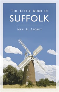
Post mills were once the most common and characteristic of all windmills in Suffolk; indeed most villages and every town would once have had at least one windmill within its bounds. Some fine examples have been preserved such as those at Thorpeness, Holton, Webster’s Mill at Framsden, Saxtead Green Mill at Framlingham and Upthorpe Mill at Stanton, but most have been lost down the years.
In 1937, the Suffolk Preservation Society carried out a survey of post mills in Suffolk that still had significant remaining structure and features, such as intact sails, which was published listing the following. If they are no longer extant and their fate is known it has been added in brackets:
Drinkstone
Earl Soham (Demolished 1947)
Earl Soham, Clowes Corner (Demolished 1947)
Eye (Blown down 1955)
Framlingham, Saxtead Green
Framsden
Friston
Gedding (Demolished 1944)
Halesworth, Calver’s Mill (Demolished 1942)
Hartest (Burned down c. 1958)
Holton St Peter
Laxfield (Demolished c. 1941)
Parham (Demolished 1944)
Peasenhall (Demolished c. 1957)
Petthaugh (Demolished 1957)
South Elmham, St Michael (Demolished c. 1955)
Stanningfield
Stanton, Upthorpe Mill
Stradbroke, Skinner’s Mill (Demolished c. 1941)
Stradbroke, Barley Green (Demolished 1941)
Swilland (Demolished c. 1953)
Syleham (Blown down 1987)
Thornham Magna (Burned down 1959)
Thorpeness
Thurston (Demolished c. 1953)
Wenhaston, Kitty Mill (Demolished c. 1967)
Westhall, Mill Common (Demolished 1957)
Westleton (Demolished 1963)
Wetheringsett, Broad Green Mill (Demolished 1957)
Woolpit (Collapsed 1963)
Worlingworth (Demolished 1952)
Wrentham, Carter’s Mill (Demolished 1955)
SOME OF THE LESSER KNOWN OR MORE UNUSUAL LISTED BUILDINGS AND STRUCTURES
Grade I
The Willis Faber and Dumas Insurance headquarters building in Ipswich, designed by Norman Foster and built 1970–75.
Grade II
The K6 telephone kiosks at Stanningfield, Earl Soham and Orford
The Cowshed Laundry and Dairy Range at Easton Farm Park
The milestone, 10m south of Yoxholme
Denes High School, Yarmouth Road, Lowestoft
Needham Market railway station
Hand Pump and Timber Casing and Warners Almshouses, Boyton
The signpost near St Peter’s Church, Yoxford
The pillar box at the east end of Double Street, Framlingham
The eighteenth-century Gate Pier to the south of Parham House
The Sick House, Grundisburgh Road, Woodbridge
The Elephant & Castle public house, Hospital Road, Bury St Edmunds
The Pillar of Salt road sign on Angel Hill, Bury St Edmunds (designed by Basil Oliver, Town Council architect in 1935)
The garden wall to Regency House Hotel, Looms Lane, Bury St Edmunds
The pump in front of the Mills Almshouses, Framlingham
The water tower, Nacton
Gateway, balustrading and steps over the Ha Ha, near Orwell Park School
The post office, The Street, Walpole
The kitchen store in the garden at Heveningham Hall
TEN PLACE NAMES YOU DON’T EXPECT TO FIND IN SUFFOLK
America Hill (Witnesham)
Gibraltar (near Ashbocking)
California (Wickham Market)
The Trossachs (Oulton Broad)
Klondyke (Bury St Edmunds)
Mendip Road (Lowestoft)
Dublin (near Thorndon)
New England Lane (near Newmarket)
Hyde Park Corner (Ipswich)
Nova Scotia Lane (Brent Eleigh)
Pitcairn Road (Ipswich)
Waterloo Avenue (Leiston)
Edinburgh Gardens (Claydon)
Little London Hill (Stowmarket)
Swiss Farm (Ipswich)
Novocastria (Waldringfield)
Sodom and Gomorrah (Higham)
ECCENTRIC SUFFOLK PLACE NAMES
Nuttery Vale (Cross Street)
Nonsuch Meadows (Sudbury)
The Devil’s Handbasin (Brome)
Flempton
Rat Hill (Harkstead)
Great Tufts (Capel St Mary)
Rattlerow Hill (Stradbroke)
Finger Bread Hill (Trimley St Martin)
The Grindle (Burstall)
Grundisburgh
Hill of Health (Brockley Corner)
Red Sleeve (Capel St Mary)
Amos’s Skirts (Benacre)
Helions Bumpstead
Uggeshall
Pixey Green (Stradbroke)
Dandy Corner (Cotton)
Beggar’s Bush (Gazeley)
Sweffling
Wherstead Ooze
The Spong (Metfield)
Sprites End (Trimley St Mary)
Nedging Tye
Wigwam Hill (Magpie Green)
Brimstone Covert (Frostenden)
Thingoe Hill (Bury St Edmunds)
Burnthouse Queach (Harkstead)
Puddingpokes (Hemley)
AND SOME ECCENTRIC STREET NAMES
Bent Lane (Rushmere
(Rendlesham)
St Andrew)
Grub Lane (Ilketshall St Lawrence)
Swine’s Green (Beccles)
Scuffin’s Lane (Cotton)
Clench Close (Ipswich)
Swilltub Lane (Cotton)
One Eyed Lane (Weybread)
World’s End Lane (Buxhall)
Pesthouse Lane (Barham)
Slushy Lane (Lower Holbrook)
Gobbets Lane (Hinderclay)
Slugs Lane (Somerleyton)
Plash Road (Bedingfield)
Shoe Devil Lane
Great Whip Street (Ipswich)
(Ilketshall St Margaret)
Wacker Field Road
Wriggle Street (Brandeston)
SUFFOLK PLACE NAMES TO MAKE YOU THINK TWICE
Fiddler’s Lane (Eye)
Upend
Wangford
Fingery Grove (Bentley)
Burnt Dick Hill (Boxted)
Screw Park (Redisham)
Westley Bottom
Balls Hill (Hitcham)
Wadd Lane (Gromford)
Piper’s Went (Raydon)
Rogue’s Lane (Wickham Market)
Shaker’s Road (Wangford)
Bloodman’s Corner (Hopton on Sea)
Frizzler’s Green (Great Saxham)
Smear Marshes (Cove Bottom)
Cock’s Head (Hargrave)
Pratt’s Shrubbery (Woolverstone)
Pokerage Corner (Thurston)
Puttock End (Semer)
Cock and End (Stradishall)
Thieves Lane (Grimstone End)
Cock Lane (Hundon)
Deadman’s Lane (Stoke Ash)
Cock Lane (Hundon)
Reydon Smear
Lump Pits Hole (Hoxne)
Earth Holes Wood (Thorington)
NATURAL HISTORY – SPECIAL TO SUFFOLK
The Suffolk Wasp (
Dyscritulus suffolciensis
) was discovered in the county by entomologist Claude Morley (1874–1951).
A population of the rare Scarce Emerald Damselfly (
Lestes dryas
), believed to have become extinct in the 1980s, was discovered at Market Weston Fen in 2007.
The Pied Avocet (Recurvirostra avosetta) became extinct in Britain in 1840 but had a successful re-colonisation at Minsmere in 1947.
The Sizewell Bunting bird, a hybrid between the Pine Bunting and the Yellowhammer, was recorded in the county in 1982.
A black widow (Latrodectus


