
3,10 €
Mehr erfahren.
- Herausgeber: Librorium Editions
- Kategorie: Lebensstil
- Sprache: Englisch
After riding then those ten days from the city of Juju, you find yourself in a kingdom called Taianfu, and the city at which you arrive, which is the capital, is also called Taianfu, a very great and fine city. [But at the end of five days’ journey out of those ten, they say there is a city unusually large and handsome called Acbaluc, whereat terminate in this direction the hunting preserves of the Emperor, within which no one dares to sport except the Emperor and his family, and those who are on the books of the Grand Falconer. Beyond this limit any one is at liberty to sport, if he be a gentleman. The Great Kaan, however, scarcely ever went hunting in this direction, and hence the game, particularly the hares, had increased and multiplied to such an extent that all the crops of the Province were destroyed. The Great Kaan being informed of this, proceeded thither with all his Court, and the game that was taken was past counting.]
Das E-Book können Sie in Legimi-Apps oder einer beliebigen App lesen, die das folgende Format unterstützen:
Veröffentlichungsjahr: 2023
Ähnliche


“Marcvs Polvs Venetvs Totivs Orbis et Indie Peregrator Primus.”
Copied by permission from a painting bearing the above inscription in the Gallery of Monsignore Badia in Rome.
THE TRAVELS OF MARCO POLO
IN TWO VOLUMES
Volume II
© 2023 Librorium Editions
ISBN : 9782383837121
CONTENTS OF VOL. II.
Synopsis of Contents
Explanatory List of Illustrations
The Book of Marco Polo
Appendices
Index
SYNOPSIS OF CONTENTS.
BOOK SECOND—(Continued).
PART II.
Journey to the West and South-West of Cathay.
Chap.
XXXV.
—Here begins the Description of the Interior of Cathay; and first of the River Pulisanghin
Notes.—1. Marco’s Route. 2. The Bridge Pul-i-sangin, or Lu-ku-k’iao.
XXXVI.
—Account of the City of Juju
Notes.—1. The Silks called Sendals. 2. Chochau. 3. Bifurcation of Two Great Roads at this point.
XXXVII.
—The Kingdom of Taianfu
Notes.—1. Acbaluc. 2. T’ai-yuan fu. 3. Grape-wine of that place. 4. P’ing-yang fu.
XXXVIII.
—Concerning the Castle of Caichu. the Golden King and Prester John
Notes.—1. The Story and Portrait of the Roi d’Or. 2. Effeminacy reviving in every Chinese Dynasty.
XXXIX.
—How Prester John treated the Golden King his Prisoner
XL.
—Concerning the Great River Caramoran and the City of Cachanfu
Notes.—1. The Kará Muren. 2. Former growth of silk in Shan-si and Shen-si. 3. The akché or asper.
XLI.
—Concerning the City of Kenjanfu
Notes.—1. Morus alba. 2. Geography of the Route since Chapter XXXVIII. 3. Kenjanfu or Si-ngan fu; the Christian monument there. 4. Prince Mangala.
XLII.
—Concerning the Province of Cuncun, which is right wearisome to travel through
Note.—The Mountain Road to Southern Shen-si.
XLIII.
—Concerning the Province of Acbalec Manzi
Notes.—1. Geography, and doubts about Acbalec. 2. Further Journey into Sze-ch’wan.
XLIV.
—Concerning the Province of Sindafu
Notes.—1. Ch’êng-tu fu. 2. The Great River or Kiang. 3. The word Comercque. 4. The Bridge-Tolls. 5. Correction of Text.
XLV.
—Concerning the Province of Tebet
Notes.—1. The Part of Tibet and events referred to. 2. Noise of burning bamboos. 3. Road retains its desolate character. 4. Persistence of eccentric manners illustrated. 5. Name of the Musk animal.
XLVI.
—Further Discourse concerning Tebet
Notes.—1. Explanatory. 2. “Or de Paliolle.” 3. Cinnamon. 4. 5. Great Dogs, and Beyamini oxen.
XLVII.
—Concerning the Province of Caindu
Notes.—1. Explanation from Ramusio. 2. Pearls of Inland Waters. 3. Lax manners. 4. Exchange of Salt for Gold. 5. Salt currency. 6. Spiced Wine. 7. Plant like the Clove, spoken of by Polo. Tribes of this Tract.
XLVIII.
—Concerning the Province of Carajan
Notes.—1. Geography of the Route between Sindafu or Ch’êng-tu fu, and Carajan or Yun-nan. 2. Christians and Mahomedans in Yun-nan. 3. Wheat. 4. Cowries. 5. Brine-spring. 6. Parallel.
XLIX.
—Concerning a further part of the Province of Carajan
Notes.—1. City of Talifu. 2. Gold. 3. Crocodiles. 4. Yun-nan horses and riders. Arms of the Aboriginal Tribes. 5. Strange superstition and parallels.
L.
—Concerning the Province of Zardandan
Notes.—1. Carajan and Zardandan. 2. The Gold-Teeth. 3. Male Indolence. 4. The Couvade. (See App. L. 8.) 5. Abundance of Gold. Relation of Gold to Silver. 6. Worship of the Ancestor. 7. Unhealthiness of the climate. 8. Tallies. 9.–12. Medicine-men or Devil-dancers; extraordinary identity of practice in various regions.
LI.
—Wherein is related how the King of Mien and Bangala vowed vengeance against the Great Kaan
Notes.—1. Chronology. 2. Mien or Burma. Why the King may have been called King of Bengal also. 3. Numbers alleged to have been carried on elephants.
LII.
—Of the Battle that was fought by the Great Kaan’s Host and his Seneschal against the King of Mien
Notes.—1. Nasruddin. 2. Cyrus’s Camels. 3. Chinese Account of the Action. General Correspondence of the Chinese and Burmese Chronologies.
LIII.
—Of the Great Descent that leads towards the Kingdom of Mien
Notes.—1. Market-days. 2. Geographical difficulties.
LIV.
—Concerning the City of Mien, and the Two Towers that are therein, one of Gold, and the other of Silver
Notes.—1. Amien. 2. Chinese Account of the Invasion of Burma. Comparison with Burmese Annals. The City intended. The Pagodas. 3. Wild Oxen.
LV.
—Concerning the Province of Bangala
Notes.—1. Polo’s view of Bengal; and details of his account illustrated. 2. Great Cattle.
LVI.
—Discourses of the Province of Caugigu
Note.—A Part of Laos. Papesifu. Chinese Geographical Etymologies.
LVII.
—Concerning the Province of Anin
Notes.—1. The Name. Probable identification of territory. 2. Textual.
LVIII.
—Concerning the Province of Coloman
Notes.—1. The Name. The Kolo-man. 2. Natural defences of Kwei-chau.
LIX.
—Concerning the Province of Cuiju
Notes.—1. Kwei-chau. Phungan-lu. 2. Grass-cloth. 3. Tigers. 4. Great Dogs. 5. Silk. 6. Geographical Review of the Route since Chapter LV. 7. Return to Juju.
BOOK SECOND. (Continued.)
PART III.
Journey Southward through Eastern Provinces of Cathay and Manzi.
LX.
—Concerning the Cities of Cacanfu and Changlu
Notes.—1. Pauthier’s Identifications. 2. Changlu. The Burning of the Dead ascribed to the Chinese.
LXI.
—Concerning the City of Chinangli, and that of Tadinfu, and the Rebellion of Litan
Notes.—1. T’si-nan fu. 2. Silk of Shan-tung. 3. Title Sangon. 4. Agul and Mangkutai. 5. History of Litan’s Revolt.
LXII.
—Concerning the Noble City of Sinjumatu
Note.—The City intended. The Great Canal.
LXIII.
—Concerning the Cities of Linju and Piju
Notes.—1. Linju. 2. Piju.
LXIV.
—Concerning the City of Siju, and the Great River Caramoran
Notes.—1. Siju. 2. The Hwang-Ho and its changes. 3. Entrance to Manzi; that name for Southern China.
LXV.
—How the Great Kaan conquered the Province of Manzi
Notes.—1. Meaning and application of the title Faghfur. 2. Chinese self-devotion. 3. Bayan the Great Captain. 4. His lines of Operation. 5. The Juggling Prophecy. 6. The Fall of the Sung Dynasty. 7. Exposure of Infants, and Foundling Hospitals.
LXVI.
—Concerning the City of Coiganju
Note.—Hwai-ngan fu.
LXVII.
—Of the Cities of Paukin and Cayu
Note.—Pao-yng and Kao-yu.
LXVIII.
—Of the Cities of Tiju, Tinju, and Yanju
Notes.—1. Cities between the Canal and the Sea. 2. Yang-chau. 3. Marco Polo’s Employment at this City.
LXIX.
—Concerning the City of Nanghin
Note.—Ngan-king.
LXX.
—Concerning the very Noble City of Saianfu, and how its Capture was effected
Notes.—1. and 2. Various Readings. 3. Digression on the Military Engines of the Middle Ages. 4. Mangonels of Cœur de Lion. 5. Difficulties connected with Polo’s Account of this Siege.
LXXI.
—Concerning the City of Sinju and the Great River Kian
Notes.—1. I-chin hien. 2. The Great Kiang. 3. Vast amount of tonnage on Chinese Waters. 4. Size of River Vessels. 5. Bamboo Tow-lines. 6. Picturesque Island Monasteries.
LXXII.
—Concerning the City of Caiju
Notes.—1. Kwa-chau. 2. The Grand Canal and Rice-Transport. 3. The Golden Island.
LXXIII.
—Of the City of Chinghianfu
Note.—Chin-kiang fu. Mar Sarghis, the Christian Governor.
LXXIV.
—Of the City of Chinginju and the Slaughter of certain Alans there
Notes.—1. Chang-chau. 2. Employment of Alans in the Mongol Service. 3. The Chang-chau Massacre. Mongol Cruelties.
LXXV.
—Of the Noble City of Suju
Notes.—1. Su-chau. 2. Bridges of that part of China. 3. Rhubarb; its mention here seems erroneous. 4. The Cities of Heaven and Earth. Ancient incised Plan of Su-chau. 5. Hu-chau, Wu-kiang, and Kya-hing.
LXXVI.
—Description of the Great City of Kinsay, which is the Capital of the whole Country of Manzi
Notes.—1. King-szé now Hang-chau. 2. The circuit ascribed to the City; the Bridges. 3. Hereditary Trades. 4. The Si-hu or Western Lake. 5. Dressiness of the People. 6. Charitable Establishments. 7. Paved roads. 8. Hot and Cold Baths. 9. Kanp’u, and the Hang-chau Estuary. 10. The Nine Provinces of Manzi. 11. The Kaan’s Garrisons in Manzi. 12. Mourning costume. 13. 14. Tickets recording inmates of houses.
LXXVII.
—[Further Particulars concerning the Great City of Kinsay.]
(From Ramusio only.)
Notes.—1. Remarks on these supplementary details. 2. Tides in the Hang-chau Estuary. 3. Want of a good Survey of Hang-chau. The Squares. 4. Marco ignores pork. 5. Great Pears: Peaches. 6. Textual. 7. Chinese use of Pepper. 8. Chinese claims to a character for Good Faith. 9. Pleasure-parties on the Lake. 10. Chinese Carriages. 11. The Sung Emperor. 12. The Sung Palace. Extracts regarding this Great City from other mediæval writers, European and Asiatic. Martini’s Description.
LXXVIII.
—Treating of the Yearly Revenue that the Great Kaan hath from Kinsay
Notes.—1. Textual. 2. Calculations as to the values spoken of.
LXXIX.
—Of the City of Tanpiju and others
Notes.—1. Route from Hang-chau southward. 2. Bamboos. 3. Identification of places. Chang-shan the key to the route.
LXXX.
—Concerning the Kingdom of Fuju
Notes.—1. “Fruit like Saffron.” 2. 3. Cannibalism ascribed to Mountain Tribes on this route. 4. Kien-ning fu. 5. Galingale. 6. Fleecy Fowls. 7. Details of the Journey in Fo-kien and various readings. 8. Unken. Introduction of Sugar-refining into China.
LXXXI.
—Concerning the Greatness of the City of Fuju
Notes.—1. The name Chonka, applied to Fo-kien here. Cayton or Zayton. 2. Objections that have been made to identity of Fuju and Fu-chau. 3. The Min River.
LXXXII.
—Of the City and Great Haven of Zayton
Notes.—1. The Camphor Laurel. 2. The Port of Zayton or T’swan-chau; Recent objections to this identity. Probable origin of the word Satin. 3. Chinese Consumption of Pepper. 4. Artists in Tattooing. 5. Position of the Porcelain manufacture spoken of. Notions regarding the Great River of China. 6. Fo-kien dialects and variety of spoken language in China. 7. From Ramusio.
BOOK THIRD.
Japan, the Archipelago, Southern India, and the Coasts and Islands of the Indian Sea.
Chap.
I.
—Of the Merchant Ships of Manzi that sail upon the Indian Seas
Notes.—1. Pine Timber. 2. Rudder and Masts. 3. Watertight Compartments. 4. Chinese substitute for Pitch. 5. Oars used by Junks. 6. Descriptions of Chinese Junks from other Mediæval Writers.
II.
—Description of the Island of Chipangu, and the Great Kaan’s Despatch of a Host against it
Notes.—1. Chipangu or Japan. 2. Abundance of Gold. 3. The Golden Palace. 4. Japanese Pearls. Red Pearls.
III.
—What Further came of the Great Kaan’s Expedition against Chipangu
Notes.—1. Kúblái’s attempts against Japan. Japanese Narrative of the Expedition here spoken of. (See App. L. 9.) 2. Species of Torture. 3. Devices to procure Invulnerability.
IV.
—Concerning the Fashion of the Idols
Notes.—1. Many-limbed Idols. 2. The Philippines and Moluccas. 3. The name Chin or China. 4. The Gulf of Cheinan.
V.
—Of the Great Country called Chamba
Notes.—1. Champa, and Kúblái’s dealings with it. (See App. L. 10). 2. Chronology. 3. Eagle-wood and Ebony. Polo’s use of Persian words.
VI.
—Concerning the Great Island of Java
Note.—Java; its supposed vast extent. Kúblái’s expedition against it and failure.
VII.
—Wherein the Isles of Sondur and Condur are spoken of; and the Kingdom of Locac
Notes.—1. Textual. 2. Pulo Condore. 3. The Kingdom of Locac, Southern Siam.
VIII.
—Of the Island called Pentam, and the City Malaiur
Notes.—1. Bintang. 2. The Straits of Singapore. 3. Remarks on the Malay Chronology. Malaiur probably Palembang.
IX.
—Concerning the Island of Java the Less. the Kingdoms of Ferlec and Basma
Notes.—1. The Island of Sumatra: application of the term Java. 2. Products of Sumatra. The six kingdoms. 3. Ferlec or Parlák. The Battas. 4. Basma, Pacem, or Pasei. 5. The Elephant and the Rhinoceros. The Legend of Monoceros and the Virgin. 6. Black Falcon.
X.
—The Kingdoms of Samara and Dagroian
Notes.—1. Samara, Sumatra Proper. 2. The Tramontaine and the Mestre. 3. The Malay Toddy-Palm. 4. Dagroian. 5. Alleged custom of eating dead relatives.
XI.
—Of the Kingdoms of Lambri and Fansur
Notes.—1. Lambri. 2. Hairy and Tailed Men. 3. Fansur and Camphor Fansuri. Sumatran Camphor. 4. The Sago-Palm. 5. Remarks on Polo’s Sumatran Kingdoms.
XII.
—Concerning the Island of Necuveran
Note.—Gauenispola, and the Nicobar Islands.
XIII.
—Concerning the Island of Angamanain
Note.—The Andaman Islands.
XIV.
—Concerning the Island of Seilan
Notes.—1. Chinese Chart. 2. Exaggeration of Dimensions. The Name. 3. Sovereigns then ruling Ceylon. 4. Brazil Wood and Cinnamon. 5. The Great Ruby.
XV.
—The Same Continued. The History of Sagamoni Borcan and the beginning of Idolatry
Notes.—1. Adam’s Peak, and the Foot thereon. 2. The Story of Sakya-Muni Buddha. The History of Saints Barlaam and Josaphat; a Christianised version thereof. 3. High Estimate of Buddha’s Character. 4. Curious Parallel Passages. 5. Pilgrimages to the Peak. 6. The Pâtra of Buddha, and the Tooth-Relic. 7. Miraculous endowments of the Pâtra; it is the Holy Grail of Buddhism.
XVI.
—Concerning the Great Province of Maabar, which is called India the Greater, and is on the Mainland
Notes.—1. Ma’bar, its definition, and notes on its Mediæval History. 2. The Pearl Fishery.
XVII.
—Continues to speak of the Province of Maabar
Notes.—1. Costume. 2. Hindu Royal Necklace. 3. Hindu use of the Rosary. 4. The Saggio. 5. Companions in Death; the word Amok. 6. Accumulated Wealth of Southern India at this time. 7. Horse Importation from the Persian Gulf. 8. Religious Suicides. 9. Suttees. 10. Worship of the Ox. The Govis. 11. Verbal. 12. The Thomacides. 13. Ill-success of Horse-breeding in S. India. 14. Curious Mode of Arrest for Debt. 15. The Rainy Seasons. 16. Omens of the Hindus. 17. Strange treatment of Horses. 18. The Devadásis. 19. Textual.
XVIII.
—Discoursing of the Place where lieth the Body of St. Thomas the Apostle; and of the Miracles thereof
Notes.—1. Mailapúr. 2. The word Avarian. 3. Miraculous Earth. 4. The Traditions of St. Thomas in India. The ancient Church at his Tomb; the ancient Cross preserved on St. Thomas’s Mount. 5. White Devils. 6. The Yak’s Tail.
XIX.
—Concerning the Kingdom of Mutfili
Notes.—1. Motapallé. The Widow Queen of Telingana. 2. The Diamond Mines, and the Legend of the Diamond Gathering. 3. Buckram.
XX.
—Concerning the Province of Lar whence the Brahmans come
Notes.—1. Abraiaman. The Country of Lar. Hindu Character. 2. The Kingdom of Soli or Chola. 3. Lucky and Unlucky Days and Hours. The Canonical Hours of the Church. 4. Omens. 5. Jogis. The Ox-emblem. 6. Verbal. 7. Recurrence of Human Eccentricities.
XXI.
—Concerning the City of Cail
Notes.—1. Káyal; its true position. Kolkhoi identified. 2. The King Ashar or As-char. 3. Correa, Note. 4. Betel-chewing. 5. Duels.
XXII.
—Of the Kingdom of Coilum
Notes.—1. Coilum, Coilon, Kaulam, Columbum, Quilon. Ancient Christian Churches. 2. Brazil Wood: notes on the name. 3. Columbine Ginger and other kinds. 4. Indigo. 5. Black Lions. 6. Marriage Customs.
XXIII.
—Of the Country called Comari
Notes.—1. Cape Comorin. 2. The word Gat-paul.
XXIV.
—Concerning the Kingdom Eli
Notes.—1. Mount D’Ely, and the City of Hili-Máráwi. 2. Textual. 3. Produce. 4. Piratical custom. 5. Wooden Anchors.
XXV.
—Concerning the Kingdom of Melibar
Notes.—1. Dislocation of Polo’s Indian Geography. The name of Malabar. 2. Verbal. 3. Pirates. 4. Cassia: Turbit: Cubebs. 5. Cessation of direct Chinese trade with Malabar.
XXVI.
—Concerning the Kingdom of Gozurat
Notes.—1. Topographical Confusion. 2. Tamarina. 3. Tall Cotton Trees. 4. Embroidered Leather-work.
XXVII.
—Concerning the Kingdom of Tana
Notes.—1. Tana, and the Konkan. 2. Incense of Western India.
XXVIII.
—Concerning the Kingdom of Cambaet
Note.—Cambay.
XXIX.
—Concerning the Kingdom of Semenat
Note.—Somnath, and the so-called Gates of Somnath.
XXX.
—Concerning the Kingdom of Kesmacoran
Notes.—1. Kij-Mekrán. Limit of India. 2. Recapitulation of Polo’s Indian Kingdoms.
XXXI.
—Discourseth of the Two Islands called Male and Female, and why they are so called
Note.—The Legend and its diffusion.
XXXII.
—Concerning the Island of Scotra
Notes.—1. Whales of the Indian Seas. 2. Socotra and its former Christianity. 3. Piracy at Socotra. 4. Sorcerers.
XXXIII.
—Concerning the Island of Madeigascar
Notes.—1. Madagascar; some confusion here with Magadoxo. 2. Sandalwood. 3. Whale-killing. The Capidoglio or Sperm-Whale. 4. The Currents towards the South. 5. The Rukh (and see Appendix L. 11). 6. More on the dimensions assigned thereto. 7. Hippopotamus Teeth.
XXXIV.
—Concerning the Island of Zanghibar. A Word on India in General
Notes.—1. Zangibar; Negroes. 2. Ethiopian Sheep. 3. Giraffes. 4. Ivory trade. 5. Error about Elephant-taming. 6. Number of Islands assigned to the Indian Sea. 7. The Three Indies, and various distributions thereof. Polo’s Indian Geography.
XXXV.
—Treating of the Great Province of Abash, which is Middle India, and is on the Mainland
Notes.—1. Ḥabash or Abyssinia. Application of the name India to it. 2. Fire Baptism ascribed to the Abyssinian Christians. 3. Polo’s idea of the position of Aden. 4. Taming of the African Elephant for War. 5. Marco’s Story of the Abyssinian Invasion of the Mahomedan Low-Country, and Review of Abyssinian Chronology in connection therewith. 6. Textual.
XXXVI.
—Concerning the Province of Aden
Notes.—1. The Trade to Alexandria from India viâ Aden. 2. “Roncins à deux selles.” 3. The Sultan of Aden. The City and its Great Tanks. 4. The Loss of Acre.
XXXVII.
—Concerning the City of Esher
Notes.—1. Shihr. 2. Frankincense. 3. Four-horned Sheep. 4. Cattle fed on Fish. 5. Parallel passage.
XXXVIII.
—Concerning the City of Dufar
Notes.—1. Dhofar. 2. Notes on Frankincense.
XXXIX.
—Concerning the Gulf of Calatu, and the City so called
Notes.—1. Kalhát. 2. “En fra terre.” 3. Maskat.
XL.
—Returns to the City of Hormos whereof we spoke formerly
Notes.—1. Polo’s distances and bearings in these latter chapters. 2. Persian Bád-gírs or wind-catching chimneys. 3. Island of Kish.
BOOK FOURTH.
Wars among the Tartar Princes, and some Account of the Northern Countries.
Chap.
I.
—Concerning Great Turkey
Notes.—1. Kaidu Khan. 2. His frontier towards the Great Kaan.
II.
—Of certain Battles that were fought by King Caidu against the Armies of his Uncle the Great Kaan
Notes.—1. Textual. 2. “Araines.” 3. Chronology in connection with the events described.
III.
—†What the Great Kaan said to the Mischief done by Caidu his nephew
IV.
—Of the Exploits of King Caidu’s valiant Daughter
Note.—Her name explained. Remarks on the story.
V.
—How Abaga sent his Son Argon in command against King Caidu
(Extract and Substance.)
Notes.—1. Government of the Khorasan frontier. 2. The Historical Events.
VI.
—How Argon after the Battle heard that his Father was dead and Went to assume the Sovereignty as was his right
Notes.—1. Death of Ábáká. 2. Textual. 3. Ahmad Tigudar.
VII.
—†How Acomat Soldan set out with his Host against his Nephew who was coming to claim the throne that belonged to him
VIII.
—†How Argon took Counsel with his Followers about attacking his Uncle Acomat Soldan
IX.
—†How the Barons of Argon answered his Address
X.
—†The Message sent by Argon to Acomat
XI.
—How Acomat replied to Argon’s Message
XII.
—Of the Battle between Argon and Acomat, and the Captivity of Argon
Notes.—1. Verbal. 2. Historical.
XIII.
—How Argon was delivered from Prison
XIV.
—How Argon got the Sovereignty at last
XV.
—†How Acomat was taken Prisoner
XVI.
—How Acomat was slain by Order of his Nephew
XVII.
—How Argon was recognised as Sovereign
Notes.—1. The historical circumstances and persons named in these chapters. 2. Arghún’s accession and death.
XVIII.
—How Kiacatu seized the Sovereignty after Argon’s Death
Note.—The reign and character of Kaikhátú.
XIX.
—How Baidu seized the Sovereignty after the Death of Kiacatu
Notes.—1. Baidu’s alleged Christianity. 2. Gházán Khan.
XX.
—Concerning King Conchi who rules the Far North
Notes.—1. Kaunchi Khan. 2. Siberia. 3. Dog-sledges. 4. The animal here styled Erculin. The Vair. 5. Yugria.
XXI.
—Concerning the Land of Darkness
Notes.—1. The Land of Darkness. 2. The Legend of the Mares and their Foals. 3. Dumb Trade with the People of the Darkness.
XXII.
—Description of Rosia and its People. Province of Lac
Notes.—1. Old Accounts of Russia. Russian Silver and Rubles. 2. Lac, or Wallachia. 3. Oroech, Norway (?) or the Waraeg Country (?)
XXIII.
—He begins to speak of the Straits of Constantinople, but decides to leave that matter
XXIV.
—Concerning the Tartars of the Ponent and their Lords
Notes.—1. The Comanians; the Alans; Majar; Zic; the Goths of the Crimea; Gazaria. 2. The Khans of Kipchak or the Golden Horde; errors in Polo’s list. Extent of their Empire.
XXV.
—Of the War that arose between Alau and Barca, and the Battles that they fought
(Extracts and Substance.)
Notes.—1. Verbal. 2. The Sea of Sarai. 3. The War here spoken of. Wassáf’s rigmarole.
XXVI.
—†How Barca and his Army advanced to meet Alau
XXVII.
—†How Alau addressed his followers
XXVIII.
—†Of the Great Battle between Alau and Barca
XXIX.
—How Totamangu was Lord of the Tartars of the Ponent; and after him Toctai
Note.—Confusions in the Text. Historical circumstances connected with the Persons spoken of. Toctai and Noghai Khan. Symbolic Messages.
XXX.
—†Of the Second Message that Toctai sent to Nogai
XXXI.
—†How Toctai marched against Nogai
XXXII.
—†How Toctai and Nogai address their People, and the next Day join Battle
XXXIII.
—†The Valiant Feats and Victory of King Nogai
XXXIV.
—and Last. Conclusion
† Of chapters so marked nothing is given but the substance in brief.
APPENDICES.
A.
Genealogy of the House of Chinghiz to the End of the Thirteenth Century
B.
The Polo Families:—
(I.) Genealogy of the Family of Marco Polo the Traveller
(II.) The Polos of San Geremia
C.
Calendar of Documents relating to Marco Polo and his Family
D.
Comparative Specimens of the Different Recensions of Polo’s Text
E.
Preface to Pipino’s Latin Version
F.
Note of MSS. of Marco Polo’s Book, so far as known:
General Distribution of MSS.
List of Miniatures in two of the finer MSS.
List of MSS. of Marco Polo’s Book, so far as they are known
G.
Diagram showing Filiation of Chief MSS. and Editions of Marco Polo
H.
Bibliography:—
(I.) Principal Editions of Marco Polo’s Book
(II.) Bibliography of Printed Editions
(III.) Titles of Sundry Books and Papers treating of Marco Polo and his Book
I.
Titles of Works quoted by Abbreviated References in this Book
K.
Values of Certain Moneys, Weights, and Measures occurring in this Book
L.
Supplementary Notes to the Book of Marco Polo
The Polos at Acre.
Sorcery in Kashmir.
Paonano Pao.
Pamir.
Number of Pamirs.
Site of Pein.
Fire-arms.
La Couvade.
Alacan.
Champa.
Ruck Quills.
A Spanish Marco Polo.
Sir John Mandeville.
Index
EXPLANATORY LIST OF ILLUSTRATIONS TO VOLUME II.
INSERTED PLATES AND MAPS.
To face page
Title.
Portrait bearing the inscription “Marcus Polvs Venetvs Totivs Orbis et Indie Peregrator Primvs.” In the Gallery of Monsignor Badia at Rome; copied by Sign. Giuseppe Gnoli, Rome.
xxiv.
Medallion, representing Marco Polo in the Prison of Genoa, dictating his story to Master Rustician of Pisa, drawn by Signor Quinto Cenni from a rough design by Sir Henry Yule.
29.
The celebrated Christian Inscription of Si-ngan fu. Photolithographed by Mr. W. Grigg, from a Rubbing of the original monument, given to the Editor by the Baron F. von Richthofen.
This rubbing is more complete than that used in the first edition, for which the Editor was indebted to the kindness of William Lockhart, Esq.
79.
The Lake of Tali (Carajan of Polo) from the Northern End. Woodcut after Lieut. Delaporte, borrowed from Lieut. Garnier’s Narrative in the Tour du Monde.
79.
Suspension Bridge, neighbourhood of Tali. From a photograph by M. Tannant.
111.
The City of Mien, with the Gold and Silver Towers. From a drawing by the Editor, based upon his sketches of the remains of the City so called by Marco Polo, viz., Pagán, the mediæval capital of Burma.
131.
Itineraries of Marco Polo. No. V. The Indo-Chinese Countries. With a small sketch extracted from a Chinese Map in the possession of Baron von Richthofen, showing the position of Kien-ch’ang, the Caindu of Marco Polo.
143.
Sketch Map exhibiting the Variations of the Two Great Rivers of China, within the Period of History.
182.
The City of Su-chau. Reduced by the Editor from a Rubbing of a Plan incised on Marble, and preserved in the Great Confucian Temple in the City.
The date of the original set of Maps, of which this was one, is uncertain, owing to the partial illegibility of the Inscription; but it is subsequent to A.D. 1000. They were engraved on the Marble A.D. 1247. Many of the names have been obliterated, and a few of those given in the copy are filled up from modern information, as the Editor learns from Mr. Wylie, to whom he owes this valuable illustration.
193.
Map of Hang-chau fu and its Lake, from Chinese Sources.
The Map as published in the former edition was based on a Chinese Map in the possession of Dr. W. Lockhart, with some particulars from Maps in a copy of the Local Topography, Hang-Chau-fu-chi, in the B. Museum Library. In the second edition the Map has been entirely redrawn by the Editor, with many corrections, and with the aid of new materials, supplied by the kindness of the Rev. G. Moule of the Church Mission at Hang-chau. These materials embrace a Paper read by Mr. Moule before the N. China Branch of the R. As. Soc. at Shang-hai; a modern engraved Map of the City on a large scale; and a large MS. Map of the City and Lake, compiled by John Shing, Tailor, a Chinese Christian and Catechist;
The small Side-plan is the City of Si-ngan fu, from a plan published during the Mongol rule, in the 14th century, a tracing of which was sent by Mr. Wylie. The following references could not be introduced in lettering for want of space:—
Yuen-Tu-Kwan (Tauist Monastery).
Chapel of Hien-ning Prince.
Leih-Ching Square (
Fang
).
Tauist Monastery.
Kie-lin General Court.
Ancestral Chapel of Yang-Wan-Kang.
Chapel of the Mid-year Genius.
Temple of the Martial Peaceful King.
Stone where officers are selected.
Mews.
Jasper-Waves Square (
Fang
).
Court of Enquiry.
Gate of the Făng-Yuen Circuit.
Bright Gate.
Northern Tribunal.
Refectory.
Chapel of the Făng-Yuen Prince.
Embroidery manufactory.
Hwa-li Temple.
Old Superintendency of Investigations.
Superintendent of Works.
Ka-yuen Monastery.
Prefectural Confucian Temple.
Benevolent Institution.
Temple of Tu-Ke-King.
Balustrade enclosure.
Medicine-Bazar Street.
Tsin and Ching States Chapel.
Square of the Double Cassia Tree.
N.B.—The shaded spaces are marked in the original Min-Keu “Dwellings of the People.”
213.
Plan of Southern Part of the City of King-szé (or Hang-chau), with the Palace of the Sung Emperors. From a Chinese Plan forming part of a Reprint of the official Topography of the City during the period Hien-Shun (1265–1274) of the Sung Dynasty, i.e. the period terminated by the Mongol conquest of the City and Empire. Mr. Moule, who possesses the Chinese plan (with others of the same set), has come to the conclusion that it is a copy at second-hand. Names that are underlined are such as are preserved in the modern Map of Hang-chau. I am indebted for the use of the original plan to Mr. Moule; for the photographic copy and rendering of the names to Mr. Wylie.
241.
Sketch Map of the Great Ports of Fo-kien, to illustrate the identity of Marco Polo’s Zayton. Besides the Admiralty Charts and other well-known sources the Editor has used in forming this a “Missionary Map of Amoy and the Neighbouring Country,” on a large scale, sent him by the Rev. Carstairs Douglas, LL.D., of Amoy. This contains some points not to be found in the others.
246.
Itineraries of Marco Polo, No. VI. The Journey through Kiang-Nan, Che-kiang, and Fo-kien.
313.
1. Map to illustrate Marco Polo’s Chapters on the Malay Countries. 2. Map to illustrate his Chapters on Southern India.
375.
1. Sketch showing the Position of Káyal in Tinnevelly. 2. Map showing the Position of the Kingdom of Ely in Malabar.
440.
Aden, with the attempted Escalade under Alboquerque in 1513, being the Reduced Facsimile of a large contemporary Wood Engraving in the Map Department of the British Museum. (Size of the original 42½ inches by 19⅛ inches.) Photolithographic Reduction by Mr. G. B. Praetorius, through the assistance of R. H. Major, Esq.
474.
Facsimile of the Letters sent to Philip the Fair, King of France, by Arghún Khan, in A.D. 1289, and by Oljaïtu, in A.D. 1305, preserved in the Archives of France, and reproduced from the Recueil des Documents de l’Époque Mongole by kind permission of H.H. Prince Roland Bonaparte.
594.
Some of the objects found by Dr. M. A. Stein, in Central Asia. From a photograph kindly lent by the Traveller.
WOODCUTS PRINTED WITH THE TEXT.
Book Second.—Part Second.
Page
4.
The Bridge of Pulisanghin, the Lu-ku-k’iao of the Chinese, reduced from a large Chinese Engraving in the Geographical work called Ki-fu-thung-chi in the Paris Library. I owe the indication of this, and of the Portrait of Kúblái Kaan in vol. i. to notes in M. Pauthier’s edition.
5.
The Bridge of Pulisanghin. From the Livre des Merveilles.
8.
Bridge of Lu-ku-k’iao. From a photograph by Count de Semallé.
9.
Bridge of Lu-ku-k’iao. From a photograph by Count de Semallé.
19.
The Roi d’Or. Professed Portrait of the Last of the Altun Khans or Kin Emperors of Cathay, from the (fragmentary) Arabic Manuscript of Rashiduddin’s History in the Library of the Royal Asiatic Society. This Manuscript is supposed to have been transcribed under the eye of Rashiduddin, and the drawings were probably derived from Chinese originals.
26.
Plan of Ki-chau, after Duhalde.
30.
The Cross incised at the head of the Great Christian Inscription of Si-ngan fu (A.D. 781); actual size, from copy of a pencil rubbing made on the original by the Rev. J. Lees. Received from Mr. A. Wylie.
38.
Diagram to elucidate the cities of Ch’êng-tu fu.
39.
Plan of Ch’êng-tu. From Marcel Monnier’sTour d’Asie, by kind permission of M. Plon.
41.
Bridge near Kwan-hsien (Ch’êng-tu). From Marcel Monnier’sTour d’Asie, by kind permission of M. Plon.
47.
Mountaineers on the Borders of Sze-ch’wan and Tibet, from one of the illustrations to Lieut. Garnier’s Narrative (see p. 48). From Tour du Monde.
50.
Village of Eastern Tibet on Sze-ch’wan Frontier. From Mr. Cooper’s Travels of a Pioneer of Commerce.
52.
Example of Roads on the Tibetan Frontier of China (being actually a view of the Gorge of the Lan t’sang Kiang). From Mr. Cooper’s Travels of a Pioneer of Commerce.
55.
The Valley of the Kin-sha Kiang, near the lower end of the Caindu of Marco Polo. From Lieut. Garnier in the Tour du Monde.
58.
Salt Pans in Yun-nan. From the same.
61.
Black Lolo.
62.
White Lolo. From Devéria’sFrontière Sino-annamite.
66.
Pa-y Script. From the T’oung-Pao.
68.
Garden-House on the Lake of Yun-nan-fu, Yachi of Polo. From Lieut. Garnier in the Tour du Monde.
72.
Road descending from the Table-Land of Yun-nan into the Valley of the Kin-sha Kiang (the Brius of Polo). From the same.
73.
“A Saracen of Carajan,” being the portrait of a Mahomedan Mullah in Western Yun-nan. From the same.
75.
The Canal at Yun-nan fu. From a photograph by M. Tannant.
78.
“Riding long like Frenchmen,” exemplified from the Bayeux Tapestry. After Lacroix, Vie Militaire du Moyen Age.
83.
The Sang-miau tribe of Kwei-chau, with the Cross-bow. From a coloured drawing in a Chinese work on the Aboriginal Tribes, belonging to W. Lockhart, Esq.
90.
Portraits of a Kakhyen man and woman. Drawn by Q. Cenni from a photograph (anonymous).
108.
Temple called Gaudapalén in the city of Mien (i.e. Pagán in Burma), erected circaA.D. 1160. Engraving after a sketch by the first Editor, from Fergusson’s History of Architecture.
111.
The Palace of the King of Mien in modern times (viz., the Palace at Amarapura). From the same, being partly from a sketch by the first Editor.
118.
Script Pa-pe. From the T’oung-Pao.
122.
Ho-nhi and other Tribes in the Department of Lin-ngan in S. Yun-nan, supposed to be the Anin country of Marco Polo. From Garnier in the Tour du Monde.
125.
The Koloman tribe, on borders of Kwei-chau and Yun-nan. From coloured drawing in Mr. Lockhart’s book as above (under p. 83).
129.
Script thaï of Xieng-hung. From the T’oung-Pao.
130.
Iron Suspension Bridge at Lowatong. From Garnier in Tour du Monde.
131.
Fortified Villages on Western Frontier of Kwei-chau.From the same.
Book Second.—Part Third.
Page
155.
Yang-chau: the three Cities under the Sung.
156.
Yang-chau: the Great City under the Sung. From Chinese Plans kindly sent to the present Editor by the late Father H. Havret, S.J., Zi-ka-wei.
162.
Mediæval Artillery Engines. Figs, 1, 2, 3, 4, and 5, are Chinese. The first four are from the Encyclopædia San-Thsai-Thou-hoei (Paris Library), the last from Amyot, vol. viii.
Figs. 6, 7, 8 are Saracen, 6 and 7 are taken from the work of Reinaud and Favé, Du Feu Grégeois, and by them from the Arabic MS. of Hassan al Raumah (Arab Anc. Fonds, No. 1127). Fig. 8 is from Lord Munster’s Arabic Catalogue of Military Works, and by him from a MS. of Rashiduddin’s History.
The remainder are European. Fig. 9 is from Pertz, Scriptores, vol. xviii., and by him from a figure of the Siege of Arbicella, 1227, in a MS. of Genoese Annals (No. 773, Supp. Lat. of Bib. Imp.). Fig. 10 from Shaw’s Dresses and Decorations of the Middle Ages, vol. i., No. 21, after B. Mus. MS. Reg. 16, G. vi. Fig. 11 from Pertz as above, under A.D. 1182. Fig. 12, from Valturius de Re Militari, Verona, 1483. Figs. 13 and 14 from the Poliorceticon of Justus Lipsius. Fig. 15 is after the Bodleian MS. of the Romance of Alexander (A.D. 1338), but is taken from the Gentleman’s Magazine, 3rd ser. vol. vii. p. 467. Fig. 16 from Lacroix’s Art au Moyen Age, after a miniature of 13th cent. in the Paris Library. Figs. 17 and 18 from the Emperor Napoleon’s Études de l’Artillerie, and by him taken from the MS. of Paulus Santinus (Lat. MS. 7329 in Paris Library). Fig. 19 from Professor Moseley’s restoration of a Trebuchet, after the data in the Mediæval Note-book of Villars de Honcourt, in Gentleman’s Magazine as above. Figs. 20 and 21 from the Emperor’s Book. Fig. 22 from a German MS. in the Bern Library, the Chronicle of Justinger and Schilling.
169.
Coin from a treasure hidden during the siege of Siang-yang in 1268–73, and lately discovered in that city.
172.
Island Monasteries on the Yang-tzŭ kiang; viz.:—
1. Uppermost. The “Little Orphan Rock,” after a cut in Oliphant’s Narrative.
2. Middle. The “Golden Island” near Chin-kiang fu, after Fisher’s China. (This has been accidentally reversed in the drawing.)
3. Lower. The “Silver Island,” below the last, after Mr. Lindley’s book on the T’ai-P’ings.
177.
The West Gate of Chin-kiang fu. From an engraving in Fisher’s China after a sketch made by Admiral Stoddart, R.N., in 1842.
183.
South-West Gate and Water Gate of Su-chau; facsimile on half scale from the incised Map of 1247. (See List of Inserted Plates preceding, under p. 182.)
193.
The old Luh-ho-ta or Pagoda of Six Harmonies near Hang-chau, and anciently marking the extreme S.W. angle of the city. Drawn by Q. Cenni from an anonymous photograph received from the Rev. G. Moule.
196.
Imperial City of Hang-chau in the 13th Century.
197.
Metropolitan City of Hang-chau in the 13th Century. From the Notes of the Right Rev. G. E. Moule.
209.
Fang of Si-ngan Fu. Communicated by A. Wylie.
212.
Stone Chwang or Umbrella Column, one of two which still mark the site of the ancient Buddhist Monastery called Fan-T’ien-Sze or “Brahma’s Temple” at Hang-chau. Reduced from a pen-and-ink sketch by Mr. Moule.
223.
Mr. Phillips’ Theory of Marco Polo’s Route through Fo-Kien.
228.
Scene in the Bohea Mountains, on Polo’s route between Kiang-Si and Fo-Kien. From Fortune’s Three Years’ Wanderings.
233.
Scene on the Min River below Fu-chau. From the same.
245.
The Kaan’s Fleet leaving the Port of Zayton. The scenery is taken from an engraving in Fisher’s China, purporting to represent the mouth of the Chinchew River (or River of Tswan-chau), after a sketch by Capt. (now Adm.) Stoddart. But the Rev. Dr. Douglas, having pointed out that this cut really supported his view of the identity of Zayton, being a view of the Chang-chau River, reference was made to Admiral Stoddart, and Dr. Douglas proves to be quite right. The View was really one of the Chang-chau River; but the Editor has not been able to procure material for one of the Tswan-chau River, and so he leaves it.
Book Third
Page
248.
The Kaan’s Fleet passing through the Indian Archipelago. From a drawing by the Editor.
254.
Ancient Japanese Emperor, after a Native Drawing. From the Tour du Monde.
257.
Ancient Japanese Archer, after a native drawing. From the same.
261.
The Japanese engaged in combat with the Chinese, after an ancient native drawing. From Charton, Voyageurs Anciens et Modernes.
273.
Java. A view in the interior. From a sketch of the slopes of the Gedéh Volcano, taken by the Editor in 1860.
274.
Bas Relief of one of the Vessels frequenting the Ports of Java in the Middle Ages. From one of the sculptures of the Boro Bodor, after a photograph.
289.
The three Asiatic Rhinoceroses. Adapted from a proof of a woodcut given to the Editor for the purpose by the late eminent zoologist, Edward Blyth. It is not known to the Editor whether the cut appeared in any other publication.
291.
Monoceros and the Maiden. From a mediæval drawing engraved in Cahier et Martin, Mélanges d’Archéologie, II. Pl. 30.
310.
The Borús. From a manuscript belonging to the late Charles Schefer, now in the Bibliothèque Nationale, Paris.
311.
The Cynocephali. From the Livre des Merveilles.
321.
Adam’s Peak from the Sea.
327.
Sakya Muni as a Saint of the Roman Martyrology. Facsimile from an old German version of the story of Barlaam and Josaphat (circa 1477), printed by Zainer at Augsburg, in the British Museum.
330.
Tooth Reliques of Buddha. 1. At Kandy, after Emerson Tennent. 2. At Fu-chau, after Fortune.
336.
“Chinese Pagoda” (so called) at Negapatam. From a sketch taken by Sir Walter Elliot, K.C.S.I., in 1846.
352.
Pagoda at Tanjore. From Fergusson’s History of Architecture.
353.
Ancient Cross with Pehlvi Inscription, preserved in the church on St. Thomas’s Mount near Madras. From a photograph, the gift of A. Burnell, Esq., of the Madras Civil Service, assisted by a lithographic drawing in his unpublished pamphlet on Pehlvi Crosses in South India. N.B.—The lithograph has now appeared in the Indian Antiquary, November, 1874.
356.
The Little Mount of St. Thomas, near Madras. After Daniel.
358.
Small Map of the St. Thomas localities at Madras.
378.
Ancient Christian Church at Parúr or Palúr, on the Malabar Coast; from an engraving in Pearson’s Life of Claudius Buchanan, after a sketch by the latter.
379.
Syrian Church at Caranyachirra, showing the quasi-Jesuit Façade generally adopted in modern times. From the Life of Bishop Daniel Wilson.
379.
Interior of Syrian Church at Kötteiyam. From the same.
384.
Cape Comorin. From an original sketch by Mr. Foote of the Geological Survey of India.
387.
Mount d’Ely. From a nautical sketch of last century.
393.
Mediæval Architecture in Guzerat, being a view of Gateway at Jinjawára, given in Forbes’s Ras Mala. From Fergusson’s History of Architecture.
399.
The Gates of Somnath (so called), as preserved in the British Arsenal at Agra. From a photograph by Messrs. Shepherd and Bourne, converted into an elevation.
415.
The Rukh, after a Persian drawing. From Lane’s Arabian Nights.
416.
Frontispiece of A. Müller’s Marco Polo, showing the Bird Rukh.
425.
The Ethiopian Sheep. From a sketch by Miss Catherine Frere.
441.
View of Aden in 1840. From a sketch by Dr. R. Kirk in the Map-room of the Royal Geographical Society.
447.
The Harvest of Frankincense in Arabia. Facsimile of an engraving in Thevet’s Cosmographie Universelle (1575). Reproduced from Cassell’s Bible Educator, by the courtesy of the publishers.
448.
Boswellia Frereana, from a drawing by Mr. W. H. Fitch. The use of this engraving is granted by the India Museum through the kindness of Sir George Birdwood.
453.
A Persian Bád-gír, or Wind-Catcher. From a drawing in the Atlas to Hommaire de Hell’s Persia. Engraved by Adeney.
Book Fourth.
Page
478.
Tomb of Oljaitu Khan, the brother of Polo’s Casan, at Sultaniah. From Fergusson’s History of Architecture.
483.
The Siberian Dog-Sledge. From the Tour du Monde.
489.
Mediæval Russian Church. From Fergusson’s History of Architecture.
493.
Figure of a Tartar under the Feet of Henry Duke of Silesia, Cracow, and Poland, from the tomb at Breslau of that Prince, killed in battle with the Tartar host, 9th April, 1241. After a plate in Schlesische Fürstenbilder des Mittelalters, Breslau, 1868.
501.
Asiatic Warriors of Polo’s Age. From the MS. of Rashiduddin’s History, noticed under cut at p. 19. Engraved by Adeney.
Appendices.
Page
555.
Figure of Marco Polo, from the first printed edition of his Book, published in German at Nuremberg 1477. Traced from a copy in the Berlin Library. (This tracing was the gift of Mr. Samuel D. Horton, of Cincinnati, through Mr. Marsh.)
595.
Marco Polo’s rectified Itinerary from Khotan to Nia.
Marco Polo in the Prison of Genoa.
THEBOOK OF MARCO POLO
BOOK II.—CONTINUED.
Part II.—JOURNEY TO THE WEST AND SOUTH-WEST OF CATHAY.
CHAPTER XXXV.
Here begins the Description of the Interior of Cathay, and first of the River Pulisanghin.
Now you must know that the Emperor sent the aforesaid Messer Marco Polo, who is the author of this whole story, on business of his into the Western Provinces. On that occasion he travelled from Cambaluc a good four months’ journey towards the west.{1} And so now I will tell you all that he saw on his travels as he went and returned.
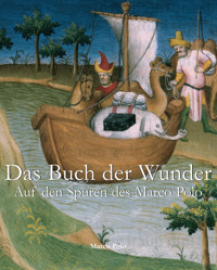
When you leave the City of Cambaluc and have ridden ten miles, you come to a very large river which is called Pulisanghin, and flows into the ocean, so that merchants with their merchandise ascend it from the sea. Over this River there is a very fine stone bridge, so fine indeed, that it has very few equals. The fashion of it is this: it is 300 paces in length, and it must have a good eight paces of width, for ten mounted men can ride across it abreast. It has 24 arches and as many water-mills, and ’tis all of very fine marble, well built and firmly founded. Along the top of the bridge there is on either side a parapet of marble slabs and columns, made in this way. At the beginning of the bridge there is a marble column, and under it a marble lion, so that the column stands upon the lion’s loins, whilst on the top of the column there is a second marble lion, both being of great size and beautifully executed sculpture. At the distance of a pace from this column there is another precisely the same, also with its two lions, and the space between them is closed with slabs of grey marble to prevent people from falling over into the water. And thus the columns run from space to space along either side of the bridge, so that altogether it is a beautiful object.{2}
The Bridge of Pulisanghin. (Reduced from a Chinese original.)
“—et desus cest flum a un mout biaus pont de pieres: car sachiez qe pont n’a en tout le monde de si biaus ne son pareil.”
Note 2.—Pul-i-Sangín, the name which Marco gives the River, means in Persian simply (as Marsden noticed) “The Stone Bridge.” In a very different region the same name often occurs in the history of Timur applied to a certain bridge, in the country north of Badakhshan, over the Wakhsh branch of the Oxus. And the Turkish admiral Sidi ’Ali, travelling that way from India in the 16th century, applies the name, as it is applied here, to the river; for his journal tells us that beyond Kuláb he crossed “the River Pulisangin.”
A Housselin d.
The Bridge of Pulisanghin. (From the Livre des Merveilles.)
We may easily suppose, therefore, that near Cambaluc also, the Bridge, first, and then the River, came to be known to the Persian-speaking foreigners of the court and city by this name. This supposition is however a little perplexed by the circumstance that Rashiduddin calls the River the Sangín, and that Sangkan-Ho appears from the maps or citations of Martini, Klaproth, Neumann, and Pauthier to have been one of the Chinese names of the river, and indeed, Sankang is still the name of one of the confluents forming the Hwan Ho.
[“By Sanghin, Polo renders the Chinese Sang-kan, by which name the River Hun-ho is already mentioned, in the 6th century of our era. Hun-ho is also an ancient name; and the same river in ancient books is often called Lu-Kou River also. All these names are in use up to the present time; but on modern Chinese maps, only the upper part of the river is termed Sang-Kan ho, whilst south of the inner Great Wall, and in the plain, the name of Hun-ho is applied to it. Hun ho means “Muddy River,” and the term is quite suitable. In the last century, the Emperor K’ien-lung ordered the Hun-ho to be named Yung-ting ho, a name found on modern maps, but the people always call it Hun ho.” (Bretschneider, Peking, p. 54.)—H. C.]
The River is that which appears in the maps as the Hwan Ho, Hun-ho, or Yongting Ho, flowing about 7 miles west of Peking towards the south-east and joining the Pe-Ho at Tientsin; and the Bridge is that which has been known for ages as the Lu-kou-K’iao or Bridge of Lukou, adjoining the town which is called in the Russian map of Peking Feuchen, but in the official Chinese Atlas Kung-Keih-cheng. (See Map at ch. xi. of Bk. II. in the first Volume.) [“Before arriving at the bridge the small walled city of Kung-ki cheng is passed. This was founded in the first half of the 17th century. The people generally call it Fei-ch’eng.” (Bretschneider, Peking, p. 50.)—H. C.] It is described both by Magaillans and Lecomte, with some curious discrepancies, whilst each affords particulars corroborative of Polo’s account of the character of the bridge. The former calls it the finest bridge in China. Lecomte’s account says the bridge was the finest he had yet seen. “It is above 170 geometrical paces (850 feet) in length. The arches are small, but the rails or side-walls are made of a hard whitish stone resembling marble. These stones are more than 5 feet long, 3 feet high, and 7 or 8 inches thick; supported at each end by pilasters adorned with mouldings and bearing the figures of lions.... The bridge is paved with great flat stones, so well joined that it is even as a floor.”
Magaillans thinks Polo’s memory partially misled him, and that his description applies more correctly to another bridge on the same road, but some distance further west, over the Lieu-li Ho. For the bridge over the Hwan Ho had really but thirteen arches, whereas that on the Lieu-li had, as Polo specifies, twenty-four. The engraving which we give of the Lu-kou K’iao from a Chinese work confirms this statement, for it shows but thirteen arches. And what Polo says of the navigation of the river is almost conclusive proof that Magaillans is right, and that our traveller’s memory confounded the two bridges. For the navigation of the Hwan Ho, even when its channel is full, is said to be impracticable on account of rapids, whilst the Lieu-li Ho, or “Glass River,” is, as its name implies, smooth, and navigable, and it is largely navigated by boats from the coal-mines of Fang-shan. The road crosses the latter about two leagues from Cho-chau. (See next chapter.)
[The Rev. W. S. Ament (M. Polo in Cambaluc, p. 116–117) remarks regarding Yule’s quotation from Magaillans that “a glance at Chinese history would have explained to these gentlemen that there was no stone bridge over the Liu Li river till the days of Kia Tsing, the Ming Emperor, 1522 A.D., or more than one hundred and fifty years after Polo was dead. Hence he could not have confounded bridges, one of which he never saw. The Lu Kou Bridge was first constructed of stone by She Tsung, fourth Emperor of the Kin, in the period Ta Ting 1189 A.D., and was finished by Chang Tsung 1194 A.D. Before that time it had been constructed of wood, and had been sometimes a stationary and often a floating bridge. The oldest account [end of 16th century] states that the bridge was pu 200 in length, and specifically states that each pu was 5 feet, thus making the bridge 1000 feet long. It was called the Kuan Li Bridge. The Emperor, Kia Tsing of the Ming, was a great bridge builder. He reconstructed this bridge, adding strong embankments to prevent injury by floods. He also built the fine bridge over the Liu Li Ho, the Cho Chou Bridge over the Chü Ma Ho. What cannot be explained is Polo’s statement that the bridge had twenty-four arches, when the oldest accounts give no more than thirteen, there being eleven at the present time. The columns which supported the balustrade in Polo’s time rested upon the loins of sculptured lions. The account of the lions after the bridge was repaired by Kia Tsing says that there are so many that it is impossible to count them correctly, and gossip about the bridge says that several persons have lost their minds in making the attempt. The little walled city on the east end of the bridge, rightly called Kung Chi, popularly called Fei Ch’eng, is a monument to Ts’ung Chêng, the last of the Ming, who built it, hoping to check the advance of Li Tzu ch’eng, the great robber chief who finally proved too strong for him.”—H. C.]
Bridge of Lu-ku k’iao.
The Bridge of Lu-kou is mentioned more than once in the history of the conquest of North China by Chinghiz. It was the scene of a notable mutiny of the troops of the Kin Dynasty in 1215, which induced Chinghiz to break a treaty just concluded, and led to his capture of Peking.
This bridge was begun, according to Klaproth, in 1189, and was five years a-building. On the 17th August, 1688, as Magaillans tells us, a great flood carried away two arches of the bridge, and the remainder soon fell. [Father Intorcetta, quoted by Bretschneider (Peking, p. 53), gives the 25th of July, 1668, as the date of the destruction of the bridge, which agrees well with the Chinese accounts.—H. C.] The bridge was renewed, but with only nine arches instead of thirteen, as appears from the following note of personal observation with which Dr. Lockhart has favoured me:
“At 27 li from Peking, by the western road leaving the gate of the Chinese city called Kwang-’an-măn, after passing the old walled town of Feuchen, you reach the bridge of Lo-Ku-Kiao. As it now stands it is a very long bridge of nine arches (real arches) spanning the valley of the Hwan Ho, and surrounded by beautiful scenery. The bridge is built of green sandstone, and has a good balustrade with short square pilasters crowned by small lions. It is in very good repair, and has a ceaseless traffic, being on the road to the coal-mines which supply the city. There is a pavilion at each end of the bridge with inscriptions, the one recording that K’ang-hi (1662–1723) built the bridge, and the other that Kienlung (1736–1796) repaired it.” These circumstances are strictly consistent with Magaillans’ account of the destruction of the mediæval bridge. Williamson describes the present bridge as about 700 feet long, and 12 feet wide in the middle part.
[Dr. Bretschneider saw the bridge, and gives the following description of it: “The bridge is 350 ordinary paces long and 18 broad. It is built of sandstone, and has on either side a stone balustrade of square columns, about 4 feet high, 140 on each side, each crowned by a sculptured lion over a foot high. Beside these there are a number of smaller lions placed irregularly on the necks, behind the legs, under the feet, or on the back of the larger ones. The space between the columns is closed by stone slabs. Four sculptured stone elephants lean with their foreheads against the edge of the balustrades. The bridge is supported by eleven arches. At each end of the bridge two pavilions with yellow roofs have been built, all with large marble tablets in them; two with inscriptions made by order of the Emperor K’ang-hi (1662–1723); and two with inscriptions of the time of K’ien-lung (1736–1796). On these tablets the history of the bridge is recorded.” Dr. Bretschneider adds that Dr. Lockhart is also right in counting nine arches, for he counts only the waterways, not the arches resting upon the banks of the river. Dr. Forke (p. 5) counts 11 arches and 280 stone lions.—H. C.]
(P. de la Croix, II. 11, etc.; Erskine’s Baber, p. xxxiii.; Timour’s Institutes, 70; J. As. IX. 205; Cathay, 260; Magaillans, 14–18, 35; Lecomte in Astley, III. 529; J. As. sér. II. tom. i. 97–98; D’Ohsson, I. 144.)
Bridge of Lu-ku k’iao.
CHAPTER XXXVI.
Account of the City of Juju.
When


