Erhalten Sie Zugang zu diesem und mehr als 300000 Büchern ab EUR 5,99 monatlich.
- Herausgeber: The History Press
- Kategorie: Lebensstil
- Sprache: Englisch
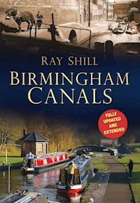
Birmingham is famously reputed to have more miles of canals than Venice. These canals contributed much to the city's growth, bringing coal and merchandise from the surrounding areas. As the city prospered economically, it continued to grow and absorb neighbouring communities, a process in many ways bound together by the waterways. Although part of the national network, Birmingham's canals, including the Worcester & Birmingham, the Stratford-upon-Avon and the Birmingham Canal Navigation, retain their original identity – and most are still in water and used regularly, albeit in different ways to their original industrial purpose. Fully updated and illustrated with stunning new photographs, this book captures the heritage, development and modern role of Birmingham's canals in a way that will appeal to canal users as well as those with a wider interest in Britain's second most populous city.
Sie lesen das E-Book in den Legimi-Apps auf:
Seitenzahl: 126
Veröffentlichungsjahr: 2013
Das E-Book (TTS) können Sie hören im Abo „Legimi Premium” in Legimi-Apps auf:
Ähnliche


Contents
Title Page
Prologue to the Second Edition
Acknowledgements
Introduction
1 The Birmingham Canal Navigations
2 Worcester & Birmingham Canal
3 Stratford Upon Avon Canal
4 Dudley Canal
5 Grand Union Canal
6 Canal & River Trust
Copyright
Prologue to the Second Edition
The reprint was first suggested for 2011, but the final checks for Silent Highways and the subsequent promotion of that work, which deals with the construction of navigable waterways in the West and East Midlands, delayed the editing and updating of this second edition. The author has brought in new modern images, as well as additional archive images, to improve on the original text and update the work to include the changes of the last twelve years. Captions have been updated where necessary and historical data added through the result of new research. One image has required re-captioning as a result of correspondence and feedback following the publication of the first edition.
The sad loss of industrial heritage has continued, but in its place often sympathetic new development has enhanced the canal side and increased the popularity of the waterways as a boater’s destination.
Acknowledgements
The original edition thanked various people and organisations for their help in providing information or images. While several contributors are now deceased, it remains important to recognise their contribution. Those acknowledged were as follows:
Aerofilms
Jeff Bennett, former boatman with Caggy Stevens
Birmingham Canal Navigations Society
Birmingham Public Libraries, Archives Department
Birmingham Public Libraries, Local Studies Department
Hugh Compton, Railway, Canal & Historical Society
Mike Constable
Steve Crook
George Dale
Alan Faulkner
Gloucester Waterways Museum
Roy Jamieson
Martin O’Keeffe
John Miller
National Waterways Museum, Ellesmere Port
Colin Scrivenor
Sandwell Public Libraries
John Whybrow
Worcester & Birmingham Canal Society
Canals of Birmingham. Birmingham grew from a small town to a great city within a period of 100 years. As Birmingham grew in size, more canals were encompassed within its boundaries.
Introduction
It is said that there are more miles of canals in Birmingham than in Venice. If all the canals within the City of Birmingham are taken into account, then this is probably a statement close to the truth. But if the old town of Birmingham is considered, the mileage is much less.
The canals contributed much to the growth of Birmingham through bringing coal and merchandise into the town. Birmingham was a small Warwickshire town which extended from Deritend, beside the River Rea, to the wild heath at Soho. From 1838 until 1931 Birmingham continued to grow in size, absorbing neighbouring communities. The greatest expansion happened in 1911 when Handsworth (Staffordshire), Aston Manor and Erdington (Warwickshire) and Kings Norton, Northfield and Yardley (Worcestershire) became part of the City of Birmingham.
Canal mileage from three counties was added to that which passed through the old town. Originally independent, canal companies were responsible for the construction and maintenance of these waterways. Today, the canal network is managed by the Canal & River Trust, whose local office at Ocker Hill serves Birmingham and the Black Country. Although part of one national network, each individual canal retains a separate identity. Birmingham is fortunate because most of the canals within its boundaries are still in water and regularly used.
It is the purpose of this book to look at all the canals within the city boundary and those in part of neighbouring Smethwick, which has several important canal features. Illustrations have been collected from a number of sources. Several have been published before, but it is the author’s aim to show the diversity of the local canals and to compare the past with the present. There are ten separate waterways, which are listed under the company which constructed them, as follows:
Canal
Name of Canal Company
New Main Line
Birmingham Canal Navigations
Old Main Line
Birmingham Canal Navigations
Newhall Branch
Birmingham Canal Navigations
Birmingham & Fazeley
Birmingham Canal Navigations
Tame Valley
Birmingham Canal Navigations
Worcester & Birmingham
Worcester & Birmingham
(Sharpness New Docks & Gloucester & Birmingham Navigation Co. from 1874)
Stratford upon Avon
Stratford upon Avon Canal Company
(Oxford, Worcester & Wolverhampton Railway from 1856)
(West Midland Railway from 1860)
(Great Western Railway from 1863)
Dudley (No. 2)
Dudley Canal Company
(Birmingham Canal Navigations from 1846)
Warwick & Birmingham
Warwick & Birmingham Canal Company
(Grand Union Canal Company from 1929)
Birmingham & Warwick Junction
Birmingham & Warwick Junction Canal Company
(Grand Union Canal Company from 1929)
A hundred years ago the Birmingham canal system was at its busiest, and even fifty years ago some wharves were kept busy with trade. There are several illustrations in this book which show this and the type of traffic then carried. During the 1930s there was even a mild resurgence in canal carrying when some new canal warehouses were constructed. The last fifty years, however, have seen a rapid decline in Midland canal carrying which has rendered most of the canal wharves and warehouses redundant.
There is now a rekindled interest in canals. People enjoy walking or boating along these waterways. But the canals of today are very different to those of the past. Gone are the muddy towpaths and the waterways crowded with working boats. Most of the factories and works that generated the canal trade have disappeared, and in their place are the waterside developments of the 1980s and 1990s which have completely transformed the Birmingham canal scene.
Many of the illustrations capture the old Birmingham canals of ninety or a hundred years ago when there was a busy trade on the canals. There are also those from the twilight years when canal carrying had all but ceased. Then there are the modern photographs which show the canal today, or ten years ago, sometimes picking out the surviving features from the old days. There is still a canal heritage, but every year another little bit is lost to the developers’ whim.
1
The Birmingham Canal Navigations
The first canal to reach Birmingham was the Birmingham Canal Navigation (BCN), which linked the town of Birmingham with the Staffordshire & Worcestershire Canal at Aldersley Junction. The main reason for building this canal was to provide cheap coal for the workshops and factories of Birmingham. Wagonloads of coal collected from the existing coal mines around Bilston, Darlaston, West Bromwich and Wednesbury were brought along the turnpike road into Birmingham.
The turnpike trustees had the monopoly of the transport route and their rates reflected this. In January 1767 a group of prominent Birmingham citizens organised a public meeting at the White Swan in High Street, Birmingham. Their aim was to consider the possibility of forming a navigable canal to the local collieries. Those who attended set in motion a scheme to build the canal.
The proposal quickly developed from a simple canal from Birmingham to the collieries into a canal which joined other waterways then under construction. James Brindley was invited to survey a route from Birmingham to join another proposed canal, the Staffordshire & Worcestershire Canal, from Great Hayward to the River Severn. The first stretch of the Birmingham Canal was opened from Birmingham to collieries at Hill Top, West Bromwich, on 6 November 1769. It was then extended in stages until it reached Aldersley, on the Staffordshire & Worcestershire Canal, in 1772. When this canal was completed the BCN comprised the main line, 22⅝ miles long, which wound and turned through the Black Country. There was also a branch to the West Bromwich coal mines at Hill Top (the Wednesbury Canal). A flight of twenty, later twenty-one, locks brought the canal up from Aldersley to Wolverhampton, but then boatmen were subjected to another climb of three locks to the Smethwick Summit, with a further six down again to reach Birmingham. Water was in short supply and boats frequently grounded on some of the tight turns on the waterway.
The Birmingham Canal followed the contours of the land, although its course had been dictated by a number of factors. The route as originally surveyed by Brindley was some 6 miles shorter than that finally made. During the construction period there had been many occasions when the line of route had changed, often to favour certain mine owners. This in turn led to dissent and disagreement between the shareholders. Two groups had formed among their ranks, which held different opinions as to where the canal should be cut. Those that favoured the policies of Bentley, the company chairman, won the day, but it created a bitter divide which was to have repercussions for years to come.
A dispute also arose over the location of the canal terminus in Birmingham and eventually two were built: the Newhall Branch (1772) and the Paradise Street Branch (1773). The BCN had temporary offices in Newhall Street but made the Paradise Street Wharf their headquarters when these wharves were finished. The canal passed through fields right up to the outskirts of the town. Some of the less important thoroughfares crossed by swivel bridges, instead of the traditional brick, humped-back version, and the towpath was separated from the fields by a quick hedge. Paradise Street Wharf, named because it faced Paradise Street, comprised two long basins arranged side by side in the shape of a tuning fork. Here the coal boats unloaded their coal for stacking alongside the wharf. The merchants trading in coal loaded their carts to take into the town.
During these early days the BCN had its own boats for bringing coal from the mines into Birmingham, but also faced competition from private traders. Within a few years the canal company had given up the carrying trade and left the business of bringing coal into Birmingham to the traders. Wharf space became more in demand, and new wharves were established alongside the Newhall Branch. Although coal remained the principal cargo, the carriage of limestone, iron, paper and other general merchandise started to become more common. Most trade remained local and the number of boats which ventured up and down the locks between Wolverhampton and Aldersley was smaller than that which passed from Bilston to Birmingham.
The BCN proprietors faced and sometimes fought off competition from rival canal schemes which threatened their trade. In 1781 a serious threat was presented by the Birmingham & Fazeley Canal Company who proposed a new line of canal from Fazeley to the collieries around Darlaston and Wednesbury which were not adequately served by the existing canal. The BCN offered an alternative proposal, but Parliament finally sanctioned a modified Birmingham & Fazeley Canal plan two years later. A new line of canal from Fazeley to join the Newhall Branch at Farmer’s Bridge and a separate section from the Wednesbury Canal at Ryders Green to Broadwaters were authorised by the Act of 1783. Within another year (1784) the two Birmingham canal companies had merged. Construction started soon after the merger. The main line of the Birmingham & Fazeley Canal extended from Birmingham and through Aston, Erdington and Coleshill to join the Coventry Canal at Fazeley. This canal, unlike the old Birmingham Canal, followed a much straighter course. More engineering was involved which included embankment and cuttings. There were two major flights of locks within the Birmingham area; the first set of locks, which became known as the Farmer’s Bridge Flight, comprised thirteen locks and descended 83ft from the Birmingham (453ft) Level down to the Hospital Pond Level at Snow Hill Bridge. This canal, which is still known as the Birmingham & Fazeley, then continued to Aston where another flight of eleven locks brought the canal down to the Erdington (302ft) Level at Salford Bridge.
The canal from Farmer’s Bridge through Aston to Fazeley was officially opened in 1789. But there were some problems with the construction works and commercial traffic did not properly start until a year later. At Aston a branch was made down to Digbeth, which also opened in about 1790. The Digbeth Branch descended through six locks at Ashted to a terminal basin which faced Bordesley Street.
The completion of the Fazeley route was accompanied by the lowering of the locks at Smethwick. It had been a burden to the boatmen who had to endure six locks on the climb from Birmingham and at least another three down again to get over the Smethwick Summit. Between 1789 and 1790 the top three locks either side of the summit were removed and the bottom three on the Smethwick side doubled to aid navigation. Both sets of improvements encouraged commercial canal carrying through Birmingham and a number of canal-carrying firms started to regularly pass through the town; carriers’ wharves were established at Aston Junction, Broad Street and the Crescent.
The year 1799 saw the completion of the Warwick & Birmingham Canal between Digbeth and Budbrooke, while from 1795 the Worcester & Birmingham Canal had been gradually extended through Selly Oak, Kings Norton and Tardebigge to reach the River Severn at Diglis in 1815. Each of these two waterways, in turn, had links with other canals, which added to the complex network of waterways through which Birmingham was becoming a natural centre of trade. Meanwhile, the BCN had continued to expand in size, adding extra mileage to Walsall (1799) and linking Toll End with Tipton (1809). Some minor improvements had also been carried out near Birmingham where some of the tight turns had been altered and widened.
Minor improvements continued to be made to the Birmingham Canal up to 1820, but after this date a programme of sustained alterations were commenced that were to extend the system further. The Birmingham Canal Navigations Company engaged Thomas Telford to assist them in the new work. Telford was already an eminent engineer and had planned roads and canals throughout the country. He is perhaps best remembered for engineering new canals and roads in Shropshire and Scotland. On the Birmingham Canal Telford’s major work was the New Main Line between Birmingham and Wolverhampton. Thomas Telford came to the Birmingham Canal in 1824 and spent a few days riding on horseback around the area before formulating his plans. He found a narrow waterway clogged with boats. It was a canal where boatmen fought each other to get to the locks or for right of passage in a restricted channel. Telford resolved to remedy the problem by building a wide waterway with a double towpath. These were the days of horse boats where every movement on the waterway was done either with a horse, by bow hauling or by poling.


