Erhalten Sie Zugang zu diesem und mehr als 300000 Büchern ab EUR 5,99 monatlich.
- Herausgeber: Nevicata
- Kategorie: Lebensstil
- Sprache: Englisch
- Veröffentlichungsjahr: 2015
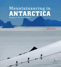
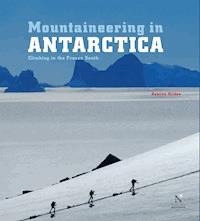
A beautiful work dedicated to mountain addicts and to amateurs who like to travel far from home!Climbing Antarctica is a unique experience. It is a dream that only few mountaineers have had the privilege to fulfill and that you can now skim, thanks to this very nice book, richly illustrated and remarkably documented.Damien Gildea will let you get be dragged into the rich history of Antarctica mountaineering adventure, from the first explorations in the 19th century until the achievements of today extreme climbers. He will lead you at the very heart of the most impressive and remote mountains of the South Pole…Discovering the incredible Antarctica Mountains, emerging from the white hugeness, will let more than one reader speechless. It is hard to figure out that we are still on Earth !In this volume you can find all the information about the Ellsworth Mountains.This book is an absolute must-have for all climbers and travellers!ABOUT THE AUTHORDamien Gidea is a polar mountaineer and explorer. He successfully led seven expeditions in the highest Antarctica Mountains, from 2001 to 2008. He is the author of the book entitled Antarctic Mountaineering Chronology, published in 1998, and of detailed topographical maps of the Livingston Island (2004) and Vinson Mountain (2006). His articles and photographs were published in many periodicals around the world, as the American Alpine Journal or the American magazine called Alpinist. He also led a skiing expedition to the South Pole and took part in several expeditions in the Himalayas, in Karakorum and in the Andes. When he is not exploring, Damien Gildea lives in Australia.EXCERPTThe Ellsworth Mountains are comprised of two main ranges: the high Sentinel Range in the north and the lower Heritage Range in the south, with the two separated by the Minnesota Glacier that runs from west to east.Sentinel rangeThe Sentinels stretch for almost 200 km like a long, jagged spine, with numerous rocky ridge shooting out to the side and sweeping down to the ice, unusually uniform in their appearance and spacing. In between these ridges lie many couloirs and big, mixed faces, some rising over 2000 m above the flat ice stretching out east and west.
Sie lesen das E-Book in den Legimi-Apps auf:
Seitenzahl: 81
Das E-Book (TTS) können Sie hören im Abo „Legimi Premium” in Legimi-Apps auf:
Ähnliche


Introduction
Climbing in Antarctica is a special experience that never fails to affect those fortunate enough to do it. For most of Antarctica’s human history this experience was restricted to those who worked as part of national government Antarctic programs, requiring great financial and logistical efforts. Visitors – and in Antarctica we are all visitors – were a small cog in a vast scientific and political machine. The scope and quality of work done by these programs has been incredible and continues to be so, providing us with critical insights into not only Antarctica but also our world as a whole. However, in purely mountaineering terms, the activity of such operations was understandably limited. Mountaineering merely enabled scientific work, with recreational climbing discouraged and usually unrecorded. In the following pages I hope to preserve at least some of those ascents, as often they have proven to be more significant to those involved than the official scientific record may indicate, and they are part of the rich human history of Antarctica that should be recorded for all to enjoy.
In general the earliest climbs were done on the Antarctic Peninsula, as it was the most accessible part of the continent and it remains popular to this day, the mountains set against the sea as beautiful as ever. As human activity spread to other parts of the land, scientific stations were established and they became bases for exploring any nearby mountains, most notably the vast Transantarctic Mountains from Scott and McMurdo bases on Ross Island. However, with the advent of private travel to inland Antarctica in the 1980s, other areas became popular solely for their value as climbing objectives. Thus the continent’s highest mountain, Mount Vinson in the Sentinel Range, has become a commercially viable destination on an annual basis and the stunning rock towers of Queen Maud Land are visited with some regularity. But other areas also contain interesting peaks, particularly the southern Transantarctics – home to Antarctica’s highest unclimbed mountains – and the relatively unexplored ranges of Alexander Island, too far down the Peninsula to sail to, not popular enough to fly to. Scattered around the continent are other worthwhile objectives, such as the big rock walls in the Ohio Ranges and Sarnoff Mountains, the remote peaks of Mac Robertson Land and, of course, the storm-swept giants rising out of the sea on South Georgia.
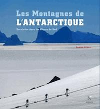
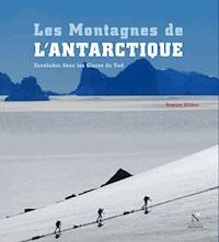
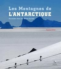
STEPHEN CHAPLIN CLIMBS HIGH ON THE WEST FACE OF MOUNT CRADDOCK, Sentinel Range, Ellsworth Mountains. Beneath, the Bender Glacier drains south into the larger Nimitz Glacier, beyond which are the smaller peaks of the Bastien Range.
No one mountain or route in Antarctica could be said to be anything greater – higher, longer, harder, steeper – than some other route or mountain on another continent. The location is the difference. There is only one Antarctica. Climbing in Antarctica is the closest that most of us will get to climbing on another planet – on Earth, but not of Earth. To walk the Vinson summit plateau is to tiptoe across the roof of a great ship adrift in an endless white sea, suspended above every other thing on the continent. You cannot walk out to a village or road, as in the Himalaya or Alaska. You can never walk home.
It would be wrong to discuss the future of the continent for Science only in the loose, emotional language of modern environmentalism, or through the selfish justifications of adventurers and sportsmen. But just as Antarctica should not be a political fiefdom for diplomats, it is more than just a giant laboratory and requires more than just science programs to ensure a safe future. We should all care about Antarctica; it is too important not to.
JED BROWN ON AN UNNAMED SUMMIT ABOVE THE EMBREE GLACIER. Behind is the dangerous northeast face of Mount Anderson, Sentinel Range, Ellsworth Mountains.
CLIMBERS AT THEIR BASE CAMP in the Orvinfjella Range, Queen Maud Land.
Climbing in Antarctica is not essential to humanity: it is a luxury. It is also a way in which we can see, understand and connect with a continent that is so important to the rest of the world. By opening up both the history and future of these faraway Antarctic mountains to a wider audience I hope that more people will come to love this place and hence care more about it.
Antarctica presents us with a challenge: to interact more responsibly with the natural environment of which we are all a part, not above. We must not damage that on which we rely for our survival, we have to make use of it without destroying it, and to share it without conflict. Our choice defines us, as will our stewardship of Antarctica.
Climbing, at its best, is about desire, passion, partnership, integrity, commitment, excellence and joy. Antarctica deserves no less.
1. Sentinel Range
2. Heritage Range
ELLSWORTH MOUNTAINS
The Ellsworth Mountains are comprised of two main ranges: the high Sentinel Range in the north and the lower Heritage Range in the south, with the two separated by the Minnesota Glacier that runs from west to east.
SENTINEL RANGE
The Sentinels stretch for almost 200 km like a long, jagged spine, with numerous rocky ridges shooting out to the side and sweeping down to the ice, unusually uniform in their appearance and spacing. In between these ridges lie many couloirs and big, mixed faces, some rising over 2000m above the flat ice stretching out east and west.
At 4892 m, Mount Vinson1 is the highest peak in Antarctica and the highest point of the Vinson Massif. A great white bulk of terrain around 15 km long by 15 km wide, it is situated roughly midway along the Sentinel Range, at the southern end of the highest section. The Massif is crowned with numerous small peaks situated around a high, windswept plateau of bare ice, from which several long ridges drop down to the surrounding glaciers. As is so often the case in other ranges around the world, the highest mountain has some relatively gentle slopes, but Vinson also has steeper faces and narrow ridges that provide more challenging climbing. North of Vinson, once Mount Shinn is passed, the range narrows dramatically to the sharp crests of Epperly, Tyree and Shear and generally stays that way until its far northern end, past Long Gables and Anderson. South of the Vinson Massif and joined to it by a high col, is the Craddock Massif, a smaller and steeper ridge-like massif containing several high points. Yet the southern end of the Craddock Massif provides a dramatic end to the high Sentinels, as once Craddock’s south face drops to the Severinghaus Glacier there is nothing higher than 4000m along a line from here all the way to the South Pole.
DAMIEN GILDEA near the summit of Mount Anderson.
Sentinel Range
1. Mount Wyatt Earp 2370 m
2. Mount Morgensen 2790 m
3. Mount Ulmer 2775 m
4. Mount Washburn 2727 m
5. Mount Crawford 2637 m
6. Mount Malone 2460 m
7. Mount Sharp 3359 m
8. Mount Dalrymple 3600 m
9. Mount Goldthwait 3813 m
10. Mount Schmid 2430 m
11. Mount Hale 3546 m
12. Mount Press 3760 m
13. Mount Bentley 4137 m
14. Mount Anderson 4144 m
15. Long Gables 4059 m
16. Mount Giovinetto 4074 m
17. Mount Jumper 2890 m
18. Mount Levack 2751 m
19. Mount Ostenso 4085 m
20. Mount Bearskin 2850 m
21. Mount Gardner 4573 m
22. Mount Tyree 4852 m
23. Mount Epperly 4508 m
24. Mount Shinn 4660 m
25. Mount Waldron 3217 m
26. Mount Vinson 4892 m
27. Mount Tuck 3588 m
28. Mount Mohl 3604 m
29. Mount Rutford 4477 m
30. Mount Benson 2184 m
31. Mount Craddock 4368 m
32. Mount Allen 3248 m
33. Mount Southwick 3087 m
FINDING ‘VINSON’
It may seem hard to believe now, but Antarctica’s highest mountains were almost completely unknown until the 1950s. In 1935 the American aviator Lincoln Ellsworth had flown over the range that was later to bear his name but it was almost totally obscured by cloud. Only a small peak at one end was visible, so he had no idea that the continent’s highest peaks lay right beneath him. He named the 2775m high peak after his wife, Mary Louise Ulmer, although now it is known simply as Mount Ulmer.
Up until 1959 the exact location of the continent’s highest point was unknown, but it had already been provisionally named ‘Vinson’, after Carl G. Vinson, Senator for the US state of Georgia, who had long been a strong supporter of US Antarctic operations. Even as late as 1959, however, there was some speculation that this ‘Vinson’ may actually lie in the area of the big volcanos in Marie Byrd Land, rather than further east in Ellsworth Land2. This speculation is believed to have originated from a flight by Richard Byrd and Paul Siple, during the 1946-47 season of Operation Highjump, when they reported seeing rocky mountain features above their plane flying at around 3000 m. Siple and others on the plane estimated that the top of the ‘mountain’ must be over 5000 m. It is now believed that this was a mistake caused by the angle of the plane flying past one of the bigger peaks of the Executive Committee Range (even though these peaks had been known by Byrd since 1934) and possibly exacerbated by previous flights that had already mistaken Mount Sidley for the elusive ‘Vinson’. The USAF had even published a chart that showed a big ‘peak’ around 77°S 124°W that people thought was either ‘Vinson’ or ‘Nimitz’, another feature whose existence had yet to be proven.
This ambiguity persisted for years, but by the late 1950s the US had begun mapping Antarctica and traverse parties set out to find and map these mythical mountains. In 1959 one such party found ‘Nimitz’, as the expedition leader, Scottish climber John Pirrit, later wrote:


