Erhalten Sie Zugang zu diesem und mehr als 300000 Büchern ab EUR 5,99 monatlich.
- Herausgeber: Nevicata
- Kategorie: Lebensstil
- Sprache: Englisch
For the first time the peaks and ranges of the world's wildest continent in one place for all to see!
This beautiful work is dedicated to mountain addicts and to amateurs who like to travel far from home, avid for discovering our planet's rare regions, which are still little known.
Climbing Antarctica is a unique experience. It is a dream that only few mountaineers have had the privilege to fulfill and that you can now skim, thanks to this very nice book, richly illustrated and remarkably documented.
Damien Gildea will let you get be dragged into the rich history of Antarctica mountaineering adventure, from the first explorations in the 19th century until the achievements of today extreme climbers. He will lead you at the very heart of the most impressive and remote mountains of the South Pole…
Discovering the incredible Antarctica Mountains, emerging from the white hugeness, will let more than one reader speechless. It is hard to figure out that we are still on Earth!
This book is an absolute must-have for all climbers and travellers!
ABOUT THE AUTHOR
Damien Gidea is a polar mountaineer and explorer. He successfully led seven expeditions in the highest Antarctica Mountains, from 2001 to 2008. He is the author of the book entitled
Antarctic Mountaineering Chronology, published in 1998, and of detailed topographical maps of the Livingston Island (2004) and Vinson Mountain (2006). His articles and photographs were published in many periodicals around the world, as the American Alpine Journal or the American magazine called Alpinist. He also led a skiing expedition to the South Pole and took part in several expeditions in the Himalayas, in Karakorum and in the Andes. When he is not exploring, Damien Gildea lives in Australia.
EXCERPT
Introduction
Climbing in Antarctica is a special experience that never fails to affect those fortunate enough to do it. For most of Antarctica’s human history this experience was restricted to those who worked as part of national government Antarctic programs, requiring great financial and logistical efforts. Visitors – and in Antarctica we are all visitors – were a small cog in a vast scientific and political machine. The scope and quality of work done by these programs has been incredible and continues to be so, providing us with critical insights into not only Antarctica but also our world as a whole. However, in purely mountaineering terms, the activity of such operations was understandably limited. Mountaineering merely enabled scientific work, with recreational climbing discouraged and usually unrecorded. In the following pages I hope to preserve at least some of those ascents, as often they have proven to be more significant to those involved than the official scientific record may indicate, and they are part of the rich human history of Antarctica that should be recorded for all to enjoy.
Sie lesen das E-Book in den Legimi-Apps auf:
Seitenzahl: 353
Veröffentlichungsjahr: 2015
Das E-Book (TTS) können Sie hören im Abo „Legimi Premium” in Legimi-Apps auf:
Ähnliche


Introduction
Climbing in Antarctica is a special experience that never fails to affect those fortunate enough to do it. For most of Antarctica’s human history this experience was restricted to those who worked as part of national government Antarctic programs, requiring great financial and logistical efforts. Visitors – and in Antarctica we are all visitors – were a small cog in a vast scientific and political machine. The scope and quality of work done by these programs has been incredible and continues to be so, providing us with critical insights into not only Antarctica but also our world as a whole. However, in purely mountaineering terms, the activity of such operations was understandably limited. Mountaineering merely enabled scientific work, with recreational climbing discouraged and usually unrecorded. In the following pages I hope to preserve at least some of those ascents, as often they have proven to be more significant to those involved than the official scientific record may indicate, and they are part of the rich human history of Antarctica that should be recorded for all to enjoy.
In general the earliest climbs were done on the Antarctic Peninsula, as it was the most accessible part of the continent and it remains popular to this day, the mountains set against the sea as beautiful as ever. As human activity spread to other parts of the land, scientific stations were established and they became bases for exploring any nearby mountains, most notably the vast Transantarctic Mountains from Scott and McMurdo bases on Ross Island. However, with the advent of private travel to inland Antarctica in the 1980s, other areas became popular solely for their value as climbing objectives. Thus the continent’s highest mountain, Mount Vinson in the Sentinel Range, has become a commercially viable destination on an annual basis and the stunning rock towers of Queen Maud Land are visited with some regularity. But other areas also contain interesting peaks, particularly the southern Transantarctics – home to Antarctica’s highest unclimbed mountains – and the relatively unexplored ranges of Alexander Island, too far down the Peninsula to sail to, not popular enough to fly to. Scattered around the continent are other worthwhile objectives, such as the big rock walls in the Ohio Ranges and Sarnoff Mountains, the remote peaks of Mac Robertson Land and, of course, the storm-swept giants rising out of the sea on South Georgia.
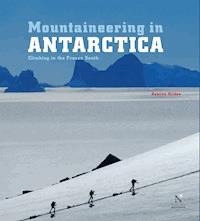
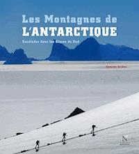
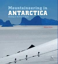
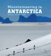
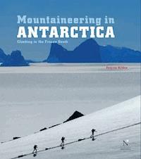
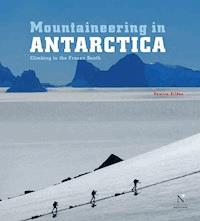
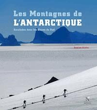
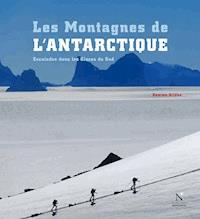
STEPHEN CHAPLIN CLIMBS HIGH ON THE WEST FACE OF MOUNT CRADDOCK, Sentinel Range, Ellsworth Mountains. Beneath, the Bender Glacier drains south into the larger Nimitz Glacier, beyond which are the smaller peaks of the Bastien Range.
No one mountain or route in Antarctica could be said to be anything greater – higher, longer, harder, steeper – than some other route or mountain on another continent. The location is the difference. There is only one Antarctica. Climbing in Antarctica is the closest that most of us will get to climbing on another planet – on Earth, but not of Earth. To walk the Vinson summit plateau is to tiptoe across the roof of a great ship adrift in an endless white sea, suspended above every other thing on the continent. You cannot walk out to a village or road, as in the Himalaya or Alaska. You can never walk home.
It would be wrong to discuss the future of the continent for Science only in the loose, emotional language of modern environmentalism, or through the selfish justifications of adventurers and sportsmen. But just as Antarctica should not be a political fiefdom for diplomats, it is more than just a giant laboratory and requires more than just science programs to ensure a safe future. We should all care about Antarctica; it is too important not to.
JED BROWN ON AN UNNAMED SUMMIT ABOVE THE EMBREE GLACIER. Behind is the dangerous northeast face of Mount Anderson, Sentinel Range, Ellsworth Mountains.
CLIMBERS AT THEIR BASE CAMP in the Orvinfjella Range, Queen Maud Land.
Climbing in Antarctica is not essential to humanity: it is a luxury. It is also a way in which we can see, understand and connect with a continent that is so important to the rest of the world. By opening up both the history and future of these faraway Antarctic mountains to a wider audience I hope that more people will come to love this place and hence care more about it.
Antarctica presents us with a challenge: to interact more responsibly with the natural environment of which we are all a part, not above. We must not damage that on which we rely for our survival, we have to make use of it without destroying it, and to share it without conflict. Our choice defines us, as will our stewardship of Antarctica.
Climbing, at its best, is about desire, passion, partnership, integrity, commitment, excellence and joy. Antarctica deserves no less.
1. Sentinel Range
2. Heritage Range
ELLSWORTH MOUNTAINS
The Ellsworth Mountains are comprised of two main ranges: the high Sentinel Range in the north and the lower Heritage Range in the south, with the two separated by the Minnesota Glacier that runs from west to east.
SENTINEL RANGE
The Sentinels stretch for almost 200 km like a long, jagged spine, with numerous rocky ridges shooting out to the side and sweeping down to the ice, unusually uniform in their appearance and spacing. In between these ridges lie many couloirs and big, mixed faces, some rising over 2000m above the flat ice stretching out east and west.
At 4892 m, Mount Vinson1 is the highest peak in Antarctica and the highest point of the Vinson Massif. A great white bulk of terrain around 15 km long by 15 km wide, it is situated roughly midway along the Sentinel Range, at the southern end of the highest section. The Massif is crowned with numerous small peaks situated around a high, windswept plateau of bare ice, from which several long ridges drop down to the surrounding glaciers. As is so often the case in other ranges around the world, the highest mountain has some relatively gentle slopes, but Vinson also has steeper faces and narrow ridges that provide more challenging climbing. North of Vinson, once Mount Shinn is passed, the range narrows dramatically to the sharp crests of Epperly, Tyree and Shear and generally stays that way until its far northern end, past Long Gables and Anderson. South of the Vinson Massif and joined to it by a high col, is the Craddock Massif, a smaller and steeper ridge-like massif containing several high points. Yet the southern end of the Craddock Massif provides a dramatic end to the high Sentinels, as once Craddock’s south face drops to the Severinghaus Glacier there is nothing higher than 4000m along a line from here all the way to the South Pole.
DAMIEN GILDEA near the summit of Mount Anderson.
Sentinel Range
1. Mount Wyatt Earp 2370 m
2. Mount Morgensen 2790 m
3. Mount Ulmer 2775 m
4. Mount Washburn 2727 m
5. Mount Crawford 2637 m
6. Mount Malone 2460 m
7. Mount Sharp 3359 m
8. Mount Dalrymple 3600 m
9. Mount Goldthwait 3813 m
10. Mount Schmid 2430 m
11. Mount Hale 3546 m
12. Mount Press 3760 m
13. Mount Bentley 4137 m
14. Mount Anderson 4144 m
15. Long Gables 4059 m
16. Mount Giovinetto 4074 m
17. Mount Jumper 2890 m
18. Mount Levack 2751 m
19. Mount Ostenso 4085 m
20. Mount Bearskin 2850 m
21. Mount Gardner 4573 m
22. Mount Tyree 4852 m
23. Mount Epperly 4508 m
24. Mount Shinn 4660 m
25. Mount Waldron 3217 m
26. Mount Vinson 4892 m
27. Mount Tuck 3588 m
28. Mount Mohl 3604 m
29. Mount Rutford 4477 m
30. Mount Benson 2184 m
31. Mount Craddock 4368 m
32. Mount Allen 3248 m
33. Mount Southwick 3087 m
FINDING ‘VINSON’
It may seem hard to believe now, but Antarctica’s highest mountains were almost completely unknown until the 1950s. In 1935 the American aviator Lincoln Ellsworth had flown over the range that was later to bear his name but it was almost totally obscured by cloud. Only a small peak at one end was visible, so he had no idea that the continent’s highest peaks lay right beneath him. He named the 2775m high peak after his wife, Mary Louise Ulmer, although now it is known simply as Mount Ulmer.
Up until 1959 the exact location of the continent’s highest point was unknown, but it had already been provisionally named ‘Vinson’, after Carl G. Vinson, Senator for the US state of Georgia, who had long been a strong supporter of US Antarctic operations. Even as late as 1959, however, there was some speculation that this ‘Vinson’ may actually lie in the area of the big volcanos in Marie Byrd Land, rather than further east in Ellsworth Land2. This speculation is believed to have originated from a flight by Richard Byrd and Paul Siple, during the 1946-47 season of Operation Highjump, when they reported seeing rocky mountain features above their plane flying at around 3000 m. Siple and others on the plane estimated that the top of the ‘mountain’ must be over 5000 m. It is now believed that this was a mistake caused by the angle of the plane flying past one of the bigger peaks of the Executive Committee Range (even though these peaks had been known by Byrd since 1934) and possibly exacerbated by previous flights that had already mistaken Mount Sidley for the elusive ‘Vinson’. The USAF had even published a chart that showed a big ‘peak’ around 77°S 124°W that people thought was either ‘Vinson’ or ‘Nimitz’, another feature whose existence had yet to be proven.
This ambiguity persisted for years, but by the late 1950s the US had begun mapping Antarctica and traverse parties set out to find and map these mythical mountains. In 1959 one such party found ‘Nimitz’, as the expedition leader, Scottish climber John Pirrit, later wrote:
‘… according to the map, Vinson should be on our left towering about 14,000ft above the snow level… no sign of anything, must have passed over the spot where Mt. Nimitz supposed to be… nothing…. mountains ahead must be peaks of the Executive Committee Range.’
LOOKING SOUTH FROM THE SUMMIT OF MOUNT BENTLEY. The obvious large rocky face left of centre is the north face of Mount Tyree with the summit of Mount Shinn visible to the left. Right of Tyree is the summit of Mount Gardner.
THE SENTINEL RANGE FROM THE NORTHEAST. Left to right are visible the main peaks of Vinson, Shinn, Tyree, Gardner, Giovinetto and Anderson.
Pirrit then climbed to around 3650m on one of these peaks, later shown to be Mount Sidley, which at 4285m is the highest of the Executive Committee Range, as well as summiting and surveying three smaller peaks to the north. But still no ‘Vinson’.
However, in January 1958 a USN flight from Byrd Station had sighted high mountains further east in Ellsworth Land3. During the 1958-59 season another traverse party driving Tucker Sno-Cats headed in this direction and found a great mountain massif, which when surveyed seemed to be higher at its highest point than anything else yet seen in Antarctica. At last, Vinson had been found. One of the members of that traverse was a young glaciologist named Bill Long, who would return seven years later to stand on that highest point. More scientific parties visited the area in the early 1960s and even made a few minor ascents. The first mountain climbed in the range was Mount Wyatt Earp (2370 m) in December 1961 by US geologists Trevor Bastien and John Splettstoesser, who had climbed the lower Howard Nunataks (c.1800 m) the week before. In the 1963-64 season a team from the University of Minnesota conducted work in the area and one member, a young geologist and keen climber named John Evans, was even offered a helicopter ride to the summit of Vinson, which he declined. Evans, like Long, was destined to return.
POLITICS & PLANS
Now that Vinson had been confirmed as Antarctica’s highest mountain, interest in climbing it naturally began to grow. This was particularly so in the United States, where two separate groups of experienced climbers, one based on the east coast and the other based in the Pacific northwest, had been making informal plans to attempt Vinson. Yet they had met with no success, particularly with regard to the main obstacle: the huge logistical effort to access inland Antarctica. The US Antarctic authorities had already established what would become a permanent policy stance: their facilities, personnel and logistical capabilities were for science, not sport. However, a rogue element was set to force their hand.
In 1962, Woodrow Wilson Sayre, a well-connected New Englander and grandson of former US President Woodrow Wilson, made a daring lightweight attempt on Mount Everest. Gaining a permit for the nearby Gyachung Kang (7952 m), Wilson and his three team mates gained the Nepal-Tibet border pass of the Nup La with the help of Sherpas, but then diverted back down east into the western arm of the Rongbuk Glacier. Travelling light and relaying loads, they reached the main Rongbuk and turned into the eastern arm, gaining the old pre-WWII advance base camp of the British expeditions to the north ridge. They were defeated at the North Col and returned unscathed back the way they had come. Their adventure was understandably frowned upon in Nepal and caused something of a diplomatic incident that threatened the upcoming 1963 American Everest Expedition, which would eventually go on to make the first ascent of Everest’s difficult west ridge. Sayre’s raid, later recounted in the book Four Against Everest, was temporarily covered up by the authorities, but not forgotten. Now, a couple of years later, Sayre was making plans for Vinson and was even reported to have hired a pilot and plane to fly there. The US government heard of the plans and decided to step in, to pre-empt the situation and repel Sayre and any others that they now realised may try to do something similar. In fact the famous Austrian climber Heinrich Harrer also planned a Vinson expedition and even enquired as to the possibility of obtaining logistical help when he visited the McMurdo base as a guest in 1961.
The authorities approached the American Alpine Club with a proposal to support a team of American climbers to climb Vinson and contact was made with the two groups who had already shown interest. To avoid potential conflict it was decided to choose a leader from outside these two groups and so Nicholas Clinch was approached. Clinch, a lawyer from California, had already led two major American mountaineering expeditions with great success. In 1958 he led a team to attempt the 8068m high Gasherbrum I (Hidden Peak) in the Karakoram range, Pakistan. The expedition put Andy Kaufmann and Pete Schoening on the summit, which was the first American ascent of an 8000m peak and eventually the only 8000er to have had its first ascent by Americans. In 1960 Clinch returned to Pakistan, leading a team on the first ascent of Masherbrum (7821 m), the twenty-second highest mountain in the world.
The US authorities were open about wanting to ‘spoil the prize’, as Clinch later put it, so that no one else would want to go to Antarctica for Vinson. In fact, on seeing photos of the highly impressive-looking Tyree and realising climbers would find it irresistible, one senior Navy official suggested that the team should climb it as well, just to be sure! As it transpired, in addition to their summit success, the resulting expedition could also be seen as successful, as no non-government climbers tried to set foot on Vinson for nearly 17 years.
Despite the scientific visits made to the lower Sentinels in the early 1960s, Vinson as a climbing objective in 1966 was a complete unknown. In contrast, by 1966 all of Asia’s fourteen 8000m peaks had been climbed. In fact, Mount Everest had been climbed by 24 people, from five expeditions, via three different routes. More people had stood atop Everest than had even set foot in the Sentinel Range.
1966 - THE FIRST ASCENT
Clinch’s team was strong and experienced. John Evans had already visited the Sentinel Range as a geologist in 1961-62 with a team from the University of Minnesota, but he is probably better known for making the first ascent of the stupendous Hummingbird Ridge on Canada’s highest peak, Mount Logan (5959 m), in 1965. Evans made an early ascent of The Nose on Yosemite’s El Capitan and would later go on major expeditions to the southwest face of Everest in 1971 and the ill-fated 1976 expedition to Nanda Devi (7816 m), as well as pioneering a route on the west face of Alaska’s beautiful Mount Huntington (3731 m). The glaciologist Bill Long, then living and teaching in Alaska, had also worked in Antarctica and had been in the Vinson area. In 1958 he made the first ascent of Mount Glossopteris (2865 m) in the remote Ohio Range, and the leaf fossils found there helped strengthen the case for the theories of tectonic plates, continental drift and the existence of the supercontinent Gondwana. Brian Marts – at 23 the team’s youngest member – and Barry Corbet were both professional climbing guides, and Corbet had been on the famous 1963 American Everest Expedition that made the first ascent of the mountain’s west ridge. Peter Schoening from Seattle was already famous in the climbing world, not only for his first ascent of Hidden Peak and a new route on Mount Logan, but for saving four of his team mates on K2 (8611 m) in 1954 when he held their fall with just an ice axe belay. Sam Silverstein, the team doctor, and Charles Hollister had been on the 1954 first ascent of the huge southeast spur of Mount McKinley (6194 m) in Alaska, while Eiichi Fukushima and Richard Wahlstrom were climbing instructors at the University of Washington in Seattle.
ONE OF THE PENNANTS OF THE 1966-67 AMERICAN ANTARCTIC MOUNTAINEERING EXPEDITION. This pennant was left on the summit of Mount Gardner in January 1967 and retrieved by Mugs Stump in 1989.
They all flew to Christchurch, New Zealand, from where the United States bases its Antarctic program with flights to the McMurdo base on Ross Island and onward to the South Pole. In Christchurch the team obtained all their expedition food, greatly assisted by Norman Hardie, the climber who made the first ascent of the world’s third highest mountain Kangchenjunga (8586 m) in 1955 and who had been a former leader of the NZ Scott Base on Ross Island. After a brief stop at McMurdo the team flew straight to the range but could not land due to poor visibility, so diverted to Byrd Station where they waited for 10 hours. On December 8th they eventually landed a ski-equipped LC-130 on the flat ice around 20 km west of the main peaks. From here they used a snowmobile to carry their supplies closer to the mountain, though they were forced to do a short stint of manhauling as the fuel for the machines, dropped on a previous flight, could not initially be located.
Sam Silverstein had identified a narrow gap in the ridge that runs down southwest from Mount Shinn as a possible entry point to the actual slopes of Vinson itself. The climbers soon reached this gap, naming it ‘Sam’s Col’, and fixed ropes up it to carry loads to the next stage. Crossing the basin of the upper Branscomb Glacier beyond, the team ascended the headwall to what is now Goodge Col and set a camp. Setting off on December 18th Barry Corbet, John Evans, Bill Long and Pete Schoening soon reached the summit, where they took photographs with the flags of the 12 original signatories of the Antarctic Treaty arranged in a circle. The rest of the team would summit Vinson over the next two days. The prize had been spoiled! In the few days before Christmas the team then turned to the nearby Mount Shinn, again summiting in three groups over three days.
PETE SCHOENING AND JOHN EVANS on the summit of Mount Vinson, December 18th 1966.
BARRY CORBET on the summit of Mount Tyree, Antarctica’s second-highest mountain, January 5th 1967.
BARRY CORBET high on the northwest ridge of Mount Tyree during the first ascent.
BRIAN MARTS climbing high on the northwest ridge of Long Gables during the first ascent, January 1967.
The whole group then moved north and started up the obvious couloir at the northern end of Mount Gardner’s long west face. Fixing ropes in the couloir, they placed a camp on a rocky platform near the top, before traversing along and across the vast undulating plateau to set a camp at around 4100m on the upper eastern side of Gardner. From here Evans and Marts summited first, on New Year’s Eve, followed by all the others except Corbet. However, the great challenge of Tyree looms to the north above this high camp, a steep rocky pyramid separated from Gardner by a narrow ridge. Many in the team were intimidated by the thought of attempting Tyree, so it was never a sure thing. They realised they would need a forward camp closer to Tyree itself, which meant finding a way from high on Gardner down and onto the ridge leading to Tyree. The first attempt ended in Evans and Corbet dangling out of a bottomless gully high over the huge east face. The eventual route went almost to the summit of Gardner but then dropped off down the upper east face to the snowy slopes on the east side of the ridge. This was fixed with ropes and Fukushima, Long and Marts helped set and supply a camp to launch Corbet and Evans onto Tyree. Again, an initial attempt failed, when they tried to follow the crest of the ridge from their camp along to Tyree. They then realised they could move along the snow under the ridge and gain a small couloir that cut back up onto Tyree’s northwest ridge where it starts to rise. Following this they gained the ridge but actually climbed for much of the time on the upper west face where the climbing was never difficult but challenging and very exposed. On January 5th 1967 Corbet and Evans reached the summit of Tyree, the grand prize and far and away the hardest climb in Antarctica up to that time. The pair retraced their route down the ridge, unroping for much of it, and reached their camp after a momentous 22 hours. On the way back over Gardner they even diverted to allow Corbet to stand on Gardner’s summit, the only member not to have done so by then.
Less than a week later the whole team was once again travelling north along the flat ice to squeeze a couple more climbs in before they left, thinking they would never get the chance to return. Two attempts were made on the long west ridge of Long Gables before a third saw them finally reach the summit. Fukushima, Long, Marts and Schoening climbed the ridge and traversed onto the upper north face to circle around to the summit, a long single push giving sustained and exposed climbing second only to Tyree in difficulty. At the same time, Hollister and Silverstein, who had been about to attempt Mount Giovinetto, joined Evans and Wahlstrom to make the first ascent of Mount Ostenso, climbing the moderate snow slope on the northwest side to reach an airy whipped-cream summit.
So ended one of the most successful mountaineering expeditions of all time. A single team had arrived in an unknown range, climbing not only the highest mountain on the continent, with all members summiting, but also reaching the summits of the second, third and fourth highest peaks as well, with a couple of other high summits thrown in for good measure. It was an incredible achievement. Corbet and Evans became the first people to climb Antarctica’s three highest mountains, a feat not equalled for over two decades, when they were eventually climbed again by Conrad Anker.
1979 - A STOLEN SUMMIT & THE MYSTERY FLAG
Vinson Massif was not visited again for 13 years, when a US scientific party led by Professor Campbell Craddock based itself to the south of the range, on the Minnesota Glacier. The party also included three international guests: geologists Peter von Gizycki and Werner Buggisch from West Germany, and Victor Samsonov from the Soviet Union. These three needed to do fieldwork low on the mountain and were instructed not to go for the summit. Yet after being dropped by helicopter at a base west of ‘Sam’s Col’, they could not resist the urge to climb Antarctica’s highest peak and reached the summit on December 22nd 1979, by the route of first ascent. Samsonov rammed his ski pole into the snow on the summit – it remained there until 2007 – and tied a small, red USSR flag to it. A US survey team far out on the ice to the southeast could actually make out the flag with their instruments, and in so doing were fortuitously able to produce a more accurate height for Vinson than had been previously calculated. Thus the height of Vinson was adjusted from 5140m down to 4897 m, though the older figure erroneously appeared on some maps for years afterwards. The unauthorised ascent of Vinson caused some controversy within the US program.
IN DECEMBER 2006 FOR THE 40TH ANNIVERSARY OF VINSON’S FIRST ASCENT Eiichi Fukushima, John Evans, Sam Silverstein and Brian Marts returned to Vinson Base Camp.
GERMAN SCIENTIST AND CLIMBER PETER VON GIZYCKI with the State Flag of Alaska that he found on the summit of Vinson in 1979.
As a sidenote, the three also made an error that would be repeated occasionally in following years. Ascending the shallow valley up to the main summit, they initially thought a similar peak to the east of Vinson was actually the main summit. However, upon reaching its top they saw the higher peak to the west and, realising their error, moved across to climb the true high point. In fact, the 1966 Vinson first ascent team had wondered if they were actually on the highest point and several of them secretly feared for years – unnecessarily of course – that they had made a giant mistake! This peak was erroneously climbed in 1989 and then deliberately climbed again in 1992. The latter team of Britons thought they had made a first ascent and named it ‘Kershaw Peak’, after Giles Kershaw, who had been killed not long before in a gyrocopter accident on the Antarctic Peninsula. However, as Kershaw already had a feature named after him, the USGS rejected it and adopted the British climbers’ second suggestion, Sublime Peak, which is now the official name.
On the summit von Gizycki found a blue flag, half-covered in snow. Though ripped and somewhat faded, a few stars could be made out, leading the trio to believe they had found the Australian flag left on the summit by the 1966 first ascent team, who had left a flag of each of the 12 member nations of the Antarctic Treaty at that time. Some years later von Gizycki was in contact with John Evans and mentioned the flag. Seeing a photo of it, Evans did not think it was the flag they had left on the summit. On reviewing his June 1967 National Geographic von Gizycki realised that his flag was indeed noticeably larger than the 12 national flags left in a circle by the Americans.
So who had left the flag? Had an Australian climber secretly ascended Vinson in the years between 1967 and 1979? Such an outlandish feat seemed the only possible answer, and caused numerous discussions amongst those involved. In an attempt to solve the mystery of the flag, Damien Gildea travelled to Germany in February 2003 to interview Peter von Gizycki and photograph the flag in more detail, and he also corresponded further with Evans and others. Then, in 2004, Evans mentioned the flag to Bill Long, the other geologist on the first ascent of Vinson. Long remembered that he had in fact taken, and planted on the summit, an extra, more personal flag. It was this flag, and only this flag, that had survived 13 years on the roof of Antarctica: the state flag of Alaska.
1983 – VINSON AS THE SEVENTH SUMMIT
The next person to touch Samsonov’s ski pole was the famous British climber Chris Bonington. He had been invited on a bold expedition organised by the wealthy US pair of Dick Bass and Frank Wells, who had embarked on an odyssey to climb the highest point on each continent. The challenge would become known as the Seven Summits and revolutionised private travel to Antarctica. Bass and Wells chartered a DC-6 and the experienced British polar pilot Giles Kershaw to fly them, Bonington, Rick Ridgeway, Steve Marts and two Japanese climbers to Vinson from Punta Arenas, Chile, via the Antarctic Peninsula and using fuel caches placed with assistance from the Chilean government. Legendary Italian mountaineer Reinhold Messner had wanted to join the group but Bass and Wells refused, as it would have led to Messner becoming the first person to complete the Seven Summits.
The Bass and Wells group used the same route as the 1966 and 1979 ascents, but on the first attempt, on November 23rd, all except Bonington were turned back by high winds and the brutal cold. Bass, Wells, Ridgeway and Marts summited a week later. This was the first time Vinson had been climbed as one of the Seven Summits and the first time it had been climbed without government assistance south of the Peninsula.
High Sentinels
1. Knutzen Peak 3373 m
2. Branscomb Peak 4520 m
3. 4753 m
4. Sublime Peak 4865 m
5. Corbet Peak 4822 m
6. Schoening Peak 4743 m
7. Clinch Peak 4841 m
8. Marts Peak 4551 m
9. Silverstein Peak 4790 m
10. Hollister Peak 4729 m
11. Wahlstrom Peak 4677 m
12. Fukushima Peak 4634m
1. Vinson Base Camp 2100m
2. Low Camp 2800 m
3. High Camp 3775 m
4. Shinn Camp 3700 m
5. Old Vinson Base Camp (1966-1993)
Main routes
THE WEST FACE OF MOUNT VINSON above the Branscomb Glacier.
1985 - ADVENTURE NET WORK INTERNATIONAL
Through 1984 and 1985 Canadian climber Pat Morrow was planning to climb Vinson to complete his own version of the Seven Summits quest, which included Carstenz Pyramid (4884 m) in Indonesia’s West Papua province (formerly Irian Jaya) instead of the much lower and easier Kosciuszko (2228 m) in Australia. Morrow brought together people from various areas to form the expedition team, but an attempt in 1984 via Ushuaia failed due to engine trouble. However, in late 1985 Giles Kershaw once again flew down the Peninsula from Chile and they reached the mountain. This required no small amount of political negociation and diplomacy with the Chilean authorities, but the resulting relationships formed the basis for operations that last to this day.
Morrow was on the flight and his November 19th summit of Vinson made him the first person to do the ‘Carstenz set’ of the Seven Summits. The Canadian-resident British climber Martyn Williams was also there and with Morrow he made the first ski descent of Vinson. Morrow, Williams and Kershaw would continue the operation for several years, taking climbers to Vinson and other adventurers to inland Antarctica under the name Adventure Network International (ANI). Also on that flight was US businessman Steve Fossett, who would go on to break world ballooning records but tragically died during a routine plane flight in 2007. Part of the deal with the Chilean authorities, who consider the Ellsworths to be in their sovereign territory as part of their Antarctic claim, was that the expedition must include a Chilean national. Hence a young climber from Santiago joined the team. Alejo Contreras Staeding went on to make numerous ascents of Vinson over the following years as a guide and has worked in support for many other major Antarctic expeditions since then. A month later a second flight went in, carrying some of ANI’s first ‘celebrity’ clients: the outdoor entrepreneurs Yvon Chouinard and Doug Tompkins, as well as Gerry Roach and Glen Porzak. Roach became the second person to do the ‘Kosciuszko set’, with Porzak not far behind.
From the 1986-87 season the number of clients grew, most of them in the process of completing the Seven Summits, a concept that was then considered relatively new and adventurous. Others came simply to experience a new adventure, taking advantage of these new logistics that opened up a part of the planet that had before seemed almost impossibly inaccessible. Messner finally reached his seventh summit in 1986, and in 1988 the American guides Phil Ershler and Vern Tejas began guiding clients up Vinson, a job they continue to do independently some 20 years later.
THE HUGE SOUTHWEST FACE OF MOUNT EPPERLY showing the 1994 Loretan route of first ascent (left) and the 2007 Gildea-Rada line The Fifth Element (right).
Vinson Records
First Ascent: Barry Corbet, John Evans, Bill Long, Pete Schoening (USA) Dec 18th 1966
First Solo Ascent: Vern Tejas (USA) 1988 – 1966 Route
First New Route1: Rudi Lang (GER) 1991 – West Face Ice Stream Left – Rudi’s Runway
First Ski Descent: Pat Morrow & Martyn Williams (CAN) 1985
First Snowboard Descent: Stephen Koch (USA) 1999
First Paraglider Descent: Vern Tejas (USA) 1988
First Female Ascent: Lisa Densmore (USA) 1988
First Female Solo Ascent: Heather Morning (UK) Jan 2004
First Complete Female Ski Descent2: Kit DesLauriers (USA) Nov 2005
Youngest Summiter: John Strange (USA) – 12 years old – Dec 2004
Most Ascents: 26 by Dave Hahn (USA) as of 2010 Fastest Ascent: Conrad Anker (USA) – 9 hours 10 minutes return – 1998
Note:
1 At least one variant to the 1966 route was climbed before this date. It passed between the upper Branscomb Glacier and a high camp and was similar to the current normal route. There are also rumours of an ascent of a new route on the west face by Mugs Stump in the 1988-89 season.
2 After her solo ascent in January 2004, Heather Morning descended all but a very short section at the top of the headwall beneath Goodge Col on skis.
1989 - MUGS, TYREE & GARDNER
Non-ANI visitors to the range were rare even by this time, but geologists Ed Stump (US) and Paul Fitzgerald (NZ) had work to do in the area. Their field assistants were Ed’s brother Mugs, already one of America’s finest alpinists, and the New Zealand guide Rob Hall. All made an ascent of Vinson and Hall even soloed a route on the south face of Shinn above Goodge Col. Ed Stump left the team early with minor frostbite, but the rest remained, at one point using their snowmobiles to help rescue stricken ANI climbers on Vinson. However Mugs, against the very specific policies of his employment with the National Science Foundation (NSF), could not resist testing his skills on the huge faces above their base camp. The team had discussed the impressive 2000m high southwest face of Mount Gardner and it was up this that Mugs first launched. Joining two shallow couloirs, broken by a short rock section, Mugs reached the summit – the first person to do so for nearly 23 years – where he found a pennant left by the first ascent team in 1967. Days later he repeated the style, but on the bigger west face of Mount Tyree, climbing the giant mixed face for over 2300m of vertical gain. Mugs descended the original 1967 Corbet-Evans route along the northwest ridge and continued down over Gardner in a total time of around 12 hours! In the land of massive logistics and the safety first principle, Mugs had epitomised the Alpine ideal of doing more with less, but took it to an extreme degree and with great élan. The NSF was not happy with the relatively minor publicity these climbs received. Yet there was no doubt that Mugs had single-handedly raised the bar of Antarctic alpinism to a level that would not be equalled for nearly a decade; if in fact it has been equalled at all, given the boldness and style he showed at the time. Two years later Mugs was killed in a crevasse fall whilst guiding on Mount McKinley.
THE 1990s
This decade saw a huge growth in the number of guided groups climbing Vinson, but only occasional ascents of other peaks. German climber Rudiger Lang was the first to climb one of the ‘ice stream’ routes on Vinson’s west face, taking the most direct line up the left side of the main stream in January 1991, a route now known as Rudi’s Runway. In December 1992 Conrad Anker and Jay Smith arrived on the Gildea Glacier – which was then unnamed and untrodden – guiding several clients up the first ascent of Vinson’s south face, stopping just short of the main summit but naming the route From The Heart. Anker and Smith then crossed into the Bender and Severinghaus Glaciers to attempt the huge south face of Mount Craddock (4368 m) but retreated due to avalanche danger. Returning to the Gildea Glacier the pair bagged the first ascent of Craddock, via a spur on the west side. Craddock was thought at the time to be the sixth highest mountain in Antarctica, based on an inaccurate height of 4650m accompanying it on the USGS map. This was the first expedition to the Sentinels for Anker, but he would go on to become one of the most significant figures in the history of climbing in the range. Also in this group were another two Americans, Robert Anderson and Joseph Blackburn. Anderson soloed the first ascents of both a new route on Vinson’s south face and a second route up the southwest ridge, both done in long single pushes.
The 1993-94 season saw Jay Smith return to Vinson. With his then-wife Jo, he made the first ascent of the right-hand ice stream that comes down from Silverstein Peak, naming the route Heavenly Father. A month later Jay soloed the first route to breach the main west face of Vinson. Linear Accelerator took an obvious straight couloir in the centre of the face and exited at the top just north of Branscomb Peak.
Though it towered over the old site of Vinson BC, Mount Epperly was one of the highest unclimbed mountains in Antarctica and also one of the steepest. In November 1994 the Swiss alpinist Erhard Loretan climbed on Vinson and Shinn, then descended to the basin beneath Epperly. After one aborted attempt Loretan soloed the stunning narrow ice gully that splits the south face, finding it more difficult than he expected, with loose overhanging rock at the top of the couloir. The next month a Spanish expedition climbed two lines beneath Silverstein Peak. One finished at the small rock promontory west of the peak, a point they named ‘Pico Principe de Asturias’ after their home province. The same team attempted the first ascent of Silverstein itself, which was then unnamed and referred to by them as ‘Monte España’. They took the broad couloir to the right of the 1993 Smith route but retreated well short of the summit. The team also made an ascent of the small rocky summit on the western bank of the Branscomb, naming it ‘Pico Jaca’. This peak gives a fantastic view of the west side of the Vinson Massif, but had been climbed numerous times before and was re-named Knutzen Peak by the USGS in 2006.
The 1995-96 season turned out to be both productive and dramatic. On December 29th Loretan returned to repeat the Epperly climb for a film shot by Romolo Nottaris. After this he headed north, alone again, and made the first ascent of the high peak immediately south of Mount Tyree. The peak is just over 4500m high and has a big west face, much like all the big Sentinels nearby, but Loretan raced up a narrow couloir that ascends almost the entire height of the face reaching the ridge just to the south of the summit. Some commentators named this summit ‘Peak Loretan’ though Erhard never suggested the name himself. December 1995 was also notable because the first climbers visited the Patton Glacier on the east side of the range. Rob Hall and Ralf Dujmovits had considered attempting Tyree from this side, but felt the conditions were not safe. Instead they guided clients up two smaller virgin peaks nearby, Mount Bearskin (2850 m) and Mount Jumper (2890 m).
But the season ended in dramatic fashion. On January 11th the French husband-and-wife team of Erik Decamp and Catherine Destivelle bypassed Vinson completely and flew north. They made the first ascent of Mount Viets (c.3700 m), a small pyramidal peak just north of Mount Giovinetto, via its south face. Two days later they set off up the south face of the virgin Peak 4111, the southern summit of Long Gables. Finding terrain similar to the north face of the Matterhorn, they moved unroped for most of the climb but tied in for the last 200m and reached the summit ridge without problem. However, whilst taking photos on the summit, Destivelle lost her footing on poor snow and fell backwards, somersaulting down the slope before coming tight on the rope. She only fell around 20 m, but landed on hard ice with protruding rocks. She had broken her leg, the open fracture bleeding into her boot, and had also injured her shoulder and elbow but could still use her arm. For a less capable party in this situation, such an injury might have been a death sentence but Decamp managed to lower Destivelle down the 1600-metre face that they had climbed, using only a 50m rope. The necessary traverses were particularly difficult but fortunately Destivelle could use both arms and was able to rig the many belays. Upon reaching the bottom of the face Decamp rushed back to their camp to retrieve a sled, which he then used to drag Destivelle back to the tent. They only had a very basic first aid kit with no strong painkillers. She said later that, given their position, she would not have taken any painkillers anyway, so as to remain fully lucid. To make matters worse, poor weather prevented a plane being sent from Patriot Hills, so they had a desperate three-day wait before their eventual evacuation.
CLIMBERS HIGH ON THE SOUTHWEST FACE ROUTE OF MOUNT SHINN, Antarctica’s third-highest mountain. The route continues up through the gap in the seracs above.
Vinson Routes
A. Mount Shinn 4660 m
B. Mount Farrell
C. Mount Waldron 3217 m
D. Mount Havener
E. Mount Tuck 3588 m
F. Schoening Peak 4743 m
G. Mount Vinson 4892 m
H. Clinch Peak 4841 m
I. Wahlstrom Peak 4677 m
J. Hollister Peak 4729 m
K. Silverstein Peak 4790 m
L. Fukushima Peak 4634m
M. Asturias Peak
N. Branscomb Peak 4520 m
O. Knutzen Peak 3373 m
1. Vinson Normal Route 2007
1a. Headwall Route 1966-2007
2. Vinson West Ridge - Anker 1997
3. Asturias Route - Alvarez/Huez 1997
4. Heavenly Father - Smith/Bentley 1993
5. Ice Stream Right Side - Anker 1998
6. Rudi’s Runway - Lang 1991
7. Banana Friendship Gully - Vidal 2004
8.


