Erhalten Sie Zugang zu diesem und mehr als 300000 Büchern ab EUR 5,99 monatlich.
- Herausgeber: The History Press
- Kategorie: Lebensstil
- Sprache: Englisch
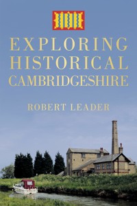
This fascinating and beautifully photographed guidebook follows Cambridgeshire's waterways from leafy Huntingdon to the wide-sky Fens, along the lovely Nene Valley down to the busy port town of Wisbech and travels beside the gentle stream of the Cam into the architectural glories of the university city of Cambridge. The narrative explores the history of Cambridgeshire through its vanished castles and abbeys, and traces the draining of the wild marshes. Cambridgeshire is a county that is different to any other in England, and the watery landscapes of the Fens are unique. From the bizarre Straw Bears that lead the hosts of morris dancers through the heart of Whittlesey every January, to the sedate Rose Fair that graces Wisbech church and gardens every June, Cambridgeshire has something to offer everyone.
Sie lesen das E-Book in den Legimi-Apps auf:
Seitenzahl: 188
Veröffentlichungsjahr: 2014
Das E-Book (TTS) können Sie hören im Abo „Legimi Premium” in Legimi-Apps auf:
Ähnliche


CONTENTS
Title Page
One: The Call of the Cam
Two: The River Ouse, St Neots to St Ives
Three: Ely and the Great Ouse
Four: Cambridgeshire Abbeys
Five: Cambridgeshire Castles
Six: The Upper Nene Valley
Seven: The Tidal Nene
Eight: The Heart of the Fens
Nine: The Age of Windmills
Ten: Village Portraits
Eleven: Chippenham – A Portrait of an Estate
Twelve: Stately Halls and Splendid Houses
Thirteen: The History of the Fens
Fourteen: War Over Cambridgeshire
Fifteen: Newmarket
Sixteen: The University City
About the Author
Plate Section
Copyright
CHAPTER ONE
THE CALL OF THE CAM
Cambridgeshire is a county of waterways, natural and man-made, creating a blue-veined jigsaw of rich greens under wide blue skies. All have their attractions, but none is as lovely, or more varied, than the Cam itself. The river winds through a gently undulating valley and farmlands, past the pinnacled, architectural glories of the city of colleges, and out into the vast flat fields of the peat-rich Fens.
There are, in fact, three rivers feeding the Cam, the Rhee flowing in past Barrington and Haslingfield from the west, the Granta flowing in through Linton and the Abingtons from the east, and the central Cam, born in Essex and flowing south to north. The Cam slides under the M11 to wriggle past the first Cambridgeshire villages of Ickleton and Hinxton.
All along the valley there are traces of Saxon, Roman, and even Neolithic occupation. The river has been fished and the land hunted and then farmed for thousands of years. Today the villages are peaceful and idyllic. Hinxton is small but delightfully photogenic. The thatched Church Green Cottages on the corner of the green contribute to a classic scene which includes the silver-spired church of St Mary and St John. Down by the river is the old white-boarded watermill, which is still opened on Sunday afternoons in the summer.
To go on to Duxford the narrow lane crosses the river by a shallow but fast-flowing ford. To most people Duxford means the magnificent Aviation Museum on the other side of the M11, but the village itself is well worth a visit. Again, the core of the old village is a charming little green, in sight of another church dedicated to St John, shaded by trees and surrounded by old cottages, some thatched and some tiled. There is another restored mill here, about a score of the ancient buildings are listed, and there are two or three lovely old pubs, including the thatched John Barleycorn, which had the date 1660 inscribed on its gable end.
The old watermill at Hinxton.
Duxford is divided by the A505, and on the far side of the road is the magnificently rambling black and white timbered Red Lion pub. Tucked in close beside it is Duxford Chapel, a single hall of flint cobbled walls with a high pitched roof of small red tiles. Inside it is now bare, with a white dirt floor and an impressive high-timbered roof. It was last used as a barn, but it is in fact a rare survival of a mediaeval hospital chapel run by the Knights Templars. It offered shelter to poor travellers and tended to the sick. Its running costs were paid by revenues from a nearby watermill, and from tolls imposed for crossing the ancient Whittlesford Bridge.
From here tiny Whittlesford lies on the east bank of the river, and larger Sawston on the western side. At the heart of Sawston lies the parish church of St Mary, parts of it dating back to Norman times. The church nestles close beside Sawston Hall, which is encircled by a flint wall and hidden deep behind chestnut and plane trees. There is history here, for in 1542 Queen Mary stayed here while still a princess, but was forced to flee from a hostile Protestant mob. The story goes that she left the hall disguised as a dairymaid, protected by the hall’s owner John Huddleston. The hall was set alight and burned down behind them. The Tudor mansion that was later built on the site is now the Cambridge School for Languages.
Great Shelford is the next large rambling village, with the A1301 slicing brutally through it. West of the road the Cam continues its winding way, between Great and Little Shelford, the latter a smaller gem with lots of lovely old cottages and the beautiful All Saints’ church. Where the road loops over the bridge between the villages the river flows cool and green through archways of leafy trees.
Just east of Great Shelford and within sight of the southern environs of Cambridge are the Gog Magog hills, a low range of chalk hills which have now become a public park and a golf course. One legend says that Gogmagog was one of a race of 12ft-high giants who inhabited this region in prehistoric times.
Round about 250 BC there was a wave of invasion from France which caused the local population to build a great earthwork fort here with double barrier defences of ditches and stout timber palisades. The fort was called Wandlebury and it was stormed by the invaders. They came in chariots and it was possibly the first time that this new form of warfare had been seen in this part of the world. The new arrivals were the ancestors of the Iceni who later rebuilt the defences against the Romans, which proved another failed effort to hold back the tides of history. Some of the old half-mile circumference of ditches survives as the Wandlebury Ring.
After the fort had disappeared the land was used for grazing sheep. During the reign of James II horse-racing stables were built within the ring by the 2nd Earl of Godolphin. The stable block still remains with a notable cupola clock tower. Godolphin also built his home here and created a park for his own pleasure. The house has vanished but the park remains, now under the care of the Cambridgeshire Preservation Society. Three nature trails have been established with over 200 species of wildflower, a wide variety of bird life and the possibility of glimpsing a fox, a vole or even a muntjac deer.
All Saints’ church at Little Shelford, another Cam Valley jewel.
The main road crosses the Cam again at Grantchester with more access points down to the river. Just before the bridge here there is a signed footpath to Byron’s Pool, a walk on a wide footpath through ivy-wreathed woods which comes out on a small weir where the river flows fast. Here the Rhee comes in from the far side to join the Cam. A short walk further up the riverbank and there is a slow cool bend, overhung with willows. This is where Byron, and a whole host of other poets, Brooke, Chaucer, Spenser and Milton, are all believed to have sat to contemplate their muse. A thoughtfully placed seat now allows modern poets to seek their inspiration without suffering the chill of the damp riverbank.
Grantchester is of course the best known of all the Cam Valley villages, being so close to Cambridge and a favourite haunt of tutors and undergraduates alike. It is another delight of thatched roofs and timbered buildings, of pastel-coloured plaster, and good ancient pubs. The Red Lion is painted rust red with high gables and a splendid array of thatched roofs and window overhangs. Beside it there is access to the Cam again, where picnickers lay on the sun-warmed grass, and the punts from Cambridge pole up to enjoy the lazy summer afternoons.
From Grantchester you can follow the footpath along the riverbank into Cambridge, where the river winds through the heart of the city on its spectacular way through the backs of the colleges. Here the punts pole back and forth in idyllic profusion whenever the weather is warm, filled with lounging students and visitors, and creating magical pictures of an elect, youthful paradise under a series of splendid bridges.
The Mathematical Bridge looks like a rustic timber jigsaw. It was designed by a mathematician named William Etheridge in 1749 and was constructed without the use of any form of nails. No one could work out how it was done so at the beginning of this century it was dismantled in an effort to find out. Those who took it apart were still baffled and had to resort to using nails to put it together again. This is the story the tour guides tell but other sources claim that the bridge was always secured by nuts and bolts. The idea of the ghost of old William Etheridge laughing at the baffled confusion of his successors is apparently a pleasing fiction.
Clare Bridge is solid, balustraded stone, Trinity Bridge is another stone-arched gem, and the Bridge of Sighs at St John’s is designed in imitation of its namesake in Venice. As the punts pole their lazy way beneath them each one opens up a view of the next in line.
The Cam at Cambridge, where the punts pole to and fro in idyllic profusion.
The Mathematical Bridge at Cambridge.
Poling downstream toward St John’s College.
The Backs have to be the most splendid stroll along the whole length of the Cam. In Spring there are rows of magnificent red tulips and cascades of white and pink blossom framing the wide green lawns, and on the far side of the river rise the colleges themselves in an almost fairy tale array of soaring pinnacles and spires. Most of the bridges give access into the college grounds, and then into the heart of the city, but there lies a wealth of detail for another chapter.
The river leaves the colleges as it passes under Magdalene Bridge, and then curves in wide loops around Jesus Green, Midsummer Common and Stourbridge Common before finding its way out through Fen Ditton Meadows toward the Fens. We are now on the Fen Rivers Way, where you can walk all the way to Ely.
The Cam becomes wider as it snakes through the flat fields, beyond its banks the landscape is rich green with crops on peat dark soil. The drained farmland of Cambridgeshire is now some of the best in the country and will grow almost anything. There are great swathes of sugar beet, potatoes, celery, wheat and carrots, the red gold of the Fenlands. This vast patchwork of agricultural produce lies under wide blue, cloud-rolling skies.
After 6 miles or so the Cam passes by Waterbeach, where once there were two great abbeys within the parish boundaries. Waterbeach Abbey has vanished now, but Denny Abbey remains as an English Heritage site and farmland museum.
Narrowboats moored at Waterbeach.
There are traces of an ancient canal here built by the Romans, for this stretch of the Cam has always been an important transport route. Now long narrowboat barges are moored on either side of Clayhithe Bridge. There is a huge old cream-coloured pub here, called appropriately The Bridge, serving road and river traffic, and pleasure boats line the bank for 200 or 300yds, leading up to the neat green lawns of the Cam Sailing Club. This side of Cambridge the river is deep and wide enough to cruise.
The Fens to the north of Cambridge were once a watery wilderness, but the Cam has always provided a major artery for through traffic to and from the Great Ouse and the sea. Its second major function has always been in helping to drain the Fens and today a thousand cuts and ditches continue the work of carrying surplus water into the river, leaving behind rich arable farmland and grazing land.
This stretch of river, from Clayhithe back to Jesus Lock has been run by a body called the Cam Conservators since the passing of an Act of Parliament in 1702. They were given the right to charge tolls to pay for work to improve navigation, and in 1842 were able to build the impressive house with high Dutch gables that still stands on the east bank beside the road bridge. The house has a large meeting room where rich banquets were held until the river traffic and profits from the tolls all faded away with the coming of the railways and improved roads. However, the Conservators still care for this stretch of the river, balancing the twin needs for it to be shallow enough to take away the winter floodwaters, yet deep enough for the summer sailors.
The river is now managed to include more leisurely pursuits, for walkers and wildlife spotters along the riverbank footpaths, as well as the fishermen and the boating fraternity. It winds on slowly under the vast blue sky, to join with the Great Ouse which will carry its waters on to the Wash and out into the sea.
CHAPTER TWO
THE RIVER OUSE, ST NEOTS TO ST IVES
Many years ago a friend of mine kept a boat moored at Littleport, and we spent many lazy summer weekends cruising up and down the Great Ouse, drifting leisurely through the Fens and into Huntingdonshire, and getting to know all those lovely old riverside pubs along the way. ‘Drift through time’ is how the current tourist brochures promote the three sister towns of St Neots, Huntingdon and St Ives, and somehow the placid mood of the river captured us and we never did find the time or inclination to stray far from the waterside. Only recently have I discovered how much we had missed.
It is now possible to walk the whole of the Ouse Valley Way, from Brackley in Northamptonshire to Kings Lynn in Norfolk where the river flows into the sea. It is a magnificent 156 miles, with a 26-mile stretch winding through the beautiful Huntingdonshire countryside. Almost every step of the way you will be accompanied by swans, white graceful adults and fluffy brown cygnets. The three market towns all seem to have them floating around their quaysides in abundance, all waiting to be hand-fed.
The Great Ouse enters Huntingdonshire at Eaton Socon, passing the attractive River Mill Marina, which is centred round the converted nineteenth-century mill. On the east side of the river is the core parish of ancient Eynesbury with its lovely old twelfth-century church. The river then flows on through the new extended town of St Neots. Eynesbury can date its heritage back through Saxon and Roman times, and as part of the kingdoms of the ancient Iceni, but St Neots can only boast a history of a mere thousand years or so. On the west bank here is the Riverside Park, with its walks and picnic greens, graceful weeping willows and white arched bridges. The Ouse River Bridge will take you over the river and straight into the town’s ancient Market Square.
Swans gather at the old bridge at St Neots.
As you cross the bridge you can pause to imagine the short but ferocious battle which erupted here during the English Civil War. A Royalist force under the command of the Earl of Holland had occupied and claimed the town for the Crown. The Parliamentarians were having none of it and soon launched an attack. They won the day, and the unfortunate earl was captured and later beheaded.
The town itself had its beginnings in the small priory that was founded on the outskirts of Eynesbury toward the end of the tenth century. This was an age of devout pilgrimage and the veneration of saintly relics, and so the abbot of the new priory soon decided that to draw in the crowds and boost the priory coffers it was necessary to acquire a few suitable bones. There were no acknowledged saints buried locally in Huntingdonshire, so it was also necessary to look further afield.
Saint Neot, who was buried in Cornwall, seemed to be ideal. Neot had been a monk at Glastonbury, and it is possible that he may have been a brother or close relative of King Alfred the Great. He had become a hermit in Cornwall before founding a small monastery there, and after his death he had been named as a saint.
The good monks of Huntingdonshire succeeded in stealing Saint Neot’s bones. The irate Cornishmen followed in hot pursuit, but the king favoured the Huntingdon side and the royal soldiers forced the Cornishmen back. The bones were interred in St Neot’s new priory beside the Great Ouse River and the town flourished.
The priory is now long gone, it was completely demolished at the time of the Dissolution, but the town remains and its market still thrives. In later times it was the river itself, the stagecoach routes and then the railways that brought continuing prosperity. The old Cross Keys inn on the High Street facing the market was a coaching inn on a site where an earlier structure once served mediaeval pilgrims. Only the façade remains now, forming the entrance to a small shopping mall. Times have changed, but there are echoes of St Neots that seem timeless. Its huge parish church of St Mary is sufficiently impressive to have been nicknamed as the ‘Cathedral of Huntingdonshire’.
The Great Ouse flows on, past Paxton Pits Nature Reserve, where you can look for butterflies and herons around the maze of lakes, woodlands and grassland meadows. On the west side is the charming little village of Great Paxton where the lovely old church of the Holy Trinity is said to be one of the oldest in England.
The river reaches Offord Lock, and the old Flour Mill by the bridge that has now been converted into modern flats. Buckden Marina is just around the corner, and nearby is the village of Buckden with those glorious red-brick Buckden Towers standing tall behind the high tower and spire of the parish church of St Mary.
The towers, together with the massive inner gatehouse and parts of the old battlemented walls are all that remains of the magnificent moated palace of the Bishops of Lincoln. The palace, and its position on the Great North Road, made Buckden into a thriving village with a long and chequered history. The rambling Lion Hotel on the crossroads corner was once a guest house for the palace, and later became another popular coaching inn.
Many royal visitors have stayed at Buckden Palace as guests of the bishops but the most famous visitor of them all was virtually a prisoner. Catherine of Aragon, the first wife of Henry VIII was sent there by the king’s order after the annulment of their marriage in 1533. Catherine found the villagers of Buckden sympathetic to her plight and her devoted attendants continued to treat her as a queen. This annoyed Henry so much that he sent the Duke of Suffolk to move her.
Catherine refused to be moved. She retired to her room and sealed the door against the frustrated duke. Suffolk arrested some of her attendants and had her furnishings packed up ready to send away with her, but the adamant Catherine remained in her locked room. By this time the people of Buckden had got wind of what was happening and a large crowd of villagers had gathered outside the palace. They were silent and made no move but most of the men carried choppers or billhooks and their presence was an unspoken threat.
Suffolk realised that he could only move the unwilling queen by force and clearly he would be opposed. He found himself shunned by the local gentry so no help would be found there. After several days of stand-off the Duke decided on discretion as the better part of valour and returned to admit his defeat to London.
Catherine was later removed to Kimbolton Castle, but to much more comfortable and acceptable quarters than those that Suffolk had been able to offer.
The river continues in a peaceful flow to Huntingdon, passing through Godmanchester with its delightful white, humpback Chinese Bridge. Here, at another important crossing point of the river, is the second of the three sister towns, made the most dominant in the Middle Ages when William the Conqueror ordered the rebuilding of its castle.
Before that the Saxons had settled, and the Danes had built extensive earthworks. The Normans enlarged upon those with a powerful motte and bailey to overlook the river. Only a park remains now, between the old arched stone bridge to Godmanchester and the new bridge carrying the A14. The highest point of the park, a grassy knoll where once the keep might have stood, now supports a beacon, but there is nothing else.
Godmanchester and the Chinese Bridge.
The old stone bridge and the new footbridge at Huntingdon.
Houghton Mill.
The way up from the old bridge leads into the busy High Street, and inevitably to the Market Hill. On the way you will pass St Mary’s church, almost completely rebuilt in the thirteenth century, and above the market stands All Saints. At the peak of its prosperity in the thirteenth century, Huntingdon is said to have had sixteen parish churches, but only these two remain. The Black Death hit Huntingdon particularly hard in the fourteenth century, and its trade and fortunes declined.
However, today it is thriving again, helped no doubt by the continuing presence of the river and the new marinas serving the tourist and holiday trade.
The river meanders on, past Houghton’s ancient watermill on its island in mid-stream, and the richly picturesque villages of Hemingford Abbots and Hemingford Grey on the west bank. Finally it reaches St Ives, the last of the three ancient market towns that line its Huntingdonshire banks.
St Ives is also named after a saint, a mysterious Persian bishop named Ivo who came to England as a Christian missionary in the seventh century. His bones were also purloined, but only moved as far as Ramsey Abbey. His name remained with the town that had grown up around this one-time ford across the Great Ouse.
The ford here was important because at one time it was the last possible crossing place before the river disappeared into the dangerous marshes of the Fens. There is a flint ridge across the riverbed which created the ford and later became the foundation for its bridge.
The church and the river at Hemingford Grey.
Now a handsome six-arch stone bridge stands here, with the small stone chapel of St Ledger in the centre. In more dangerous mediaeval times the chapel was a last chance for travellers to pray before leaving the safety of the town, or to give thanks upon reaching it.


