Erhalten Sie Zugang zu diesem und mehr als 300000 Büchern ab EUR 5,99 monatlich.
- Herausgeber: Council of Europe
- Kategorie: Geisteswissenschaft
- Sprache: Englisch
Landscape protection, management and planning entail rights and responsibilities for everyone.
The Council of Europe Landscape Convention aims to promote the protection, management and planning of landscapes, and to organise international co-operation in this field. It applies to the entire territory of the contracting parties and covers natural, rural, urban and peri-urban areas. It concerns landscapes considered outstanding, as well as everyday or degraded areas.
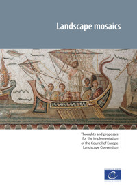
This publication presents thoughts and proposals for the implementation of the convention and addresses a "mosaic" of key issues related to its future. It forms part of a process of reflection on major themes concerning the living environment.
Sie lesen das E-Book in den Legimi-Apps auf:
Seitenzahl: 856
Veröffentlichungsjahr: 2022
Das E-Book (TTS) können Sie hören im Abo „Legimi Premium” in Legimi-Apps auf:
Ähnliche


Landscape mosaics
Thoughts and proposals
for the implementation
of the Council of Europe
Landscape Convention
Contents
Click here to see the whole table of contents, or go on the « Table of contents » option of your eReader.
Preface
The landscape reflects a present which interacts with a mosaic of memory traces which have diverse symbolic values.
Valerio Di Battista
The European Landscape Convention of the Council of Europe (ETS No. 176)1 aims to promote landscape protection, management and planning and to organise international co-operation. It applies to the entire territory of the parties and covers natural, rural, urban and peri-urban areas. It concerns landscapes that might be considered outstanding, but also everyday or degraded landscapes. The convention represents the first international treaty exclusively devoted to all the dimensions of landscape, considered from a perspective of sustainable development.
The Council of Europe is continuing the work undertaken, since the adoption of the convention in 2000, to examine and illustrate certain approaches to landscape.2 This book, entitled Landscape mosaics – Thoughts and proposals for the implementation of the European Landscape Convention of the Council of Europe, explores certain ways of understanding the landscape and makes proposals for more attention to be paid to it.
It brings together the reports presented by Council of Europe experts on the occasion of the Council of Europe conferences on the European Landscape Convention, organised at the Palais de l’Europe in Strasbourg, on 23-24 March 2017, 6-7 May 2019 and 26-27 May 2021. Representatives of governments and international organisations, both governmental and non-governmental, who took part in these meetings were able to discuss the subjects dealt with and make progress in the implementation of the convention.3
The experts who contributed to the production of this book are warmly thanked for the quality of their reflections and their proposals:
Valerio Di Battista –Towards a grammar of European landscapes;
Régis Ambroise – Designing agricultural landscapes for sustainable development;
Patrice Collignon –The rural landscape in transition: energy, agriculture and demography;
Mauro Agnoletti – Experience of Tuscany, Italy;
Carmine Nardone –The Manifesto for the beauty of rural landscapes in Campania, Italy;
Jean Noël Consalès – Urbanisation, town planning and landscape;
Felix Kienast, with F. Wartmann, A. Zaugg and M. Hunziker – A review of integrated approaches to landscape monitoring;
Barry Hynes, Valentin Riehm, Maguelonne Déjeant-Pons, with the contribution of Enrico Buergi – Experiences with public funds and the landscape;
Yves Luginbühl – Landscape and responsibility;
Michael Oldham – Professional recognition of landscape architects;
Claire Cornu – Dry stone walls in the landscape, inheritance and innovation for rural sustainability;
Gerhard Ermischer – Walking the landscape;
Klaus Fürst-Elmecker: Traditional forms of thought and spirituality;
Michael Oldham, with the contributions from Ana Luengo, Niek Hazendonk, Leor Lovinger, Indra Purs: Urban landscapes and climate change: the contribution of landscape architects to improving the quality of life;
Régis Ambroise: Landscape and the responsibility of stakeholders for sustainable and harmonious development.
Maguelonne Déjeant-Pons
Secretary of the European Landscape Convention, Head of Landscape, Environment and Major Hazards Division, Council of Europe
Sanja Ljeskovic Mitrovic
Deputy Minister of Sustainable Development and Tourism of Montenegro, Chair of the 10th Council of Europe Conference on the European Landscape Convention
Krisztina Kincses
Senior Governmental Councillor, Ministry of Agriculture of Hungary, Chair of the 11th Council of Europe Conference on the European Landscape Convention
1 Adopted by the Committee of Ministers of the Council of Europe in Strasbourg on 19 July 2000, the European Landscape Convention (https://www.coe.int/en/web/conventions/full-list/-/conventions/treaty/176 ETS No. 176) – now entitled “Council of Europe Landscape Convention” – was opened for signature by European states in Florence on 20 October 2000. A protocol amending the convention (https://www.coe.int/en/web/conventions/full-list?module=treaty-detail&treatynum=219 CETS No. 219), which entered into force on 1 July 2021, aims to promote European co-operation with non-European states wishing to implement the provisions of the Convention, by opening it to their accession.
2 Landscape and sustainable development – Challenges of the European Landscape Convention, Council of Europe Publishing, 2006; Landscape facets – Reflections and proposals for the implementation of the European Landscape Convention, Council of Europe Publishing, 2012; Landscape dimensions – Reflections and proposals for the implementation of the European Landscape Convention, 2017. www.coe.int/en/web/landscape/publications.
3 Conference reports: Documents CEP-CDPATEP (2017) 19; CEP-CDPATEP (2019) 20; CEP-CDPATEP (2021) 16. www.coe.int/en/web/landscape/conferences.
Chapter 1 Towards a grammar of European landscapes
ValerioDi Battista, expertto the Council of Europe
EmeritusProfessor of Architectural Technology, DeputyDean of the Faculty of Architecture and Societyof Milan Polytechnic and aNational Director of Research in Italy.
Introduction
A systemic vision
The state of the art in landscape studies, in academic research and in the field brings together a body of knowledge (literature, landscape programmes and projects) provided by many contributors and from such diverse approaches that they are sometimes both disparate and contradictory. This shows the need for methodological guidelines that are more in keeping with the concepts of the European Landscape Convention of the Council of Europe, and so closer to a systemic vision.
The convention recognises the essential role of landscape in the fundamental relationship that populations have with their living environment. It indicates that: “’Landscape means an area, as perceived by people, whose character is the result of the action and interaction of natural and/or human factors”. (Article 1.a)
Taking the landscape into account transcends the domain of “experts” and specialisation, and requires informed interpretation and decisions which should, as far as possible, be shared, in order to confirm the nature of landscape as an open collective work, continuous, rich in the symbolism and meaning necessary for existence.
It is in this context that this report was undertaken, in order to begin to systematise some methodological references (mainly focused on theory) and, from there, to identify methodological guidelines (focused on implementation). The general concepts stated should be applicable to different cultural settings and operational contexts.
In the logic of a close interaction between knowledge and decisions, the analysis and project phases complement each other throughout any planned intervention. It is a question of developing collaborative and interactive approaches between public authorities, professionals and the public, in order to promote actions and achievements in favour of the landscape. It is about facilitating open, continuous and interactive processes that give better perspectives and conditions conducive to self-organisation.
The symbolic value of the landscape
Nowadays, the landscape, as a symbolic form, can assume the role that perspective played for people of the Renaissance (Panofsky 1927). According to Guido Neri, in Panofsky’s view:
two essentially different conceptions have arisen. ... One which corresponds to the disjointed, contradictory, “finite” objectivism of the ancient world, and one which corresponds to the homogeneous and “infinite” modern subjectivism... and this will accompany us right to the start of this century. (Neri 1961)
Just as perspective became at the time a symbolic form in that it expressed a certain concept of the world, the landscape now conveys an open, complex concept, discontinuous in its signs and meanings, and also unstable, but continuous in time. The landscape is coming to represent a relative “reality” that matches certain cognitive interactions with advances in knowledge and the language of contemporary art. It is now taking on a very relevant cultural and operational role. Referring to people’s perceptions permits the emergence of a new balance of uses, decisions and actions involving the landscape, while opening up further prospects, some of which may be difficult to accept.
It is possible to identify contradictions and discrepancies between the various approaches, as well as between these approaches and the everyday operational practices applied in landscapes. This is the result of a culture of separation – cf. the Cartesian paradigm (distinction between res cogitans and res extensa) critically examined in Morin 1999 – and our dual role as landscape beneficiaries and operators. The human being is thus the bearer of concepts, opinions and actions which always have an impact on the landscape. That impact is an unintentional outcome of the cumulative actions and interactions of random processes, which often dissipate energy, coherence and other material and immaterial resources. There are also coherent elements that explain the positive values of many spontaneous, human-made landscapes and of processes from which forms of self-organisation have emerged (Gutkind 1958).
These preliminary remarks, together with the landscape’s correspondence to the “place-based identities” of environmental psychology (Bonnes and Secchiaroli 2005), suggest that greater attention should be paid to the different types of unintentional processes.
1. Methodological references
Experiencing the landscape
The concept of landscape as perceived by people implies taking into account all the cognitive references that have the notions of “territory” and “environment”, supplementing them with symbolic values which those references do not possess (Changeux 2012).
Who observes what?
The public – individuals and social groups, with their narratives and representations, as well as scientific bodies and institutions – are all systems engaged in observation, systems which describe and use landscapes and take decisions and actions affecting them. They have different levels of expertise and awareness. Some steer and manage intentional processes and projects. All are users of the landscape and are sometimes involuntary actors.
What do we observe?
The landscape is the system of signs and meanings which surrounds us. Sensory enjoyment of the landscape is total. In other words, what we see is accompanied by noises, sounds, scents or odours, in a multiscalar dimension. The term “multiscalar” is understood to mean the perceptual coexistence of signs that are very close and/or fairly close, along with signs that are fairly distant and/or very distant. This is the single image that the human being constructs from all the visions and representations available (in computerised mapping, it is possible to use zoom effects or a vision from different points). The human being is always and only surrounded by landscapes.
How do we observe?
Landscapes can only be observed by moving through a territory. The landscapes of a territory can only be observed by travelling through it. Aerial, satellite or map views, describing positions and distances that are not identifiable by direct observation, are necessary operational descriptions, but they are not the same as the beneficiaries’ perception, because they never manage to recapture the emotive and cognitive impact of direct perception.
Territories and the environment are analysed using a variety of methods from many scientific disciplines – environmental, anthropological and economic – through different approaches (perceptive-visual, psychological, social, historical and cultural and descriptives). These are mostly associated with pictorial, photographic and literary representations. All of them provide valuable knowledge, but because they are partial and disparate, they struggle to capture the entirety of a system. As this scheme of isolatable units acting in a one-way causality has proved insufficient in modern science, notions of wholeness, holistic, organisational, or Gestalt, have expressed the need to think in terms of systems of mutually interacting elements (Bertalanffy 1968; see also Farina 2006).
Visibility and visual perception
Visibility is about the sight as observed, free from all meaning and value. Its evaluation across a territory is essential to identify the various visual weaknesses (areas visible or not visible from given points). It can be carried out by an analysis or interpretation: indirect (visibility is assessed by means of cartographic bases, and different types of representations, such as photos or videos); direct (it is carried out in the field by experts along with representatives of the population); passive (it takes into account the ways and probabilities of being observed).
Beyond visibility
Recognition
Recognition is essential for a complex perception. It allows a person to identify and assign value (a name and meaning) to the various landscapes. Recognition involves sensations and memory, activates cognitive functions and organises complex judgments based on delimitation of the observation area.
Delimitation
The primary function of visual information, for humans as well as for animals, is to allow the recognition and delimitation of a territory for survival purposes (food, security, well-being). Nowadays, for human beings, delimiting boundaries involves recognising the context of social, emotive and identity-related interactions.
A context is defined with particular physical characteristics in which the participants are engaged in particular activities, in particular roles for a particular period of time. The factors of place, time, physical characteristics, activities, participants and role are elements of the context. (Bronfenbrenner, 1979)
Documentation
The visual perception of a territory is not complete without taking into account the extensive information and descriptive or interpretative framework generally available. Every place is a cultural repository of information which it can be useful to collect and organise (cartographic and other documentation from museums, ecomuseums and other sources). The documentation can be informative, descriptive or interpretative.
Most of the time, informative or descriptive documents already exist. However, they are sometimes difficult to identify or are not always known. They can also be discontinuous, in time or with regard to the arguments presented. However, they are still useful and can be updated.
Interpretative documentation includes historical and literary texts, pictorial, photographic and filmed representations and much else. Narrative and iconography, including modern interpretations, offer important historical and geographic points of comparison.
Identification
What is visible or invisible helps identify places and brings to mind the Gestalt laws. Occurrences, quantities, physical characteristics (features, geometry, dimensions, materials, colours) and their disposition give the system its name and its primary meaning (for example an agricultural, urban, marine, mountain or river landscape). If we consider a landscape containing a plain, a river and a hilltop bastion, the observer is assumed to be on the plain or on the hill, depending on the point from which the observation is made (law of proximity). However, if, for example, the observer is on a plain within a wide valley among mountains, the landscape will be identified as a mountain landscape (law of good Gestalt). Similarly, the landscape will only be defined as fluvial if a river can be seen or if the observer has a memory of being next to it, even without seeing it (law of past experience). In an indirect view the same landscapes lose these denotations.
The visual, temporal and associative characteristics of a landscape represent structuring factors that make it possible to identify a landscape by organising the many variables that compose it (Norberg-Schulz 1979; Lynch 1960). They determine its dominant components by giving it specificity.
Visual characteristics derive from signs: shapes, figures, volumes, surfaces (flat, inclined, concave, convex), textures (thick, thin), profiles, lines, points which configure the elements (soil, water, trees, clouds, constructions, roads, buildings) under observation conditions (directions, light, shadows) and in terms of distance, horizon, boundaries, position, dimensions, materials or colours.
Temporal characteristics derive from the observation periods (duration, frequency, cyclical nature of use, dynamic perceptions, seasonal conditions, diurnal cycle), and also from the accumulated visual and cultural memory. The latter is determined not only by the various lifetimes within the systems being observed, but also by the different identifications made by observers. Therefore, the landscape reflects a present which interacts with a mosaic of memory traces which have various symbolic values.
Associative characteristics are observed by associations of images (views that resemble each other may be perceived as having similar meanings) or situations (views may take on meaning or vary depending on the situation or particular events experienced or remembered: synchronic, diachronic, mnemonic).
Intervisibility
In any landscape, the human being sees spaces (open, closed or otherwise) as well as many other things. Their combinations change with the visual observation conditions (positions, movement type, seasonal variations, brightness), interacting with the other senses, with memory (emotions and knowledge) and with different intentions and information.
Because of the importance of visual experiences, any landscape analysis must consider the issue of intervisibility, direct and indirect. It is necessary to carry out cartographies of views, from and in different places. The resulting processing of information must take into account the direct perception, the most common, that each person has of their landscape and their place in life. It is important not to limit the appreciation of the landscape to only remarkable elements and not to put obstacles between knowledge and experience, between use and regulation.
Indirect intervisibility methods should be applied, while integrating them with local direct intervisibility perceptions.
Interpretation of the conditions of intervisibility of a territory makes it possible to adjust the observation in relation to what one wants to look at and to improve the perception of the system operating through different views and fields of vision with accentuations, corrections and reductions in various visibility conditions.
The analysis of intervisibility (indirect and direct) is a working basis necessary for many operations (identification of the landscape sensitivities of a territory; selection of panoramic views with different degrees of suitability; selection of fields of active and passive vision, as the basis for the functioning of the landscape; enhancement of landscapes, natural, rural or urban, with the creation of paths and stopping points).
By working mainly on the issue of perception, these different options make it possible to design a landscape project without the landscape as such being transformed, and to improve it by making better use of its specific characteristics.
Complex perception
Assessment
Every landscape offers a host of primary stimuli required for survival (usability, safety) – “It is about understanding these ambivalent relations which are woven between the elements of the landscape and the body” (Galimberti 2010) – and gives information to help recognise places, “things” and ourselves.
“Place” refers… to the essential nature of the location differentiating it from all other locations. “Place”... is the way in which landscape dimensions combine together and are identified to produce a distinct environment and a particular sense of location. (Canter 1984)
As observation systems, we gather, select, process, memorise and compare stimuli and visual information which we use to control instinctive reactions, activate emotions and “feelings” and accumulate knowledge (Peirce 1980). Mallgrave says of emotions that by most definitions, they precede our conscious awareness of feelings, and initially code whether an environment is pleasing or not (Mallgrave 2013).
Interpretation of the interactions between positions (near/far, below/above), dominant configurations (mountain landscape, urban landscape) and prevalent characteristics (wooded hills, dense construction, cultivated open plains) allows recognition (known/unknown) and identification, and generates first impressions and assessments (harmonious or inharmonious landscape, coherent or incoherent landscape; approval, indifference or disapproval; safety or danger; well-being or discomfort, etc.) of a landscape.
In the landscape these forms of recognition and assessments always relate to numerous observers with different degrees of expertise. Individuals develop different levels of appreciation and well-being. Professionals (analysts, decision makers, operators) target their assessments to confirm or modify their intentions and, therefore, consciously choose their descriptive terminology. Professionals and local inhabitants (often the same people) constantly interfere in each other’s assessments but can come together with difficulty. The expert perceives the landscape (abiotic, biotic and human systems and subsystems) using scientific methods which “colour” the landscape based on their own content and terms. However, there are also multidisciplinary contributions dealing with the specific problems of each territory that use a mutually agreed language resulting from comparison of the assessments.
These unconscious and conscious denotations, which vary in their degree of intent, include processes for conserving or transforming the landscape with internal, disparate and variable consistencies or inconsistencies.
Assigning values depends on many individual variables (such as knowledge, motivations, physical and psychological conditions) and social variables (cultural models, customs, shared appreciations).
The most common values attributed to the landscape are aesthetic: approval and acceptance (beautiful, pleasant); indifference (mundane, insignificant); disapproval and rejection (ugly, unpleasant).
In fact, there are more mixed values involved. Subjective (affective, emotive) and social values (naturalist, religious, linked to material and immaterial culture) reflect the local consensus and prevalent cultural models and together form the complex perception of a place (Donadieu and Périgord 2007).
Public perception
An initial approach to involving the public envisages “a joint effort among academics in the fields of natural and human sciences, planners, administrators and local populations; an effort to provide education and training, linked to field projects” (MAB 1988; Bonnes and Secchiaroli 2005). The perception of a landscape is a cognitive process and encapsulates recognition, identification and assessment (Bateson 1979; Maturana and Varela 1980; Varela and Shear 1999; Neisser 2014). It occurs in different ways and at different levels of interaction between “knowledgeable” and social observations, and between expert and emotional perceptions (CM 2008: II.2.1; Changeux 2012). In every case, it provides interpretative analysis which is essential for exploiting the landscape’s signs and meanings.
Every landscape supplies a vast amount of information, the selection and deciphering of which depend on what we want to know, on what we already know and on the levels of emotive involvement.
Many actors (of various ages, activities and interests), as well as many structures (political, administrative, scientific), with diverse, varied and possibly conflicting experiences, skills and interests, carry out targeted observations, depending on their specific motivations.
Often, each of these observations has the effect of limiting the emotive relations and experiences which generate cognitive processes, but taken together, they offer a composite, albeit frequently specific, perception. The path that goes from “elementary” perception, to “complex”, and then “interactive” perception, translates in a simplified but real way the scientific debate between cognitive and neurological sciences. “Through the landscape, there is this exchange between man and the environment through which man adapts (psychological and mental) to his own world.” (Turri 1974).
All individuals, as landscape beneficiaries, describe global perceptions (sensorial, psychological, emotive, pleasurable, beneficial, economic, etc.) and always mention, individually or as a community, their living environments. The social perception deriving from the various local observations and experiences is therefore always composite, uncertain and fluctuating. It is based on different recognitions of the visual perception, while being influenced by the expert identifications, and tending towards general assessments which are often imprecise and sometimes biased. However, the analysis of this perception is necessary since it is the starting point for actions that produce and change landscapes.
Public and experts
Everyone is both a user of and actor in the landscape (CM 2008: II.2.1). Each of us manages the areas and aspects of the landscape in which we live. We look after and/or modify “our” private space (by choosing colours, objects, layouts) and interact with public areas (by planting flowers, but also by dumping rubbish).
When they are observing, users of and actors in the landscape have the impression that other users and actors offer sectoral or insufficient descriptions of the landscape. This feeling can arouse mistrust, leading to dismissal of the recognition of the concept of landscape as an important common good. Differences in perception, motivation and language can cause misunderstandings between the public, experts and institutions.
Utility use
Utility use is always one of the reasons for interaction between the public and living areas (environments, territories, landscapes) and often assumes symbolic values (Magnaghi 1998). Factor variations, in place and time, interact with all the characteristics of the landscape and have quantitative and qualitative implications with positive and/or negative symbolic values of the landscape.
Utilitarian and symbolic enjoyment is always present and derives from individual and social motives (activities, interests, opportunities, demonstrations of belonging, wealth, power, etc.). They vary in their causes and levels of intensity; they are random, or they build up and generate habits (inertia), become local customs (not always positive), highlight links and offer degrees of freedom. They produce positive encounters (shared experiences) and negative ones (rejections), social relationships conducive to co-operation, but also to conflict.
The person as a social agent seeks and creates meaning in the environment… a second important process issue involves the understanding of interrelationships between the environment on the one hand and group formation and maintenance on the other. (Saegert and Winkel 1990)
Coherence between interactions
Within landscapes we can perceive signs and information elements with coherent meaning (generally comprehensible and well-accepted) or incoherent meaning (difficult to grasp and with a low level of acceptance).
The difficulties in achieving coherence between the intentions of the various actors, the discrepancies between expert interpretations and practical perceptions, between utilitarian values and symbolic or emotive ones associated with living areas, generate, involuntarily, unintentional processes.
The perception (and the very concept) of a landscape accordingly fluctuates with the instability of interactions between systems that lack consistency. But this very state of instability could generate self-organisation.
Conditions and levels of incoherence – the presence of signs with configurations or materials which are incompatible with the context – can trouble perception (visual and descriptive). Visual incoherence results from signs and meanings which diminish or distort the system’s values, as happens, for instance, with an element which is “out of tune” in a piece of music or a literary work.
Intentional and unintentional processes
Within landscapes, various analysis, decisions or operational processes occur, which are intentional, partially regulated ( “implicit” effects) or unintentional (spontaneous, diverse and disparate). Intentional projects are projects (run by institutions or operators) which are supported by planning, scheduling and design techniques with effective and efficient cause– effect relations. In partially regulated processes, the rules and programmes do not generate sure and certain relationships but allow probabilities or implicit effects (Dematteis 2007). Unintentional projects are heavily emotion-orientated and have uncertain cause-effect relations. Social psychology defines “spontaneous” processes as those which occur: “without any cognitive effort and without careful reflection; attitudes are automatically triggered and have a direct influence on behaviour. The more accessible the attitudes, the more foreseeable the spontaneous behaviour.” (Boca et al. 2010).
All these processes interact with each other in space and time, engendering a tangle of indeterminate, unpredictable and only partially controllable relationships – in other words, an essentially unintentional process. This can cause difficulties and require the development of new concepts, new levels of interpretation and ways of organising actions, which in turn have an impact on the project concept.
Intentional processes can also, in general, cause unintentional events. This means that it is very restrictive to apply to the landscape the logic and procedures of an intentional project. No intentional project can withstand the power of an unintentional process which has a continuous effect on the landscape. Contemporary landscapes created by humans seem largely to originate from global unintentional processes, guided by cultural models (products, available techniques, customs and tastes) which are becoming increasingly homogeneous and standardised.
Unintentional processes easily cause negative effects: banalisation, noise, waste, neglect. They also reflect the cultural rejection and the limits of dissipative models. However, in some cases, strong interaction between the community and the natural characteristics of places has given rise to unintentional landscapes with significant coherence between architectural elements and the landscape (Rudofsky 1964).
It is therefore still possible to envision that those processes that develop in a more conscious way can improve conceptions and behaviours in the relationship between man and territory, the environment and the landscape.
The landscape project
Issues
The landscape always shows an accumulation of projects. Some of them are intentional, run by technical specialists (infrastructure, constructions), often having an impact on the surrounding landscape and always on the near landscape, and producing, as a whole, unintentional outcomes.
Many projects follow the cultural trend of “novelty”, which very often underestimates the importance of a good knowledge of the physical and denotative interactions still present in every place. However, insufficient consideration of the history of places more often generates attitudes of indifference, or even errors at the local level.
How have we managed to reach the point of condemning the theory and practice of construction as the symbols of everything we believe as being the most destructive... of being the worst ugliness, sordid venality... huge projects which destroy the life of the common man, organised malice which is not mitigated by a single social value? (Blake 1978)
It is therefore necessary to adopt a project approach that draws on the legacy culture (Battista 2006).
This approach comprises analyses – ranging from perceptual analyses to identification, assessment and ultimately to operational diagnoses – and strategies for planning interventions and selecting more suitable operational practices.
Standardised landscapes
Nowadays, many landscapes reflect a pervasive form of downgrading through standardisation, which occurs on two parallel levels: the neglect of existing landscapes and the arrogant unoriginality of new landscapes. Existing landscapes (natural or anthropised) embody identity-related values, which are weakened when the forms of use and appreciation that prevail result from new types of consumption (such as mass tourism). The new is often accepted as such, even if it is aggressive in a particular context.
Urban landscapes are becoming increasingly similar throughout the world, and it is significant that this affects areas with a potentially high real-estate value as much as shanty towns. Too often, only preexisting areas still have distinctive features; however, everywhere fairly similar transformations are taking place.
Rural landscapes are marked by the invasive presence of single-crop farming, new production facilities (warehouses), energy systems and dwellings (housing and small apartment blocks).
Participation
The presence of unintentional processes in the landscape requires public participation, which today takes place mainly during the analytical phases, but is seldom present in the decision-making process. This shows the prevalence of top-down models, which seem surmountable only on a small scale, for instance in a village or a neighbourhood where it is easier to initiate shared analysis of the existing landscape and involve users in operational decisions and processes.
Even in these cases, participation requires the people’s faculties to be as receptive as possible, and a broadening of the appreciation, which in addition to visual, emotive and symbolic appreciation embraces all the other values (ownership, use, availability, efficiency, performance, economics, social relations). This enlargement of appreciation encompasses decisions which are the preserve of those with political and technical mandates and alters the culture of the project.
Methods
Legacy culture
Under the legacy culture, we are all responsible and we are all actors and operators in relation to our surroundings (houses, roads, districts, villages and territories). In relation to the landscape, the legacy culture (in terms of both analysis and assessment) requires expert knowledge and the people’s perception:
Participation implies two-way communication from experts and scientists to the population and vice versa. The population possesses empirical knowledge (local and naturalistic knowledge) that may be useful in completing and contextualising specialist knowledge. (CM 2008: II.2.3. A)
The analyses provide the structure for assessments which define objectives. This (analytical/decisionmaking) process occurs via means which are intentional (informed and expert) and unintentional (spontaneous, little informed), and these co-exist but do not collaborate.
Any project must therefore be based on the existing situation and consider that each action undertaken affects and produces the landscape (Morris 1881). The evaluation of projects must constantly guide the projection of what will be, the vision of the future. The project organises a process (intention, preparation of actions, activation, control of the outcomes and any feedback) which provides a specific context for relationships of cause and effect. This concept enables better outcomes to be achieved based on few variables and simple aims. In the case of complex elements, the project organises separate processes. This procedure, when applied to cities, territories and landscapes, proves to be inadequate as a means of regulating indeterminate processes and achieving the desired results (Dematteis 2007).
Legacy projects
This concept makes it possible to draw inspiration from certain established procedures in the field of architecture (ANCSA 1986), to consider the following elements in a landscape context:
knowledge and evaluation of the conditions of use (diagnosis);
taking into account the diversity of the people, their roles and the necessities;
complexity of the processes (interactions, durations, instability);
complexity of the choices to be made between conservation and processing, identity and utility;
iterative procedures involved in diagnosis and decision making;
the requirement for pragmatic, participatory, open and continuous guidelines.
In the landscape, as with the built environment, ongoing, pervasive processes become prominent, processes which reflect social organisations, methods of production and cultural developments, and which also interact with abiotic and biotic systems. Landscape management unifies the range of political and cultural options on the ground and necessitates operational methods compatible with the long-, medium- and short-term variables present in settlement systems.
Interactive perception and unintentional projects
The landscape involves all the environmental conditions (climate, soil, water) and all living organisms (from bacteria to human beings) and brings to the fore, on different scales, interactive perceptions and projects (intentional and unintentional) which function with different purposes, modes and time frames.
In this dense network of processes, the intentional objectives cannot merely give rise to ad hoc instructions and verifications; the aim must be to create a diffuse culture (material and immaterial) of skills and sensitivities for guiding improvement processes. This requires gradual self-adjustment (as in politics and the programmes of large business groups) in order to identify strategies and run projects.
Landscape strategies
The term “strategy” is used to designate a process which influences the interactions between all the individuals in their relationships (utilitarian and symbolic) with the various places (landscapes, environments and territories). Landscape strategies require autopoietic approaches, namely practices which are flexible and adaptable to perceptions of the values and critical issues at stake in the operational context, with a view to self-adjustment and integration of intentional projects, mitigation of the adverse effects of unintentional factors and the triggering of improvement processes.
To a first approximation, these are networks of management processes (signs, meanings and uses) which, by interacting with each other, reorganise and characterise the system (Donato 2010).
These are difficult processes, but they are simple to initiate based on the human resources most concerned (almost always present in every community) and the most feasible improvement and/or enhancement objectives. It is advisable to proceed in stages, involving both the population and the experts.
Awareness raising
Interpretations of intervisibility (expert exploration of visual perceptions) highlight indisputable values (such as sensitive and hidden areas, symbolic places and goods) that can trigger perceptions among people that gradually become more complex and interactive.
Article 6. B (Specific measures) of the European Landscape Convention recommends approaches which create a kind of complicity with the landscape, such as awareness raising in schools, museums and ecomuseums (see also CM 2014).
Assessment
To identify values and clarify strengths and weaknesses in an open and participatory manner, the following methods can be used: SWOT (strengths, weaknesses, opportunities and threats) analyses, focus groups, surveys, interviews and “parish maps” (a concept from anglophone experiences of culture mapping in the 1980s). It is also possible to carry out post-occupation evaluations (POE); similar procedures can be applied by questioning users about situations in the areas they use, to verify and rectify technical weaknesses.
Devising strategies
The above analyses identify areas requiring more in-depth examination and suggest priorities and alternatives for maintaining strengths and positive values and reducing weaknesses and negative values. Multicriteria participatory assessment of such options can enable joint strategies.
Implementation policies
It is for the public authorities in their administrative area to devise framework regulations, select quality objectives and adopt (joint) strategies to be converted into short-, medium- and long-term implementation policies (CM 2008: II.2.2). At the same time, they should facilitate and initiate forms of public participation. This will produce direct effects (in reassessments, reuse of public goods) and implicit effects (brought about by rules), which can be combined with the unintentional processes arising from local needs and the existing culture.
Monitoring
Over time, institutions at every level can monitor positive and negative outcomes, update objectives and adjust intentional actions (programmes, plans and projects). It is important to know that every decision or action can preserve or modify, improve or degrade the signs and meanings of the landscape.
Transparent and ongoing plan and project
The methods already tried and tested for the built environment result in rigorous iterative diagnosis and decision-making programmes which explain where and what to preserve and/or transform, and how to identify the various types of intervention to achieve results which are compatible with the objectives (Di Battista 2006). Regarding programming, refer for example to Italian standard UNI 10914/21 and about projects, refer to standards UNI 11150 (1-2-3-4) and 11151. In the various landscape systems (macro, meso, micro), each of the actors (at their level of influence) determines eventualities based on assessments of the status quo; comparison of the various assessments generates decisions which require mediation. If the assessment is satisfactory, it will tend to favour conservation and, if unsatisfactory, it will tend to favour transformation.
Decisions made about the existing heritage will generate processes with various levels of motivation and awareness (intentional and unintentional) and will interact with the abiotic and biotic systems, even when partly controlled by environmental impact assessments or strategic environmental assessments. Within a landscape these processes reflect identities, alongside the state of the living environment. In this respect, the landscape provides a unique opportunity to adopt an integrated approach to interpreting and governing the material and immaterial interactions of settlement systems.
Enhancement of the quality and roles of the stakeholders
It is wise to promote quality improvements in the operations and roles of:
institutions with political or technical responsibilities (expert analysis phases, simulations and monitoring);
users/operators with social responsibility for interpreting values and requirements (social, economic, cultural, psychological) and in possible forms of grass-roots self-organisation.
Developing a co-evolving dialectic
The development of a co-evolving dialectic of stakeholders would make it possible to bring together various policies related to habitat (landscape, environmental and territorial) and landscape; and promote an open, ongoing project with the aims of:
interpreting diagnoses, positive or negative (operational diagnoses are regulated by the strategy, but allow feedback);
simulating choices and advising on alternative assumptions;
regulating the life cycles (continuity and/or change) of the signs and meanings present in the landscape.
If simulation is needed, current rendering software makes it possible to present environments, even complex townscapes, from different viewpoints at various levels of detail, and to simulate explorations by moving within the model.
Initially, an open and continuous project can be tedious and slow to complete. However, this is accompanied by a large number of positive effects in terms of awareness and training, which are less visible but essential. They can indeed contribute to enhancing the quality of cultural models, the techniques used and “tastes”. It is useful to define methodological guidelines for improving unintentional processes that have effects on the landscape and the living environment. Assessing the likelihood of sustainability offers numerous opportunities for regulating and choosing among the various types of intervention.
2. Methodological guidelines
Methodological guidelines can be consulted for any type of landscape, at any scale and with different modes of participation. The guidelines presented below are open indicators that can be used together or separately, irregularly or periodically. It is suggested to use only those approaches that have a strong likelihood of success; there is no need to waste time with unusable results. The results achieved may then require more in-depth analyses. They can be adapted to the specific situation of each state or territory, considering the applicable legal framework.
Awareness raising among civil society, private organisations and public authorities is a prerequisite for increasing the attention paid to and interest in landscape issues. The landscape is a resource and an opportunity.
Taking care of the landscape should, as called for by the European Landscape Convention, permeate training and education processes. Specialisation and refresher courses using appropriate teaching methods for technical staff and professionals of public authorities can thus prove useful.
Public participation is a complex process which is different every time and relates to a delimited area.
It implies recognition of the rights and responsibilities of populations to play an active role in the processes of acquiring knowledge, taking decisions and managing the quality of the places where they live. (CM 2008: I.2)
In small villages, where active associations co-operate with the authorities, the possibilities to participate in the whole process are greater but depend to a large extent on the availability of the necessary capacities. In medium and large centres, organisations representing beneficial interests and better organised associations seem to predominate.
The presence of local observers and the support provided by university research and pedagogic activities in the field have an important role here. Participation can be strengthened by involving the population in data collection, project development and landscape management. Participation in analysing and assessing the maps and subsequent strategies may focus (intentional) policies through better informed management, launch actions, improve (unintentional) behaviours and allow continuous interpretation of the processes under way. Landscape observatories, centres or institutes, as well as specialists and professionals, can support this work.
Landscape analysis
Visual perception
To define what is seen in a landscape, it is necessary to carry out visibility analyses to understand how the landscape is perceived, and then to make assessments. These are indirect, when they are made from representations of the landscape, or direct, when they are made in the field.
Indirect analyses of visibility
Indirect analyses of visibility are made from graphics, photographs and other representations, in association with analyses of indirect intervisibility. This form of analysis selects observation points and identifies what can be seen from these points (the “viewshed”), considering altitudes and landforms. Similarly, a digital terrain model (DTM) can be used to calculate lines of sight by means of algorithms. In both cases, the viewshed is defined from the point being considered.
Theoretical intervisibility (excluding probable obstacles) makes it possible to measure the likelihood of the various parts of the land being seen when a territory is traversed. The Natural Breaks method allows the researcher to obtain normalised values between 0 and 1 and to classify them into five intervals. This involves measuring the differences in theoretical visual sensitivity for the land’s different viewsheds. On a large scale these techniques make it possible to establish a basis for raising individuals’ awareness and identifying landscape areas, or territorial units (in terms of character, identity, etc.), and promoting management strategies.
Direct visibility analysis
This involves identifying places, paths and points with various landscape qualities, then describing the landscapes visible from the fields of view and viewsheds.
Field of view. The field of view defines what is in front of a person, to the right and to the left, up and down, in respect of a directrix (optical cone). In the vertical and horizontal planes, an optical cone has a generatrix at an angle of 30o to the main straight line directrix. It allows you to estimate distances, positions and conditions of movement. It is unidirectional and selects the views of interest from every point. The field of view of a landscape from every point can be used to determine different levels of visual enjoyment, using such parameters as: expanse, which indicates the entire distance the view extends across the horizon (possibly measured in degrees); and depth, which is the distance from the most distant profile (in defined conditions of clarity and possibly measured in miles or kilometres, verified by mapping).
Viewsheds are areas delimited by points with two-way intervisibility. They are useful for verifying visibilities (i.e., the different probabilities of an area being observed). However, landscapes are not qualitatively similar. For this reason, in direct intervisibility it is useful to distinguish between active and passive visibility. The brain, in its sensorial processing and image making, operates through a process of pattern recognition, for which metaphors seem to be an ordering principle (Edelman 2007). Up/down, front/ back, static/movement, all are metaphoric or existential categories emanating from the body and through which we read the events of the world (Mallgrave 2013).
Active visibility
The active view creates interaction with elements of the landscape and with the landscape as a whole. A view can be experienced directly by individuals with differing levels of expertise. In organising observations, the following data should be noted: the area concerned (which may correspond to a landscape unit, or not); transport (by car, on foot); means of recording (photo, audio, video, notes, drawings); identification points on a map showing the path followed and observation points; identity of the observer; direction of fields of view, characteristics of and problems with the landscapes at different distances; various notes (e.g. season and time of observation, light conditions, clarity). If observation is being carried out by several individuals, the composition of the sample should be specified. Notes can be used to record other relevant conditions (sounds, odours), which may be positive or negative, permanent or occasional. Observations always require pictorial documents (photos, videos) and can be supported by measurements (breadth and depth), maps (paper or digital) and relevant symbols, as well as by specific protocols, if comparisons and follow-up are to be made.
Multiscalarity is an “active view”, which places people in a space defined by different dimensions, each contained inside another. Such a view can give access to landscapes of varying extents and can focus on sections of space placed in different positions and with varying characteristics.
Background landscapes are determined by the last visible profile, which may coincide with the successive limits but may also, with high mountain systems and good visibility, be beyond 150 km distant.
Wide-area landscapes have very distant horizons (between 5 and 15 km away) and include extended territories which sometimes have heterogeneous characteristics. The public can recognise them as identity related. The boundaries of a landscape differ depending on whether it is perceived in terms of visibility or as an identity-related area.
Contextual landscapes allow visual recognition of the signs present, which diminishes with distance. A distinction should be made between near (0 to 1.2 km away), intermediate (1.2 to 2.5 km) and distant (2.5 to 5 km) landscapes. “Near” includes landscapes within touching distance (within a few metres, where the concept of proxemics is relevant)1 and those a short distance away, which offer the best analysis of details (up to 0.5 km). These distances influence the perception of all the above landscapes. In each type, the differing distances lead the observer to mark positions and distinguish signs using different definitions, features and visual characteristics.
Visual perception, passive view. A passive view corresponds to the way a place appears when observed from the outside. Every system of signs can be seen (with different probabilities) only from certain positions. It will not be visible from others, as if it did not exist (thus, more attention is given to street fronts than to inner courtyards). A passive view makes it possible to identify passive sensitivities. For example, a historic village may have street fronts which are particularly visible (and therefore need to be looked after with particular care and attention), or conversely a territory can include areas which are barely visible (where objects with a negative visual impact can be concentrated).
Visual sensitivity
Greater visual sensitivity is associated with places that are easier to observe and more likely to be observed. This means that some places may be visible from more paths, for longer periods and by more people.
Intervisibility
When analysing the landscape, it is necessary to consider interactions between the observed system (distance, recognisability of configurations and profiles) and the observers (positions, means, probability). As a result of this analysis, a first map (networks or sequences of points and paths) can be produced, with areas of varying visual sensitivity, making it possible to verify with other individuals whether the visible elements indicated are significant in terms of the character and identity of the relevant territory. This initial exploration (during this phase indirect expert observations can be used) discovers and denotes the territory and constitutes an indispensable foundation for getting administrations and the public to focus attention, even if very slowly at first, on their own landscape and on establishing conservation or transformation programmes.
Complex perception
Recognition
Orientational recognition processes information about the observer’s position and movement. It involves limbic functions which trigger instinctive reactions and emotive assessments, and activate the senses of safety or fear, well-being and pleasure, or discomfort. It can derive from the roles of key landmarks and dominant elements and be modified by distances. We can distinguish three kinds of recognition:
Primary unintentional and involuntary recognition allows comparison of emotional interactions with the landscape.
Comparative recognition compares systems of signs; it is both voluntary and involuntary, and may depend on the reasons for observation, on memory and on existing cultural models.
Intentional recognition is voluntary and conscious. It generally uses highly structured cultural models (scientific, philosophical, religious, etc.) and functions through selective observations geared towards gleaning specific knowledge.
Visual delimitation
Visual delimitation allows to delimit areas with active views (fields of view and viewsheds). Areas under observation often do not have clear-cut boundaries; they may change as the observer changes position. Boundary delineation may be open or closed, depending on the types of movement involved, such as linear or circular. The border lines can overlap and be permeable (areas whose attributes are structured by links with neighbouring territories). Some links can be perceived from a social point of view but not visually.
Information material
Every landscape unit, however defined (it may, for convenience, coincide with an administrative area), relates to a huge quantity of information, much of which is scarcely known or used. Each landscape study requires general information (geography, history, anthropology) and specific information (pedagogical, typological, repositories of local culture: thematic collections, finds, documents, targeted interviews).
It is advisable to consult the urban planning documents (general and sector-specific), studies and reports (including grey literature produced by institutions, research centres, universities), statistics, basic and thematic maps, archives, descriptions, literature and other available sources. It is useful to have a cartographic database (maps, historical property registers, surveys) and a bibliographical database (history, climate, geology) including titles and sources of general and specific findings concerning the observation area, and to have a historical and current picture repository for paintings, drawings, photographs, videos and film clips.
The task of collecting and organising the material can be carried out at local community level with the help of local libraries, schools and other groups, and help with training among stakeholders and awareness raising on the characteristics and issues of the territory (CM 2014).
Identification, qualitative sensitivity
The “character” of a landscape derives from dominant elements, key landmarks and the physical presence of the elements which identify it. Characteristics may be visual and temporal.
Visual characteristics
Every view provides a whole host of information (Lynch 1960; Cullen 1961; Bishop and Lange 2005; Gombrich 1985; Fiorani 1998; Arnheim 1954): positions (front, side, above, below, alignments), dimensions (large, small), distances (near, far), signs (shapes, figures, masses, volumes, areas, profiles, lines, points), elements and materials (soils: rock, earth, sand, gravel; water: still, slow- and rapid-moving, steam, ice; trees, bushes, meadows; roads, buildings, paths, facilities; everything with textures, grains, surface colours), light conditions (direction, intensity, reflections).
The direct visual perception of the landscape depends on the openings or obstructions (compact or semitransparent) which structure the landscape, giving access or not to certain views from a given point or along a path. This perception makes it possible to synthesise information about the landscape and to analyse it, highlighting areas of different sensitivity.
The first and best-known system of interpretation is that proposed by Lynch (1960), who in the case of large-scale urban landscapes distinguishes paths, edges, districts, nodes and landmarks. One might add the following considerations.
Paths are places where the observer moves around (regularly, occasionally, potentially). They are streets, walkways, canals, railways or other routes. People observe the landscape while moving within it. The landscape’s elements are arranged and linked along the paths.
Edges are linear elements which define boundaries: shores, railway embankments, walls, ridges, etc. They separate different physical components (water, land) or form vertical closures (constructed or green) along a route.
Districts (and contextual landscapes) are areas which the observer moves within, enters or leaves. They are recognisable from a few easily identified characteristics (dominant and prevalent elements). Urban areas are mainly identifiable from the inside.
Nodes are focal points, which observers move towards or away from. They are accessible, strategic points of a city or territory. They may be points where paths from different contexts or districts cross or converge. They are also concentrations of activity, places of denser use or high-profile places (open or constructed elements), playing a dominant role.
Key landmarks are defined as external, high-profile point references. They are dominant, guiding components, visual stimuli at various distances, which provide basic information for establishing position and direction of movement. Since they permit adjustments to achieve greater reliability and reduce difficulties (choice of paths, directions, stops), they are easier to memorise; in adapting our actions, we must distinguish the distances of elements which give us information, and this explains the meanings and implications of the relationships of distance. One dominant contextual element is always the orographic element of the land (flat, undulating, steep, ridges, escarpments, aspects), and the presence of bodies of water or large built-up areas.
Several factors make it possible to interpret the structures of the landscape:
Dominant characteristics and key landmarks: components with a strong visual “intensity” (major backdrops, contours of the land, prominences and landmarks) which assume functions of providing direction, polarity and/or identity.
Prevalent features: the most common layouts, textures, materials, colours, etc., in terms of continuity and homogeneity. They are important for the categorisation of landscapes (wild, cultivated, urban).
Natural features: the presence and combination of natural (abiotic and biotic) and anthropogenic components; each group of elements should be the subject of an analytical and articulated description.
Temporal characteristics
Every landscape includes physical elements with varying durations over time (life cycles), requiring “Examination of their developmental processes and highlighting the past, present and foreseeable time-related forces due to either human or natural factors and the possible pressures and risks facing landscapes” (CM 2008: II.2.1). The analysis and monitoring of developments (mapping of timespans) are particularly important because they make possible operational strategies (assessments, projects and updates). In every landscape the various groups of elements (abiotic, biotic, human-made) have different time cycles.
Time cycles for abiotic components (Scesi et al. 2003; Selby 1985; Chorley et al. 1984; Scheidegger 2004; Barry and Chorley 1998; Elías and Castellvi 1996; Guyot 1999; Castiglioni 1982; Persicani 1989): the tectonic conditions reveal the seismic and orogenic activities that have taken place over a long period. Lithological systems show erosion of varying duration and frequency. Climate conditions and hydrogeological phenomena follow periodic cycles with variable phenomena and interdependencies. Land, water and the atmosphere reveal major local forms of fragility (landslides, floods, pollution).
Time cycles for biotic components: fauna and flora are open ecosystems producing exchanges of matter and energy. The life cycles are extremely diverse (ranging from hours to centuries), as are reproductive rates and intensity. Their various lives are interdependent and subject to the impacts of human actions. Organisms include autotrophs (green plants, some bacteria), which produce organic substances from inorganic substances; heterotrophic consumers (animals, parasitic, saprophytic plants), which feed on other organisms or substances produced by them; heterotrophic decomposers (bacteria, fungi, other saprobic organisms), which degrade organic molecules and release simpler substances. Ecosystems can suffer degenerative processes, leading to destruction or extinction of species. Observation of ecosystems is necessary, and it is essential for natural and cultivated areas (Rosenberg et al.1983; Strahler 1969; Bras 1990; Cunningham et al. 2003; Alcock 2005).
Time cycles for human-made components: land uses and human artefacts bring with them materials, signs, meanings and values of varying durations – short-term (seasonal in agriculture), medium-term (buildings) and long-term (routes, subdivisions of land, particular buildings). The dating of these components reflects the social systems and cultures (material and immaterial) which produced them. These life cycles depend on the decay of the various materials and, above all, on human uses, which vary over time and with the methods employed (Lepetit and Pumain 1993; Balbo 1991; Bonfiglioli 1990).
Assessment and perception
Assessment
Assessment involves assigning adjectives which supplement identification (CM 2008: II.2.1.b). Every time a landscape is observed, a voluntary and/ or involuntary process of assigning meanings and forming judgments takes place. More or less conscious, the evaluation process is nonetheless important because it allows to attribute values to the landscape and to structure perceptions. Assessments (emotive and/or reflective) report positive or negative conditions. They result from the dominant cultural models, motivations and preferences, inherent in observer systems. The place being observed influences the observer in defining the field of observation (viewing direction and technique, delimitation of boundaries, dominant features, most relevant analysis), and suggests an initial assignment of common values.
Basic common values
In the case of landscapes, the emotive impact triggers an intuitive appreciation, which comes to the fore in the different types of values assigned by individuals and communities. Coherent interactions and explicit labelling help to unambiguously categorise the entire system (agricultural, urban, marine, freshwater), whereas incoherent and unclear interactions produce descriptions which are vague, uncertain and even uncomfortable (peri-urban landscapes).
Positive views are generally appreciated: natural landscapes (more than urban landscapes, perhaps because they evoke ancestral relationships with nature), expansive and deep views from a height (they evoke feelings of control and possession of extensive territories) and varied views (expanses of water reflecting the light of the sky, hilly landscapes with different features). Monotonous, mundane views arouse scant interest or indifference.
Negative views, such as dark, menacing places, which arouse a sense of the unknown and risk, are regarded as unpleasant. Degraded places evoke a lack of care, decline, abandonment and insecurity. The assignment of negative values often results from a visual inconsistency between different components of the landscape. The presence of a refinery, for example, can be disturbing along a coast but be consistent with an industrial landscape. The level of visual incoherence depends on the visibility and the place that discordant elements occupy in the landscape (considering their size and distance). A dead tree among blossoming trees and a very small building among skyscrapers are discordant features, yet in keeping with their context, but an industrial shed in an agricultural context seems out of place. A waste disposal facility is more out of place in a prestigious historic centre than in an abandoned area. Elements in discordant interactions produce a sense of inconsistency (whereas consistency is expected). Discordance is not always negative, however; a strong, contradictory sign in a mundane landscape can make it more meaningful and interesting. The sense of annoyance, or possibly pleasure, derived from incoherence originates from individual analysis, but can bring with it possibilities of finding common ground (positive or negative), which needs to be considered as part of the conservation or transformation processes affecting the landscape.
Complementary values (positive or negative) depend on individual and/or social factors, as well as on psychology and/or phenomena. Individual and social values vary and interact with each other. Their presence, intensity and combinations often determine the “spirit” of places (Norberg-Schultz 1979).
Emotional values are assigned to living areas and to places relating to family memories, work and important events. They lead to self-recognition and a sense of identity. They also reinforce symbolic, historical and other values. They can be interpreted from shared local points of recognition through surveys and interviews.
Associative values consist in the assignment of adjectives to the landscape (on an individual or shared basis) which serve as a reminder of images (for example of places, “resembles Provence”), situations (places associated with everyday events, holidays, welcomes, danger) and references (pictorial, historical, literary, religious, military).
Documentary values. All human-made elements and signs are material cultural assets. Some transformations lead to loss of information, which could have provided knowledge.
Asset values
Assets can assume a rare documentary value (for example, archaeological assets) but are valuable only if they are recognised as such. Otherwise, they are at risk of destruction, so these are values which need to be managed carefully (De Marine 2005). The landscape accumulates material cultural elements which acquire more value over time.
Long-term values. Landscape elements (signs) which are more long-lasting acquire value because they confirm and pass on a sense of recognition and an identity. Lack of change over time becomes a value which favours the conservation and care of existing elements but can also generate wariness of new and diverse signs and meanings. If there is a change in identity with a new requirement of conveying a different social status (such as a switch from agricultural work to industry or the services sector), the previous signs and meanings become non-values and lead to transformation.
Economic values. The landscape is also always a system of economic assets, with values which depend on the opportunities for and/or limits on using the land (mineral resources, growing crops, urbanised areas). Values and trends in real estate (land, buildings) depend on the market, and on the facilities and services available, and reflect expectations and variations triggered by rules and regulations (all legislation relating to rights and duties pertaining to the ownership of land and its assets) and their political management. Economic values are significant indicators of the processes operating within a territory (Roscelli 2005; Jacobs 1969). A study of locational changes and trends in real-estate values over time can explain many of the dynamic processes affecting landscapes.
Aesthetic values. A. G. Baumgarten’s book Aesthetica (1750) defines aesthetics as “the science of sensible knowledge cognitio inferior (lower cognition) – which is obtained by sensation”. At present, the consideration of aesthetic values may lead to a tendency to propose to turn something into art, as William Morris suggests. Taking these values into account, however, can also lead to defining aesthetics as a possibility of “looking through” something, as Garroni proposes, borrowing from Heidegger and Wittgenstein.
Landscapes, like the systems of signs corresponding to their pictorial representations, can arouse emotions in us in the same way as sounds (music) and words (poetry). Landscapes can give rise to harmonious, coherent and moving combinations of configurations, materials and colours, as well as of extraordinary human abilities.
According to R. Thorn: “The waves of the sea, the little ripples on the shore, the sweeping curve of the sandy bay between the headlands, the outline of the hills, the shape of the clouds, all these are so many riddles of form, so many problems of morphology”.


