Erhalten Sie Zugang zu diesem und mehr als 300000 Büchern ab EUR 5,99 monatlich.
- Herausgeber: THP Ireland
- Kategorie: Sachliteratur, Reportagen, Biografien
- Sprache: Englisch
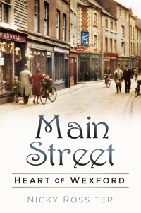
Wexford is one of the few towns or cities in Ireland where Main Street is still the main retail and commercial street of the town. In Dublin this honour goes to O'Connell and Grafton Street; in Cork it is Patrick Street; but in Wexford, Main Street is the hub and the site of Wexford's hidden historical gems. Main Street: Heart of Wexford contains little-known photographs, interesting advertisements and intriguing information about the street, such as the presence of a bag factory on South Main Street, Frank Hall of Radio Telefis Eireann being the official opener of the Book Centre in Wexford on 13 June 1975, and that Lamb House was a shop at the top of Anne Street on the south side and had a life-size lamb as its shop sign. Both insightful and comprehensive, this book is a wonderful history concentrating on the principal street of Wexford.
Sie lesen das E-Book in den Legimi-Apps auf:
Seitenzahl: 231
Veröffentlichungsjahr: 2018
Das E-Book (TTS) können Sie hören im Abo „Legimi Premium” in Legimi-Apps auf:
Ähnliche


To my family: Anne, Mark, David, Kate, Paula, Ellie, Finn, Lola, Ziggy, Jude, Jack and Noah
With special thanks to Mr & Mrs James O’Connor, whose encouragement and access to research materials assisted so many of my publications
First published 2018
The History Press
The Mill, Brimscombe Port
Stroud, Gloucestershire, GL5 2QG
www.thehistorypress.co.uk
© Nicky Rossiter, 2018
The right of Nicky Rossiter to be identified as the Author of this work has been asserted in accordance with the Copyright, Designs and Patents Act 1988.
All rights reserved. No part of this book may be reprinted or reproduced or utilised in any form or by any electronic, mechanical or other means, now known or hereafter invented, including photocopying and recording, or in any information storage or retrieval system, without the permission in writing from the Publishers.
British Library Cataloguing in Publication Data.
A catalogue record for this book is available from the British Library.
ISBN 978 0 7509 8832 2
Typesetting and origination by The History Press
Printed in Great Britain
Contents
Introduction
About the Author
1. History
2. Places and Events
3. Occurrences
4. People
5. What Was Where
Introduction
Wexford is one of the few towns or cities in Ireland, and indeed the United Kingdom, where Main Street is still the official name of the main retail and commercial street of the town. In Dublin this honour goes to O’Connell or Grafton Street. In Cork it is Patrick Street and in London Regent Street or one of a myriad of other roads. In Wexford the Main Street is the location of most of the shops and as such its length is still traversed regularly by locals and visitors. Despite this there are hidden gems of buildings and past history that are overlooked.
Our Main Street is ‘topped and tailed’ with two ancient settlements: at the north end is Selskar, reputed to be the Celtic origin of the town, while to the south is Stonebridge and the Viking section of Wexford. Both are generally incorporated in Main Street and therefore they are included here.
In an earlier book I looked at the streets of Wexford but avoided Main Street because it would have doubled the size of that volume.
This book will look at the development of Main Street and its division into North and South Main Street. It will trace – where possible – the development of particular premises through directories, old advertisements, historical documents and anecdotes.
Wexford’s Main Street is almost 100 per cent commercial with very few public buildings located there. This was not always the case and some of the earlier uses for familiar edifices or sites may surprise even the natives.
The material included will broaden our understanding of the historical commercial growth and decline of a port town that is also the county administrative centre.
The majority of illustrations are directly from my own collection or provided by friends. If any copyright or attribution is infringed please let me know and it will be corrected in any future edition.
Background
Main Street is probably one of the oldest thoroughfares in Wexford. Unfortunately, until the 1800s it was one of the least mentioned, partly because the term and title Main Street was not in common use. This refers not just to Wexford but also to other countries where the principal streets might be called Market Street or High Street. Even in the United States, where main street exists but has a different meaning, it is believed to date only from around 1810.
We all too often forget that religion played a huge part in the lives of our ancestors well into the seventeenth century. People saw themselves as being from a parish rather than a street, even in urban environments like Wexford. The parish, in turn, gave titles to the streets and these were usually saints’ names such as Ivory’s (Iberius or Ibar), Bridget’s, or perhaps Selskar from the abbey that dominated it. Matters are further complicated by what are seen as old maps but which were drawn more from memory and descriptions that show a street depicted as Main Street from an era when it almost certainly did not have such a designation. Likewise, history books can tell us tales of Cromwell’s troops ‘rampaging along Main Street from the Castle’, again at a time when such a title did not apply to that street. In fact, ‘rampaging into Stonebridge’ would have served better.
As commerce increased we are indebted to directories such as Slater’s and the magnificent Bassett’s, but again while giving us some excellent information they also cause confusion in that many businesses are listed with an address as simply ‘Main Street’, or even when listed with a number it does not tell us what numbering system applied at the time. We do not know exactly when the designations of North and South Main Street began to be used.
There is even confusion over the building numbers because sometimes people were rather cavalier in deciding a number and then more often than not, even with reliable numbering, buildings were expanded and might incorporate two earlier buildings but use only one house number with the other lost. Even in the twenty-first century, builders, developers and owners seem to conspire against the historian. There are now two sets of premises with the addresses 98 and 100 South Main Street. One of these pairs actually disrupts the whole numbering system, bringing even numbers to the side of the street used for odd numbers.
About the Author
Nicky Rossiter, as locals say, ‘was born and reared in Wexford’. He has been writing about local and social history for three decades and this will be his thirteenth full-length book on the town. He stresses that other than one such title all the material has related to the actual town of Wexford –‘inside the ring road’ – and is still not an exhausted seam of heritage and history.
Nicky has been published in various newspapers, magazines and journals and broadcast locally and nationally, including a regular series on South East Radio called ‘Stories’. He was the founder of Wexford Youth Theatre and wrote a number of plays for them, which were performed on stage and radio.
Nicky lives outside Wexford with his wife Anne and continues to research the town and its history.
1
History
The Viking Town
It was with the settlement of the Norsemen in this area that we would see a town begin to develop. The harbour was often the most important place in a Viking town and Wexford would not have been very different, although what later became Main Street would probably have made up much of the seafront. Here, boats were loaded and unloaded with goods and animals. Markets were held on the rudimentary quay that was very different from that of today or even two centuries ago. Nearby, boat-builders, potters, leatherworkers, carpenters and other craftspeople were busy in their workshops. The town was a self-sustaining unit with people making or trading the essentials of life. Wexford continued to grow over the next 200 years with trails developing into rudimentary streets.
Norman and Medieval Wexford
After 1169 and the coming of the Normans, Wexford developed even further as a town. The following description of a medieval town could well have described the Wexford of the period:
Outside the wall, all the town’s rubbish is dumped. Pigs and dogs root around in the muck. Inside the walls there are many grand buildings such [as] the homes of the merchants, a monastery and the churches. The lanes are busy with people, especially on market day and on fair days, when people come from miles around to visit the town. They trade in cloth, in food and in other products. There are beggars, rich men and foreign traders, all mingling in the narrow lanes and on the quays. The town does not smell very nice. The butcher’s shops in areas called The Shambles are the smelliest of all apart from the tannery. The tanner turns animal skins into leather keeping them in pits of animal excrement. There are signs hanging from many of the shops and they display pictures instead of words. This is because the majority of people cannot read or write. People come to recognise the pictures for the most popular shops. On the street corners are barrels full of water because most houses are wooden and the water barrels are there in case of fire.
In the medieval town daily life was very regulated with a typical timetable:
4 a.m.: The bell rang to announce the first Mass of the day and the end of the nightwatchman’s duty.
6 a.m.: Shops and market stalls opened.
8 a.m.: Foreign merchants were allowed to start trading.
9 a.m.: Breakfast.
3 p.m.: Most shops and market stalls closed.
8 p.m.: Curfew bell. Town gates closed, houses shut up, the night watch began.
This picture shows North Main Street looking south from the Bullring. Tommy Roche’s public house replaced Jack Fane’s, where Tommy had worked as a barman. Hamilton’s is on the right. The metal pole for carrying electricity wires was a common sight on our Main Street. (Rossiter Collection)
Looking at Wexford’s Main Street today we see a vastly changed area from those Viking and medieval ‘towns’. In fact, what we now call Main Street divided into North and South is made up of a number of old streets that have been subsumed and adapted into that one long commercial stretch running parallel to the harbour. If we did not divide the street it would probably rightly claim the title of the longest main street in Ireland at 0.46 Irish miles, or 0.59 statute miles. There is an old Wexford saying about the Main Street that says, ‘the further it goes the meaner [pronounced mainer] it gets’. However, in true Wexford fashion the saying never states which end this starts from, so people from each end can still feel good.
Starting at the north end of what is commonly thought of as Wexford Main Street, we actually walk on Selskar Street before entering what was once Foreshore Street to take you to the Common Plain, or the Bullring as it is now called. We then proceed along Main Street North and South – together once known as Fore Street – before ending our sojourn at Stonebridge. It is difficult to ascertain when the north and south designations were added because many of the older advertisements referred simply to Main Street. This also causes problems in locating some of the older shops. The older use of Fore Street reminds us of the general geographic origin of names with Fore Street and the next street away from the seafront as Back Street, later Upper Back Street and eventually High Street. The Main Street designation probably dates from the proliferation of shops and other businesses that made it the principal or main street of Wexford. But if one looks above the shop signs you will see in many instances the original buildings from the time when they were family homes, including examples of the multi-paned ‘Wexford Window’.
The topography of a town such as Wexford 1,000 or more years ago is hard to imagine by those used to its twenty-first century configuration. The first thing we must accept is that there are no shops and this in essence means that what we know as the Main Street was a very different environment. Physically Wexford was very different in those times in that the waters of the harbour covered what we now see as the quay front. Try to visualise the town without buildings and look at the physical contours of hills and depressions such as the steep decline from Main Street at Anne Street and the rise in the ground of South Main Street after Peter’s Street. Features such as these remind us of the contours of the ‘Celtic’, Norse and Norman towns or settlements.
The traditional explanation for the existence of our long Main Street is that the original settlement of Wexford was in the Selskar area with the later Norse settlement located at the opposite end of the present street around the Bishopswater River. Interaction and trade between the two was said to result in the development of a trail that later became populated and thus evolved into Main Street. This is a very simplistic view but, like all such myths, it can have some basis in fact.
Selskar Street
This section of the street takes its title from the parish of Selskar, which in turn borrows from the Church of St Sepulchre, which we recall as Selskar Abbey. A less ecclesiastical derivation is also possible. Selskar may mean ‘Seal Rock’. The Norse used the word ‘skar’ to refer to rocks, as in Tuskar, and the Rock of Wexford is situated just 150 yards from the abbey. Dr George Hadden, writing in the Journal of Wexford Historical Society and with a keen eye for land and seascape and an unrivalled knowledge of the history of Wexford town, postulated the existence of a prehistoric market located around the present Cornmarket, centuries before the arrival of the Vikings. Where Hadden had located an early Christian oratory at Selskar, Dr Billy Colfer suggests a larger, circular monastic enclosure, partly delineated by the curved street pattern in the Selskar area. A settlement would have grown around the oratory, benefiting from and supplying services to the monks.
In common with most towns, the street was primarily residential with the townhouses of the gentry mixed with the more humble dwellings of the general population in places such as Trimmer’s Lane and Well Lane.
Foreshore Street
This is a self-explanatory name for the section of our present North Main Street stretching from Selskar Street (roughly at George’s Street) to the Bullring. As the name suggests, the waters of the harbour once brushed the land here. It was renamed Lower Main Street in the 1700s but later became North Main Street. Buildings were erected on the western side and as the land was reclaimed for a growing population others grew up on the opposite side.
The Bullring
This area of Main Street connects to the Common Quay via Common Quay Street and, having once been noted as the Common Plain, we surmise that it was an area for fairs and markets in the days prior to the development of the modern retail shop.
The Golden Mile
This is the common designation, probably coined by estate agents – in Wexford parlance auctioneers – describing the Main Street from the Bullring to Coffey’s Hill. This is, and has always been, the hub of commerce for Wexford and includes almost equal portions of North and South Main Street. It is in this area of Main Street that the eponymous description of Wexford as ‘Tumbling Down’ in Billy Roche’s book is most striking. The houses on the seaward side usually had (and still have) cellars or lower floors covering the land sloping down towards the seafront. On the opposite sides many of the later shops had dual-height ground floors where they expanded into the yards or gardens at their rear, sloping upwards to High Street or Back (Mallin) Street.
Stonebridge
Main Street ends its stretch southward at King Street with the final portion consisting mainly of Stonebridge. It takes its name from what was a small bridge located there. It has been called Wexford Bridge and in 1764 it was known as Jew’s Bridge. The bridge was built over the Bishopswater River and may have marked the northern gate of the earliest Norse or Viking settlement.
Dr Hadden visualised the Norse entering by the Bishopswater River and hauling their longships ashore just below the knoll or mound on which the present military barracks is situated. In 1987, when businessman Colman Doyle began clearing a site at the corner of Bride Street and South Main Street, some timbers were noted protruding from the ground. With the agreement of Mr Doyle the National Museum was informed and archaeologist Edward Bourke was dispatched to Wexford to excavate. Bourke later described finding the remains of ‘two Viking houses and a lean-to shed. House One was of a single post and wattle construction with a floor of hardened estuarine mud. Another house had walls of sharpened planks, driven directly into the earth, with a floor similar to house One.’ The walls of the lean-to building were also of plank construction, the floor was composed of sand, and the roof was probably thatched with straw or reeds. Both houses were provisionally dated to the early eleventh century. This gives us the first concrete indication of the type of houses that would have populated Main Street more than a millennium ago.
Over the following centuries Wexford grew greatly in size and importance, as evidenced by the description of the town by Giraldus Cambrensis in 1169 as ‘surrounded by ramparts probably of stone’. Norse Wexford was a trading post of some significance. Giraldus tells us that the Normans tried to commandeer a ship carrying corn and wine from Bristol but were foiled in the attempt by quick-thinking sailors. The abundance of ships belonging to the Wexford Norse is attested by references in the annals to their part in the raids on Cork and Waterford and in their ability to transport numbers of troops from Wexford to Dublin in 1128. Giraldus also states that Wexford traded hides of animals for imported wine.
Dr Billy Colfer considered the Norse Wexford to be slightly larger and notes, ‘There is a natural break in the street pattern where the curved line of the street at Cornmarket could well represent the line of the Norse defences’, indicating the growth of Norse Wexford from that original site. This is supported by a report in Hore’s History of Wexford that, in the eighteenth century, the remains of the Norse wall could be seen at Common Quay. Colfer continues, ‘If, as seems probable, the Norse town ended at Cornmarket, it would have consisted of four intramural parishes with a combined area of about twenty-five acres. This point is substantiated by the fact that market places were typically situated to the south-east or east of monastic enclosures and Cornmarket is about 200m directly south-east of Selskar Abbey.
The area just outside the Norse town – the present Bullring – may have been held in common by both ‘sides’ and may be why even centuries later in 1621 it was referred to as the Common Plain. Further development would ensue with the arrival of Norman forces in 1169, including the extension of the town to take in the older settled area around Selskar. But this was a very different street to what we see today. The buildings would have been well scattered with gardens and animal pens to provide food for the households. Buildings would have been single storey and only over a long period of time would construction develop from wattle and daub through timber to stone-built houses. Even in London it took until the late 1600s for most buildings to be constructed of stone.
Throughout this and for most of its later history we must bear in mind that Main Street was residential, as were all towns of an era prior to ‘ready money’ and generally manufactured goods. During that time most goods that could not be made at home or by neighbours were purchased in a few very small shops attached to manufactories, such as those producing gloves, hose and hats in areas such as Cornmarket or on the quay. Otherwise people used the fairs or markets or bought from travelling peddlers.
In the Middle Ages there were few permanent shops but every town had a market. Often if you wanted to buy or sell anything you went to the local market or waited for the regular fairs. Medieval shops were really workshops where the customer could walk in; there were no glass windows. In towns in the Middle Ages there were craftsmen such as carpenters, bakers, butchers, blacksmiths, bronze smiths, fletchers (arrow makers), bowyers (bow makers), potters, coopers, and barber surgeons who both cut hair and pulled teeth. The number of shops grew in the seventeenth century. Meanwhile, glass became much cheaper and in the eighteenth century shops began to have glass windows. By the eighteenth century there were many small shops in every town, including shoemakers, drapers, milliners, haberdashers, bakers, butchers, grocers, fishmongers, booksellers and gunsmiths.
As stated in the article ‘Consumption and Living Conditions 1750–2016’, drawings of Dublin in the mid-eighteenth century showed street traders hawking an array of goods from coarse earthenware to turf and foodstuffs for ‘households of the middling and lower orders’. It also notes that the communications revolution from the 1840s facilitated retailing expansion: ‘Small shops proliferated in smaller towns selling dry goods, food, drink, hardware and household goods.’ It was in the mid- to late nineteenth century that the larger shops such as Musgrave’s in Cork and Clery’s in Dublin were set up. Wexford would have followed a similar timeline in the establishment of its retail concentration on Main Street.
Looking at the buildings that now populate Main Street, we note that most date to the early 1800s, which was a major period of expansion in the town with the construction of the linear quay front replacing the many wharves and jetties that often later became lanes leading from Main Street. Even one of our older buildings, the famous Kenny’s Hall where Cromwell is said to have resided in 1649, is recorded as ‘reputedly incorporating fabric of earlier seven-bay two-storey timber-frame house, c.1600’. Prior to that it is most likely that the houses were lower as residences. With retailing growing there was a tendency to build upwards with the ground floor as a retail outlet and two floors of living quarters above, giving the more familiar three-storey house of Main Street.
Up until these major developments there was little need for a major drainage system. Toilets were drained into cesspits and ‘clean’ waste water would have been tossed into the ‘open drain’ that ran along the centre of the road or street. With increased traffic, and as the street became commercialised, this drain was covered with flat slabs making ‘box drains’. It was only with the introduction of piped water that more sophisticated drainage systems had to be installed.
Finding the first mention of a Main Street proves difficult, but as we look back through various directories we find the following:
1764 – Flesh Market; Cornmarket; Back Street; Shambles; Keizars [sic] Lane; Ferryboat Quay; Medows [sic] Quay; Bennett’s Quay; Common Quay; Gibson’s Lane; Custom House Quay (principal quay). (Griffith’s Valuation)
The first mention is in 1820 in Pigot’s Directory:
1820 – Back; Main; Selskar; John; Cornmarket; Slaney; Westgate; Old Pound; Common Quay; Faith; Custom House Quay; Bullring; Castle; Monck; Anne; Mary; Ram; Paul Quay; Stonebridge; George.
The Dublin Almanac of 1844 gives us the first description of the street:
Quay c. 800 yards from bridge to just above barracks. Another parallel 1000 yards long, narrow, about 130 yards from quay. Another Street was c. 220 yards from quay. Lanes were connecting. ‘Airy district 450 × 130 winging west side of town’s middle part. Straggling airy Street extends 500 yards NW along Taghmon/New Ross road to obelisk near windmills. Another road goes 250 yards NE to new gaol. Bullring, Courthouse, Parish Church, diverging streets to Back Street & Selskar, Johns Lane/Chapel Lane to John Street.’
The oldest building in any town is difficult to ascertain, and indeed this might not have been on Main Street. In Wexford one of the first buildings to be identified is what we often called Kenny’s Hall, which stood on the site now occupied by Penney’s. Although much altered over the centuries, it was the residence of Colonel David Stafford in 1649. It later passed through a number of owners and these will be considered in a later section. We are aware of the building and date because of the legend that Oliver Cromwell spent some time there.
Hore’s History of Wexford states: ‘Nearly all the houses in the Main Street … were the residences of better class people in the past, the business portion of the town being Cornmarket and Back Street.’ The landed gentry had townhouses in which they spent most of the winter and entertained their friends at other periods such as Assize Week in spring and summer.
The Nunn family had townhouses in both north and south Main Street, later occupied by Rossiter’s ironmongery and Keegans respectively. Harveys of Killiane had their town residence in what later became the Imperial Hotel on Selskar Street. Hore states, ‘The old Norman family of Herron resided in the eighteenth century in the large house on South Main Street now occupied by the constabulary.’ Colonel Tottenham lived ‘in a spacious house’ near the Bullring that was later occupied by Godkins. Miss Kitty Ford of Ballyfad House lived for many years in another house near the Bullring that later became Mernagh’s confectionery shop. Leigh’s of Rosegarland also had their town house facing the Bullring. Archdeacon Elgee – father of ‘Speranza’, the mother of Oscar Wilde – occupied the rectory on Main Street that was later Messrs Wheelock’s. Esmonde’s town house was further south, almost facing Anne Street, and part of it was used as a booking office for the coach service to Dublin.
Again from Hore writing in 1906 we learn, ‘about eighty or ninety years ago there were no shops in the Main Street then called Fore Street. All the houses were residences of landowners and persons of independent means. All that class has disappeared from Wexford within the last sixty years and their residences have been converted into shops.’
Even then Main Street retained a very high number of permanent residents, as we see in a casual glance at the census of 1911.
At number 2 we had the Richards family, consisting of mother, father, two grown children and a servant. Meanwhile, number 11 gives us a picture of a business with ‘live-in staff’ connected to the retail shop. There were the Byrne family of five as well as four young adult males designated ‘boarder draper assistant’ and two female servants. At number 3 there was a family of two adults with four young children and the sister-in-law of the ‘head of house’. Finally, the Wheelock family at number 4 North Main Street had a household on census night of the head of the house, his brother and sister, three boarders and a servant, as well as a ‘visitor’.
A large number of the houses on the east side would have been owned or rented by people associated with the growing marine trade of the harbour. These often had jetties connecting the rear of the house to the seafront in order to access cargoes and boats. There is evidence in pictures of some of these homes dating from the late twentieth century of doors on a level of what must have been later cellars accessing a former shorefront many feet below the level of Main Street.
Shops then opened on ground floor areas, but it was not always a street of commerce and retail. Wexford Main Street has been home to churches, cinemas, hotels, newspaper offices and printing works, undertakers, a mechanics’ institute, trade union offices, a jail, corporation chambers, a courthouse, and reputedly a public house about every few doors along. An interesting quote in Jim Jenkins’s book Retailing in Wexford is that ‘one yard of counter is equal to 100 acres of land’, and this no doubt became more true as the consumer society grew in Wexford and elsewhere.


