Erhalten Sie Zugang zu diesem und mehr als 300000 Büchern ab EUR 5,99 monatlich.
- Herausgeber: The History Press
- Kategorie: Geisteswissenschaft
- Sprache: Englisch
For two thousand years London has been at the heart of Britain's development as a nation, providing a focus for its political life. The military element is now usually visible only through the pageantry which attends royal occasions, but this masks a more serious underlying intent. Frequently the target for both foreign invaders and domestic factions, it has been required to defend itself against everything from seaborne raiders to aerial bombardment and the threat of nuclear war. At the same time, the direction of military affairs has been centred on London, along with the military infrastructure of barracks, depots, magazines, dockyards and munitions factories. The evidence for much of this can be seen in the landscape, from the mediaeval Tower of London and the underground nuclear citadels in the urban centre, to the royal palaces, moated sites, airfields and anti-invasion defences in the suburbs and the green belt. This book describes the various elements of London's military heritage, and places them in their historical and social context. From the castles and strong-houses of the mediaeval and Tudor monarchs and statesmen, to the pseudo-fortresses of the Victorian militia and rifle volunteers; the airfields of the anti-Zeppelin fighters of the Royal Flying Corps, and the Battle of Britain bases of the RAF, to the pillboxes of the defences against invasion in 1940, and the anti-nuclear defences of the Cold War and beyond.
Sie lesen das E-Book in den Legimi-Apps auf:
Seitenzahl: 513
Veröffentlichungsjahr: 2011
Das E-Book (TTS) können Sie hören im Abo „Legimi Premium” in Legimi-Apps auf:
Ähnliche


Acknowledgements
Adrian Armishaw, Anneli at Stapleford Tawney, Alec Beanse, Jeff Dorman, John Guy, Lisa Harris and staff at Wickham Court School, Jeff Hogg, John Kenyon, Fred Nash, Eric Pearce, Mike Shackel, Richard Stewart of Funny Neuk, and Keith Ward.
Contents
Title
Acknowledgements
Abbreviations
Introduction
One
Prehistoric, Roman and Saxon London
Two
London 1066–1300
Three
London in the Later Mediaeval Period 1300–1600
Four
Stuart and Georgian London 1600–1815
Five
The Victorian Period c.1815–1914
Six
London in the First World War
Seven
The Interwar Years 1919–39
Eight
London in the Second World War
Nine
London in the Cold War 1946–90
Appendix 1
Prehistoric Camps
Appendix 2
Mediaeval Fortifications and Defensible Sites
Appendix 3
Barracks, Camps and Depots
Appendix 4
Some Drill Halls and TACs of the Volunteer Forces
Appendix 5
Command and Control
Appendix 6
Military Airfields and Aviation Sites
Appendix 7
The Militia in 1850
Appendix 8
Intelligence and Communications 1939–45
Appendix 9
Site Gazetteer
Appendix 10
Munitions Production and Logistical Support
Appendix 11
Military Hospitals and Welfare 1642–2000
Bibliography
Copyright
Abbreviations
Introduction
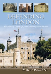
Over the centuries, London, as the political, commercial, financial and cultural centre of an expanding nation, and then an empire, has attracted intended invasion by land, sea and, latterly, by air. Britain’s island fastness insulated her from many of the wars that ravaged the continent of Europe, obviating the need for the vast fortifications that for so long characterised other great capital cities such as Paris, Vienna or Rome. Nevertheless, London was made defensible from Roman times, and there were times when insurrection, dynastic competition, civil strife or general social or political instability required individuals to fortify their homes just as the city chose to keep its walls in reasonable order. As Stuart kings raised royal household troops, perpetuating the pretence that Britain had no need for a standing army, these forces had to be housed, provided for and inspected. Over time, London became a garrison town, with barracks, ordnance stores and parades, and the application of industrial methods to warfare, with dockyards, gunpowder works and arsenals. If the Tower of London stood as the obvious and very visible symbol of military power, retaining a more than merely ceremonial significance into the 1950s, then many other public buildings such as Somerset House concealed their military associations. Burlington House in Piccadilly, built c.1664, taken over by the government in 1854 and nowadays home to the Royal Academy, is another example. In 1859 it became HQ of the 38th Corps Middlesex Rifle Volunteers, drawn from London’s artistic community, who remained there until an amalgamation with another corps took them to Duke Street, Euston as the 20th Corps (Artists’ Rifles). Another professional connection prompted the Dazzle Section of the Camouflage Workshop to be set up at Burlington House around the beginning of the First World War. Some years on, it became a focus for recruitment into various departments of Military Intelligence. Much former military activity, however, is now memorialised only in names: Tower Hamlets was the ancient district owing military service to the Tower of London; public houses such as The Volunteer (Epping), or The Artillery Arms (Finsbury); Brentford or Stoke Newington Butts, where archery was practised; and Artillery Lane and Gun Street in Spitalfields. At various times during the two world wars, the Crystal Palace, Lord’s Cricket Ground, Sandown and Kempton Park racecourses, Olympia and Alexandra Palace have all fulfilled a range of overtly military functions.
With the expansion of its military infrastructure, London became an ever more attractive target, suffering hitherto unimagined aerial bombardment in the First World War and witnessing at first hand the measures being taken to prosecute the war, with armies being assembled, munitions being manufactured and despatched to the front, and the provision of anti-aircraft and anti-invasion defences. During the Second World War, the military imposed itself on the landscape to an even greater extent, and Londoners grew accustomed to being surrounded by AA sites, camps and depots, training grounds, anti-invasion defences and munitions plants. This military colonisation was typical of every part of London and, allied to the effects of bombing, the vast numbers of men and women in uniform, and the ever-visible presence of ARP, the whole of the London area must have at best seemed like an enormous armed camp, and at worst a city under siege. While threatened invasion in 1940–41 failed to materialise, Londoners would still have regarded the takeover of the central districts by foreign governments, agencies and armed forces, as a virtual invasion, however benign. There was hardly a public or commercial office building in the City or the West End that was not given over to one form of martial activity or another. The permanent state of confusion caused by the presence of a bewildering array of Allied troops, many of them in a state of culture shock, was one of the factors that encouraged German POWs to plan a breakout and march on London, coinciding with the Ardennes offensive of late 1944. The V1 and V2 onslaught must have seemed like the final straw. During the Cold War, London remained the most obvious target for anticipated Soviet aggression. Despite attempts to decentralise both government functions and defence assets, in the event of a nuclear exchange London would inevitably have been obliterated, almost certainly precipitating the defeat of the West. Londoners failed to be convinced by government encouragement to ‘protect and survive’, a farcical delusion maintained until a mere twenty years ago. Since the early 1970s, threats have intermittently been posed by terrorist activity, eliciting further defensive responses.
Land is at such a premium in densely populated London that it is unsurprising that continual redevelopments have swept away much of the evidence of those defensive precautions. This book attempts to describe the works that were constructed and the rationale behind them. Survivals make up in quality what they lack in quantity. They include stretches of the outer defence lines of 1940, First World War anti-aircraft gun emplacements at Honor Oak Park and Cheshunt, the 1907 Vickers/Maxim machine-gun factory at Erith, and a Second World War pillbox and roadblock in the shadow of the Olympic Stadium at Bow. Amazingly, one can be fairly confident that further survivals are still awaiting rediscovery, and readers who might be so lucky are asked to observe three principles: to respect private property and privacy; to take appropriate care in potentially hazardous locations; and to report discoveries to local authority historic environment officers or museum staff.
Even as I write these words, a HAA site on the Olympic site at Hackney Marshes has come to light. Gun emplacements linked by a magazine, the GL radar ramp and a close-defence blockhouse remain from what was presumably ZE21.
I know, having spent the first twenty-five years of my life there, that London as a geographical entity means different things to different people, and the area covered by this book is clearly arbitrary, roughly covering the area inside the M25 London Orbital motorway. This of course overlaps the surrounding counties, out of which the outer London boroughs have been carved since 1974. In 1939 seventeen of Surrey’s thirty-two local authorities, forming London’s Civil Defence Region Number 9, lay within the area now regarded as Greater London. Many units of volunteers and Home Guard had affiliations with Essex, Kent or Surrey. Additionally, all of Middlesex and parts of Hertfordshire have been swallowed up by the metropolis, and these links and historic associations have been recognised in the text.
Mike Osborne January 2012
one
Prehistoric, Roman and Saxon London
Prehistoric London
Until a good while after the second Roman invasion, the site of what we now know as the City of London, if it existed at all, had little significance. It was not a tribal centre as Colchester was, it was not a centre of trade as St Albans may have been, and it was not a communications hub despite the fact that there is likely to have been a ford around Westminster, accompanied by a small settlement on one of the islands nearby.
The invasion of the Belgae around 100BC led to a greater density of population in the south-east, although not generally along the lower reaches of the Thames, however there was an increase in movement if not settlement in this area, with the ford and trackways opening the area up to traders. It is possible that the Old North Road was in use in pre-Roman times and this may have forded the Thames near Southwark where there have been finds of contemporary pottery. Another track may have run eastwards from around Windsor to cross the Lea at Walthamstow. The most likely centre of population in the London area at this time was in the south-west around Kew, Kingston and Richmond. Although signs of warlike activity have been found in the Thames, notably the magnificent Battersea Shield, dated to 300BC, these may simply indicate ceremonial sites where arms were deposited in the river as offerings to the spirits. Other finds however, which include a shield with a spear embedded in it, may be more tangible signs of actual conflict.
Iron Age settlements consisting of small clusters of roundhouses, perhaps enclosed by a ditch and a bank with a stockade as much to keep stock protected from wild animals as to keep the inhabitants safe from hostile tribes, tended to hug higher ground above river valleys. There were a number of larger settlements in the Greater London area, some of them meriting the status of what are generally known as hill forts. Caesars Camp at Holwood Park, Keston, is a large Iron Age hill fort, measuring 1 mile (1.6km) around its perimeter, and enclosing an area of 43 acres (17ha). It has a single bank and ditch (univallate) on the north side, but is bivallate on the west, its bank rising in places to 40ft (12m). The rest of its circuit of banks and ditches was destroyed by nineteenth-century landscaping. Uphall Camp in Ilford, another significant fortified enclosure in a strategic location, dominating Barking Creek and the Thames and possibly representing a high-status regional centre of the people who are remembered as the Trinovantes, is a large, univallate fort covering 60 acres (24ha). There is evidence for a double ditch along the side nearest to the River Roding, and in the interior, ring ditches signifying roundhouses and rectangular structures with post holes, dubbed ‘four-posters’ in the excavation report and interpreted as store houses, have been found. The rampart was up to 13ft (4m) in height, and the fort appears to date from the end of the Middle Iron Age. Loughton Camp was sited on a spur overlooking a tributary of the River Roding. Its oval univallate defences, with a ditch 45ft (14m) wide, enclose an area of 6.5 acres (3ha). Another small fort, also now in Epping Forest, was Amresbury Banks, a plateau camp with a ditch 10ft (3m) deep and 22ft (6.5m) wide. At the Woolwich Power Station site, roundhouses were found surrounded by massive ditches.
Roman London
Britain was subject to two Roman invasions nearly a century apart. The first was little more than a punitive reconnaissance in force, aimed at warning off the British tribes that were seen to be backing resistance to Rome across the Channel in Gaul. In 54BC, after an initial barely opposed landing, Julius Caesar met stiffer opposition from Cassivelaunus, who had been given command of the temporarily united tribes. His troops skirmished with the Romans, perhaps in the vicinity of Westminster or the future London Bridge site, defending a ford and a riverbank fortified with sharpened stakes. Having no more than interrupted the Roman advance, Cassivelaunus was defeated after the Roman army stormed his main hill fort, probably Wheathamstead on the River Lea near St Albans.
The second invasion was in AD43 when a Roman army of perhaps as many as 30–50,000 troops under Aulus Plautius landed at Richborough. The Roman army advanced through Kent defeating the Britons on the Medway in a battle lasting two days, pushing them back on London, where the Britons crossed the wide and shallow Thames by secret fords. The Romans camped south of the river, where they were joined by the Emperor Claudius. The army forced a crossing, defeating the Britons who retreated into the trackless wastes of Hackney Marshes and the boggy area around the mouth of the River Lea, possibly attempting to lure the Romans to follow. Further Roman successes resulted in the capture of Colchester and a speedy end to British resistance.
Morris suggests that a Roman army of 50,000 men would have had detachments guarding the 80-mile long (128km) lines of communication back to the coast, and also defending bridgeheads north of the Thames. While it was generally accepted that there had been no attempt to fortify the site in the early days, evidence has been unearthed of a double-ditched enclosure with characteristically military features on the eastern bank of the Walbrook with a corresponding northern section at Bishopsgate; defences that had been slighted by AD50. A further, apparently contemporary, but much smaller ditched enclosure found at Park Street in Southwark may represent a camp associated with the first arrival of the legions at the site, tying in with what appears to have been a marching camp on Blackheath on the Dover road. This, and other Roman roads, may have been laid down before a permanent bridge was built. The line of Watling Street clears the river via Marble Arch, apparently running north from a possibly temporary Westminster crossing near the present Houses of Parliament. This may have been on a long-established site of a ford or a pontoon bridge, and there might have been another bridge or a ferry upstream around Chelsea, Putney or Battersea. The level of the river was much lower than it is now, possibly only up to 40ft (14m) at its maximum depth. The island of Westminster is a likely place for a Roman pontoon bridge, enabling the army to cross in pursuit of the retreating Britons in AD43, and making it possible to establish a secure bridgehead.
Around AD47–55 London was established on a green-field site east of any previous settlement and the road alignments were altered accordingly. The first permanent bridge was built near the present London Bridge, and massive timbers forming the base for a bridge pier, dated to AD85–90, have been found on the north bank at Fish Street Hill. Roman London began life primarily as a supply depot but was already a large settlement by AD61, when it was sacked. Following the death of her husband, Boudicca the Iceni queen and her daughters were disinherited by the Romans and raised a rebellion. Most of the Roman troops under Suetonius were occupied in Anglesey putting down the Druids, so the Iceni, who had meanwhile destroyed the towns of St Albans and Colchester and defeated the Ninth Legion, had a clear run at London, their third major target. Suetonius hurriedly marched on London with not many more than 10,000 troops against possibly 120,000 tribesmen. Judging his forces too weak to resist the Iceni on ground not of his choosing, he evacuated as many as would leave. London, without walls, was virtually undefended and the Iceni slaughtered the inhabitants and fired the buildings. Evidence from this conflagration points to population clusters astride the Walbrook stream, around the Bank of England, along the Colchester road through Aldgate, and on the South Bank. Numbers of the dead at the three towns together are estimated at upwards of 70,000, as reported by Tacitus writing from eyewitness accounts. Suetonius then brought the Britons to battle, defeating them somewhere to the north of St Albans and, although some resistance continued, Boudicca chose suicide.
London had been obliterated and very little happened on the site for ten years while Roman efforts went into the conquest of the rest of Britannia. Evidence of a double-ditched enclosure at Plantation House to the east of the Monument, suggests a post-Boudiccan fort, built to protect urgent rebuilding works that were carried out on the port facilities. This fort itself had been built over within a generation, covering hundreds of skulls that may have been evidence of Roman retribution. By the end of the first century the main road network had been laid down with London not only as one of its major nodal points but also representing the most important port of the province. A period of peace and consolidation provided an opportunity for London to develop as the most impressive of Roman towns in Britain, a worthy home for the provincial government. The earliest Roman settlement appears to have been around Leadenhall. A V-shaped ditch found on the eastern side of the Baltic Exchange site in St Mary Axe was dated to the first century and was 7ft (2.1m) deep and 13ft (4m) wide. It may represent an early defensive ditch or boundary and had been in-filled between AD130 and AD150, at the time the settlement began to expand.
Early in the second century, a stone-walled fort was built at Cripplegate, covering an area of 12 acres (5ha), and over the years opportunities to explore surviving parts have presented themselves through bomb damage to surrounding buildings or redevelopment. The fort apparently escaped damage in the fire of the AD120s, soon after it was built. It was the usual playing-card shape with walls 4ft (1.2m) thick, a gate in the middle of each side and an internal turret at each corner. The wall was around 15ft (4.5m) high and had a rampart walk accessed by small, square turrets placed at intervals on the inside of the walls. The base of the northern part of the fort’s west gate survives in the underground car park by the Museum of London. It consisted of twin arches in-between two-storey projecting towers containing guard chambers. Wood Street was the main north-south thoroughfare of the fort leading to the north gate, which became the mediaeval Cripplegate. Traces of Roman barrack rooms have been excavated either side of the road. The fort was large enough to accommodate around 1500 men, and this would have included a force acting as police commanded by the legatus iuridicus,an officer of the civil authority. They were probably auxiliaries but may have included detachments of legionaries. Additionally, the fort accommodated troops in transit on the road to or from Richborough, and soldiers who needed to be in London on official business. London’s population variously peaked at 30,000 or 45–60,000 in around AD140–150.
1 A view of the external face of London Wall at Tower Hill, standing to a height of 35ft (10.6m). The lowest Roman courses are strengthened with layers of red tiles.
2 St Giles Cripplegate, a stretch of Roman wall with the lower courses of a mediaeval bastion, which was added in the thirteenth century.
During the rebellion of Clodius Albinus and the reign of his nemesis Septimius Severus (190–210), London’s strategic importance increased over its commercial significance, and it needed some proper defences beyond the existing isolated fort. London Wall was built by AD225, using some 85,000 tons of Kentish rag stone, brought from the Maidstone area in, it has been estimated, around 1300 barge loads. Running in six straight lengths, two of which were formed by the western and northern walls of the pre-existing fort, London’s Roman walls did not initially extend along the waterfront. The wall was 21ft (6.5m) high and 9ft (2.7m) thick, with a sentry walk on top and a V-shaped ditch 14ft (4.2m) wide and 5ft 6in (1.6m) deep. It has been suggested that the ditch, an obstacle of no great consequence, may have been water-filled from the various streams and rivers. The wall enclosed 240 acres (96ha), and was 3 miles (4.8km) long, making London the largest walled town in Roman Britain. At its north-west angle, these walls took in the fort whose wall, being thinner than the new wall, had to be doubled in thickness on the west and north. Four gates were built in the new walls – Ludgate, Aldgate, Bishopsgate and Newgate – the last, excavated in 1909, was shown to have had a double roadway running between two projecting towers containing guard chambers. That to the north projected 18ft (5.5m), but the southerly one projected only 8ft (2.5m). Aldersgate, to the west of the fort, was cut through the wall a little later than the rest, perhaps when the fort’s West Gate was blocked up, and the existing north gate of the fort became Cripplegate. The projecting towers of these Roman gates may have been adapted to carry artillery at the same time that bastions were added to the walls. As well as the massive catapults, siege towers and battering rams used by the Roman army in the field, a range of lighter catapults firing bolts, stones or fire pots was available for mounting on the towers of forts and towns in a defensive role. Roman town defences in their final form were often the result of many decades, if not centuries of piecemeal development. An earthen bank and ditch with perhaps a palisade might have had stone gateways substituted for timber ones. Then the bank could have been cut back for a stone wall to be inserted, and then thickened to take a fighting platform. A final addition may have been the addition of external bastions to the face of the wall, which were sometimes bonded into the existing masonry
The end of the second century and the first decades of the third saw raids from the sea for slaves and portable treasure carried out by bands of deserters that were ultimately defeated by imperial power on land and sea. The danger from raiders sailing up-river was clearly anticipated, as a late third-century signal tower has been found at Shadwell. This may have been one of a chain, built to warn of approaching raiders. It was a square, stone tower within a ditched enclosure, a fairly common late-Roman structure. There is a suggestion that Uphall Camp at Ilford had later Roman occupation, possibly of a military nature, as the corner of a ditch has been discovered, possibly suggesting another signal tower, but there is nothing conclusive. London’s later defences were built in the context of further imperial power struggles. Carausius ruled Britannia outside the Roman Empire in 286–293, and was then assassinated by Allectus who ruled until 296, when he was killed by his own troops, Frankish mercenaries who, on fleeing to London after their defeat near Silchester (Hampshire), were narrowly prevented from sacking the city by Constantius Chlorus, who arrived by ship in the nick of time and slaughtered them. Constantius then restored Britannia to imperial rule, and Londoners would have witnessed part of this denouement when a battle was fought in the Thames. A small sailing vessel has been discovered near Westminster Bridge, and it appears to have been sunk by heavy stones being thrown or fired into it, possibly by catapult. The signal towers were part of a wider system of coast defence based on a chain of forts such as Walton-on-the-Naze (Essex) and Reculver (Kent), which protected the coast and the approaches to the Thames Estuary.
Figure 1 Roman London.
Continual raids by Irish, Picts, Franks and Saxons caused chaos, culminating in the disastrous events of 367 when Nectaridus, count of the Saxon Shore and responsible for coast defences and the Roman fleet, was killed by raiders, and a Roman army was badly mauled in an ambush. Count Theodosius was despatched with an army from Spain in time to restore order and to expel the invaders, and it was probably this episode that prompted an urgent attempt to strengthen London Wall. As happened at other places throughout the empire, this was achieved, under Valentinian, by the addition to the eastern walls of solid D-shaped bastions, roughly 180ft (55m) apart. These were up to 30ft (9m) in height, and probably capable of mounting light artillery. Possibly symptomatic of the urgency of this operation, attempts had been made to bond only two of the new bastions into the existing wall. The most westerly was Bastion 11, under All Hallows church, and there appears to have been some reliance placed on the marshy valley of the Walbrook as a natural obstacle. Fields of fire seem to have been cleared for the artillery, and the original ditch was filled in, with a wider and deeper one being dug in its stead. In addition to these new bastions, excavations in 1976–77 found that a riverside wall had finally been built of small blocks of rag stone held together by internal timber lacing, the whole built on piles on the unstable riverbank. Once again, such was the urgency here that any available materials, including an early third-century commemorative arch and tombstones, were all used. Where the line of the Roman wall now runs to the east of the White Tower, there is evidence for an internal turret, and this may be much earlier than the bastions, one of which formed the basis for the twelfth-century Wardrobe Tower. A strongpoint may have been formed in this south-east angle of the Roman defences, protecting the riverside approaches. It has been suggested, partly on the basis of the intervals between them, and partly from excavation, that the mediaeval towers along the waterfront – the Lanthorn, Wakefield and Bell Towers – may have been built on top of Roman bastions. To the west of the Lanthorn Tower there is evidence for a postern or sally port, set in a re-entrant angle of the Roman wall and opening onto the quayside, and stone floors, possibly dating from the fifth century, have been uncovered nearby.
As the empire lost its grip on its northern provinces in Germany and Holland it became less easy to export wheat from Britain to those places via London, and Southampton took over some of this trade using the French Channel ports. In AD410 the Romans announced that Britain could expect no further help from Rome and would have to look after itself. London, a Romano-British town living a Roman lifestyle, attempted to remain the seat of civil power but the general fragmentation of the established order, coupled with an increase in hostile incursions, steadily eroded the importance of what had proudly become Londinium Augusta. It retained the role of fortress for a while longer, being used by the succession of short-lived rulers trying, mainly unsuccessfully, to fill the vacuum following the end of Roman rule.
Saxon London
Archaeological evidence and artefacts all point to the fact that trade between London and the continent of Europe continued throughout the fifth century. After the defeat of the Britons by Hengest and Horsa at Crayford in 457, London and the Thames formed a physical barrier that prevented the Saxons of Kent and those of East Anglia from joining together as one cohesive territory under Hengest. In London, any organised settlement was likely to have been either in the fort or in the south-east corner where the Tower of London would eventually stand. There was an ecclesiastical centre at the west end of the walled area, and the riverside wall was remodelled early in the fifth century. It is also possible that the Saxon settlement at Mucking, downriver from London, was part of an early-warning system. After 592, control of London passed to the East Saxons under Aethelbert of Kent, with the Thames representing the boundary between Wessex and Mercia, and dominance oscillating between the two kingdoms. By the seventh century, the economy had begun to recover, with coins being minted in London. Within the city, the centre of gravity switched from the old Roman town to a new settlement, Lundenwic, now occupied by Fleet Street and Charing Cross; this area was a good deal safer than the decaying Roman waterfront with its dangers both real and imagined. There was a possible fortified royal centre at Aldermanbury within the old walls, lasting until the mid-ninth century. Offa of Mercia is reputed to have maintained a palace in Wood Street near St Albans church within the Roman fort, with a court or moot utilising the old Roman amphitheatre now buried under the Guildhall. Alfred used a palace or hall at Chelsea for a council late in his reign. Further upriver, at a convenient bridging point, Kingston-upon-Thames represented an important royal palace in the tenth century with seven kings of Wessex being crowned there. Grims Ditch or Dyke, a massive earth bank and ditch, 100ft (30m) in width and 9ft (2.75m) high, can still be seen at Bushey, Harrow and Pinner, and in other places, farther afield, including the Goring Gap west of Reading and the Chilterns between Tring and Wendover (Buckinghamshire). The ditch is consistently on the London side so it may be inferred that the dyke was dug in order to contain London rather than to defend it, perhaps as much to underline the limits of the city’s influence as to threaten its security. But as the years rolled by and successive waves of invaders, some relatively peaceful, others less so, were assimilated, accommodated or annihilated, everyone’s security was to be threatened by a new external force.
In 842 a Danish or Viking force (the names were usually interchangeable at the time) invaded, sailing up the river to plunder London. They returned in 850 with 350 ships, wintering on the Isle of Thanet, and defeating Burgred, King of Mercia, leaving London with little choice but to capitulate to Ragnar Lodbrok and his son Ivar the Boneless. The Danish army moved on into Surrey and was eventually defeated at the Battle of Acleah, possibly Ockley, near Dorking, but equally plausible is Oakleigh near Gravesend, tying in with a movement back to their ships. The army that accomplished this rare feat consisted of the men of Wessex under Aethelwulf. In 853 the Vikings inevitably returned, wintering on the Isle of Sheppey in 855. In 871 they sacked London, and in 878 the Viking fleet sailed upriver, establishing their winter camp at Fulham, surrounded by earthworks 1 mile (1.6 km) round, which later became the site of Fulham Palace.
Alfred acceded to the throne of Wessex in 871, inheriting with it the challenge from the Danes. By 878 he had gained the upper hand, concluding the Peace of Wedmore, which brought Guthrum, the Danish leader, into the Christian fold, but divided the country between Saxon Wessex and the Danelaw. The rivers Thames and Lea were to form the boundary, placing London right on the frontier in a key strategic location. Alfred found a city occupying an area within the Roman walls, much of which had remained derelict for four centuries. People had been reluctant to occupy the ruins of the monumental stone buildings that were so alien to them and often characterised as the work of giants, and preferred to live outside the western walls in Lundenwic. Under Alfred, the city began to recover its former identity, but still contained large areas of unpopulated wasteland. Apart from the minster church of St Paul and one or two other stone churches, the buildings were of wood and daub. There was the old royal palace in the north-west corner of the town, consisting of an aisled timber hall and assorted outbuildings, but the town was still too extensive for its population and large areas within the walls were empty of buildings, allowing animals to be raised and vegetables to be grown. It was this capacity for self-sufficiency that was to sustain the population through future sieges, the only real deficiency being in cereals.
Over the next few years Alfred rebuilt the city, paying particular attention to its defences, and placing Ethelred of Mercia, his son-in-law, in charge. In 883 the Roman city walls were returned to a defensible state using whatever materials were available on-site. There is a possibility that Bastion 14 at Cripplegate, next to the Museum of London, was actually added to the wall by Alfred, as a Saxon pendant was found at an appropriate level during excavations in 1949–50. Examples of precedents for Saxon refortification of Roman walled towns include Bath, Winchester and Exeter. Saxon burhs characteristically consisted of earthen banks topped by stockades with fighting platforms and surrounded by ditches. However, where alternative defences already existed, they were eagerly integrated into new works, so it is quite feasible that Alfred could have built additional bastions onto London’s Roman walls. He may also have patched up the wall, as is visible in St Alphege’s churchyard. Bearing in mind the Danes’ preferred mode of attack, there was work to be done on the waterfront too. Queenhithe Quay, projecting out from the Roman riverside wall, with timber pilings and possibly a defensive palisade, may date from Alfred’s time. A wooden bridge crossed the river on the line of the Roman one, connecting the city with Southwark. This refortification of the old walled area had left Lundenwic dangerously exposed and it was most probably abandoned after it was sacked by the Danes in the 860s. There have been no archaeological finds later than the tenth century from the area, and later references are to ‘Aldwic’ or ‘Aldwych’, as in a document of 1211. It was usual for Roman forts to have a roadway, called the pomerium, running round the interior for moving troops to a threatened sector. This feature was not normal in towns but such a lane, now Dukes Place, has been traced inside the Roman wall marking the precinct of the Augustinian Priory of Holy Trinity, Aldgate, and it has been suggested that this might represent another of Alfred’s initiatives. Excavations at Cripplegate have confirmed that there was a Saxon ditch, pre-dating the later mediaeval one but from about 950, making it too late for Alfred. It was about 50ft (15m) across, but an equal distance from the base of the Roman wall, thus possibly creating an external platform for an earthen bank, shoring up the crumbling Roman wall. Inside the Tower of London, evidence of a 16ft (5m) deep ditch running diagonally under the Waterloo Barracks and the new Jewel House, and possibly dated to late-Saxon times, may indicate a pre-Norman defensive enclosure. All these are examples of communal defences and for the slightest hint of a private fortress from Saxon times we must travel out of town. At Eynsford, under the twelfth-century hall, were found the stone foundations of a tower, possibly dating from pre-Conquest times. It may represent an example of a burhgeat, a practical structure with a defensive function, but also a symbol of the lord’s responsibility for the protection of his tenants against external threats and the administration of justice.
The Burghal Hidage was the document that laid down the arrangements for manning the defences of the Saxon burhs, or communal fortresses. Each length of wall was to be manned by men from a given number of hides, which were the customary units of land area at the time. Applying this formula to known burh dimensions, it equates to around 3ft of wall for each hide. It is not now known whether the defended area was built and then subsequently measured and assessed for its manning requirements, or if the size of the fortified enclosure was determined by the number of men available to defend it. London, being nominally in Mercia, was not actually included in the Hidage, but Southwark, lying south of the river and thus more justifiably under the jurisdiction of Wessex, was. Southwark was assigned 1800 hides, a figure that produces a notional 2000yds of defences. A rough estimate of the probable extent of Southwark’s Saxon burh, a rectangular enclosure extending southwards from points either side of London Bridge, produces a perimeter of 1700 or 1800yds. This would have made it one of the larger burhs, comparable to Oxford or Buckingham. The idea of the possession of defences on both sides of the Thames would have been prompted by a wish to make it more difficult for the Viking longships to force a passage up the Thames above London. The possibility of ship-borne penetration upriver suggests that the Roman bridge may have been destroyed or broken down, but it is likely that Alfred, or one of his successors, would have restored the bridge, perhaps inserting a drawbridge. Certainly by Edgar’s time, towards the end of the tenth century, it was serviceable again. Possibly in parallel with the manning system of the Hidage there appears to have existed a guild of cnihts (knights), dissolved only around 1120, which had responsibility for safeguarding the eastern, more vulnerable, side of the city with jurisdiction extending beyond the walls to the Portsoken, a strip of land running down to the river outside the walls.
Despite the hopes of a lasting peace engendered by the Treaty of Wedmore, conflict with the Danes continued throughout the 890s. In 893 the Danes established a temporary fort at Benfleet, near Hadleigh Castle, which was then stormed by a Saxon army. Having removed all the women and children plus booty to London, destroyed the camp, and captured any serviceable ships, they burned the rest. For a while conflict was confined to desultory skirmishing, but trouble soon flared again in 994 when Olaf of Norway and Sweyn Forkbeard led a renewed Viking onslaught on London which, this time, her defenders managed to repulse, establishing a period of peace. In 1009 London held out against Thorkell the Tall who was in revolt against Aethelred, known to history as ‘The Unready’, although ‘unrede’ actually meant ‘ill-advised’.
In 1006, Sweyn again defeated the Saxon levies and was bought off by Aethelred with a payment of 36,000 pounds of silver. Aethelred then used this respite to build a fleet of 100 ships to pre-empt future Viking invasions. However, one of his captains sailed off with twenty of them to engage in what would later be known as privateering, and many of the remaining ships that were sent to bring him back were destroyed in a storm; the remnants withdrew to London. In 1011, a Danish fleet lay at Greenwich, the first firm landing above the marshes of the Thames Estuary, and in 1013, Sweyn Forkbeard invaded the north of England, sweeping round London and approaching from the south. He was faced by defenders on the bridge that linked the town with the burh at Southwark. Hoping to outflank these defences, some of his troops tried to wade across the wide, apparently shallow river, but misjudged the depth of water and the speed of the current and were drowned. Attacks were then pressed home but the Londoners, stiffened by the presence of Aethelred’s army and the troops of Thorkell who had by now changed sides, managed to resist. Despite London’s success, Sweyn went on to assert his position as de factoruler of England, and Aethelred was forced into exile with his wife’s family in Normandy, leaving Sweyn to occupy the city. Aethelred returned with a new ally, Olaf of Norway, but found London’s Danish garrison unwilling to yield the town, and fortifying the Southwark bridgehead with walls of wood, stone and turf. The thirteenth-century St Olaf’s Saga tells how the Norwegian king found an ingenious solution. Under cover of darkness his troops attached strong ropes to the piles supporting the bridge and fastened them to some of his ships lying downstream. As the tide turned, these ships, protected by mantlets of woven branches, were vigorously rowed away, collapsing the bridge and allowing free passage upstream, thus forming a blockade preventing supplies and reinforcements reaching the city from upriver.
In May 1016, two years after Olaf’s assault, Aethelred was dead and his widow Emma, and Edmund Ironside, the Anglo-Saxon claimant who had been elected king in London but not elsewhere in the kingdom, were shut up inside London’s walls. The city was undergoing its third consecutive siege, this time by the forces of Cnut, Edmund’s Danish rival for the throne. Once again the bridge over to Southwark was seen as the key to the defences but Cnut’s solution was innovative. He had a deep ditch dug around the southern bridgehead, allowing his ships to be hauled upstream and thus effecting a total blockade of the town. Having stopped up the riverfront, Cnut then turned his attention to the land, digging banks and dykes to seal it off completely from the outside world. Edmund Ironside had taken advantage of these operations to make his escape, leaving his mother and the now-desperate Londoners trapped, their only remaining hope being that he would return speedily with a relief force. The walls that Alfred had refurbished, defended by the un-warlike Londoners and some of Edmund and Emma’s troops, nevertheless proved sufficient to keep Cnut’s forces at bay. Edmund did indeed ride to their rescue, keeping north of the Thames and appearing out of the woods in Tottenham, driving Cnut off after a siege of three long months. The main Danish camp was south of the river, and Edmund’s troops forded the Thames at Brentford to put the enemy to flight but took excessive and unnecessary casualties when a section of his force, apparently going ahead of the main army in order to secure more booty, was drowned. Despite this victory however, the Londoners’ elation was brief as Edmund took the garrison away, initially pressing home his advantage against the Danes, but ultimately being defeated in battle at Assingdun – possibly Ashingdon near Canewdon (Essex), but more likely to have been Ashdon near Saffron Walden (Essex). Cnut soon resumed the siege; food shortages and renewed savage assaults took their toll, but the Londoners were defiant for a further three months. Eventually, a compromise gave Cnut everywhere north of the Thames while Edmund held old Wessex. Only after Edmund’s death and Emma’s marriage to Cnut, the now undisputed King of England, did the Londoners recognise the new reality and focus on paying the enormous fine of 11,000 pounds of silver. This represented more than twenty times the normal tax burden that would be levied even a century later, and had a crippling effect on trade in the city. In the meantime, Cnut made London his military HQ into the 1030s, retaining a large fleet of warships in the Thames, paid for by the Londoners themselves. It has been suggested that in addition to this fleet, Cnut built eight sturdy stone churches dotted around London in strategic locations that provided strongpoints for his garrison. This is not necessarily as far-fetched as it might seem, for there are plenty of examples of churches enjoying secular as well as religious significance in Anglo-Saxon England, often supplying a multi-purpose tower to private fortresses. One mystery thrown up by the account of Cnut’s assault is the status of Southwark at that time. If the burh that Alfred had built and that the Danes had apparently refortified in 1014 had still existed, then Cnut would have been unable to bypass the southern bridgehead as straightforwardly as apparently he did. Southwark was still a collection of islets at this time, one of which provided a secure base for the southern end of London Bridge. It is possible that Cnut simply widened, deepened and linked up the existing rivulets and the burh’s ditches to provide a navigable channel along which his boats might be dragged.
In 1035 the Saxon line was restored under Edward the Confessor, but his sovereignty was challenged by the Godwinsons who sailed a fleet up to London in 1051, penning in Edward’s own ships at Westminster; after his father’s death Harold continued to domineer this unworldly monarch. Around this time, the royal court moved to Thorney Island, now Westminster, where the Confessor began his great abbey church of St Peter’s as well as a palace, the two together forming a new royal complex that would shortly witness the coronation of a Norman king, and would remain in royal occupation into Tudor times.
two
London 1066–1300
Norman London
After the Battle of Hastings, William marched on London by a circuitous route and occupied Edward the Confessor’s palace at Westminster, laying siege to London. In the face of William’s overwhelming force backed up by siege engines, and following hurried negotiations held at Berkhampstead (Hertfordshire), the Londoners quickly capitulated, accepting William’s sovereignty. During his coronation at Westminster on Christmas Day 1066, the sound of Londoners cheering their much-loved new king was misinterpreted by his nervy troops as the sound of rebellion, and they began to fire the city itself, an act which undermined the feel-good factor normally associated with the accession of a popular monarch. William then moved out to Barking while his new capital was made defensible, as much against the potential enemy within as against any recognised sources of rebellion. These first structures were temporary forts of earth and timber. The classic early Norman fortress type was either the motte or the ringwork. The motte was a mound of earth produced by heaping up the spoil from a circular ditch, sometimes utilising an existing hillock, appropriately scarped, or raised from scratch. On top of this flat-topped motte there might be a timber tower, and if there were sufficient space, a palisade with a fighting platform around the edge. A flying bridge might span the ditch, defended by a timber gate-tower at one or both ends. If the mound was unstable there were a number of options open to the builder: it could be terraced, or layered with clay or gravel, or the timber tower could be built on stilts embedded in the mound, giving it solid foundations. The ringwork was a lower structure, consisting either of a simple banked and ditched enclosure, usually circular or ovoid, or a large, low, ditched mound with a timber palisade around its edge and other features shared with the motte. As to which was chosen, there appears to be little in the way of rationale beyond individual preference, possibly influenced by environmental factors or local fashion. The motte delivered dominance, while the ringwork provided more space, and Norman builders were required to strike a balance between the two. Both models were usually accompanied by one or more outer courts, known as baileys. These enclosures, defended by their own banks, palisades and ditches, held much of the castle’s accommodation for the household and garrison, usually comprising a hall and chapel, barns and stables, workshops and storerooms, all of which, initially at least, were built of timber.
The Early Defences of Norman London
There appear to have been three early Norman forts built to overawe newly occupied London. In the south-east corner of the Roman walls, the Normans laid out a small rectangular enclosure of a bit more than 1 acre (0.5ha) in area, utilising the Roman walls on the southern riverfront and on the east. Ditches were dug on the other two sides to complete this initial fortification. At the other end of town there were two more forts inside the Roman walls. Baynard’s Castle stood roughly halfway between Ludgate and the Thames, and its first definitive mention is in 1111, although it is generally accepted as having been raised very soon after 1066, since Ralph Baynard, Sheriff of Essex was one of William I’s closest allies. It is likely to have been little more than an earthwork enclosure anchored onto the inside face of the existing city wall. It would have provided a secure base for a section of the Norman garrison, and was possibly also the home of a Norman official, since the office of castellan survived in the city hierarchy for several centuries, in both military and judicial capacities. The other stronghold is described by chroniclers as Montfichet’s Tower, which would suggest a timber structure elevated on a mound. Baynard’s Castle is possibly referred to as the ‘palatine tower’ in 1087, and Montfichet’s may date from the early years of the twelfth century. In the mediaeval period, a stream ran south from the Aldersgate area, entering the Thames at Puddle Dock and possibly forming the moat of Baynard’s Castle to its east with Montfichet around 70yds to its north. A kink in the street alignment at the north end of St Andrews Hill may indicate the line of a motte ditch that shared a boundary with the precinct walls of the minster of St Paul’s.
Norman Stone Castles
It was at the other end of town, however, safeguarding the approach by river, that London’s premier fortress would evolve. The simple earthwork enclosure inserted into the south-east corner of the Roman city wall was soon strengthened by a massive stone tower. The White Tower was started in the late 1070s by Gundulf, Bishop of Rochester. This massive keep was designed to provide palatial accommodation on a secure site. The White Tower stands 90ft (27m) high and measures 118ft (35m) by 97ft (29m), with walls 15ft (4.5m) thick at the base. The tower is mainly constructed of imported Caen stone with some stone from the Isle of Wight. Only when the basement had been completed was the apsidal projection at the south-east corner added to the plan. The original entrance, now restored to use, was at the south-west corner, raised above the basement level. This first floor probably contained rooms used by royal officials, its larger rooms partitioned by screens, and the chapel crypt has what appears to be a strongroom in the thickness of its north wall. It was only by going through these first-floor rooms that the upper floors could be accessed. The double-height second floor held the king’s hall, chapel and private chamber, though privacy as we know it was not yet a concept familiar to mediaeval monarchs. The north-east angle turret contained a spiral stair linking basement to gallery, while the two western turrets had stairs between only the upper two levels. The building works clearly proceeded apace and were probably complete by 1100 when the tower housed important prisoners, although not securely enough to prevent the occasional escape. By this time the walls encircling the tower had been completed in masonry by William Rufus in 1097, with at least three refurbished Roman towers on the east, and across a bridge over the ditch, a gatehouse facing the city to the west.
3 The Tower of London showing the eleventh-century White Tower and later defences along the riverside.
4 Ruislip, Manor Farm, looking across the ditch and castle mound to the later buildings.
Another castle site dating from the eleventh century is the motte and bailey at Manor Farm, on Bury Street, Ruislip. Later mediaeval barns stand within the earthworks of the eleventh-century castle built by Ernulf de Hesdin. It was apparently occupied for only a short while, the manor being handed over to the Abbey of Bec soon after 1090. Eynsford on the River Darent in Kent started life as a low ovoid mound with a timber tower set near to its centre. During excavations in the late 1950s, a rectangular stone chamber measuring 36ft (11m) square, was discovered under the later hall, and this proved to have been built as the foundation for a tower. This mound had an outer bailey that probably contained a hall and other domestic buildings. Around 1100 a strong curtain wall, 19ft 6in (6m) high and 6ft (1.8m) thick at its base, was built up, possibly on earlier foundations, around the edge of the low mound. A hall was built early in the twelfth century and rebuilt after a fire in 1250. The hall and a solar chamber were built over an undercroft, and were accessed via a staircase, initially external, but later encased in a forebuilding. At the time that the hall block was built, the curtain was raised by a further 10ft (3m). A turret on the north provided a lookout position, and on the south there are the sockets for the timbers, which supported a hoard, or fighting platform. At the same time that the wall was heightened, an internal gate-tower was added, its arches constructed of Roman brick, presumably recycled from the villa at Lullingstone. It may be significant that these improvements might have been carried out during the violent years of the Anarchy.
5 Eynsford Castle, a view across the inner bailey with the hall/solar block in the foreground and the curtain wall of the bailey behind.
The Anarchy 1135–54
After the death of Henry I in 1135 the succession to the throne was contested. Henry’s nephew, Stephen of Blois, seized the throne, ignoring the legitimate claim of Henry’s daughter and designated heir, Matilda. Matilda was then married to Geoffrey of Anjou, but had previously been married to the Holy Roman Emperor and been known as the ‘Empress’. During the Anarchy, London backed King Stephen with treasure and service, on one occasion preventing the Empress from crowning herself during the period of Stephen’s imprisonment by rising up to support the army of Stephen’s queen, another Matilda, which secured the city. Londoners also fought for their king at the Siege of Winchester, helping Stephen to regain his freedom. However, any concessions the city gained in terms of exemptions or liberties were generally reversed once Henry II, a much stronger monarch, took control.
The Anarchy was a time whenthe mightier barons of the land sought advantage on the national stage by backing whichever contestant appeared most likely to succeed, while the lesser lords took the opportunity to feather their nests at a more parochial level. One of the means of achieving local power was to build a castle, garrison it with thugs, and prey on the local and peasantry. These castles, sometimes referred to as ‘adulterine’ reflecting their apparent lack of planning consent, mainly took the form of the earthwork forts described earlier. It is possible that Baynard’s Castle and Montfichet’s Tower, both in the city itself, would have been brought back to combat readiness in those troubled times. A mention of a Ravenger’s Castle in 1141 in connection with Geoffrey de Mandeville may simply be referring to the Tower whose constable he was, but it could refer to another temporary fort nearby.


