Erhalten Sie Zugang zu diesem und mehr als 300000 Büchern ab EUR 5,99 monatlich.
- Herausgeber: The History Press
- Kategorie: Geisteswissenschaft
- Sprache: Englisch
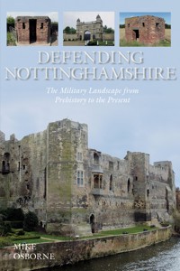
Nottinghamshire's position at the very heart of England has given it important strategic significance throughout two millennia, underlined by the number of roads, waterways, and later railways, criss-crossing the county. An endless succession of armies have used the Great North Road: the Romans, the Vikings, the Normans, the Lancastrians and the Jacobites. Strategic river crossings and road junctions have been guarded by Roman camps, Viking and Saxon burhs, medieval castles, Parliamentarian and Royalist forts, and the anti-invasion defences of the Second World War. The area has traditionally provided a rallying point for armies to be gathered, from Richard III's in 1485 to Kitchener's in 1914. Building on the experience of the great training camps of Clipstone and the Dukeries and the extensive munitions works of Chilwell and Nottingham, in the Second World War the county expanded such provision, becoming home to a concentration of flying training centres, key components of the army's and the RAF's logistical support networks and further munitions plants. Much of this military activity has left its mark on the landscape, some of it relatively untouched, and some adapted to meet the demands of change. Some monuments are of enormous national importance; Newark-on-Trent, as well as retaining its unspoilt medieval castle ruins, boasts the best single concentration of Civil War-period fortifications anywhere in Britain.
Sie lesen das E-Book in den Legimi-Apps auf:
Seitenzahl: 335
Veröffentlichungsjahr: 2014
Das E-Book (TTS) können Sie hören im Abo „Legimi Premium” in Legimi-Apps auf:
Ähnliche


To David Sibley, one of life’s true gentlemen, who contributed so much to recording the built environment.
Acknowledgements
Thanks are due to the following:
Colin Alexander; Hilary and Richard Allton; Adrian Armishaw; Peter Allen and Alistair MacIntosh for information on Margidunum used by Margaret Sibley; Bassetlaw Museum; Steve Cox; David Flintham particularly for information on Hawton redoubt; Paul Francis; Bob Holland; Pauline Marples of Forest Town; Adrian Peters; Stewart Squires; Mike Suttill of the East Midlands RFCA; Judith Wright of the archive department at Boots; Margaret Sibley; Carol Wilkinson and Bowbridge Primary School; the staff at Burton Joyce, Newark and Nottingham libraries and at the archive collections of Nottinghamshire and the University of Nottingham; and, as ever, to my wife, Pam, for constant help and support, especially through the irrationalities of a digital world.
All illustrations are the author’s unless otherwise credited.
Contents
Title
Dedication
Acknowledgements
Abbreviations
Introduction
One
Prehistoric, Roman and Saxon Nottinghamshire
Two
Fortifications in the Earlier Medieval Period 1066–1300
Three
The Later Medieval and Tudor Periods 1300–1600
Four
Stuart and Hanoverian Nottinghamshire 1600–1815
Five
Nottinghamshire in the Victorian Period 1815–1914
Six
Nottinghamshire in the First World War
Seven
Nottinghamshire 1918–39
Eight
Nottinghamshire in the Second World War
Nine
The Cold War and Beyond
Appendix 1
Prehistoric Camps
Appendix 2
Castles, Fortified Manors and Moated Sites
Appendix 3
Civil War Fortifications
Appendix 4
Army Barracks, Camps, Depots and Ranges
Appendix 5
Rifle Volunteer, Yeomanry, Militia, Territorial Force, Territorial Army and RAuxAF Drill Halls
Appendix 6
Locations Used by the Nottinghamshire Home Guard
Appendix 7
Aviation-related Sites
Appendix 8
Air Defence
Appendix 9
Prisoner-of-War Camps
Appendix 10
Military Hospitals
Appendix 11
Munitions Factories and Depots
Bibliography
Copyright
Abbreviations
NB In several places, especially where RAF buildings are concerned, reference is often made to Drawing Numbers. These consist of a sequential number and a year: thus 343/43 refers to the Watch Office for All Commands, built to the 343rd design to come out of the Air Ministry drawing office in 1943. The term ‘tb’ refers to buildings with walls a single brick in width and officially known as ‘temporary brick’.
Introduction
Nottinghamshire’s position in the very heart of England has given it important strategic significance throughout two millennia. This is underlined by the number of roads, waterways, and later, railways criss-crossing the county – the Roman Fosse Way from Exeter to Lincoln via Newark; the Great North Road from London to Newcastle through Newark, Tuxford and East Retford; the River Trent and its associated canal network connecting Birmingham and the Black Country to the east coast; the central place of Nottingham as a nodal point on the routes connecting all the main cities of the Midlands; and two of the main north-south railway lines. An endless succession of armies has used the Great North Road: the Romans of Aulus Plautius, the Vikings of Ivar the Boneless, the Normans of William the Conqueror, the Lancastrians of Henry VI’s queen, and the Jacobites of the Young Pretender. Strategic river crossings and road junctions have been guarded by Roman camps, Viking and Saxon burhs, medieval castles, Parliamentarian and Royalist forts, and the anti-invasion defences of the Second World War. The area has traditionally provided a rallying point for armies to be gathered, from Richard III’s in 1485 to Kitchener’s in 1914. Building on the experience of the great training camps of Clipstone and the Dukeries and the extensive munitions works of Chilwell and Nottingham, in the Second World War the county expanded such provision becoming home to a concentration of flying training centres, key components of the army’s and the RAF’s logistical support networks and further munitions plants.
Much of this military activity has left its mark on the landscape, some of it relatively untouched, and some adapted to meet the demands of change. Whilst the castles of Nottingham and Newark retained their defensive capabilities into the 1600s, Greasley Castle, licensed in 1340 had, by the end of the century, become a focus for industrial and agricultural activity. Built in 1792 and operational into the middle of the next century, by 1861, the cavalry barracks in Nottingham’s Park was being used for public entertainments including a demonstration by Blondin, the famous tightrope walker. Mansfield’s High Oakham House was built as a barracks in 1839, was a private residence from 1854, and was hosting evacuees from Sheffield in September 1939. Some monuments are of enormous national importance. Newark-on-Trent, as well as retaining its unspoilt medieval castle ruins, boasts the best single concentration of Civil War-period fortifications anywhere in Britain. Sadly, many undervalued monuments, particularly those on brown-field sites ripe for development, are fast disappearing. It can only be a matter of time before the watch office at Wigsley, for instance, recently denied statutory protection, disappears. Nevertheless, it is still possible to rediscover some which have been hidden. Any readers who might be lucky enough to uncover items of interest, are asked to observe three principles: to respect private property and privacy; to take appropriate care in potentially hazardous locations; and to report discoveries to local authority Historic Environment Officers or museum staff.
Nottinghamshire is a historical goldmine, often under-appreciated, and under-explored. This book is an attempt to shine some light on one particular aspect of this heritage.
Mike Osborne,2014
one
Prehistoric, Roman and Saxon Nottinghamshire
Prehistoric fortifications in Nottinghamshire
Only scanty evidence survives of early settlement in the county. Bronze Age finds at Clifton may indicate a riverside settlement. A large number of oak stakes, spaced in the riverbed a yard apart, suggest that they may have served as piles to carry a platform structure, maybe for dwellings. Although weapons were also found, these may simply constitute evidence for a site where precious possessions were cast into the river as sacrificial offerings. Even flimsier evidence of a similar nature has been turned up in Attenborough and Holme Pierrepont where three dug-out canoes were found.
There are few signs pointing to Nottingham as a fortified site in the Iron Age, but some ditches, apparently dating from this period, may be interpreted as delineating enclosures. Much of the settlement in the Trent valley consisted of a quite dense concentration of discrete farmsteads, and whilst many of these were surrounded by banks and ditches, their main purpose would have been to keep domestic animals in, and wild ones out.
There are, though, a number of sites in Nottinghamshire which have previously been classed as Iron Age hill forts. Not only is there still confusion as to the purpose of these monuments generally: permanently inhabited settlements; refuges in times of danger; sites for social or ritual gatherings; or secure stores for stock or surpluses; but doubt has actually been cast on whether they deserve the classification at all. However, one factor common to all of them is the presence of defensive features. According to Mike Bishop’s Archaeological Resource Assessment for an East Midlands Research Agenda in 2001, most of those sites designated as Iron Age hill forts may be neither Iron Age, nor hill forts. Nevertheless, there are a number of sites in Nottinghamshire which exhibit many of the characteristics of the class, usually taking the form of an enclosure with one or more banks, likely topped by wooden palisades, and fronted with one or more ditches. Such banks could be quite complex structures with timber or stone revetments, and earthen ramparts strengthened internally with stone, timber or clay. The palisade might be topped with a fighting-platform carried on a framework of timber poles, embedded in the bank, and there was the possibility for towers, at intervals along the ramparts, or spanning gateways. Ditches were deep, and often wet, set in marshy ground, or fed by a stream. Entrances could be quite complex structures, often set in re-entrants with banks overlapping to create killing-grounds in the dog-legged passageways between inner and outer gates.
Whilst some of the county’s putative hill forts, such as Beacon Hill Camp at Gringley-on-the-Hill, for instance, are set in dominant positions in the landscape, there is none which can claim to be anything approaching the impregnable fortresses of the South Downs. Arnold’s Cockpit Hill has double ditches, and Fox Wood at Woodborough, where the farmer, Grahame Watson, has reconstructed an Iron Age round-house, has two circuits of ramparts and ditches, but most, such as Scratta Wood at Shireoaks, Crow Wood, Styrrup, or Burton Lodge, all three of whose perimeter defences have been excavated, had only a single layer of defences. The camp at Combs Farm, Farnsfield, presents as a promontory fort, with its neck defended by a ditch. Probably the most impressive is Oxton, or Oldox (Old Works) Camp on Robin Hood Hill, a few miles west of Southwell. Covering 3 acres (1.2ha), it is univallate on the west but has triple banks and ditches on, what may have appeared as, the more vulnerable south-east. There were two entrances, on the north-west and the south-east, and a 20ft (6m) high barrow outside the camp. Although appearing from the north-western approach to be occupying a dominant position on the end of a steep-sided ridge, and enjoying panoramic views of the surrounding landscape, the camp actually lies in a dip, and can be overlooked from neighbouring high ground on three sides, seriously compromising its defensive value. Two further sites, that at Dorket Head near Arnold, and the apparent Roman fort found at Broxstowe in the 1930s have also generated discussion over their origins and status, possibly having earlier Iron Age histories followed by later Roman occupation.
1 Gringley-on-the-Hill, an Iron Age camp in a dominant position overlooking a wide swathe of countryside.
2 Oxton, Robin Hood Hill, an Iron Age camp occupying a prominent but vulnerable position.
Whatever the purpose or uses of these sites, they may be thought of as settlements which were built by people for whom some feeling of security mattered. The tribal area of the Corieltauvi took in Nottinghamshire and its neighbouring counties, but the major tribal centres were elsewhere: Leicester, Old Sleaford, Burrough Hill near Melton Mowbray, and Lincoln, and it would appear that there were no important tribal or clan strongholds within the county. It may be that the Romano-British settlement at Dunston’s Clump, west of Retford, consisting of a series of rectilinear timber-framed buildings of the first and second centuries AD, surrounded by a substantial ditch, represented a continuation into a new era, of what had become the area’s typical homestead.
Roman fortifications in Nottinghamshire
Shortly after the Romans’ second excursion into Britain in AD43, Aulus Plautius established a frontier, marked by the Fosse Way. This made use of the limestone escarpment and the rivers Avon, lower Severn and Trent, reputedly used as a prehistoric trackway known as the Jurassic Way. Once this line had become established, those tribes to its east were disarmed. The Fosse Way itself ran all the way from the Exe estuary in Devon, to Ilchester (Somerset) before heading in a north-easterly direction through Cirencester (Gloucestershire), Leicester, itself a possible Legionary fortress under Plautius, and on to Lincoln.
The Roman army constructed several types of fort to fulfil particular roles. Whilst their general shape and layout generally conformed to a uniform design, the size of each fort was dependent on the number of troops expected to be based in it. The most common shape for the majority of Roman forts was rectangular with rounded corners, resembling a playing card. An outer ditch was dug whose spoil formed an inner bank, surmounted by a timber palisade. Permanent forts could have quite sophisticated defences with earth or clay banks and timber, or even stone, walls with towers and gates. Timber towers would project internally within the rounded corners and, if the fort were sufficiently large, more towers would straddle the fighting platform along the tops of the walls. The forts were laid out on a grid pattern with roads connecting the four gates, centrally placed in each wall. In the centre was the house of the commandant with a strongroom. Barrack-huts, granary, stores, baths, stables and workshops occupied the blocks formed by the roadways. In large forts, a track, the pomerium, ran around the inside of the walls to permit the speedy reinforcement of threatened lengths of wall in the event of an attack. Often a civilian settlement, a vicus grew up outside the gates of a fort, providing goods and services for the troops, ranging from pottery and metalwork, to food, and rest and recreation.
Roman forts
Vexillation fortresses, covering an area of around 20-30 acres (8-12 has), were built to accommodate mixed forces of legionaries, cavalry and auxiliaries, numbering up to a couple of thousand men, tasked with the operation to disarm the tribes during the early stages of the Roman Conquest of Britain. Two such forts, possibly used as bases for elements of the Ninth Legion, are known in Nottinghamshire. Osmanthorpe is one, and the other is Broxstowe. This latter fort, now lying under housing, was excavated in the 1930s. It had been constructed between AD50 and 60 as a base for expeditions to subdue the Brigantes of Cheshire and North Wales. Second and third phases lasted until AD75. It is unusually shaped with a cut-off corner causing it to resemble a Welsh harp. A combination of this odd shape and some ambiguous finds have caused its origins to be questioned, and it may be a re-used site from pre-Roman times.
Forts were built along the Fosse Way for garrisons to secure the temporary frontier and the lines of communication, particularly river-crossings, and many of these were later to develop into civil settlements. A fort at Tillbridge Lane, Newton-on-Trent, on a cliff on the Lincolnshire side of the river, dates from the campaigns of the AD40s and 50s, and guards the road linking Worksop and Lincoln as it crosses the Trent. A little to the north, on the west bank of the Trent, a fort at Littleborough (Segelocum), was built to house auxiliary troops. It was occupied during the first century AD, to guard a ford across the Trent on the Lincoln to Doncaster road, which branches off from Ermine Street just below Scampton. A corresponding earthwork has been reported on the eastern, Lincolnshire bank at Marton. A similar auxiliary fort, fulfilling the same role, once lay beside the River Don at Templeborough (Yorkshire), on the Roman road from Nottingham to Doncaster. Guarding the Fosse Way itself there were at least two early forts and a possible third one. At Margidunum, just to the north of Bingham, a fort may have been built by AD50. Excavation has uncovered the stone foundations of the commandant’s house, arranged around a courtyard with verandas and covered ways, and replacing an earlier timber version. There are indications that the fort had a large military supply base alongside, apparently evidenced by large quantities of slag associated with iron-working. However, it has been suggested that such a depot might not have been risked in, what was at that time, the front line, that a military presence existed only until the troops moved on sometime around AD70, and that some of the industrial activity belonged to the later phase of the site. At Brough (Crococolana), a ditched enclosure to the north-east of Newark, the cheek-piece of a Roman cavalry helmet with a casting of Epona, the Celtic goddess of horses, has been found. Notwithstanding the isolated and circumstantial nature of this evidence, it could still point to an occupation by auxiliary cavalry. Thorpe (Ad Pontem), the likely site of a pontoon bridge across the Trent, lies south of Newark. Here it appears that a fort with a large annexe on its northern side was built around AD50–75, the first in a sequence of four building phases. From a much later period, but still a time when it was imperative that important routes be safeguarded, comes a small rectangular, triple-ditched enclosure at Scaftforth, east of Bawtry Bridge by the River Idle. Finds point to this being from the late Roman period. Attempts are often made to infer from the Roman road layout and known forts the likely locations of further forts in the network. Postulated forts in the area here under consideration include one near Bardon (Leicestershire), a second near Bilsthorpe, and a third near Radcliffe on Trent. It has been suggested that there was a possible Roman bridge over the Trent at Cromwell.
The final category of Roman fort represented in the county is the marching camp, a temporary overnight stop rather than a permanent garrison, with the purpose of simply providing security against a surprise night attack. On the march, Roman legionaries each carried a sharpened stake which would be used to supplement the 6ft (1.8m) high bank and the 5ft (1.5m) deep ditch, carefully constructed at the end of the day’s march. Five examples of these marching camps are known in Nottinghamshire: at Farnsfield, Gleadthorpe near Warsop, Holme north of Newark on the bank of the Trent, and two at Calverton, one within the other but on a slightly different alignment.
Roman defended settlements
Some of these early forts went on to be developed as civil settlements. It would appear that the military had moved on from Margidunum well before the end of the second century, and that industrial activity either continued from these earlier days, or started up subsequently. With the demise of the fort came a small, walled town of 5 acres (2 has) on a different alignment from the fort. By the fourth century it had become more of an official staging-post on the Fosse Way rather than a civil settlement, and by 500 it was deserted. The town straddled the road and was enclosed, towards the end of the second century, by a wide defensive ditch and, initially, an earthen bank, polygonal in shape consisting of six fairly straight stretches forming an irregular hexagon. A century later significant improvements were made to these defences when the earth bank was enlarged, and a stone wall built into its forward face. In similar towns at this time this arrangement is known to have provided a stable fighting-platform, often of sufficient depth to carry defensive artillery such as heavy, bolt-firing crossbows and stone-throwing catapults. New outer ditches with an outer bank were also constructed and there were gates where the main road entered and exited the town in the north-east and south-west. Stone buildings stood both inside and outside the walled area. Like Margidunum, Ad Pontem was given its first defences as a non-military settlement towards the end of the second century. These consisted of a clay rampart with outer ditches on the lip of a terrace above the river, and a possible gateway may have provided access to the river-bank. Four circuits of widely spaced ditches suggest that the enclosed area was successively enlarged. Early in the third century a stone wall with a thickness of 8ft (2.4m), backed by a massive earthen rampart was built. These walls were pierced by a gateway, consisting of a timber-framed tower, and were continuously refurbished over the next two centuries. The settlement of Willoughby-on-the-Wolds (Vernemetum), on the other hand, remained an undefended roadside settlement, but continued in use into the Anglo-Saxon period.
3Margidunum, a reconstruction by Margaret Sibley, using all the available information; it shows the walled town straddling the Foss Way.
Anglo-Saxon and Danish fortifications
There is evidence that a handful of Roman sites continued in occupation after the Romans had left around 410. The towns of Margidunum, Vernemetum and Crococalana have all yielded up Anglo-Saxon finds as has a villa site in Southwell. Whilst evidence of Saxon occupation at Newark-upon-Trent has led to speculation regarding the dating of the defensive bank and ditch surrounding the core of the medieval town, it is now known that these defences were raised shortly after 1066 along with the castle in its very earliest form. The Battle of Heathfield in 633 had seen King Edwin of Northumbria defeated and killed by the pagan king Penda of Mercia and when, in the 1950s, excavations beneath nearby Cuckney church, standing within the Norman castle earthworks, revealed up to 200 skeletons in mass-burial trenches, there was speculation that these might represent casualties from the battle.
Until around 865 the Danish raids on England had been hit-and-run attacks involving the gathering of loot and the destruction of property, after which the raiders would sail away to return another year. Sometimes Danish fleets over-wintered, drawing up their boats onto dry land alongside a suitable beaching-place, and surrounding their laager with a semi-circular enclosure defended by a bank and ditch. Such encampments were established at Repton (Derbyshire), and on the Lincolnshire bank of the Trent at Torksey. From this period onwards, however, the Danes showed every intention of colonising England. In 867 the Danish army had occupied York, where they defeated the Northumbrians attempting to dislodge them, and then moved south into Mercia, occupying Nottingham, where their ships could be protected. There is no real evidence of any significant earlier fortification, so a half-moon-shaped banked and ditched enclosure backing onto the Trent, and harbouring the Danish fleet, probably represented the first attempt to fortify this site. Its strategic significance lay in the strength of the high ground overlooking the Trent, and its status as the lowest point at which the river might easily be forded. Additionally, it commanded the Great North Road as well as the river. The Danish army, led by Ivar the Boneless and Halfdan Ragnarsson, was opposed by Burghred, King of Mercia, who, in 868, assembled a large army and invested the Danish fort. To maintain a full blockade, more troops were needed and so an approach was made to Wessex. Alfred and his brother Aethelred raised a large force of levies from Wessex and marched on Nottingham. However, the Danish defences were too strong and their warriors better armed and trained, and a truce was soon declared, after which the men of Wessex were grateful to head back home. It is possible that this early experience of having to compromise with a securely ensconced enemy determined Alfred in his future quest for victory on the open battlefield. Following a decade of often inconclusive warfare, Guthrum, the Danish leader, settled for peace and a share of the land, and the ensuing treaty partitioned England, setting up the Danelaw, to the north and east of a line drawn from Cheshire down to a point on the Thames, east of London.
Nottingham was soon established as an important Danish settlement beginning as an industrial centre with pottery kilns eventually producing a distinctive splashed ware, examples of which were found in a ditch filled in after 1066. However, the settlement was probably not fully fortified until around 900, possibly following the example of Alfred’s Saxon burhs. Representing one of five separate jarldoms under the Kingdom of York, it became one of the Five Boroughs, along with Derby, Stamford, Lincoln and Leicester, and a centre of trade with Scandinavia and the Low Countries. Whereas Derby, Lincoln and Leicester had all previously been fortified by the Romans, there is only slight evidence that Stamford and Nottingham had been occupied to any great extent in the Middle Saxon period at all. At Nottingham the Danish stronghold was surrounded by a bank and ditch, 19ft 6in (6m) wide, and 11ft (3.5m) deep with a U-shaped profile, later re-cut to become V-shaped. All this pre-dated the works of Edward the Elder. Traces of this early ditch were found near to Fletcher Gate (at SK574396), and bow-sided timber buildings, up to 100ft (35m) in length and usually described as halls, have been excavated near St Mary’s church. These were similar to structures found in other Viking settlements in the east Midlands and were once wrongly thought to have derived from up-turned boats.
As part of his drive to reintegrate the Danelaw into a kingdom which comprised Wessex and Mercia, Edward the Elder captured Nottingham in 918, and organised a rebuilding of the town’s defences, to be manned by both Mercian and Danish troops together. Two years later Edward returned and supervised the construction of a new burh, south of the river and linked to the existing one by a bridge, a very similar procedure to that he had carried out in Stamford. Nottingham’s bridge, called the Hethbethebrigg in 920, would be rebuilt many times over the centuries, its final embodiment being demolished after 1871. A number of these ‘double-boroughs’ had been constructed on the Continent by Charles the Bald in the mid-ninth century, and there was an example at London, where Southwark represented a discrete burh on the south bank of the Thames. The establishment of these strongholds was part of a deliberate strategy by Edward, which involved the construction of some twenty-eight such fortresses, so sited as to deny the Danes the possibility of carrying out deep penetration raids into the heart of Mercia and Wessex, by blocking the river routes traditionally used by their longships.
There is no suggestion that Danish Nottingham represented a fully developed urban settlement but it did form the basis for a Saxon town after 920. Around St Mary’s church, which may have been built as a Saxon minster, two of whose arches from the twelfth-century rebuild survive, there was a new Saxon enclosure. This was defended by a bank and ditch, and development on Barker Gate and Pilcher Gate exposed these Saxon defences in 1966. The area enclosed by Edward’s defences is reckoned to have been 39 acres (15.5 has). The Wessex system of burhs was driven by an assessment of the land necessary to produce an adequate garrison for the local fortress. It has been suggested that Nottingham could draw manpower from around 1,300 hides which, applying the formula from Alfred’s Burghal Hidage, would support a defended perimeter of about 1,500 yards, and the defences of what would become Nottingham’s English Borough do indeed extend to a little under 2,000 yards, making these figures supportable. The town appears to have been dominant in the control of Edward’s northern frontier, spreading its influence into Derbyshire. Throughout much of the tenth century, the mixed population of the Danelaw maintained a militia which effectively withstood attack from the north.
In 941 the Five Boroughs were taken back into the kingdom of York by King Olaf, and it is possible that a refurbishment of the earlier defences may date from then. In 1013 they submitted to Swein Forkbeard who was in the process of conquering England. By 1016, following the completion of the Danish conquest, Cnut created a new earldom. However, following unrest over newly introduced taxation under Earl Tosti of Northumbria and consequent representations to King Edward the Confessor, it was subsumed, after 1041, into the earldom of Mercia under Leofric. At the time of the Norman invasion, Nottingham was still confined to the eastern part with no evidence of any settlement on what would become the site chosen for new defences.
4 Carlton-in-Lindrick, an eleventh-century Saxon church tower.
Anglo-Saxon church towers are thought to have played a part in secular as well as religious display, both as potentially defensive places of refuge, or as symbols of local authority where the local landowner might appear before his people, perhaps prior to dispensing justice. The word ‘belfry’ derives from words meaning height and strength. The west tower of St John the Evangelist at Carlton-in-Lindrick dates from the eleventh century and was added to an existing nave. It was originally of three stages with coupled bell-openings on two sides. The fourth storey was added after 1417. The ground floor of St Peter’s, Clayworth, is also Saxon, and another, St Peter’s, at Flawford, Ruddington, was demolished in 1773, but excavations have shown that a west tower had been added to the earlier church, in common with many other such towers, in later Saxon times.
Nottinghamshire exhibits a wide variety of features drawn from both Saxon and Danish cultures. There are Saxon place names such as Plumtree, Cuckney or Worksop, alongside Danish names which include Stragglethorpe, Welbeck and Kirkby. The moot known as the Thynghowe near Birklands, which was a place for applying the rules of the Danelaw, could not have been given a more Danish name, but it stands deep in Sherwood (Saxon: Shire Wood) Royal Forest. This may demonstrate how well-populated areas still absorbed incomers with their new customs and their new place names.
two
Fortifications in the Earlier Medieval Period 1066-1300
The campaigns which consolidated William I’s conquest of England brought major changes to both the urban and the rural landscape. Although there had been examples of private fortifications in pre-Conquest times, the decades immediately following saw an explosion in castle-building with Nottingham as one of the earliest examples. As land was parcelled out to the new Norman nobility, castles were built as centres of these new estates and to epitomise the incoming regime. A century later, the Anarchy brought forth a further crop of castles, whilst general insecurity subsequently encouraged those with something to protect to build defensible residences.
Early Norman earth and timber castles
Very few castles share more than a superficial similarity. Although the received wisdom of the last 100 years stresses that the Normans built motte and bailey castles, the reality is much more complex. Although the castle, as a fortified private residence or a fortified centre of royal power was, indeed, a predominantly novel importation by the Normans, there were some existing precedents in England. A handful of castles had been built in the years preceding the Conquest by Normans resident in England under the patronage of Edward the Confessor. There were also some private fortified houses built by Saxon thegns, probably consisting of a timber hall and ancillary structures surrounded by a bank and ditch with a timber palisade and, perhaps, a gateway with a platform over it. This structure might be associated with an adjacent church with a stone tower. With the exception of a very small number, the Normans’ early castles were built of earth and timber. In its simplest form, the castle consisted of a circular bank and ditch defended by a palisade, pierced by a defended gateway. Within this defended perimeter there might be a timber hall, stables, barns and workshops, and a chapel, space enough to accommodate the lordly family, the household servants, and half-a-dozen men who worked the land but, appropriately trained and equipped, could fight for their lord when called upon. This form of castle is known as a ring-work, which might have had an additional, outer enclosure, or bailey, differing little from the thegnly establishment it might have superseded, probably being only somewhat stronger. The motte was either a wholly artificial mound of earth, formed with the spoil from its deep surrounding ditch, or else a modification of an existing natural hillock or crag enhanced by scarping to make the sides steeper and more uniform, and isolated by the digging of a ditch. Either form could receive additional benefit from its natural surroundings – steep slopes or marshes for instance. It was sometimes necessary to strengthen the motte by layering it with timber, encasing it in clay, or terracing it and using stone revetments. Such techniques were most likely to be employed when the motte was intended to carry a heavy stone tower, but timber towers were often mounted on posts which were bedded on solid ground within the mound, and stone towers could be built on a foundation level or basement embedded in the mound itself. Much depended on the local geology and the nature of the soil. The motte-top might have a timber palisade with a fighting platform around the rim. If there was enough space, this shell-wall might have timber lean-to pentices built against it, forming a central courtyard, with or without a tower in its centre. Since mottes were less roomy than ring-works, they almost invariably had one or more baileys containing the structures which met the residential requirements of the household and garrison. Each bailey would be surrounded by bank, ditch and palisade, and have its own gateway. Often the inner bailey would be crescent-shaped, wrapping itself around the base of the motte, thereby maximising the defensive firepower of archers on the motte, whilst at the same time keeping attackers from approaching too closely to the base of the motte. Access to the motte would be by a flying bridge, by steps cut into the motte’s side, or by continuing the bailey wall up the side of the motte to join the shell-wall, perhaps even with a tower at the junction. Some mottes had complex entry arrangements with gates and outer barbicans. Sometimes the choice of what type of castle to build was determined by the site, but other factors including purpose also came into play. The higher, more imposing, motte could be chosen as a means of overawing a subject population, for instance, in urban or rural setting. Choice could come down to local fashion or personal whim. Early attempts to quantify earthwork castle types in Nottinghamshire came up with a low ratio of ring-works to mottes, but more recent reinterpretations of sites and the application of improved criteria for the definition of castle-sites produce a figure closer to the national average.
Nottinghamshire’s early Norman castles provide some good examples of many of the features described above. At Laxton a motte and bailey layout was adopted. The motte was large enough to have an imposing structure on top, providing a powerful message to the people of the forests whose administrative centre it soon became. The inner bailey was walled in stone and there has been speculation over the nature of the motte’s crowning glory. In an article on computer games and virtual landscapes (Vista Centre in the Institute of Archaeology and Antiquity, University of Birmingham), Laxton was the recent subject of an investigation using cartographic, topographic and geophysical evidence, on the basis of which, hypothetical reconstructions were based. These are described as ‘plausible’ and reflect the arrangement of the earthworks and surviving fragments of masonry. A number of possible toppings for the motte were suggested, ranging from a shell keep à la Totnes (Devon), to a copy of St Leonard’s Tower at West Malling (Kent) and to York’s quatrefoil Cliffords Tower. Realistically the motte is unlikely to have supported the mass of masonry associated with towers, but a shell-keep is more feasible. The small mound which currently stands in the middle of Laxton’s motte-top is thought to be a garden feature from several centuries later. The castle was ruinous by the late 1300s but a manor house occupied the inner bailey in Tudor times. The motte-top at Bothamsall has a sunken middle, quite large enough to hold a hall and detached kitchen. Prior to the Conquest it had been held by King Harold’s brother Tostig, several of whose other estates acquired castles shortly after 1066. This begs the question as to whether these were developments of Tostig’s own private fortified dwellings. If so, then Bothamsall may fall into this category, a hybrid motte/ring-work. The large motte at Egmanton appears to have a terrace to one side, and an appealing explanation for this is that it was a barbican, defending the entrance into the core defences on the motte-top. The connection between church and manor in Anglo-Saxon times has already been noted, and it would appear that this connection was to be continued under the Normans. Here at Egmanton the motte, with what appears to have been a wrap-around bailey, is built very close to the church. At Cuckney, whose motte is revetted in stone, the castle is likely to have been built around an existing church. At Southwell, the church itself became a castle for a short while. The proximity to the church at Shelford of a small, horseshoe-shaped earthwork may suggest a further example of this relationship of church to castle.
At Newark the stone castle of Alexander, Bishop of Lincoln was preceded by an earthwork castle soon after the Conquest. It is possible that this took the form of a motte and bailey, whose motte occupied the north-west angle between the present river-front and the approach to the bridge over the Trent. It would have been razed when the new gatehouse and angle tower were built in 1130


