13,99 €
Mehr erfahren.
- Herausgeber: The History Press
- Kategorie: Sachliteratur, Reportagen, Biografien
- Sprache: Englisch
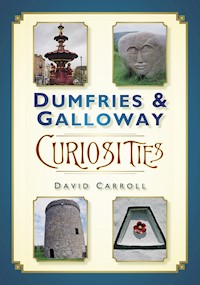
Along with its rich history and spectacular scenery, Dumfries and Galloway is home to a great many curious and unusual buildings, objects and landscape features that have survived the centuries. This well-illustrated book is a guide to 100 of these remarkable sights, including Scotland's highest village, the world's narrowest hotel, and even the statue of a rhinoceros on top of a bus shelter. Dumfries & Galloway Curiosities will encourage readers to explore this area of south-west Scotland and perhaps make their own curious discoveries.
Das E-Book können Sie in Legimi-Apps oder einer beliebigen App lesen, die das folgende Format unterstützen:
Veröffentlichungsjahr: 2013
Ähnliche


For Toby, Maisie and Amber,
and in memory of Max.
Contents
Title Page
Dedication
Acknowledgements
Introduction
1. Landscape Features
2. Churchyard and Other Memorials
3. Buildings and Structures
4. Objects and Artefacts
5. A Curious Miscellany
Bibliography
Copyright
ACKNOWLEDGEMENTS
I am grateful to the following people for their help during the preparation of this book: Bernadette Walsh, for technical support above and beyond the call of duty; Bill Lawson, for information regarding Cruck Cottage, Torthorwald; Alverie Weighill, for suggesting several of the subjects included here; the staff of Dumfries Museum; the staff of the Stewartry Museum and the Tolbooth Art Centre, Kirkcudbright; the staff of the ‘Devil’s Porridge’ exhibition, Eastriggs.
I am also grateful to Lorna Adams, Angela Cameron, Evelyn Kelly, Marie McIntosh, Babette Pattinson, Moira Priestley and Pam Purdie for their helpful suggestions. For my understanding and explanation of the charcoal-making process (see ‘Carstramon Wood’), I am indebted to Lyn Armstrong’s informative book, Woodcolliers and Charcoal-Burning. The Belted Galloway Association’s website also proved invaluable for background information regarding ‘Belties’. For permission to use an extract from Five Red Herrings by Dorothy L. Sayers, I am grateful to David Higham Associates.
Every reasonable effort has been made to trace the holders of copyright material. Any omissions are regretted and will be rectified, upon notification, in any future edition of this work. Finally, all the photographs that appear in this book were taken by and are the copyright of the author.
INTRODUCTION
The area covered by Dumfries and Galloway is a large one (in fact, it runs to almost 2,500 square miles). However, it wasn’t until I began researching this book, repeatedly driving the length and breadth of the region in search of some of its more unusual aspects, that I realised just how extensive it is.
Dumfries and Galloway comprises the separate counties of Wigtownshire and Kirkcudbrightshire (historically Galloway), together with Dumfriesshire. There are few towns of any great size, the most notable of which is the region’s administrative centre, Dumfries. Given the sparsely-inhabited tracts of mountains, moorlands and forests contained within its boundaries, it is not surprising that the population of Dumfries and Galloway is low (the figure is around 150,000, making an average of sixty people per square mile). What is more unexpected, perhaps, is the abundance and variety of ‘curiosities’ that Dumfries and Galloway can offer. There are unusual landscape features such as the Motte of Urr and the Devil’s Beef Tub, together with distinctive buildings including Orchardton Tower and also the Cable House near Portpatrick. A wartime pillbox at Heathhall and a Mulberry Harbour off the coast at Garlieston, not forgetting our distant ancestors’ endeavours in creating the Torhouse Stone Circle and the burial chambers at Cairnholy, are among the many interesting discoveries that the reader will make in these pages.
Dumfries and Galloway is also remarkable for its range of truly unique features, including Wanlockhead, which is Scotland’s highest village, and the Mull of Galloway, which is Scotland’s most southerly point. The town of Dumfries is home to Scotland’s oldest working theatre, and Balmaclellan churchyard is the site of the country’s first civic war memorial. Furthermore, Sanquhar can boast the world’s oldest working post office, and Eskdalemuir has witnessed the development of the Western world’s first major Tibetan centre. At Moffat, you can savour the experience of staying in the narrowest hotel in the world.
This book is designed to be ‘dipped into’ rather than being read as a continuous narrative. However, in order to give it some form, the items in each individual section are arranged – as far as possible – from east to west across the region, although, in a few unavoidable cases there are slight variations to this scheme.
I have made every effort to establish the accuracy of the information contained in this book, and I apologise for any unintentional errors. Where information on a specific topic has varied from one source to another, I have tried to draw upon what I have judged to be the most reliable reference in each case. Finally, wherever ‘DGNHAS Transactions’ appears in the text, this refers to the Dumfriesshire and Galloway Natural History and Antiquarian Society.
David Carroll, 2013
1
Landscape Features
THE SCOTS’ DIKE
A PART OF THE BORDER BETWEEN ENGLAND AND SCOTLAND
Today, any attempt to walk the three-and-a-half miles of the Scots’ Dike (occasionally spelt dyke), is almost certain to end in frustration and failure. This sixteenth-century linear earthwork that forms a part of the border between England and Scotland, stretching east to west from the River Esk to the River Sark, is hidden and obscured by dense coniferous and mixed woodland, which runs along its entire length. However, should anyone persist in traversing this boundary, they may garner some scratches and possibly even a sprained ankle along the journey, as they slowly pick their way through a maze of low branches and the tangled undergrowth.
The Scots’ Dike, which was actually built by both the Scots and the English in a joint venture, was constructed in 1552. Its purpose was to resolve the continuing disputes that had erupted between England and Scotland over the so-called ‘Debatable Lands’. This was an area running south to north (and almost four miles wide) from the Esk estuary to Tarras Moss, north of Canonbie, and the ownership of which was not clearly established. The Scots’ Dike was the means by which this land was carved up between the two separate kingdoms.
Given its historical significance and national importance, it is unfortunate that so little remains to be clearly seen ‘on the ground’ of the Scots’ Dike. It has been suggested that, originally, there was a stone positioned at each end of the earthwork, one bearing the royal arms of England and the other bearing those of Scotland; if that were the case, these ‘terminal stones’, as they were described, have long since disappeared. However, an old un-inscribed boundary stone – one of a number that once marked the earthwork’s course – can be found at the eastern end of the Scots’ Dike, about two miles south of Canonbie.
A modern boundary stone at the eastern end of the Scots’ Dike.
A modern drainage trench and earthen banks which follow the course of the Scots’ Dike.
BURNSWARK HILL
ONCE THE HAUNT OF ROMANS AND MALEVOLENT FAIRIES
The large flat-topped hill called Burnswark, which lies about four miles south-east of Lockerbie, is one of Annandale’s most distinctive landscape features and can be seen for miles around. Approximately 940 feet high, it is a familiar landmark for motorists travelling on the M74 and for passengers on the adjacent main west coast railway line. The course of a Roman road skirts the bottom of Burnswark to the south-west, and the hill boasts two Roman camps, together with evidence of earlier occupation dating from the Bronze Age. As a result, it has long been of interest to archaeologists and antiquarians alike.
John Maxwell Wood, in his Witchcraft and Superstitious Record in the South Western District of Scotland (1911), observed that:
In Annandale, the great fairy strength and palace lay in the heart of Burnswark Hill. The reputation of these Annandale fairies seems to have been rather disposed towards evil than good. Young men as well as young women were carried off, the former to act as slaves and beasts of burden.
In his story Elphin Irving: The Fairies’ Cupbearer (1822), Allan Cunningham mentions how the fairies were eventually expelled from the place by ‘Donald Cargil, the Cameronian, [who] conjured them into the Solway for playing on their pipes during one of his nocturnal preachings on the hip of Burnswark Hill.’
A view of Burnswark from the outskirts of Lockerbie.
Long after the Romans had left these shores, Burnswark may have been the scene of a great battle that took place in 937, known as the Battle of Brunanburh, when the English army, led by Athelstan and Edmund, was pitted against the might of the Kingdoms of Dublin, Alba and Strathclyde. A poem in the Anglo-Saxon Chronicle recounts the battle, the actual site of which is still hotly debated by scholars. Many different possible locations have been suggested over the years, but Burnswark certainly remains one of the more persistent candidates.
LOCHMABEN OLD CASTLE
GOLF COURSE’S LINK WITH ANCIENT FORTIFICATION
The remains of a once-impressive castle lie on the wooded banks of Castle Loch at Lochmaben. It was built around 1300 by the English monarch Edward I (sometimes known as the ‘Hammer of the Scots’) during the Wars of Scottish Independence. As such, it was destined to change hands between the English and the Scots on several occasions over the subsequent turbulent years.
This substantial stone castle replaced an earlier fortification – a motte-and-bailey castle – dating from the mid-twelfth century, a remnant of which can be found nearby on the strip of land that separates Castle Loch and Kirk Loch. (For background information about motte-and-bailey castles see the entry on the Motte of Urr, p. 30). It was built by the Brus family, who were the Lords of Annandale and forebears of Robert the Bruce. Bruce’s grandfather is believed to have died here in 1295.
The mound of Lochmaben’s motte-and-bailey castle.
The summit plateau. Now part of Lochmaben’s golf course.
Although it lies beside a public road, from where it can be easily seen at close quarters, this ancient earthwork is not immediately apparent to the casual eye. With traces of its encircling defensive ditch still in evidence, the mound (or motte), dotted with trees and cloaked in rough grass, is denied the clarity of the classic outline, which can be seen at other motte-and-baileys elsewhere in the region – for example, the Motte of Urr, near Dalbeattie, and Druchtag Motte at Mochrum.
Given its sometimes turbulent history – the fortification was captured by Edward I at the end of the twelfth century – it is refreshing to discover that, in an interesting variation on the biblical theme of ‘beating swords into plowshares [sic]’, the motte now serves a more peaceful purpose. It has been woven into the course at Lochmaben Golf Club, with the summit plateau playing host to the immaculately clipped second green.
BROW WELL
A MINERAL SPRING WITH A SAD LITERARY CONNECTION
The once-popular chalybeate well at Brow lies inconspicuously by the roadside, about a mile south of Clarencefield and on the edge of the Solway Firth. Although dismissed by the Revd John Wilson in his 1882 Gazetteer of Scotland as a ‘decayed small watering-place’, Brow was a busy spot in former times, attracting visitors by the score; most of them seeking restoration of their health from the supposed healing properties of this sequestered mineral spring. In 1796, Robert Burns visited Brow Well during the final weeks of his life, in an attempt to regain some of his strength. He arrived on the 3rd of July and lodged near the well. William McDowall, in his book The History of Dumfries, records that ‘Brow was then a hamlet numbering about a dozen houses, the chief of which was an inn kept by a Mr Davidson, who willingly allotted the “chaumner en” of his little hostelry to Burns as a lodger’ (the inn was demolished in 1863). ‘Often, great herds of cattle going south rested for a night in the neighbouring Merse,’ McDowall continued, ‘while their drovers proved the best customers that the inn possessed.’
However, no amount of the mineral water – which he drank from an iron cup suspended by a chain from the side of the oblong-shaped well – could restore Burns’s health. He also tried the effects of bathing in the waters of the adjacent Solway, but all to no avail. There was an apparent slight improvement in his condition at the beginning of his stay, but it was not sustained. Burns went home to Dumfries on the 18th of July and died three days later. (Hundreds of people attended the ceremony that was held at Brow Well in July 1996 to mark the bicentenary of Burns’s death.)
Brow Well, where Burns tried to regain his health in the summer of 1796.
THE GREY MARE’S TAIL
‘WHITE AS A SNOWY CHARGER’S TAIL’
There are at least three Grey Mare’s Tails to be found in Dumfries & Galloway, but the highest and most famous of can be glimpsed from the A708, a few miles before the Moffat to Selkirk road skirts the shores of St Mary’s Loch. This waterfall has the secluded Loch Skeen, in the sometimes bleak Winterhope glen, as its source, and tumbles 300ft before finding its way into Moffat Water. This foaming cataract, which is as ‘white as a snowy charger’s tail’, as Sir Walter Scott memorably described it, can be viewed at close quarters from either of the two well-trodden footpaths that begin near the roadside car park. Despite their benign appearance, however, particularly after dry weather during the summer months, neither route should ever be attempted without stout footwear, nor by anyone who does not possess at least a reasonable head for heights.
The shorter of the two tracks follows an uneven course to the foot of the waterfall, but even this seemingly innocuous path is not without its hazards. Landslips and the occasional maverick boulder are not unknown; the latter dislodged by sheep grazing on the steep hillside. From here, the spectacular sight afforded by millions of gallons of water crashing down from a great height is made still more impressive by the thunderous roar of the cataract’s downward progress.
The Grey Mare’s Tail from the lower path.
In contrast to this low level walk, the route on the opposite flank of the waterfall climbs up the eastern shoulder of the Grey Mare’s Tail, eventually arriving at Loch Skeen itself. This narrow path, which is extremely steep in places, should only be attempted by more experienced walkers, even in fine weather. There are several precipitous drops en route that have been the cause of more than one fatal accident over the years, but the careful walker who keeps to the recognised path has little to fear when the going is firm and free of snow or ice. However, this taxing walk provides an ideal opportunity to not only savour the waterfall itself, but to catch a glimpse of the two distinct herds of wild goats that roam – but reputedly never mingle – on the adjacent hillsides.
The course of the Grey Mare’s Tail.
MOFFAT WELL
‘NO WATER GOES MORE PLEASANTLY DOWN’
A sulphurous well on the northern outskirts of Moffat was discovered in 1633 by Rachel Whiteford, daughter of the local clergyman at that time. Having previously ‘taken the waters’ herself in England, she was well-equipped to recognise the nature of the liquid that she found issuing from a spring, which was about a mile from the centre of this small town at the head of Annandale. Her discovery was to prove a turning point – albeit a very gradual one – in the development and character of Moffat, which up until then had been a quiet and unremarkable spot. Slowly it grew into a fashionable and popular spa resort, eventually becoming labelled as the ‘Cheltenham of Scotland’.
Thomas M. Fairfoul wrote in his guide to Moffat (Fairfoul’s Guide to Moffat, first published in 1876) that the water drawn from the well has been likened to that of ‘bilge water, of rotten eggs and of a gun newly fired.’ These graphic descriptions leave nothing to the imagination, although Fairfoul comments, somewhat charitably, that ‘the mildest of these comparisons no doubt exaggerates … in the long run there is no water goes more pleasantly down.’ The liquid itself was reputed to help with rheumatic conditions, as well as lung and skin complaints.
The small stone building that houses Moffat Well.
A small pump house was built over the spring in 1738, and at the height of the summer season a procession of visitors could be found early each morning making their way along the narrow lane which led up from the town to the well. Once they arrived at the pump house, the visitors drank their ‘statutory quantum’ of three large tumblers of water. ‘A man of moderate energies,’ declared Fairfoul, ‘may take his three tumblers without being inconvenienced, but on the contrary braced and appetised, though he should not be in any undue haste to run to his breakfast.’ The small stone building which houses the shaft of the well, and which is permeated with the unmistakable smell of sulphur, was restored to its present condition in 1986.
THE DEVIL’S BEEF TUB
‘A DEEP, BLACK, BLACKGUARD-LOOKING ABYSS OF A HOLE’
Whether it is the Devil’s Punch Bowl at Hindhead in Surrey, or the Hole of Horcum on the Pickering to Whitby road in the North Yorkshire Moors, large depressions in the ground seem to exert an endless fascination wherever they are discovered, and such is the case with the Devil’s Beef Tub, four or so miles north of Moffat. Originally called the ‘Marquis of Annandale’s Beefstand’, owing to the fact that it was regularly used by the Border Reivers as a convenient spot in which to hide stolen cattle, the Devil’s Beef Tub is a 500ft-deep hollow formed by four substantial hills: Peat Knowe, Ericstane Hill, Annanhead Hill and Great Hill. It also provides one half of the source of the River Annan. Sir Walter Scott, writing in his novel Redgauntlet (1824), said of the Beef Tub that ‘it looks as if four hills were laying their heads together, to shut out daylight from the dark hollow space between them. A deep, black, blackguard-looking abyss of a hole it is, and goes straight down from the roadside, as perpendicular as it can.’ Nothing has altered since Scott wrote those words, and standing on the rim of the Beef Tub today, peering down into the deep depression, can certainly be a vertigo-inducing experience. Scott set his escape of the Laird of Summertrees from Redcoat guards at this spot. ‘When we came to the edge of this Beefstand of the Johnsons,’ the Laird explained, ‘I slipped out my hand from the handcuff, whisked under the belly of the dragoon horse … threw myself on my side, for there was no keeping my feet, and down the brae hurled I, over heather and fern and blackberries, like a barrel down Chamber’s Close in Auld Reekie.’
The depths of the Devil’s Beef Tub.
AE
THE SHORTEST PLACE NAME IN BRITAIN
The village of Ae, situated about nine miles north of Dumfries, lays claim to having the shortest place name in Britain, and the pedantic grammarian will be pleased to learn that it is also the only place name in the United Kingdom that does not contain a consonant. In addition to this, Ae also holds the distinction of being the first designated ‘forest village’ in Scotland. Pronunciation of the name can sometimes pose a problem for those people unfamiliar with the district. Some American friends, for example, referred to it as ‘eye’ when we passed through one day but, in fact, the correct form rhymes with ‘hay’.
The village was founded by the Forestry Commission just after the Second World War, primarily to house the many forestry employees who were needed to work in the surrounding Ae Forest at a time of increasing production, in an era when forestry work was very labour-intensive. The project was officially launched in 1947, but the first houses to be built were not actually completed and occupied until two years later. Even the forest that the village was built to serve is of a relatively recent date, with its 15,000-plus acres of mainly Sitka spruce trees and other fast-growing varieties having first been planted during the 1920s.


