Erhalten Sie Zugang zu diesem und mehr als 300000 Büchern ab EUR 5,99 monatlich.
- Herausgeber: THP Ireland
- Kategorie: Sachliteratur, Reportagen, Biografien
- Sprache: Englisch
For as long as we have records, Temple Bar has been at the heart of Dublin's cultural life. Its history is one of design, craft, publishing, the performing arts, coffee houses, political debate and great colour and energy. The world's favourite oratorio and chorus – 'Hallelujah' from Handel's Messiah – had its world premiere in Temple Bar in 1742 in Neals' Musick Hall, and a tradition of great musical vibrancy has continued there over time. Today, it is one of the central tourist areas of Dublin, and one of the most visited sets of streets on the island of Ireland. This is its history.
Sie lesen das E-Book in den Legimi-Apps auf:
Seitenzahl: 447
Veröffentlichungsjahr: 2016
Das E-Book (TTS) können Sie hören im Abo „Legimi Premium” in Legimi-Apps auf:
Ähnliche


ACKNOWLEDGEMENTS
There were many individuals and organisations that helped with this book, including Archiseek (www.archiseek.com), Dublin Decoded, Donal Fallon and his history blog, Come Here to Me! (www.comeheretome.com), Sean Murphy of the Centre for Irish Genealogical Studies and Historical Studies, Dublin City Archives (in particular Dr Máire Kennedy), Pearse Street and Dolphin’s Barn Public Libraries, the Irish Georgian Society, the Royal Society of Antiquaries of Ireland, the National Archives, the National Library of Ireland, the National Gallery of Ireland and the Irish Architectural Archive. Other organisations also helped, including Dublin City Council, Temple Bar Trust, Temple Bar Properties and the Irish Landmark Trust (thanks especially to Miriam and Brendan Conway). A special thanks to Pat Liddy, whose knowledge of Temple Bar is inspiring. Willie and Teresa Ahern of the Palace Bar were most helpful with stories and images. Thanks to Christopher Morash of Trinity College Dublin (TCD) for information on the Smock Alley Theatre and theatre life in old Dublin. Olivia Kelly and Frank McNally of The Irish Times were similarly enlightening on the same topic. The former Irish Times columnist and Temple Bar resident Frank McDonald was an absolutely indispensable mine of information – a veritable walking encyclopaedia on all things Temple Bar. No journalist or individual campaigned (and continues to campaign) as strongly for the area as Frank McDonald, a constant opponent of bad planning in Dublin. He reported on Dublin City Council meetings on the matter and gave space to alternative voices, such as An Táisce, which believed the area had a future if properly preserved and encouraged. Thanks also to Lisa Cassidy of Built Dublin (www.builtdublin.com), Dublin City Architects, Turtle Bunbury and the Kildare Local History Society. Arnold Horner, Angrett Simms and Joseph Brady of the UCD School of Geography, Planning and the Environment were also helpful in this respect. And also in UCD, Professor Mary Daly of the History Department, has always been a guiding light. I would also like to acknowledge Gerry Mac Gann and his mobile Gilbert Library collection, raconteur Noel ‘Valdez’ Bailey, archaeologist Linzi Simpson, architectural historian Christine Casey, Group ’91 architects and in particular Shane O’Toole. Colette Adanan and Colm Mac Con Iomaire pointed me in the right direction when it came to researching Dublin’s coffee houses. I am also thankful to Bewleys for information on coffee history. Historian Patrick Geogheghan of TCD provided information on Buck Whaley. Thanks to Valerie Shanley of the Irish Independent and Joe Jackson of The Irish Times for information on Margaret Leeson. Patrick Freyne, also of The Irish Times, was knowledgeable on the subject of brewing. John Lee of Old Dublin Town and architect James Kelly provided much information on Read’s of Parliament Street. For the history of Dublin newspapers, I thank Hugh Oram and also my late cousin Vincent Kinane of TCD, who gave me newspaper and bibliographic information. The assistance of those at the Irish Architectural Archive, who offered me photographs, advice and architectural history, was indispensable. A special thanks go to David Dickson, Peter Pearson, Niall McCullough, Colm Lennon, John Montague and Dermot O’Gráda for their sterling work on numerous aspects of Dublin’s history. I am also grateful to the Temple Bar Residents’ Association and the many organisations, cultural centres and businesses of Temple Bar for their determination to make this unique area prosper, thrive and also be eminently residential. Finally, I would like to offer a big thanks to Ronan Colgan and Beth Amphlett of The History Press Ireland for their encouragement, patience and guidance.
CONTENTS
Title
Acknowledgements
Introduction
1. Monks of the Temple – Early History
2. Cromwell, the Crow’s Nest and Families of Fortune
3. Reclamation and Expansion
4. Custom Houses and Wide Streets
5. Bucks, Blasters and Clubs
6. Beggars, Bawds and Bagnios
7. From Pue’s to Bewley’s – The Coffee Houses
8. From Grattan’s Parliament to the Eagle Tavern
9. The Freedom Bell and the Fenians
10. From the Shambles to the Exchange – The Old City
11. Lords of the Hill – Cork House to the Cathedral
12. Sword Makers and Rope Dancers – Parliament Street to Fownes Street
13. The Heart of Temple Bar – The Square, the Crown and the Fleet
14. From the Royal Mile to the Bookend – Perimeter Places
15. From the Smock to the Project – Theatre Times and Rival Types
16. Scribes of the Temple – From Swift to Smyllie
17. Linen and Lipstick – Resurgence and Renewal
Epilogue
Further Reading
Copyright
INTRODUCTION
Temple Bar is one of the most iconic parts of Dublin and is well known nationally and internationally as the ‘cultural quarter’ of the capital. A mixed-use area of 28 acres in the centre of Dublin city, it is one of Dublin’s most visited districts. It is bustling with colourful pubs, cafés, restaurants, galleries, cinemas, theatres, resource centres, old family businesses, mainstream and craft shops, all crowded together along the busy, cobbled streets. It is also home to a couple of thousand residents and sees hundreds of thousands of visitors annually.
Since the last decade of the twentieth century, Temple Bar has transformed from a derelict area into a thriving, dynamic space. Today’s Temple Bar can boast of many new arts venues and there are around fifty cultural organisations based in Temple Bar, with scores of artists and creative professionals making it their base. It is an area of national importance, with a significant architectural, cultural, civic and historic character. The street pattern and the old street names have survived the upheavals that have shaken Dublin and Ireland since medieval times and give a good insight into the history of the area.
The area is bounded by the Liffey to the north, Dame Street to the south, Westmoreland Street to the east and Fishamble Street to the west. The close proximity of Temple Bar to City Hall (formerly the Royal Exchange), the Irish Parliament House (now Bank of Ireland), the old custom house on Essex Quay and Dublin Castle, the centre of colonial administration in the city, ensured the centrality and importance of Temple Bar in Dublin’s civic, political and commercial life. As a result, the area’s history is full of references to culture, trade, design, craft, publishing, the performing arts, coffee houses and politics, all of which is garnished with a dash of mayhem, magic and mystery.
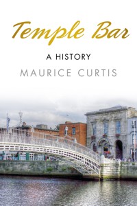
Early eighteenth-century map showing Custom House Quay area. (Courtesy of IHI)
From the early 1600s, Sir William Temple, the first provost of Trinity College Dublin, was the owner of some of the land in the area, which still bears his name. The Temple Bar area as we know it today originated in the old medieval city of Dublin and expanded eastwards from the early 1600s onwards. Over the following two centuries, it became a flourishing centre of trade, crafts and commerce, as well as social and political life. It also became the primary residential, commercial, political and dockland area of Dublin during the seventeenth and eighteenth centuries.1
Temple Bar is also filled with many triumphs of architectural design. The area is a feast of modern, original and highly stylish buildings integrating into the existing fabric. Renewal has embraced the old and the new and extended the life of Temple Bar for future generations. Every street and alleyway contains buildings of interest. The oldest houses are early-to mid-eighteenth-century buildings on Eustace and Fownes Street. There are also some interesting examples of eighteenth-and nineteenth-century brick-built warehouses, e.g. the Gaiety School of Acting building on Essex Street West, beside the theatre, and on Temple Lane South, Crown Alley and Cecilia Street. Temple Bar has furthermore become something of a showpiece for contemporary Irish architecture. The Wooden Building, the Green Building, Spranger’s Yard, Temple Bar Gallery and Studios, Curved Street and Meeting House Square, and the Ark are all significant buildings or spaces. This mix of old and new is part of what makes Temple Bar such an attractive and distinctive area.
Some of the most important names in Irish history have strong links to Temple Bar, including Oliver Cromwell, the Temple family, Richard and Robert Boyle, Jonathan Swift, George Faulkner, George Frederick Handel, Thomas Cooley, James Gandon, the Duke of Wellington, Richard Brinsley Sheridan, Margaret Leeson, Daniel O’Connell, Henry Grattan, Delia Larkin, the Sham Squire, Lord Edward Fitzgerald, George Berkeley, William of Orange, Molly Malone, Dorcas Kelly, James Joyce, Maria Edgeworth, Oliver Goldsmith, Thomas Moore, W.B. Yeats, Peg Woffington, Spranger Barry, Walter Osborne, Buck Whaley, ‘copper-faced Jack’, Harry Kernoff, Phil Lynott, Rory Gallagher, Aldo Rossi, Esther Vonhomrigh (Swift’s Vanessa), James Clarence Mangan, Joseph Sheridan Le Fanu, Bram Stoker, Wolfe Tone, Jeremiah O’Donovan Rossa, Arthur Griffith, Kevin Barry, Éamonn Ceannt, Seán MacBride and Robert Smyllie.
From the Vikings to the Victorians, practically every era of Irish history is represented in Temple Bar. The story of Temple Bar then is the story of Dublin, of Ireland – a story of tragedy and triumph, through times of oppression and prosperity, culminating in the vibrant centre we have in Dublin today. Temple Bar was and remains to this day a mirror that reflects the vicissitudes of time and the forces that have shaped us. It is also the story of the rise, decline and rebirth of one of Ireland’s architectural treasures.
Note
1. Pat Liddy, The Changing Landscapes of Dublin (Dublin City Info: Artane, Dublin, 2003)
1
MONKS OF THE TEMPLE –EARLY HISTORY
The growth and development of Temple Bar should be seen in the context of the wider history of medieval Dublin and Ireland. There is archaeological evidence to suggest that the area was first inhabited by Gaelic clans and subsequently by marauding Vikings in the tenth century. The western end of Temple Bar lies in part of the old city that was a Viking town. The remains of Isolde’s Tower, part of the thirteenth-century city wall, in Exchange Street Lower, indicate the importance of this part of the town.
To the east of this old city, outside the walls, the Augustinians built a monastery, the Holy Trinity Friary, in the late thirteenth century, in the area of modern-day Cecilia and Crow streets, with lands stretching along the banks of the River Liffey. The historic name of the district was not Temple Bar but St Andrew’s Parish, an eastern suburb of medieval (Anglo-Norman) Dublin, located outside the city walls. The old name survives in the form of St Andrew’s church, just off Dame Street.
FROM THE VIKINGS TO THE NORMANS
The Normans came to Dublin by invitation – an overture by Dermot MacMurrough, exiled King of Leinster. MacMurrough hoped to win back his kingdom, lost in a dispute with the High King of Ireland. His arrangement with Richard de Clare, the legendary Strongbow, was one of many reciprocal military actions between the Irish, the Welsh and the English at a time when lords and kings were jostling for power. Dublin town fell to the Normans in 1170. The Vikings fled to Oxmanstown on the north bank of the Liffey. Strongbow married Dermot’s daughter Aoife and exerted control over the city of Dublin to such an extent that his king, the Norman Henry II, came to Dublin in 1172 to check Strongbow’s power. In 1185, Henry declared his son John Lord of Ireland. John unexpectedly inherited the kingship and thus the Lordship of Ireland was tied to the English throne. From then onwards, Dublin started to take on its medieval shape with the building of Dublin Castle (1204–1230) on the site of an old Gaelic (subsequently Viking) fortification, the establishment of a proper administration structure, and the building of churches and monasteries. As early as 1192, Dublin Corporation was established and trade guilds encouraged. Over the succeeding generations, commerce improved and Dublin became a small city, necessitating the improvement of water and drainage, roads and houses and public buildings. The ruling Normans were used to greater convenience in their daily lives and set about laying water pipes as early as 1244. By 1245, a supply of water ran from the River Poddle to their grand stone castle on the hill. The tidal nature of the River Liffey at this point means it was undrinkable, so for generations Dublin residents resorted to alternatives – ale, wine and whiskey, hence Winetavern Street on the periphery of Temple Bar.1
The old defences were strengthened with the building of better walls and gates and towers. The only surviving old gate of Dublin (and of the thirteenth century) is on Cook Street, adjacent to the two St Audoen’s churches, with the old walls and battlements accessible from St Audoen’s Park on High Street. The remnants of Isolde’s Tower, one of the towers guarding the city, are still visible on Lower Exchange Street, which itself follows the direction of the old walls of Dublin.2
FROM THE MONKS TO THE REFORMATION
On the eve of the mid-sixteenth-century Reformation, the area now known as Temple Bar was sufficiently populous, albeit barely, to be served by a church, St Andrew’s. In addition to this church and the Thingmount, an old centre for administering justice, one of the most important features of Temple Bar was the open area known as Hoggen Green, now College Green. St Mary de Hogges Abbey was near this (on the site of present-day Bank of Ireland) and the Augustinian Holy Trinity Friary was halfway between this and the walls of the medieval city. Today, part of the thirteenth-century friary is visible within an apartment-restaurant complex called ‘The Friary’ in Temple Bar. The friary was founded about 1282 and its site is believed to be marked by the conjunction of Temple Lane, Temple Bar, Fownes Street Upper and Cecilia Street. The site has been partially excavated and is listed on the National Monuments Service database. Those excavations revealed around seventy burials from between the late twelfth century to the fourteenth century, remains of the friary on the east side of Cecilia House and, in 1996, excavations exposed a section of wall with a relieving arch and a corner tower.
Overall, three religious orders occupied more than half of the lands that now make up Temple Bar (the rest is the old city and the area consisting of land reclaimed from the rivers Poddle and Liffey and the surrounding marshland). The lands of the Augustinians and the nuns of St Mary de Hogges would subsequently be the basis for the newer, developed part of Temple Bar stretching from Parliament Street to Westmoreland Street. There was also an order of nuns on the lands presently occupied by Trinity College Dublin.
‘STICKY FINGERS’ BRABAZON
The Tudor conquest of Ireland from the mid-sixteenth century onwards spelt a new era for Dublin, with the city enjoying a renewed prominence as the centre of the colonists’ administrative rule in Ireland. These new colonists needed to be housed and rewarded for their services to the Crown. The suppression and confiscation of the monasteries during the English Reformation, from the mid-1530s, onwards facilitated this.
King Henry VIII (1491–1547), who became king in 1509, ordered that all churches, abbeys and monasteries were henceforth to be under his control. 60 per cent of Irish monasteries and friaries remained undisturbed in the Gaelic and Gaelicised parts of Ireland. Temple Bar, being in the Pale and under direct English influence and control, was not so lucky. If fact, the dissolution had an enormous impact on all of Dublin due to the concentration of cathedrals, churches, monastic houses and lands in the immediate vicinity of the city. The confiscated land was transferred to the English Crown via Dublin Corporation. The speed of land transfer was remarkable – many medieval estates and monasteries were transferred wholesale to private hands or to Dublin Corporation itself.
St Mary de Hogges went to the Crown. In 1591, the old monastery of All Saints was recommissioned as Trinity College Dublin. Cary’s Hospital was built on some of the open land at Hoggen (College) Green in 1595 and consisted of a large mansion, garden and a plantation by the seashore. This subsequently changed hands and was renamed Chichester House. It became the seat of the Irish parliament in the early seventeenth century. Finally, St Augustine’s Monastery was granted to the Sir Walter Tyrell, who came from a wealthy merchant family also involved in politics. One of his descendants, William Crow, later acquired the land. The Crow family soon built a number of large mansions and sublet plots of land.
Therefore, it is clear that the early history of the development of Temple Bar may be traced back to Dublin’s monastic settlement and the dissolution of monasteries in 1541 which began a new era in the eastward expansion and development of Dublin.3
Henry VIII gave the monastery of St Thomas Abbey (on Thomas Street in the Liberties) and the land around it to his vice treasurer in Ireland at the time, William Brabazon, who had been sent to Ireland in 1533. William Brabazon’s influence and control over government finances at the time of the Reformation had an enormous impact on the subsequent history of Temple Bar (and Ireland). It was he who oversaw the quick transfer of confiscated property to the treasury. Vice treasurer and three times Lord Justice, he was described by historian Hiram Morgan as the prototype New Englishman – ‘a hard man with sticky fingers’. Brabazon and other officials such as Lord Deputies Grey and St Leger profited by renting out confiscated land at rates far below market values and leaving thousands of pounds of rent arrears uncollected. This fraudulent activity was not uncovered until three years after his death. When the widespread corruption was brought to light in 1556, St Leger was dismissed, tried and fined £5,000.4
REBELLION AND THEGUNPOWDER EXPLOSION
Another important factor in the eastward expansion of Temple Bar was Queen Elizabeth I’s determination to make Dublin a Protestant city. She established Trinity College in 1592 (on confiscated monastic lands) as a solely Protestant university and ordered that the Catholic St Patrick’s and Christ Church cathedrals be converted into Protestant cathedrals. This move to Protestantise Dublin and extend the conquest, however, coincided with the great gunpowder explosion in Dublin in 1597. The background to the explosion was the English war against the Irish chieftains, the O’Neills and the O’Donnells, who had been successfully waging a campaign during the Nine Years’ War. English soldiers and supplies were arriving in Dublin port (by Wood and Essex quays) and, by accident or design, a number of barrels of gunpowder exploded dramatically in the heart of the old city, near Dublin Castle, killing over 100 people and destroying half of the small city. The buildings on Cook Street, Fishamble Street, Bridge Street, High Street and St Michael’s Lane suffered the most damage. This and the enormous cost of rebuilding led some merchants to decide to move eastwards, a move that was key to the growth and development of Temple Bar.5
Notes
1. Maurice Curtis, The Liberties: A History (Dublin: The History Press, 2013), p.143
2. Howard Clarke (ed.), Medieval Dublin: The Making of a Metropolis (Dublin: The Irish Academic Press, 1990), pp.183–200
3. Niall McCullough, Dublin: An Urban History (Dublin: Ann Street Press, 1989), p.24; F.X. Martin, ‘The Augustinian Friaries in Pre-Reformation Ireland’ in Augustiniana, Augustinian Historical Institute (Belgium), VI (1956), pp.347–384; Robert Somerville-Woodward & Nicola Morris, 17 Eustace Street: A History (Dublin: IFI/Timeline Research, 2007), p.5.
4. Hiram Morgan, ‘Sir William Brabazon’ in S.J. Connolly (ed.), The Oxford Companion to Irish History (Oxford: Oxford University Press, 1998), p.56; Maurice Curtis, The Liberties: A History (Dublin: The History Press Ireland, 2013), pp.26–8
5. Maurice Curtis, The Liberties: A History (Dublin: The History Press Ireland, 2013), p.29
2
CROMWELL, THE CROW’S NESTAND FAMILIES OF FORTUNE
From the middle to the late sixteenth century, a concerted effort was made to bring the whole country under the English system of government and the control of a parliament in Dublin. This culminated in the defeat of the Irish armies by those of Queen Elizabeth I at the Battle of Kinsale in 1601, which was followed by the ‘Flight of the Earls’ a few years later, when Ireland’s remaining major chieftains, including the O’Neills and the O’Donnells, left for the European continent. The plantation of Ireland, starting with King Henry VIII’s Tudor plantation, continued with the Elizabethan and Cromwellian plantations after the defeat of the Irish armies. These plantations built on the confiscations and forfeitures already begun with under Henry in the mid-1500s and continued with ever-greater severity the adverse possession of Irish property and land.
NOT QUITE FOOTBALL – CHICHESTER
One of the most important figures during the plantations was Sir Arthur Chichester (1563–1627), who commanded English forces in Ulster during the Nine Years’ War (1594–1603) and adopted a notorious ‘scorched earth policy’ in the belief that a winter’s famine would do more damage to the Irish forces than a million swords. Following the Treaty of Mellifont (ending the war) in 1605, he became Lord Deputy of Ireland with his residence at Chichester House on College Green, where the legal documents for the Plantation of Ulster were signed in 1612. He oversaw the plantation with great vigour as his brother Sir John Chichester had been defeated by the MacDonnells in the Battle of Carrickfergus in 1597. To compound matters, after the Irish victory, Chichester’s head had been chopped off and used as a football by the MacDonnell clan.
The planning and orchestration of the Ulster Plantation was directed from Chichester House in Temple Bar and from William Crow’s mansion on Crow Street, known as ‘the Crow’s Nest’. Over the following decades, some of the worst excesses of this State policy reached a crescendo, notably in the 1640s and ’50s. During the religious wars that wracked Ireland in those years, starting with the 1641 Rebellion, the new English Protestant authorities issued orders expelling all Catholics from the city limits and Dublin became dominated by Protestants. Until about 1800 this power and influence was essentially unchallenged, although towards the end of the eighteenth century voices in Grattan’s Irish parliament were heard to question this Protestant dominance of all things Irish.
Chichester House was subsequently the site of the Irish parliament. To this day, two important tapestries hang in the House of Lords building on College Green celebrating the new planters’ victories in the Siege of Derry (1688–89) and the Battle of the Boyne (1690). They are also a legacy of the ruthlessness of Arthur Chichester’s Plantation of Ulster, which speeded up the process of colonisation, and a monument to the allegiance of the members of the Irish parliament (known as ‘undertakers’) in the eighteenth century.1
Trinity College and the former Houses of the Irish Parliament, College Green, c. 1900. (Lawrence Collection, courtesy of National Library of Ireland (NLI) Commons Collection)
FROM BRABAZON TO TEMPLE
A number of names stand out in the consolidation of English influence and control of Dublin and in particular the growth and development of the Temple Bar area. Besides William Brabazon, who meticulously and avariciously oversaw the implementation of Henry VIII’s policy (dispossession of the monasteries and the forfeiture of lands), names such as Crow, Temple, Boyle, Eustace, Annesley and Fownes were very important in the new regime’s governance. This was reflected in their acquisition of land and property in the expanding eastern suburb extending from and including the old city. A 1627 inquiry showed a garden and house lately built by William Crow, adjoining Dame Street and a lane leading to the River Liffey (variously called Hoggen Lane, Dirty Lane and finally Temple Lane). This was close to the site of the original Augustinian monastery. The grounds of the monastery were taken for several houses built for Sir George Wentworth, Christopher Wandesford and the Crow, Eustace, Temple, Fownes and Annesley families.2
Dame Street from George’s Street junction, 1952. (Courtesy of IHI)
They were quick to avail of (and compound) the social, political and financial upheaval that Dublin and the rest of Ireland was undergoing. They were essentially exploitative pioneers in a merchant-based aristocracy, intent on owning and controlling as much of the land as possible. Once the land was forfeited by the monks or whichever Irish had originally legally owned it, it was automatically transferred to the ownership of Dublin Corporation, which leased out plots for a number of years to the new colonists. The Corporation, for instance, received from the Temple family an annual rent of £40 for part of the former monastic lands, on what is now called Temple Lane South, and for land behind the mansion’s garden, now part of Temple Bar.3
Consequently, within the enclave once owned by the Augustinian friars, there developed, in what was to become the Temple Bar of today, a grid plan of streets and alleys around the sites being acquired by individual colonists to build substantial houses and gardens. The names of those early carpetbaggers, the prominent families living in the Dame Street-Temple Bar area from the early seventeenth century, are still remembered in the area’s street names.4
TEMPLE TIMES AND TEMPLE’S BARR
In 1599, Sir William Temple (1555–1627), a renowned teacher and philosopher, entered the service of the Lord Deputy of Ireland. He had come to Ireland in that year as secretary to Robert Devereux, the Earl of Essex. Ten years later, he was made provost of Trinity College Dublin and Master Chancery in Ireland. Temple built his house and gardens on the corner of Temple Lane and the street now called Temple Bar. The site included some reclaimed land, which had formed part of the riverbank (‘barr’) of the Liffey estuary. In the seventeenth century, ‘barr’ (later shortened to ‘bar’) usually meant a raised estuary sandbank often used for walking on. Thus, the River Liffey embankment beside the Temple family’s plot became known as Temple’s Barr or simply Temple Bar. In 1656, Sir William Temple’s son, Sir John Temple, acquired additional land, the reclamation of which was made possible by the building of a new sea wall, which enclosed the extended property. The shoreline was gradually extended and enclosed over subsequent generations, having originally run along the present thoroughfare that extends from Essex Street, the Temple Bar street and Fleet Street. North of that line land was reclaimed from either the River Liffey or River Poddle.
Sir William Temple (1555-1627). (Courtesy of IHI)
TEMPLE AND CROMWELL
The 1641 Rebellion was essentially the Irish chieftain class rising up against the colonists, beneficiaries of earlier plantations. However, John Temple, before he acquired additional land, wrote a history of the 1641 Rebellion with a strongly partisan and sectarian slant. The book had a huge influence on Oliver Cromwell’s invasion of Ireland later in the decade. The Irish Rebellion, True and Impartial History (1644), reprinted as History of the Irish Rebellion (1646), was an exaggeration of the ‘massacres’, accompanied by sensationalist woodcuts depicting the Irish massacring thousands of settlers. This intentionally inflamed Protestant indignation against the native Irish, identifying English rule with God’s will and depicting the Irish Catholics as ingrates. This book contributed hugely to the severity of the Cromwellian campaign of 1649–52. In later years, the book was burnt by the public hangman on the orders of the short-lived Jacobite parliament in Dublin in 1689. It was reprinted many times over the ensuing centuries and helped confirm the colonists’ sense of entitlement.
Interestingly, Copper Alley in Temple Bar played a role in the 1641 Rebellion. Prior to the planned seizure of Dublin Castle by the Irish, ‘the conspirators arrived within the city, and having that day [22 October 1641] met at the Lion Tavern, near Copper-alley, ordered their affairs together, drank health’s upon their knees to the happy success of the next morning’s work’.5
The heightened ferocity and brutality of the 1641 Rebellion in John Temple’s book may be partly responsible for Oliver Cromwell’s order that the Irish go ‘to Hell or Connaught’ when he came in 1649. Two individuals based in Temple Bar, William Crow and William Petty, were instrumental in the Cromwellian Plantation that followed the defeat of the Irish.
WILLIAM CROW AND THE DOWN SURVEY
In 1597, Walter Tyrell’s heirs transferred their land in Temple Bar to William Crow, an important official in the Court of Common Pleas in Ireland. Subsequently, several large houses and accompanying gardens were built on his lands, near what is today Crow Street. One of these houses was the mansion of Crow himself, which over the first decades of the seventeenth century became known as the Crow’s Nest. The office of one of the most important officials in Ireland at the time was in this mansion. This was the office of the ‘Survey of the Forfeited Irish Lands’, which was in the hands of the meticulous Dr William Petty. Petty (1623-87), a doctor by training, had left England in 1652 to become a physician-general to Cromwell’s army in Ireland. In the space of thirteen months in 1654/5, he completed for the government the most important survey of Irish lands ever undertaken.6
PETTY’S SURVEY AND THE CROW’S NEST
Cromwell had borrowed huge sums of money from London merchants when he was planning the re-conquest of the country. He did this under the 1642 Act for Adventurers, which established the necessity of the re-conquest of Ireland and the financing of such a re-conquest: 1,500 wealthy investors were to be rewarded by having their money converted into parcels of land from the 2.5 million acres to be confiscated. Their investments essentially funded the suppression of the Irish rebels. However, only one third of the required £1 million was actually raised and following his victory, Cromwell had to repay his enormous loans and pay his soldiers. Some 32,000 officers, soldiers, followers, adventurers, settlers and creditors of every kind and class had to be paid. Cromwell’s solution was to pass anti-Catholic Penal Laws against the vast majority of the population of Ireland and, most importantly, confiscate huge tracts of their land. He did the latter with the help of his brutal policy, ‘To Hell or Connaught!’, the legality of which was underpinned by the Act for Adventurers. ‘Adventurers’ was a cryptic word in an age of exploration and exploitation.7
William Petty, author of the Down Survey, was based at the Crow’s Nest, Temple Bar. (Courtesy of GCI)
Having found it necessary to pay the troops with land taken from the defeated Irish, Cromwell needed a land survey. The appointed supervisor proved inept and in 1654 Petty volunteered to carry out the survey in thirteen months. His proposal was accepted and he employed about a thousand (strong and sturdy) men for the task. Petty, working from the Crow’s Nest, was responsible for the calculation, confiscation and transfer of Irish land ownership to the victors. In March 1656, he completed the survey on schedule. Although it was an incredible achievement, there were errors of underestimation of 10–15 per cent, which correspondingly lessened his pay.
According to historian Maurice Craig, ‘Petty seems to have been a man entirely devoid of sentiment or any imaginative attachment to the land in which most of his work was done. Petty looked on Ireland with the cold eye of the sophister, economist and calculator. He saw it merely as a description of square measurement. He was contemptuous of the Irish past and all forms of Irish autonomy were to him anathema.’8 Petty noted dispassionately that the upheaval (involving banishment, transportation or hanging) included 6,000 Irish children (of Irish soldiers), who were transported as slaves to the West Indies, the process easily facilitated by the Bristol sugar merchants, beneficiaries of the sugar plantations.
POWER, PLUNDER AND POSSESSION
Petty’s survey was referred to as the ‘Down Survey’. He noted down with ‘such exactness’, his findings, that there was no estate or property which was not distinctly marked and mapped. He presented his completed work on 5 million acres to the Exchequer in 1657 (about half the country, which consisted of the forfeited and expropriated land). From that date, Petty’s survey and the accompanying Books of Distribution were regarded by the government as the legal record of the titles on which half the land of Ireland was held (i.e. under new ownership). Following this survey, the distribution of forfeited lands was administered under the direction of Petty, with the help of forty clerks, effectively working around the clock. By January 1654, the 1,500 adventurers (investors) began planning for their share of the land, which made up nearly 1 million acres. Interestingly, despite the exactness of Petty’s work, the lots for the forfeited lands appear to have been drawn out of a hat and disputes regularly occurred over the profitable or barren tracts assigned to the various claimants. Despite that, and most importantly, the outcome of Petty’s Down Survey and the subsequent distribution of the forfeited land, implemented with brutal efficiency, was that Irish Catholic landowners were left with just over 20 per cent of the land, compared with 59 per cent in 1641. The new English colonial landed class, mainly Cromwellian and Protestant, along with those of the earlier plantations (in Ulster and Munster), now effectively owned and administered the country.9
Cromwell subsequently honoured Petty for his work and Petty’s payment for his survey enabled him to buy cheaply forfeited and mortgaged lands, thus acquiring considerable property, which he continued to augment throughout his life. This included 50,000 acres in County Kerry. Having acquired his wealth from other men’s misfortunes, Petty endured hostility and litigation for the rest of his life. In 1667, he married Elizabeth Fenton, the widow of Sir Maurice Fenton. The Fentons had connections in Temple Bar; they had a house on Copper Alley.10
FROM BOYLE’S LAW TO CORK HOUSE
Even before he came to Ireland, William Petty had known Richard Boyle (1566–1643), later to become the First Earl of Cork. Today Cork Hill is a reminder of one of the most influential and ruthless of the Temple Bar families of fortune that had such a resounding impact not only on the early development of Temple Bar, but on Ireland itself. Richard Boyle was the most successful of the New English colonists of the seventeenth century. Oliver Cromwell was an admirer of Boyle, saying once that if there had been more people like Boyle his task in Ireland in later years would have been unnecessary.11
Boyle was a fortune-seeker who came to Ireland in 1588 after being unable to afford to complete his legal studies in England. His was a rags-to-riches story of a man who understood the power of self-invention (he had achieved entry into official circles using forged introductions). By a stroke of luck, he was appointed Deputy Escheator of Crown Lands, which involved overseeing the legal transfer of lands to the Crown from those who had died without heirs. With the help of forgery, he exploited the legal uncertainties of land titles and built a substantial estate by coercing landholders and defrauding the Crown in the campaign against concealed lands.
His marriage to Catherine Fenton brought him respectability. Moreover, marrying the Limerick heiress, whose mother was Lady Alice Fenton (whose family had made its fortune from copper mining, with Copper Alley in Temple Bar called after her), was a politically astute and opportunistic move. Consequently, he became an important figure in the continuing English colonisation of Ireland in the sixteenth and seventeenth centuries as he rapidly acquired large tracts of land. He bought Sir Walter Raleigh’s Munster plantation at a knock-down price. This was part of his strategy of acquiring land by availing of the prior investment of others. Boyle was soon to be the richest man in Ireland, with a rent roll of £20,000. Even in those times of forfeiture and embezzlement of Irish land, such speed was unusual, but he did so with a single-minded ruthlessness by encouraging the settlement of Protestants and by suppressing the Irish clans and transferring them to the wilds of Kerry. This wealth brought him status and power.12
The Father of Modern Chemistry, Robert Boyle (1627-1691), son of Richard Boyle of Cork House, Cork Hill, c. 1689. Boyle’s Law, relating to the pressure and volume of gases, was one of his contributions to science. (Courtesy of Humphreys)
Boyle’s subsequent life was spent consolidating his fortune. Part of that fortune was spent building his house on Cork Hill (on the site of what is now City Hall), on the edge of Temple Bar. He had acquired the medieval church of St Marie de la Dam, which had been confiscated during the Reformation, and built a mansion on the site, known as Cork House because he was the Earl of Cork. Lismore Castle in Waterford was his primary residence and Cork House was his Dublin home. He was the wealthiest man in Ireland or England by the time of his death in 1643. The enormous family tomb (the Boyle Monument) erected in St Patrick’s Cathedral, Dublin, is a measure of the man – and this was just one of five monuments he commissioned for himself during his lifetime. Boyle erected this huge monument in 1632. His biographer Nicholas Canny confessed he would be loath to sit down at the same table with him and called him ‘the upstart Earl’. Historian Ken Nicholls described him as ‘a most repellent character but an extraordinary able one’. Historian R.F. Foster, in his Modern Ireland, calls him an ‘epitome of Elizabethan adventurer-colonist in Ireland’.13
Some of his sons played an important role in the rebellion (Irish Confederate Wars) of the 1640s and ’50s, fighting for English and Protestant interests in Ireland. One of the sons, Robert Boyle (1627–1691), is considered the father of modern chemistry, and the Royal Dublin Show (RDS) continues to award the Boyle Medal for scientific excellence. Interestingly, Robert’s scientific and meticulous approach was of particular help to William Petty in the 1650s when he was dissecting Ireland and transferring the forfeited lands to adventurers, soldiers, speculators and officials.
Eustace Street from Millennium Bridge. (Courtesy of Psyberartist, Wikimedia Commons)
FROM THE NORMANS TO MAURICE EUSTACE
Another individual with property in Temple Bar was Sir Maurice Eustace (c. 1590–1665), an Irish politician, barrister and judge. He spent the last years of his career as Lord Chancellor of Ireland, an office for which he felt himself to be unfit and in which he was generally agreed to be a failure. Eustace was descended from the old Norman family of Fitz Eustache. In 1639, he became Speaker of the Irish House of Commons and a few years later, in 1642, he was appointed by Charles I to negotiate with the Catholic Confederation in Kilkenny, which had assumed control of much of the country. In the 1660s, he was rewarded for his efforts to advance the Protestant religion when he was made Lord Chancellor and given a substantial amount of property in Dublin and Drogheda. His name was given to Eustace Street in Dublin city centre, where his town house, Damask, stood. No trace of Damask survives today, but it is known to have been one of the largest houses in Dublin and both the house and the gardens were much admired by Jonathan Swift.14
FROM ANNESLEY TO EARLDOM
Anglesea Street commemorates another prominent resident of the area, Arthur Annesley (1614–1686), created Earl of Anglesea in 1661 for services rendered in Ireland (effectively overseeing the continuation of Cromwell’s policy). He was born in Fishamble Street. He filled the office of vice treasurer from 1660 until 1667, served on the committee responsible for carrying out the settlement of Ireland and on the committee for Irish affairs, while later, in 1671 and 1672, he was a leading member of various commissions appointed to investigate the working of the Acts of Settlement. He amassed a large fortune in Ireland, including allotted lands given to him by Cromwell. This earl was great-grandfather of James Annesley, the principal figure in the famous Anglesea peerage case who died in 1760.15
29 Anglesea Street. (Courtesy of UCD Digital Library)
THE QUAY MEN – CRAMPTON AND ASTON
Bookseller, property speculator and former Lord Mayor (c. 1758), Philip Crampton knew the Temple Bar area well, having built Crampton Quay on reclaimed land on the southern shoreline of the River Liffey, and his involvement in the construction of Parliament Street gives an indication of his importance in the successful development of the street and the wider area of Temple Bar. He was a major landowner in Temple Bar; Crampton Lane, Quay, Court and Buildings are named after him.16
The corner of Essex Street in the early 1970s. (Courtesy of IHI)
Capel Street, Dublin, Tuesday 28 June 1960. (Photographer James P. O’Dea, courtesy of NLI Commons Collection)
Henry Aston was another prominent landowner in the area. The Temple Bar Square and Crown Alley area, on which the old Telephone Exchange is located, was part of his property, as was reclaimed land along the River Liffey (Aston Quay).
ARTHUR CAPEL AND LAVISH GIFTS
Today, Capel Street and Essex Street are reminders of a former English official who was the government’s representative in Ireland. Some argue that Arthur Capel, 1st Earl of Essex (1631–1683), was a contrast to the aforementioned avaricious families of fortune, which greedily encouraged the violence of the brutal and vicious forfeitures and confiscations outlined above. Essex was made Privy Councillor and Lord Lieutenant of Ireland in 1672. Although he was seen to be tolerant and had an independent approach to his job, he still hated Catholics.
He quickly showed an aptitude for understanding accounts, which was to lead to all kinds of challenges, including conflicts with Lord Ranelagh, who was put in charge of Irish taxes on condition of his supplying the requirements of the Crown up to 1675 and whose accounts Essex refused to pass. It has been suggested that his experience of the role was a principled struggle which was ultimately to lead to his recall – it was also an early sign of how out of step Essex’s integrity levels (if that was the case) were with those of his contemporaries. He strongly opposed the lavish gifts of forfeited estates to court favourites and mistresses. He prevented the granting of Phoenix Park to the Duchess of Cleveland. Finally, the intrigues of his enemies at home and Charles’s continual demands for money, which Ranelagh undertook to satisfy, brought about Essex’s recall in April 1677.17
Notes
1. John McCavitt, ‘Chichester, Arthur, Baron Chichester (1563–1625)’, Dictionary of National Biography (Oxford: Oxford University Press, 2004), p.291
2. Niall McCullough, Dublin: An Urban History (Dublin: Ann Street Press, 1989), p.24
3. Peter Pearson, The Heart of Dublin (Dublin: The O’Brien Press, 2000), p.34
4. Colm Lennon & John Montague, John Rocque’s Dublin (Dublin: RIA, 2010), p.xvii.
5. John Gilbert, History of the City of Dublin, Three vols (Dublin: Gill & MacMillan, 1978), Vol. I, p.93
6. John Gilbert, History of the City of Dublin, Three vols (Dublin: Gill & MacMillan, 1978), Vol. II, pp. 170–180
7. Ibid.; Hiram Morgan, ‘The Adventurer’s Act’ in S.J. Connolly (ed.), The Oxford Companion to Irish History (Oxford: Oxford University Press, 1998), p.4
8. Maurice Craig, Dublin 1660–1860 (Dublin: Liberties Press, 2006 (reprint of 1952 edition)), pp.79–80; Toby Barnard, ‘Petty, William’ in Oxford Dictionary of National Biography (Oxford: Oxford University Press, 2004); Margaret Anne Cusack, An Illustrated History of Ireland (London: MacMillan, 1868), Ch. 31
9. John Gilbert, History of the City of Dublin, Three vols (Dublin: Gill & MacMillan, 1978), Vol. II, pp.170–80; Hiram Morgan, ‘Cromwellian Land Settlement’ in S.J. Connolly (ed.), The Oxford Companion to Irish History (Oxford: Oxford University Press, 1998), pp.128, 483
10. Maurice Craig, Dublin 1660–1860 (Dublin: Liberties Press, 2006 (reprint of 1952 edition)), pp. 78–80; Eric Strauss, Sir William Petty, Portrait of a Genius (London: Glencoe, 1954), p.iii; The Dictionary of National Biography, new ed., XV, pp.999–1005; Sean O’Domhnaill, ‘The Maps of the Down Survey’ in Irish Historical Studies 3 (1943), pp. 381–392; John Gilbert, History of the City of Dublin, Three vols (Dublin: Gill & MacMillan, 1978), Vol. II, pp. 171–172
11. John Gilbert, History of the City of Dublin, Three vols (Dublin: Gill & MacMillan, 1978), Vol. II, p.5.
12. Hiram Morgan, ‘Richard Boyle’ in S.J. Connolly (ed.), The Oxford Companion to Irish History (Oxford, Oxford University Press: 1998), p.55; ‘The Boyle Monument’ in Guide to St Patrick’s Cathedral (2013).
13. John Gilbert, History of the City of Dublin, Three vols (Dublin: Gill & MacMillan, 1978), Vol. II, pp.3–7; George Smith in Concise Dictionary of National Biography, Part 1–1900 (London: Smith, Elder & Co., 1882), p.133; Nicholas P. Canny, The Upstart Earl: Richard Boyle, Earl of Cork (Cambridge: Cambridge University Press, 1982). Thanks also to Turtle Bunbury; R.F.Foster, Modern Ireland 1600-1972 (London: Penguin, 1988), p.8
14. F. Elrington Ball, The Judges in Ireland 1221–1921 (London: John Murray, 1926), pp.271–77; John Gilbert, History of the City of Dublin, Three vols (Dublin: Gill & MacMillan, 1978), Vol. II, pp.310–313.
15. ‘Arthur Annesley, 1st Earl of Anglesey’ in Encyclopædia Britannica, 11th ed., Vol. II (Cambridge: Cambridge University Press, 1911), p. 15; Maurice Curtis, To Hell or Monto (Dublin: The History Press Ireland, 2015), p.41
16. David Dickson, Dublin: The Making of a Capital City (London: Profile Books, 2014), p.183
17. Osmun Airy, ‘Capel, Arthur (1631–1683)’ in Leslie Stephen, Dictionary of National Biography 9 (London: Smith, Elder & Co. 1887), pp.12–17
3
RECLAMATIONAND EXPANSION
Temple Bar expanded gradually eastward during the sixteenth and seventeenth centuries. This was due to a number of factors. Firstly, as previously stated, there was the transfer of monastic lands to private ownership, as in the cases of the above-mentioned families. This was followed by the infilling of this land and the construction of houses and public buildings along adjacent thoroughfares. Secondly, the reclamation of land bordering the River Liffey shoreline and the building of Dublin’s quays further extended the amount of land that could be used for economic development. Moreover, the process of building the quays made reclamation easier and consolidated the size and extent of the area.
In 1610, the cartographer John Speed produced the first recognisable map of Dublin, which shows how the Temple Bar area looked in the early seventeenth century: it was not the uniform area we have today but a triangular area evenly divided with a barrier of river inlets, mud flats and marshland in the vicinity of where the Rivers Poddle and Liffey met. The Poddle, descending from the Dublin Mountains, entered the Liffey estuary by means of tidal sub-estuaries, which formed shifting shoals and bars. It ran overground and across Dame Street, weaving through the mud flats to the Liffey. Speed’s map shows that no part of the River Liffey was embanked or walled at this time. The river is shown flowing swiftly by the walls of the old city, which nestled on the south bank. East and west of the walls, bays, inlets and strands shape the landscape. The Liffey is busy with trading vessels, some anchored at ‘The Bridge’, which boasts a defensive gateway, controlling access to the city. The great Christ Church Bay, once a Viking haven, is now reclaimed land, supporting a riverfront portion of Dublin’s walls. Where the newer part of Temple Bar is now located (outside the old city walls and gates, from Parliament Street to Westmoreland Street) approximately half (northwards of Essex Street/Temple Bar/Fleet Street) was covered by the River Liffey in 1610. The main buildings shown on the map are Trinity College, the Augustinian monastery, the hospital, the bridewell (from St Brigid’s Well), Dame Street and Dame’s Gate, St Andrew’s church, and George’s Lane (now George’s Street).1
The subsequent building of the embankment of the river, begun not too long afterwards and gathering apace over the subsequent 200 years, involved much land reclamation, which resulted in additional development land, as well as improved access to Temple Bar. In particular, the large inlets and mudflats that divided the area were reclaimed, adding substantially to the development value and cohesion of the area.2
Of great importance in this reclamation process was the channelling, culverting and controlling of the area where the River Poddle flowed into the River Liffey. Crucial work took place in the early years of the seventeenth century, culminating in the triangular area of the Poddle outflow between the city wall and an old custom house being successfully reclaimed (the Poddle-Liffey confluence was a fan-shaped area stretching from what is now Parliament Street to Eustace Street).3 This development was significant for historical geographer Nuala Burke, who noted that ‘by enclosing the Poddle-Liffey confluence … the major physical obstacle to coherent eastward expansion was overcome, and the reclamation of this tiny area was to prove influential, out of all proportion to its size, in determining the form and character of subsequent urban development on both north and south banks of the Liffey’. Nowadays, the iron grating visible along the walls of Wellington Quay marks where the Poddle joins the Liffey.4
THE AGE OF EXPANSION
Further land reclamation then took place. As earlier noted, the line of Essex Street, Temple Bar and Fleet Street generally marked the original line of the seashore. The area north of that was underwater at high tide and belonged to Dublin Corporation, according to tradition. Entrepreneurs recognised the usefulness of the land in the water shallows. In the early 1600s, part of it was leased and enclosed by a stone wall at the low tide mark. From 1660, Dublin Corporation leased out the length of the Liffey from the countryside to the sea for development, effectively making waste space economically useful. Much of the land was leased to private individuals acting as sub-landlords, who in turn offered plots for development.5
In 1707, more of the seashore was leased for the construction of a new custom house and quay to replace an old building on Merchant/Wood Quay. This was located on Wellington Quay (then called Custom House Quay). This was linked to Dame Street by Crane Lane, which followed the bank of the River Poddle.6
This major land reclamation in the Temple Bar area from the seventeenth century onwards was to be the catalyst for an era of great activity and development. The latter decades of this century were ‘a period of heroic growth’ for Dublin. It was then that Dublin’s modern appearance took shape. It was a time for a new monarch, new money, new inhabitants, including thousands of Huguenots, and new ideas about Dublin.7
There was a lull in the mid-1600s because of the Cromwellian wars, but with the Restoration of Charles II in 1660 (whose reign lasted until 1685, though the Restoration era refers to the period up to and including 1715), Dublin was to see an improvement in its hitherto mixed fortunes as the growth and expansion of the city resumed. There was an explosion of the economy, the population and construction. Dublin became the permanent seat of parliament, government, trade and society. Temple Bar was at the hub of this change.8
The man responsible for facilitating this success was James Butler, Duke of Ormonde, who, with the Restoration of Charles II, returned in 1662 to govern as Lord Lieutenant of Ireland. Previously he had fought with the Royalists against Cromwell in the Irish Confederate Wars and, after Cromwell’s victory, had fled to Europe. He persuaded a generation of entrepreneurs to build in a more enlightened manner.9
The ambitious Ormonde put the River Liffey at the heart of Dublin by methodically directing the expansion of the city eastwards and also on the north bank of the Liffey – aided by wily developers, such as the Jervis’s and Gardiner’s. He instigated increased building along Dame Street, the reclamation of more land, and the building of new quays and bridges (e.g. Ormond Quay and Essex Bridge in 1678) to protect the reclaimed land and to make movement across the River Liffey easier. One of his lasting achievements was the open quays along the river; he constructed boulevards, thus reversing the trend of building houses right down to the water.10
This approach had huge implications for the growth and appearance of Temple Bar and Dublin. When Ormonde was promoted to viceroy for Ireland in the late 1670s, he greatly encouraged the building of what is now Ormond Quay, persuading the local property owner Sir Humphrey Jervis that this was his price when Jervis asked for his support in the building of Essex Bridge and Capel Street. With the construction of the quay, which separated houses from the River Liffey, a blueprint emerged for future development along the river.


