Erhalten Sie Zugang zu diesem und mehr als 300000 Büchern ab EUR 5,99 monatlich.
- Herausgeber: Phillimore & Co Ltd
- Kategorie: Sachliteratur, Reportagen, Biografien
- Sprache: Englisch
Gerrards Cross, known for its open common and picturesque Latchmore Pond, had been a place of resort ever since the 1790s. Genteel houses sprang up, attracting enough wealthy visitors that it began to be known as the 'Brighton of Bucks.' The opening of the Great Western and Great Central Joint Railway in 1906, with a station at Gerrards Cross, gave hundreds of Londoners the opportunity to live in 'Beechy Bucks.' Gerrards Cross: A History celebrates the energy and imagination of the pioneer architects, builders and estate agents who ensured that Gerrards Cross became a high-class residential area, both socially and architecturally. It also applauds the entrepreneurs who opened their new shops and services when the commuter houses were still on the drawing board, and the brave newcomers who brought their families to live in the country, but depended utterly on their reliable train service to London.
Sie lesen das E-Book in den Legimi-Apps auf:
Seitenzahl: 255
Veröffentlichungsjahr: 2023
Das E-Book (TTS) können Sie hören im Abo „Legimi Premium” in Legimi-Apps auf:
Ähnliche


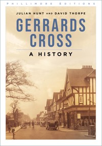
An architect’s impression of new shops at Gerrards Cross, 1907, signed by Walter F.C. Holden, then an assistant to the architects, Kerkham, Burgess & Myers.
First published 2006
This paperback edition first published 2023
Phillimore, an imprint of
The History Press
97 St George’s Place, Cheltenham,
Gloucestershire, GL50 3QB
www.thehistorypress.co.uk
© Julian Hunt and David Thorpe, 2006, 2023
The right of Julian Hunt and David Thorpe to be identified as the Authors of this work has been asserted in accordance with the Copyright, Designs and Patents Act 1988.
All rights reserved. No part of this book may be reprinted or reproduced or utilised in any form or by any electronic, mechanical or other means, now known or hereafter invented, including photocopying and recording, or in any information storage or retrieval system, without the permission in writing from the Publishers.
British Library Cataloguing in Publication Data.
A catalogue record for this book is available from the British Library.
ISBN 978 1 80399 402 4
Typesetting and origination by The History Press
Printed and bound in Great Britain by TJ Books Limited, Padstow, Cornwall.
eBook converted by Geethik Technologies
Contents
List of Illustrations
Acknowledgements
Foreword
Introduction
1. Gerrards Cross in its Geographical Setting
2. The Parish of St James, Gerrards Cross
3. The People of Gerrards Cross, 1851-1901
4. The Railway
5. Shops and Offices
6. Building the Houses
7. The Newcomers
8. The End of Geographical Expansion
Appendices
1. Architects
2. Builders
3. Estate Agents
Notes
Bibliography
List of Illustrations
Frontispiece: Station Parade, 1907
1. Bulstrode Camp, 1876
2. Bull Inn, Oxford Road, c.1910
3. French Horn, c.1900
4. Packhorse Inn, c.1955
5. Packhorse Inn, 1931
6. Bulstrode, 1730
7. Gatehouse, Bulstrode Park
8. Bulstrode Park, c.1900
9. Chalfont Park, c.1900
10. Lodge, Chalfont Park, c.1900
11. Woodhill, Oxford Road, 1907
12. The Rancho, Oxford Road, c.1865
13. St Hubert’s, 1910
14. Alderbourne Manor, c.1930
15. The Memorial Centre, East Common, c.1950
16. Latchmoor House, c.1900
17. Latchmoor, c.1900
18. Woodbank, Bull Lane, 1906
19. Ethorpe Hotel, 1947
20. Map of Orchehill Estate, 1842
21. Orchehill House, c.1900
22. Lodge, Packhorse Road, c.1920
23. St James’s Church, c.1900
24. Gerrards Cross Church of England School, 1908
25. Aged Pilgrims’ Home, 1874
26. St Hubert’s Cottages, East Common, c.1930
27. Heatherside and Gerrards Cross Cottage, East Common, c.1900
28. The Old Post Office, Oxford Road, 1913
29. H.J. Bonsey, butcher, East Common, c.1900
30. Gerrards Cross Station, 1907
31. Gerrards Cross Station, 1908
32. Gerrards Cross Station staff, 1919
33. Great Central Railway advertising, 1906
34. Station Road, 1908
35. L.H. Tayler, grocer, Station Road, c.1910
36. A. Woodbridge, ironmonger, Station Road, 1908
37. F.H. Bonsey, butcher, Station Road, 1908
38. R. Exton, grocer, Station Road, 1908
39. W. Payne, bicycle maker, Station Parade, 1908
40. Former Post Office, Packhorse Road, 1913
41. 1-6 Station Parade, 1910
42. Wood & Son, confectioners, Station Parade, 1908
43. Orchehill Chambers, Packhorse Road, 1907
44. Station Parade, c.1940
45. A. Smith, dairyman, Oak End Way, 1908
46. T.H. Roff, greengrocer, Oak End Way, 1908
47. Oak End Way, c.1912
48. Park Creamery, Oak End Way, c.1912
49. Gerrards Cross Post Office, 1918
50. Station Parade, c.1940
51. The Highway, c.1930
52. Boots the Chemists, The Highway, 1932
53. Cinema, Ethorpe Crescent, 1925
54. Station Road, c.1950
55. New shops, Packhorse Road, c.1960
56. Shops, Packhorse Road, c.1990
57. Plan of building plots on Orchehill estate, 1906
58. Badsey Cottage, 5 Kingsway, 1913
59. Three Pigeons, Austenwood Common, c.1960
60. Turret House, Packhorse Road, c.1910
61. Lyncroft, Packhorse Road, 1947
62. Oval Way, 1939
63. Hillsborough Lodge, 2 Oval Way, 1908
64. Brown Cottage, 15 Oval Way, 1907
65. Stokel, 25 Oval Way, 1914
66. Riva, 54 North Park, 1910
67. Grit Howe, 22 South Park Crescent, 1907
68. South Park House, 8 South Park Drive, 1911
69. The Dormers, 13 South Park Crescent, 1912
70. The Tudors, 19 South Park Crescent, 1990
71. Ben More, 5 Oak End Way, 1914
72. Swarthmore, Marsham Lane, c.1950
73. The Thatched House, Marsham Lane, 1910
74. Davan House, 38 The Woodlands, 1907
75. Chiltern House, 21 The Woodlands, 1907
76. Sarum, 17 Queensway, 1928
77. Latchmoor estate, 1908
78. The Square House, 5 Latchmoor Grove, 1908
79. Briarhedge, 33 Orchehill Avenue, 1908
80. The White Gate, 30 Latchmoor Way, c.1939
81. Churston, Bull Lane, 1908
82. Brackenhurst, 91 Orchehill Avenue, 1922
83. The Downs, Austenwood Lane, 1912
84. Old Basing, Austenwood Lane, 1913
85. Plan of Bulstrode Way, Hampton & Sons, 1907
86. Bulstrode Way, 1910
87. Fremar, Bulstrode Way, 1915
88. Little Orchards, 6 Layters Way, c.1910
89. Marsham Way, c.1950
90. The Wyke, 16 Marsham Way, 1920
91. Marsham Manor, Marsham Lane, 1912
92. Somersby, 22 Fulmer Way, 1911
93. Howard House, Vicarage Way
94. The Paddock House, West Common, 1914
95. The Glen House, Woodhill Avenue, 1926
96. Callcott Dene, Woodhill Avenue, 1927
97. Cornerways, 38 Mill Lane, c.1950
98. The Bumbles, Woodhill Avenue, 1935
99. Dukes Wood Avenue, c.1935
100. Dukes Mead, Manor Lane, 1928
101. Felbrigg, Fulmer Road, 1939
102. Dukes Wood Drive, 1957
103. Winnards Perch, 47 Windsor Road, 1934
104. Timbercombe, 77 Windsor Road, 1983
105. Gosmore, 111 Windsor Road, 1938
106. Garden Reach, Camp Road, 1935
107. Stoneygate, Top Park, 1936
108. Old Tyles, Camp Road, 1936
109. Gaviots Green, c.1955
110. Old Tyles, Camp Road, 1936
111. Thorn House, 14 The Woodlands, 1930
112. Mill End, 21 Mill Lane, 1915
113. Diss Park, Marsham Lane, 1906
114. The Rowans, 22 Marsham Way, 1907
115. Glendruid, 10 Oval Way, 1911
116. Farleigh, 56 Bulstrode Way, 1913
117. Allendale, 53 Bulstrode Way, 1908
118. Eastwood, 9 Oak End Way, 1908
119. The Pollards, 3 Oval Way, 1914
120. Kimberley, 22 Oval Way, 1908
121. Abbotsmead, Marsham Lane, 1907
122. Kingslea, 101 Windsor Road, 1934
123. Whitewood, Windsor Road, 1934
124. St Bernards, Oak End Way, 1906
125. Oldhurst, 35 Bulstrode Way, 1909
126. Doulma, 11 Fulmer Way, 1910
127. Old Tile House, 2 Layters Way, 1910
128. 9 Latchmoor Avenue, 1925
129. Thorpe House School, Oval Way, 1925
130. Arkley, 69 Marsham Way, 1922
131. Broadeaves, Ethorpe Close, 1930
132. French Horn, Oxford Road, c.1960
133. West Lodge, 48 Bulstrode Way, 1908
134. Wyke House, 50 Bulstrode Way, 1908
135. Wisteria Cottage, 53 Orchehill Avenue, 1910
136. Craiglea House, Austenwood Lane, 1914
137. Cottered, Austenwood Lane, 1919
138. Bull Mead, Bull Lane, 1916
139. Badminton House, 38 Marsham Way, 1913
140. Merok, North Park, 1910
141. Roughwood, East Common, 1923
142. Turret House, 115 Packhorse Road, 1909
143. Y.J. Lovell & Son offices, Marsham Lane, 1906
144. The ‘Lovell House’, 1926
145. Y.J. Lovell & Son staff, 1907
146. Lynbury, 14 South Park Crescent, 1910
147. A.C. Frost’s office, Station Approach, 1908
148. A.C. Frost’s office, Station Parade, c.1940
149. Augustus Gibbons’ office, Station Parade, c.1908
150. J.G. Hetherington’s office, Packhorse Road, 1931
151. Brendon and Malmsmead, 10-12 Orchehill Avenue, 1910
152. Hillsborough Lodge, 2 Oval Way, 1909
153. Verulam, 24 South Park, 1926
154. The Priory, 1 South Park Crescent, c.1930
155. The Abbey, South Park Crescent, 1912
Acknowledgements
The authors owe a special debt of gratitude to Harvey Parr, who has project managed this book and the accompanying exhibition to be staged at Gerrards Cross in April 2006. They would also like to pay tribute to Barbara Lyddiatt and Charlotte Morrison, who spent many days working in the Centre for Buckinghamshire Studies in Aylesbury, helping to list the collection of Eton Rural District Council building regulations plans. The style and content of this book is heavily influenced by the house plans made by the various architects working in Gerrards Cross between 1906 and 1939. Permission to use these drawings has been given by South Bucks District Council and by A. & Q. Partners of Beaconsfield.
The majority of the photographic illustrations have come from the collection of Colin Seabright of Chesham Bois, nos. 2-3, 10-1, 13, 15-6, 21, 24, 26-31, 34, 39-40, 42, 47, 49, 51, 62-4, 72, 77, 79-80, 86-7, 99, 109, 135, 149 and 154. Official sources of illustrations include Beaconsfield Historical Society, nos. 41 and 71; Birmingham Reference Library, no. 12; Centre for Buckinghamshire Studies, nos. 4, 17, 19, 22-3, 25, 32, 36-8, 44-6, 48, 54-6, 59, 61, 65, 81, 88, 89, 101, 104, 126, 134, 140, 146-8; Cornwall Record Office, no. 20; Gerrards Cross and Chalfont St Peter Historical Society, no.78; Royal Institute of British Architects Library, nos. 67, 91, 123 and 131; and Worcestershire Record Office, no. 57. Other illustrations are from Abbeyfield Gerrards Cross Society, no. 90; Audrey Baker, no. 7; Buckinghamshire Advertiser, no. 14; Hamptons International, no. 70; Keith Hyllier, no. 102; David Lovell, nos. 95, 105, 108 and 145; and Colin Smythe, nos. 6, 8-9, 35, 50, 60, and 97. Information and assistance has been provided by the Archivist, Brasenose College, Oxford, Michael Brogden of WEC International, Ian Colston, John Dodd, Doug Freeman, Alan, John and Nicola Frost, Raymond Glenny, Gerry Hoare, Ian Johnson of B.P. Collins & Co., Trevor Kent, Anthony Lock of Thorpe House School, David Lovell, Peter Lomas, Robin Morrison, Peter Roberts, Geoffrey Seagrove, Nigel Stewart-Wallace, Kareen Stuart, Bill Taylor, A.P. Whitley and James Worthington.
Special thanks are due to Buckinghamshire County Council, Gerrards Cross Parish Council and South Bucks District Council for their support in producing this book and to The Frost Partnership, Hamptons International and the Roberts Newby Partnership, sponsors of the accompanying exhibition.
Foreword
The project to celebrate the centenary of the coming of the railway to Gerrards Cross started in October 2003 when the Bucks Archaeological Society held its Annual History Conference at the Memorial Centre, Gerrards Cross. The highlight of the day was a guided tour of Gerrards Cross led by David Thorpe. At the Gerrards Cross Summer School in August 2004, a day school on the history of Gerrards Cross was given by Julian Hunt. From this emerged an exhibition planning group, including Trevor Kent, Barbara Lyddiatt, Charlotte Morrison and Councillor Jennifer Woolveridge, soon to be joined by Harvey Parr, Councillor Malcolm Barres-Baker and Nigel Halliday.
The group were keenly aware of the planning crisis facing Gerrards Cross and many similar towns and villages, where soaring land values are causing developers to demolish the very houses which make these settlements so attractive. Even during the preparation of this book several fine houses have been lost, to be replaced by flats or houses of little architectural merit. It is the hope of our team that by drawing attention to the best architecture in Gerrards Cross we can save key buildings from this destructive process. We are fortunate indeed that some of the finest British architects of the early 20th century left their mark on Gerrards Cross. We have buildings by nationally known architects such as Baillie Scott, P. Morley Horder, Forbes & Tate and Edgar Ranger, and by excellent local architects such as Burgess, Holden & Watson and Robert G. Muir. Gerrards Cross was indeed the home of Y.J. Lovell and Son, whose houses featured year after year at the Ideal Home Exhibition. It is our duty to preserve their work, and, where redevelopment does take place, to encourage developers to commission architects and builders of equal imagination and skill. To do otherwise may eventually produce a settlement so devoid of charm as to lower, rather than raise, property values.
I would like to thank Julian Hunt and David Thorpe for bringing our group together and for enabling us to produce this permanent record of our unique community.
JENNIFER WOOLVERIDGE
GERRARDS CROSS PARISH COUNCIL, 2006
Introduction
This book commences with the histories of several great houses which, although situated in five different parishes, all came to give their address as Gerrards Cross. It was the concentration of such genteel households around Gerrards Cross Common which gradually gave character to the area and caused it to be called ‘The Brighton of Bucks’, at least forty years before the district was opened up by the railway. The book goes on to analyse the occupations and social position of the original residents and compares them with the origins and aspirations of the newcomers who settled here after the opening of the railway in 1906. The book then describes the process of building the new houses, highlighting the architects, builders and estate agents who shaped the modern Gerrards Cross. The authors hope to show that Gerrards Cross, far from lacking history, has ancient and fascinating origins and an architectural heritage which makes it one of the most desirable places in this country in which to live.
This account of the history of Gerrards Cross is selective. We have limited overlap with earlier studies such as those by Edmonds and Baker. After exploring some earlier topics, the focus is on the 19th century and the first 40 years of the 20th century, the period when Gerrards Cross became a parish and then a special type of suburban village. In this it draws on sources that were either not available to the earlier authors, or were not fully utilised by them. The data that has emerged from them is very rich. It not only forms the basis for much of this book but is also to be used in a companion volume, An Historical Atlas of Gerrards Cross 1840-1940, and may be presented in other forms.
For the purposes of this study, Gerrards Cross has been defined as an area larger than that of the modern parish. It includes that part of Chalfont St Peter approximately south of School Lane, including Austenwood Common, which for much of the 20th century carried a Gerrards Cross postal address.
One
Gerrards Cross in its Geographical Setting
The fact that Gerrards Cross is not mentioned in Domesday Book does not mean that the area was not settled at the time, or that it lacked significance. The British hill fort now surrounded by Camp Road is one of the largest fortifications in Buckinghamshire and was clearly a centre where the population of a wide area could seek protection in times of trouble. By 1086, any British tribal boundaries had long since been replaced by those of Roman and then Saxon estates, but it appears that a topographical feature like Bulstrode Camp, and the large area of open land which surrounded it, did not fit easily into the parish system. The new parishes north of the Thames were arranged in long thin strips so that each had meadows and arable near the river and summer pastures and woodland to the north. The tax assessments made in 1086 on the manors of Chalfont St Peter, Iver, Langley Marish and Upton cum Chalvey must have taken into account their respective claims to the area of waste land first known as Chalfont Heath, and later as Gerrards Cross Common. These parishes shared the rich resources of the Heath, including summer pasture, water from the ponds, wood for building and fuel, and clay for bricks, tiles and pots. At some early period, their conflicting claims must have been resolved by marking out boundaries defining the area of the Heath belonging to each parish.
1 Bulstrode Camp, from the 1st Edition Ordnance Survey Map, 1876.
The largest portion of Chalfont Heath was naturally within the parish of Chalfont St Peter, and extended north-east from the Oxford Road, up to the area of common arable land called Latchmoor Field. The eastern part, straddling the Oxford Road, belonged to the parish of Iver, where the estates called Oak End and Woodhill were established at an early date. The northern part of Langley Marish also had a boundary on Chalfont Heath. Here was land called Alderbourne, belonging to Ankerwyke Priory, Wraysbury, and a farmstead called Prestwicks, meaning the priest’s farm. Fulmer does not appear in Domesday Book but it soon afterwards emerged as a separate parish, including the ancient hill fort and that portion of Chalfont Heath south-west of the Oxford Road which the locals called Fulmer Heath, or Fulmer Common. A further part of Chalfont Heath, west of the hill fort, belonged to Upton cum Chalvey. This extended over 123 acres and became the site for the mansion called Bulstrode Park. The boundary between Fulmer and this detached portion of Upton cum Chalvey was an old road, marked on the 1686 Bulstrode Estate map, which was a continuation of Bull Lane, crossing the Oxford Road near to the Bull Inn.1
Early References to Gerrards Cross
The editor of a 1921 directory addressed the issue of the lack of history in Gerrards Cross by relating the local tradition of the origin of the name. He told his readers that in the days of the stage coach, ‘Gerrard’ or ‘Jarrett’ had been a popular landlord of a coaching inn, situated where the road to Slough crossed the Oxford Road. He suggested that the publican’s name had clung to the spot long after the inn had been demolished. This plausible story is repeated in many guide books to Buckinghamshire and the Chilterns, but in reality Gerrards Cross is much older than the stage coach.
There are, however, many earlier references to the place-name ‘Gerrards Cross’. As early as 1448, a rental of the Abbot of Missenden’s manor at Chalfont St Peter lists a William Bulstrode paying 12d. per year for ‘land in the field near Geraddescrosse’. In a Chalfont St Peter court roll of 1555, a tenant is fined 12d. for cutting down two trees at ‘Gerarde Crosse on le hethe’.2 More dramatically, the Chalfont St Peter parish register in November 1580 records the burial of ‘Thonas Davyes murthered by one Richard Hassell at Jarretts Crosse’.
These references establish the antiquity of Gerrards Cross, but they do not tell us which ‘Gerrard’ was so fondly remembered, or so deeply feared, that his name was attached to the place. One candidate appears in a survey of Chalfont St Peter, probably prepared for the Abbot of Missenden, about 1333. It lists Nicholas le Plomer the elder and Nicholas le Plomer the younger as holding a quarter of a virgate of land of ‘Gerard of Chalfont’.3 It is not clear where this land was, but the document does show that ‘Gerrard’ was a Christian name used by at least one wealthy family in Chalfont St Peter in the 14th century.
The editor of the 1921 directory took the ‘cross’ in Gerrards Cross to refer to the cross-roads in the centre of the Common, where the road to Slough crosses the Oxford Road. All the early travellers maps and estate maps, however, locate Gerrards or ‘Jarretts’ Cross at the west end of Chalfont Heath, near to Latchmoor Pond and to the Bull Inn. If the name does refer to a crossroads, it may have been at that point where Bull Lane once crossed the Oxford Road and continued down to Hedgerley Lane. It was probably this road which was diverted by the Earl of Portland, with the consent of his neighbours, in 1707.
Most English place-names including the ‘cross’ element, however, refer to a boundary cross, or the mark of an important meeting place. A likely place for such a cross would be the point on the Oxford Road where the western side of Chalfont Heath was divided between Chalfont St Peter and Fulmer. The cross referred to in the place-name may even have been one of a series of crosses marking another boundary. It was common for religious houses to mark the boundary of their remote properties with a circuit of crosses. Temple Bulstrode, an estate within Hedgerley, which bounded the Oxford Road and had belonged successively to the Knights Templar, the Knights Hospitaller, Burnham Abbey and, from 1337 until the Dissolution of the Monasteries, to Bisham Abbey, may have been defined in this way.
Latchmoor Pond
Whether the name Gerrards Cross referred to a crossroads, a waymark or an estate boundary, it must have been a welcome stopping place on the great road from London to Oxford. The nearby Latchmoor Pond would have been a rare but vital source of drinking water for travellers and their pack-horses as they crossed the high ground between Uxbridge and Beaconsfield. The pond would have been especially useful to those driving animals to London, or to more local markets. The place-name Latchmoor is something of a tautology, being made up of lache, Middle English for a bog, and mere, Old English for a pool. Latchmoor Pond must indeed be ancient, for it gave its name to the common arable field called Latchmoor Field on which much of modern Gerrards Cross was built. It was only natural that farmers in the vicinity of the pond should have sold beer to the better-off travellers and drovers passing along the Oxford Road and that the more popular beerhouses became inns like the Bull Inn.
The Oxford Road
As early as the 16th century, the poor condition of English roads was seen as a great obstacle to economic development. Roads were barely adequate to get produce to local markets and the surfaces were so poor that most goods were carried by pack-horses rather than wagons. In order to promote internal commerce, an Act of 1555 made every parish responsible for the repair of its own roads. Churchwardens appointed surveyors who were to encourage every parishioner to spend up to four days a year working on the roads. In 1563, a further Act increased the number of days to six and made Justices of the Peace responsible for ensuring that parishes fulfilled their obligations. These Acts would place a particular burden on parishes like Chalfont St Peter and Fulmer, whose boundary was the great road from London to Oxford. In 1573, the tenants of the manor of Temple Bulstrode agreed to repair the part of the king’s highway leading from Beaconsfield to ‘Gerardescrosse’ that lay in the parish of Hedgerley.4 The next year, Edward Bulstrode was ordered to repair the king’s highway leading from ‘Steppy lane towards Gerardes Crosse’. Henry Bulstrode of Bulstrode Park evidently took advantage of the system, as he is accused in the Chalfont St Peter court rolls in 1606 of having encroached on the waste, ‘being the king’s highway leading from Gerardes Crosse towards Beaconsfield, with a great ditch and hedge’.5
Turnpike Acts
English trade increased dramatically during the 17th century, making the inadequacies of the road network even more obvious. Tacitly admitting that forced labour was insufficient to repair the nation’s roads, Parliament passed an Act in 1662 enabling parish surveyors to levy a highways rate to be spent on road maintenance. The first successful attempt to relieve parishes of the duty to maintain a major road, and make the carriers and ordinary travellers pay instead, came in 1663. In that year, a private Act of Parliament was passed, enabling the Justices of the Peace of Hertfordshire to charge tolls and apply the proceeds to repairing a 15-mile section of the Great North Road near Royston. The success of this scheme led to the formation of other trusts, where local Justices of the Peace managed sections of major roads where they passed through particularly difficult terrains. The 1706 Act, which authorised the charging of tolls on a 15-mile stretch of Watling Street from Fornhill in Bedfordshire to Stony Stratford in Buckinghamshire, established an even greater precedent. The Act gave the power to charge tolls, not to the Justices of the Peace, but to a committee of local gentry and tradesmen. This set the pattern for the formation of local trusts to maintain main roads across the country for the next 150 years. The toll roads became known as ‘turnpikes’, as the gates erected across the roads where tolls were to be collected resembled the spiked barriers, or ‘turnpikes’, more familiar at castle gates.
The first part of the road from London to Oxford to be turnpiked was the 15-mile section from Tyburn to Uxbridge, for which an Act of Parliament was passed in 1715. Two Acts passed in 1719 turnpiked the 12-mile section from Beaconsfield to Stokenchurch and a further 18 miles from Stokenchurch to Oxford. Maintenance of the 8 miles of the Oxford Road from Uxbridge to Beaconsfield remained the responsibility of the parish surveyors for another 30 years. The missing link in the local turnpike network was put in place by an Act of 1751, which turnpiked ‘the road leading from the west end of the said town of Wendover to the end of a lane called Oak Lane, next to the great road called the Oxford Road, lying between the town of Beaconsfield in the said County of Bucks, and Uxbridge in the County of Middlesex, and that part of the said great road which leads from the west end of the said town of Beaconsfield to the River Colne near Uxbridge.’ The Act claimed that these roads were ‘very deep and founderous, and inconvenient and dangerous to persons and carriages passing the same’. It gave responsibility for maintaining these two sections of road to the Buckingham to Wendover Turnpike Trust, which had been in operation since 1720. To the list of existing trustees were added over 80 gentlemen from the south of the county, including Lord George Bentinck, brother of the owner of Bulstrode Park, the Rev. Winch Holdsworth, Vicar of Chalfont St Peter, Lister Selman, owner of Chalfont Park, and Richard Whitchurch, lord of the manor of Chalfont St Peter.
In the 1770s, responsibility for maintaining the roads from Wendover to Oak Lane and Beaconsfield to Uxbridge passed to separate turnpike trusts. An Act of 1777 created a new trust to repair the road from the west end of the town of Wendover to the end of a lane called Oak Lane, next the great road called the Oxford Road, and also half a mile of road from the River Colne towards Beaconsfield. Another trust was established by an Act of 1779 to repair the Oxford Road from the west end of the town of Beaconsfield to within half a mile of the River Colne, near Uxbridge. Curiously, the remaining half mile of road into Uxbridge was repaired by the Wendover to Oak Lane End Trust as late as 1852.
Toll Collectors’ Houses
Travellers on the Wendover to Oak Lane End road had to pass toll collectors’ houses at the west end of Great Missenden and at the bottom of Gravel Hill, Chalfont St Peter. A new toll collector’s house was built at Great Missenden in 1827 and that at Chalfont St Peter was replaced with a new turnpike house at Oak End in 1828. Travellers on the Oxford Road passed toll gates opposite the Dog and Duck, Denham, at Red Hill, near the turn to Amersham, at Holtspur, west of Beaconsfield, and at London Road, High Wycombe. All of these toll houses have been demolished, but the ornate toll house at High Wycombe was moved in 1978 and rebuilt at the Chiltern Open Air Museum. Several of the milestones erected by the turnpike trustees survive, notably those at either end of Gerrards Cross Common.
The early turnpike Acts gave trustees powers to charge tolls and to repair the roads for a period of 21 years only. There were four acts for the Wendover to Oak Lane End Road: 1751, 1777, 1812 and 1833. The last Act, however, extended the trustees’ powers for 31 years plus the period to the end of the parliamentary session then in progress. Similarly, there were five Acts for the Beaconsfield to Uxbridge Road: 1751, 1779, 1806, 1828 and 1852. The last Act of 1852 was known as the Beaconsfield and Red Hill Road Act and moved responsibility for repairing the last half mile of road into Uxbridge from the Trustees of the Wendover to Oak Lane End Road to those of the Beaconsfield and Red Hill Road. The powers conferred on the trustees by this Act were to continue in force for only 12 years plus the time remaining in the parliamentary session then in progress. This meant that the powers of the Wendover to Oak Lane Trustees and those of the Beaconsfield and Red Hill Trustees would expire in the same year.
With the opening of the London to Birmingham Railway, and part of the London to Bristol Railway in 1838, income from tolls on coaches and carriers’ carts declined rapidly. The Wendover to Oak Lane trustees’ powers expired in 1865 and the trust was wound up in the following year. The toll collector’s house at Oak End was sold to John Nembhard Hibbert, of Chalfont Park, for £65. The funds still in the treasurer’s hands were divided between the parishes which would once again be liable to repair their sections of the road. Chalfont St Peter received £10 17s. 0d.6 The trustees of the Beaconsfield and Red Hill Turnpike closed their accounts in 1867. The toll houses at Denham and at Red Hill were sold in December 1867 to Benjamin Way of Denham Place for £25 each.7 The Red Hill toll house was demolished for road widening in January 1929 and the Denham toll house was taken down in February 1931.8
Coaching Inns
The inns on the Oxford Road at Gerrards Cross pre-date the turnpike era, having provided accommodation both for travellers and their horses from at least the mid-17th century. Each inn would have an ostler on hand to replace the stage coach horses, whilst the passengers took refreshment during the 15 or so minutes allowed for the stop. The innkeepers would also hire out horses to pull private coaches to similar inns in the next large town.
Beaconsfield and High Wycombe, being respectable towns roughly half-way between London and Oxford, had several inns catering for those who wanted to break their journey overnight. One such inn was owned by Edward Marshall of High Wycombe, who died in 1698. The inventory attached to his will lists all the furniture, fire irons, bedding, carpets, curtains and tapestries in 16 guest rooms. Each room was named after an important visitor, such as the King’s Chamber, the Queen’s Chamber, or the Duke’s Room, or given the name of a coach which changed horses at the inn, including the Fleur de Lis, the Phoenix or the Worcester. The prizers also listed goods in Mr Marshall’s own room and those of his ostler and maids. Debts owing to the deceased included £8 from Mr Edward Bartlett of Oxford, coach master, and two sums of £20 and £40 owed by ‘Mr Moore that keeps the Oxford stage coach’.9
In 1836, the following coaches passed through Gerrards Cross on their way to London: the Union, from Birmingham; the Berkeley Hunt, from Cheltenham; the Regulator and the Retaliator, both from Gloucester; the Champion, from Hereford; the Blenheim and the Age, from Oxford; The Thame Safety Coach and J. Coles Omnibus, both from Thame; the Hope, from Warwick; and the Sovereign, the Telegraph, the Paul Pry and the Royal Mail, all from Worcester.10


