Erhalten Sie Zugang zu diesem und mehr als 300000 Büchern ab EUR 5,99 monatlich.
- Herausgeber: Penned in the Margins
- Kategorie: Sachliteratur, Reportagen, Biografien
- Sprache: Englisch
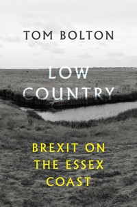
"Out on the estuary a slab of land had separated itself from the horizon and was moving closer" Shortlisted for the New Angle Prize 2019 In 2016 Tom Bolton set out on a mission to walk the long, winding coastline of Essex — from Purfleet on the Thames Estuary to the Suffolk border. Low Country records his probing, hallucinatory journeys along crumbling sea-walls and through retail parks, past abandoned military forts and plotlands. He uncovers an ancient battlefield upstream from a decommissioned nuclear power station, visits England's most deprived community and treks the remote and beautiful Dengie peninsula in search of forgotten stories. In the treacherous mudflats and coastal resorts of England's eastern edge, an alternative vision begins to emerge, shaken by Brexit and the rise of new, populist politics in Britain and America. In this low country of vast horizons, where land and sea are in constant flux, Bolton discovers a hidden history of invasion, resistance and radical thinking. A timely new book from the celebrated author of London's Lost Rivers and Vanished City, Low Country repositions the edgelands of Essex at the political and imaginative heart of England.
Sie lesen das E-Book in den Legimi-Apps auf:
Seitenzahl: 239
Veröffentlichungsjahr: 2018
Das E-Book (TTS) können Sie hören im Abo „Legimi Premium” in Legimi-Apps auf:
Ähnliche


LOWCOUNTRY: BREXITONTHEESSEXCOAST
Tom Bolton is a writer and researcher. His books and essays include Vanished City: London’s Lost Neighbourhoods, London’s Lost Rivers: A Walker’s Guide and Camden Town: Dreams of Another London. He has completed a PhD called Wrong Side of the Tracks? The Development of London's Railway Neighbourhoods.
PHOTOGRAPHY by Tom Bolton
MAPILLUSTRATIONS by Oliver Barrett
ALSOBYTOMBOLTON
London's Lost Rivers: A Walker's Guide (Strange Attractor, 2010)
Vanished City: London's Lost Neighbourhoods (Strange Attractor, 2014)
Camden Town: Dreams of Another London (British Library, 2017)
PUBLISHEDBYPENNEDINTHEMARGINS
Toynbee Studios, 28 Commercial Street, London E1 6AB
www.pennedinthemargins.co.uk
All rights reserved
© Tom Bolton 2018
The right of Tom Bolton to be identified as the author of this work has been asserted by him in accordance with Section 77 of the Copyright, Designs and Patent Act 1988.
This book is in copyright. Subject to statutory exception and to provisions of relevant collective licensing agreements, no reproduction of any part may take place without the written permission of Penned in the Margins.
First published 2018
Printed in the United Kingdom by TJ International
ISBN: 978-1-908058-59-1
ePub ISBN: 978-1-908058-70-6
This book is sold subject to the condition that it shall not, by way of trade or otherwise, be lent, re-sold, hired out, or otherwise circulated without the publisher’s prior consent in any form of binding or cover other than that in which it is published and without a similar condition including this condition being imposed on the subsequent purchaser.
THANKS
This is for Jo, who did just as much walking as me.
Many thanks to Tom Chivers at Penned in the Margins for his enthusiasm, expert editing and hard work in making this book what it is.
Thank you to Jeff Barrett and Diva Harris at Caught by the River, for publishing the original essays that formed the basis for Low Country, and encouraging me to keep writing them.
Thank you to Brian and Toni Dawson, for patiently shepherding us along the Broomway, passing on essential information and bringing us back safely.
Thank you to Peter and Rosalind Bolton for background research, timely ideas and increasingly obscure references.
— TB
CONTENTS
Introduction
IGateway
IIEstuary
IIIDengie
IVNorthey
VBlackwater
VITendring
VIIMersea
VIIIMarsh
IXThe Naze
X
‘There are places, just as there are people and objects and works of art, whose relationship of parts creates a mystery.’
PAULNASH, OUTLINE (1949)
INTRODUCTION
On a Friday night in early Spring 2016, Jo and I met after work at Liverpool Street Station to take the train to the Essex coast. We had been walking the coast off and on for several years, using spare weekends and bank holidays to inch our way around the margins of Britain. We were living in south London, where Jo grew up, and to where I had moved after university. Both of us loved the city and lived our lives within its ebb and flow, but we were also drawn away from the centre to the edge, and to the sea. The smooth hills and chalky edges of Sussex and the cliffs, bays and marshes of Kent pulled us from London. So we developed a deceptively simple plan. We would walk along the entire coast of south-east England, through the car parks, sewage works, industrial estates and oil refineries, as well as places designed for day trips. We began by walking out of London along the south bank of the Thames towards the protrusions of Kent, the Sussex havens and cliffs.
I was brought up in a village in the south Warwickshire countryside, in a triangle between Stratford-upon-Avon, Warwick and Leamington Spa. Warwickshire lies deep in the heart of England, as far from the coast as it was possible to retreat, weighted by history and cushioned by geological layers on all sides, rimmed with bands of igneous rock. As a child, I felt the pull from sharper edges at the horizon: the retreating, layered hills to the west, where the Malverns climb towards the Marches, the Black Mountains and, eventually, the distant Welsh coast at Aberdovey and Fishguard, where the Irish Sea bends into the sunset.
We made steady progress. By the end of 2015 Jo and I had walked the coastlines of Kent, East Sussex, West Sussex and Hampshire all the way to the Solent, with a detour to loop around the Isle of Wight. But we had yet to visit Essex. Although close to London, the Essex coastline seems designed to deter the casual visitor. It is little visited and unfashionable, its landscape barely known. Visitors look past Essex to the Areas of Outstanding Natural Beauty in nearby Suffolk, far enough away from London to seem like a proper holiday. The Essex coastline also presents a particular set of physical barriers; multiple broad estuaries, lethal mudflats, coastal reclamation projects, collapsing sea-walls, eroding cliffs, munitions depots, Ministry of Defence firing ranges and seasonal ferries stand in the way of the day tripper. One of the county's largest islands, Foulness, although equipped with a network of public footpaths, can only be reached via a low tide path called The Broomway, a track branded ‘the most dangerous footpath in Britain’.
It is often claimed that Essex has the longest coastline of any English county at 350 miles. There is far more of Essex than seems possible. Its estuarine complexity, compounded by the shifting relationship between land and sea, means that the length of its coast changes with the tide and is more or less impossible to measure. Indeed, the very concept of a coastline is inherently unstable; there is no single accepted definition of its physical form. In parts of Essex the high and low tidelines are more than a mile apart.
On a map of northern Europe, Essex is a mirror image of the Netherlands. Each landmass, facing each other across the North Sea, is licked by long tongues of water – low countries of marshland, islands and tidal creeks. This is more than just appearance: the Dutch brought their drainage skills to England in the 16th century, turning Essex into a reclaimed outpost of their own country with a new, firmer coastline protected by long sea-walls.
Essex also specialises in islands. I was intrigued to discover that there are 19 inhabited islands in Essex, from the larger and better known such as Canvey and Mersea, to a host of smaller, inaccessible islands: the off-limits military zone of Foulness and the Essex Archipelago; the privately-owned Osea Island in the Blackwater; semi-accessible nature reserves such as Ray Island, Skipper’s Island and Northey; and a succession of uninhabited or abandoned locations, from Bridgemarsh Island, where the sea came flooding in over the marsh in the 1930s, to Wallasea, where the sea-wall was deliberately breached and much of the island handed back to the sea. And there are also ghost islands, abandoned after catastrophic breaches of their sea-walls, leaving just a trace of their outline on the map.
We could no longer resist the mysteries of a county so near to home. The task would require research and planning. We strung together the trains, buses and, occasionally, taxis that would connect us to the low country of Essex, and calculated routes between overnight stays. We consulted the small canon of Essex coast writing of which a highlight was 350 Miles, a limited-edition pamphlet of essays by Ken Worpole and desolate photographs by Jason Orton – just the kind of niche literature that leads me to visit obscure places. We identified sites of dereliction to seek out, hidden stories to follow.
During the course of 2016 and 2017, Jo and I walked the 350 miles of the Essex coast – all except those stretches closed to the public by the Army or an encroaching North Sea. We became regular Friday night visitors to Liverpool Street Station, where we boarded trains to Burnham-on-Crouch, Colchester, Thorpe-le-Soken, Walton-on-the-Naze, Harwich and Manningtree. Our starting point was the Essex county boundary at Rainham Marshes, tucked between a landfill site and the M25 motorway crossing. We pushed out along the Thames Estuary past the Crowstone at Southend, an obelisk out on the sands which, half-submerged at high tide, marks the end of the river and the start of the North Sea. As we tracked upstream along estuaries and then downstream along the opposite banks, we became increasingly aware that we had chosen an exceptionally strange time for our walks. Political events – a referendum, surprise elections in Britain and the US and the stream of chaotic blowback that followed – formed the background to our coastal trips. A rising tide of populism took the political establishment completely by surprise. Not only that, but as I walked, I began to realise that these strange events might have unexpected origins in Essex.
Essex is a place everyone thinks they know. It has some of the most familiar stereotypes anywhere in the country, but it seems to date back only a generation. In 1979 Margaret Thatcher entered government thanks to a working-class shift to the Conservatives. It was centred on Essex, and the bellwether constituency of Basildon. On the suburban fringes of London, Basildon and the unglamorous, suburban towns of the London/Essex fringe were unfashionable and overlooked before ‘Essex man’, the council-house-buying archetype of the new Tory voter, scorched a new, brash vision of Essex into the culture. Essex found itself both the beneficiary of the new economic boom – Jags and yachts, property investment and sambucas, Florida holidays and Ray-Bans – and the butt of the joke. Essex man and Essex girl knew what they enjoyed, could afford to buy it, and did not care what anyone else thought. They were easily mocked, most notably by sketch comedian Harry Enfield, whose character ‘Loadsamoney’ instantly became part of the 1980s’ highlights reel. Thirty years on, the reality TV series The Only Way is Essex, so popular it is only known by its initials, has recycled the same themes as parody. One of its stars, Joey Essex, is named after the place he comes from and is famous for being stupid.
The Essex story has consumed itself, but the politics burns more fiercely than ever. I knew that beyond the reductive media images, Essex has a quite different history: of radical politics, social experiment and alternative ways of living. It has been a place of exile, where progressive thinkers and artists have retreated to shape their philosophies. The path was from city to country, Londoners moving east to see things differently. Working-class east London had moved, often without much choice, into the Essex suburbs after the Second World War. However, this new, forward-looking society built on socialism, new towns and new ways of living had also seeded Thatcher's counter-revolution. Then, in the early 1990s, a group of Essex MPs ignited the anti-European movement with their opposition to the Maastricht Treaty agreement negotiated by John Major’s Conservative government, to which they belonged. Major’s time may seem distant now but the Maastricht rebels have never really gone away; their ideas spawned UKIP, the EU referendum of 2016 and the march towards Brexit. People underestimated by the country as a whole, and the capital in particular, have taken a grip on national politics and identity in a way that seems certain to define an era. Essex is more than political caricature and London overspill. The east of the county is remote, and the long stretches between seaside resorts little visited by outsiders. The opening lines of J.A. Baker’s Essex nature book The Peregrine describe the dividing line between country and marshland Essex: ‘East of my home, the long ridge lies across the skyline like the low hull of a submarine. Above it, the eastern sky is bright with reflections of distant water, and there is a feeling of sails beyond land.’ Hidden downwind of London, in the shadow of its suburbs, the coastal areas remain obscure.
During our entire time on the Essex coast we did not encounter anyone else who seemed to be engaged in long-distance walking. Local walkers emerged close to settlements, often with dogs, soon dropping away as we passed out again into the marshes. Farmers crossed our path, almost always in the far distance. I later discovered that Worpole had predicted our project, astutely identifying those ‘who have returned to exploring the terrain on foot ... a new kind of secular pilgrimage, based on immersion.’ Our walk was exactly that. It provided space for thinking and the consolation of the outdoors, which proved welcome as our sense of reality and our understanding of the country we lived in was undermined by the referendum, the election of Donald Trump in the US and the polarisation of politics into Remainers and Leavers, Liberals and the Alt-Right, us and them. In Essex, big skies and distant horizons seemed to offer release and, perhaps, the freedom to see our country more clearly.
I
GATEWAY
THELINEOFTHEESSEXCOUNTYBOUNDARY across Rainham Marshes Nature Reserve is marked only by a collapsed chainlink fence, an abandoned border crossing. Its crooked cement posts fixed both the end of London and the start of our journey along the Essex coast. As Jo and I crossed the boundary fence and walked to the edge of the reserve, a sleeping bag lay discarded in the middle of the path and, further along, a fire site blackened the earth. High above us, an early skylark twittered and purred like a busy modem. We paused, looking towards Dagenham. The Thames was dwindling into the distance. Then we turned east to begin our 350-mile walk to the other end of Essex, following its meandering coast all the way. Our first walk would take us to Benfleet, halfway up the Thames in the direction of Southend-on-Sea. As we crossed the boundary, Jo felt a strange, electric tingling along her arm. There was a charge in the air.
We had set ourselves a project, to walk the Essex coast, attracted by the lure of the overlooked, of places that no one bothered to visit. I was also intrigued by the idea of marshes, an unfamiliar setting with undertones of mystery and danger. To begin our journey, Jo and I headed for Purfleet, on the Thames Estuary. The boundary between the London Borough of Havering and the County of Essex lies halfway across the leftover slice of wetland at Rainham, deep among the estuary’s industrial landscapes. Most people pass through on their way to Southend, but the estuary has its own, dedicated railway line, the C2C, that leads nowhere else; it threads east among riverside logistics parks, power stations and overpasses, passing through east London on a viaduct beside the Thames to Southend and Shoeburyness, where both the river and the line come to an end. Beyond lies only white space on the map, merging into the light brown of mudflats, where sea and land become hard to separate. The spread of the light brown is as large as the white, pushing out across the North Sea channels.
Many of the capital’s noxious industries are to be found alongside the estuary in the outer boroughs of Barking and Dagenham and Havering, as well as under the shadow of the M25 bridge. They lie in the Thames Gateway, an area optimistically rebranded in the late 1990s to welcome housing estates and new town centres that have proved slow to arrive. Since the industrial revolution Essex has been a convenient place to dump anything London does not need or want: from toxic waste shipped to landfill to effluent pumped into the Thames by machines such as those found at the ornate, Victorian pumping station at Crossness.
Essex is also very flat. John Norden, writing in 1594, observed that ‘[i]n this shire are no great store of hills.’ The railway journey gave us a high-line tour from the viaduct, revealing abandoned works huts, invisible from the street, and offering close-up views of rumpled sheets in chain hotel bedrooms. We passed through Dagenham Dock into territories unknown. This is where industrial London has ended up, squeezed out of the centre to the very edges. There were almost no people to be seen, only Eddie Stobart lorries and Canute tankers parked up beside impossibly large grey and pastel warehouses. The tankers advertised: ‘Personal solutions for you, wherever you are in the world.’
On the train, Jo read an article about the variable nature of time. Time, she told me, passes more slowly at sea level than higher up, for example in the mountains. The difference in the distance rotated by the Earth can be measured by placing clocks at contrasting altitudes. The clocks show a small disparity that grows over time. Life passes more quickly at altitude, and a person spending their time in the mountains lives and ages faster. At sea level – zero feet – there is more time, whether or not anyone realises. The literal pace of life differs from place to place, and slowest of all was the route we would be taking, as close to sea level as the path would take us.
We left the train at Purfleet, the first town in Essex, in long-term transition from a military base and port to something else, still to be defined. Creative industries were welcomed to Thurrock, now the town's preferred name. The Royal Opera House in London had moved its scenery workshops here some years before, but the anticipated cultural economy remains elusive. Meanwhile, in 2014 the World Health Organisation reported that this area had the highest levels of particulate air pollution in the UK.
Purfleet is synonymous with the Esso Fuel Terminal. Its hulking storage tanks dominate the riverfront, surrounded by tracks of cleared land. Railway Cottages, the 19th-century terraces opposite the station, had been boarded up and marked as ‘acquired for development’, with the exception of one lone, cussed house in the middle, still occupied.
This was our first visit to Rainham Marshes. Separated from Purfleet by the culverted Mardyke, the marshes are said to resemble the pre-industrial state of the Thames basin. Before drainage, development and embankment, the river was wider and slower than it is now and washed across much of inner south London at high tide. The pre-urban landscape was good for duck hunting but poor for staying dry. London’s marshes were drained and pushed to the very edge of the city, leaving Rainham as a remnant connecting Greater London to Essex.
We crossed a wooden bridge to an elevated hide operated by the Royal Society for the Protection of Birds (RSPB), an observation platform with a wetland vista, backed by power stations, overpasses, pylons and sluice gates. Visitors were recording the migrating birds that come and go from Africa and Europe, stopping at Rainham on their bi-annual global trips. A whiteboard reported the day’s spots in black marker, with coloured bird illustrations. Willow, sedge and reed warblers were arriving on the marshes. Terns were fishing on the river. With a pair of huge binoculars, a volunteer showed me a solitary Great Egret in the far distance that looked like a scrubbed heron.
It was immediately clear to us that Rainham had been a Ministry of Defence firing range, disused and reclaimed for public use. An array of rifle targets still stood on the marsh topped with carved, greying numbers. In 1990, Rainham had been seriously considered as a location for a theme park run by the American company Universal Studios. Twenty-five years on, Paramount Pictures is planning a park on the opposite bank, in Dartford. Regular gunfire echoed over the site from the Kent bank, where the remaining shooting range on Dartford Marshes was busy. The embanked path ran along a sea-wall and was dotted with small groups of birders, mostly men in safari jackets and floppy sunhats, carrying telescopes in their own miniature rain covers. Jo and I took the path across the reserve, beside the Thames, towards the rounded, green hill of the former landfill site, studded with black plastic vents. A group of young men headed around the perimeter fence towards the Ford plant at Dagenham, each carrying a can of cider and a cigarette.
In the river beside the reserve, we spotted a series of tar black posts standing in grey mud, the remains of a 6,000-year-old forest. A tangle of tree trunks – ash, elm and alder – are preserved in brown peat beneath the river mud. The trees belong to the Neolithic era, and flint tools found here hint at hunter-gatherers who roamed the Thames shore. The relict forest links this coastline straight back to a darker, wilder place far beyond the edge of recorded history. The ancient stumps – astonishing archaeology, noticed by almost no one – seemed to me a sign that this was a good place to be searching for the underside of Britain.
We left Rainham Marshes, passing the single surviving building of the Royal Gunpowder Magazines complex. Purfleet had been the central storage facility for Britain’s gunpowder from the Napoleonic Wars to the Second World War. It was housed in five magazine warehouses, specially constructed to resist bombardment, each containing more than 10,000 barrels of powder. The information board noted that workers had not been allowed to smoke. Purfleet Barracks, once nearby, had vanished without trace, but the riverside housing that had replaced them faithfully replicated the Barracks’ atmosphere.
I knew Purfleet through Dracula, which was surely its trump card. Bram Stoker located Carfax House, the count’s estuary residence, in Purfleet and it was here that he had come ashore in boxes of earth shipped from Transylvania. It is likely that Stoker had actually visited Purfleet, a popular Victorian day trip destination from London, and appropriated its dark, secluded atmosphere. ‘It is surrounded by a high wall, of ancient structure, built of heavy stones, and has not been repaired for a large number of years. The closed gates are of heavy old oak and iron, all eaten with rust.’ However, Stoker had fictionalised the setting so that no ideal model for Carfax House could be found, and there was certainly no associated Goth festival as in Whitby. The painter Jock McFadyen’s 2001 work From Dracula’s Garden presents a view of the Thames Estuary dominated by the distant, smoking form of the castle-like Coryton Refinery, visible to the east on the Essex skyline. Purfleet had put up a blue plaque nonetheless, beside the main road, and the Dracula connection drifted in the diesel from cars ploughing through the small centre, as we tracked away from Rainham Marshes.
The Queen Elizabeth Bridge carries the M25 motorway over the Thames, passing high over Thurrock and crashing to earth far in the distance, an epic urban structure like the New Jersey Turnpike or the Brooklyn Bridge but without an accompanying city. Beneath its concrete span, West Thurrock is one long service centre, where the logos of two key players in the politics and economy of 21st-century Britain, Amazon and the Daily Mail, are emblazoned on a succession of otherwise indistinguishable, corrugated grey units of astonishing size. As we trekked along the estuary, the traffic on the bridge streamed over the river and entire neighbourhoods in a single sweep. The fuel that powers the cars and lorries is stored in the huddle of white steel cylinders that make up the Grays Oil Storage Depot. Beyond, the small town of Grays is dominated by the vast, disused State Cinema, an art deco complex built in 1938.
Life has been sucked from Grays, vampire-style, by the neighbouring retail black hole at Lakeside, Thurrock. The State Cinema has been saved from a generation of decay by Wetherspoon’s, which is converting the building into an enormous pub. Tim Martin, the chain’s owner, had recently stepped up his anti-EU rhetoric and was planning an active role in the referendum campaign to come. Later, he was to accuse ‘an elite, mostly graduates of Oxford or Cambridge Universities’ of ‘groupthink’ and indulgence in a ‘quasi-religion’ in their support of the EU. His comments, combining a grain of truth with a vast helping of parody, distilled the mood of the moment to perfection.
Grays is tucked into the inside of a bend in the Thames. Where it turns back east we cut inland to walk around the perimeter of Tilbury Docks. Tilbury is Britain’s Ellis Island, the port where the repurposed troopship Empire Windrush docked from Jamaica in 1948, carrying not only passengers from the West Indies, but a group of 66 Poles. They had travelled all the way around the world to escape Nazi Germany, arriving in Britain via Siberia, the Pacific and Mexico before joining the Windrush in Jamaica. American poet Denise Levertov described the emigration that had drawn her family through Essex on their way across the Atlantic: ‘Something forgotten twenty years: although my fathers / and mothers came from Cordova and Vitesk and Caernarvon, / and although I am a citizen of the United States and less a / stranger here than anywhere else, perhaps / I am Essex born.’ Tilbury had none of the tourist buzz of Ellis Island. Instead, it was just the two of us, marching around the fence that kept us away from the container stacks, and three boys in a hurry, one of whom, for reasons best known to himself, was carrying a crowbar.
At Tilbury, we spotted an even larger Amazon warehouse squatting beside the railway line. Tilbury Power Station is separated from the Thames by a concrete sea barrier. The path between wall and river, around the power station’s hard security line. It was painted from end-to-end with murals only visible to those who passed close by, the scale all the more surprising for being hidden away. Pleasantly surprised by the outbreak of wild colours in a landscape of grey concrete and mud, we photographed Asterix and Obelix, Homer Simpson and a selection of Mod revival symbols and slogans. A full-size version of Roy Lichtenstein’s pop art painting Whaam! was fading away like the residue of the explosion it portrayed. Beyond was the wide estuary, and the distant Kentish shore.
Before the better-remembered periods in his life as a writer, dissenter and spy, Daniel Defoe ran a brickworks at Tilbury. He lived in a farmhouse on the marshes nearby and described his neighbourhood in the 1720s in A Tour Through the Whole Island of Great Britain. Between Barking and Dagenham, he recorded, ‘The famous breach, made by an inundation of the Thames, which was so great, as that it laid near 5,000 acres of land under water.’ The floodwaters remained for 10 years until the breach was eventually repaired by one Captain Perry, fresh from engineering for the Czar of Russia on the River Don. Even this close to London, the Essex coastline is vulnerable, dependent on hard engineering to keep it intact.
Leaving the docks, we encountered Tilbury Fort, incongruously squeezed between a distribution park with a wind turbine and sewage works. The fort was built for Charles II and later described by Defoe as ‘a water bastion ... the largest of England.’ It was London’s main defence from Thames invaders until the Second World War. An impressive double moat and fortifications cut decorative star shapes into the marsh. Before the fort was constructed, this site was where Elizabeth I had famously addressed troops preparing for a Spanish invasion, making her ‘body of a weak and feeble woman; heart and stomach of a king’ speech. There are few sites in Britain with such an engrained place in island history – Hastings, Runnymede maybe, Sir Francis Drake’s bowling lawn – but to us it existed as a notional location, detached from geography and floating somewhere among a world of history book illustrations for children. At the perimeter of the fort, a white, weatherboarded pub sat beside the river in strange isolation: The World's End.
After the sewage works, the flat lands lay before us and, for the first time, we experienced the strange sensation of walking along a sea-wall, balanced on an endless ridge. This would later become very familiar. The path was positioned above the surrounding countryside on an earth embankment, sometimes topped with a concrete path. This would revert without warning to tall, thick grass, a struggle to pass through. We could see its course running away far ahead of us. Rather than becoming absorbed into the landscape through walking, the sea-wall separated us and kept us constantly aware of our elevated position.


